Bridge Statistics for Bolingbrook, Illinois (IL)
Condition, Traffic, Stress, Structural Evaluation, Project Costs
- National Bridge Inventory (NBI) Statistics
- 44Number of bridges
- 791ft / 241mTotal length
- $2,492,000Total costs
- 1,217,850Total average daily traffic
- 145,271Total average daily truck traffic
- National Bridge Inventory (NBI) Registered Bridges for Bolingbrook
- No street view available for this location
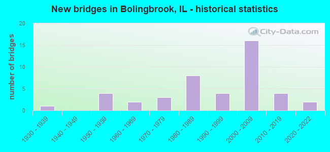
- New bridges - historical statistics
- 11930-1939
- 41950-1959
- 21960-1969
- 31970-1979
- 81980-1989
- 41990-1999
- 162000-2009
- 42010-2019
- 22020-2022

- Reconstructed bridges - Historical Statistics
- 11970-1979
- 11980-1989
- 01990-1999
- 12000-2009


- Bridge Condition - Deck
- 8.3%Very good
- 33.3%Good
- 33.3%Satisfactory
- 8.3%Fair
- 16.7%Poor

- Bridge Condition - Superstructure
- 28.6%Very good
- 42.9%Good
- 14.3%Fair
- 7.1%Poor
- 7.1%Serious

- Bridge Condition - Substructure
- 21.4%Very good
- 50.0%Good
- 14.3%Satisfactory
- 14.3%Fair

- Bridge Condition - Channel
- 4.2%Excellent
- 29.2%Very good
- 41.7%Good
- 16.7%Satisfactory
- 8.3%Fair

- Bridge Condition - Culverts
- 5.6%Excellent
- 22.2%Very good
- 16.7%Good
- 27.8%Satisfactory
- 22.2%Fair
- 5.6%Serious
Find on map >> Show street view
Structure Number: 220186, Location: 1 MI N. OF I-55 (Lat: 41.716994, Lng: -88.033314), Route carried "on" structure: Interstate 355, Year Built: 1988, Status: Open, Structure Length: 1.02m (3.35ft), Average Daily Traffic: 51,750 (year 2020), Truck Traffic: 8%, Average Future Daily Traffic: 74,962 (year 2032), Design Load: HS 20, Features Intersected: LILLY CACHE CREEK
Minimum Vertical Clearance: 30+ m (98+ ft), Kilometerpoint: 21.838, Lanes on structure: 4, Base Highway Network: Yes, Toll: On toll road, Owner: State Toll Authority, Approaching Roadway Width: 39.3m (128.9ft), Skew: 1 degrees, Material/Design: Concrete, Design/Construction: Culvert, Number Of Spans In Main Unit: 3, Length of Maximum Span: 3.0m (9.8ft)
Condition: Channel: Very good, Culverts: Satisfactory, Operating Rating: 97.2 metric tons, Method Used To Determine Operating Rating: Load Factor (LF) rating reported by rating factor (RF) method using MS18 loading, Inventory Rating: 97.2 metric tons, Method Used To Determine Inventory Rating: Load Factor (LF) rating reported by rating factor (RF) method using MS18 loading, Structural Evaluation: Equal to present minimum criteria, Waterway Adequacy: Equal to present desirable criteria, Approach Roadway Alignment: Equal to present desirable criteria, Designated Inspection Frequency: Every 24 months, Inspection Date: August 2019, Deck Structure Type: Concrete Cast-file-Place
Find on map >> Show street view
Structure Number: 990028, Location: 2 M E OF IL 53 (Lat: 41.698358, Lng: -88.042178), Route carried "on" structure: Interstate 55, Year Built: 1955, Year Reconstructed: 2021, Status: Open, Structure Length: 6.42m (21.06ft), Average Daily Traffic: 66,200 (year 2021), Truck Traffic: 23%, Average Future Daily Traffic: 234,005 (year 2032), Design Load: HS 20, Features Intersected: JOLIET RD
Minimum Vertical Clearance: 30+ m (98+ ft), Kilometerpoint: 432.403, Lanes on structure: 7, Lanes under structure: 2, Base Highway Network: Yes, Owner: State Highway Agency, Approaching Roadway Width: 34.5m (113.2ft), Skew: 36 degrees, Material/Design: Steel continuous, Design/Construction: Stringer/Multi-beam, Number Of Spans In Main Unit: 3, Length of Maximum Span: 23.8m (78.1ft), Curb-To-Curb Width: 34.5m (113.2ft), Out-to-Out Width: 36.3m (119.1ft)
Condition: Deck: Poor, Superstructure: Serious, Substructure: Fair, Operating Rating: 62.2 metric tons, Method Used To Determine Operating Rating: Load Factor (LF) rating reported by rating factor (RF) method using MS18 loading, Inventory Rating: 34.3 metric tons, Method Used To Determine Inventory Rating: Load Factor (LF) rating reported by rating factor (RF) method using MS18 loading, Structural Evaluation: High priority of corrective action, Deck Geometry: Superior to present desirable criteria, Underclear: High priority of corrective action, Approach Roadway Alignment: Equal to present desirable criteria, Designated Inspection Frequency: Every 12 months, Inspection Date: November 2021, Deck Structure Type: Concrete Cast-file-Place, Wearing Surface/Protective System: Wearing Surface: Integral Concrete
Find on map >> Show street view
Structure Number: 990031, Location: 3.8 M N OF US 30 (Lat: 41.635381, Lng: -88.161000), Route carried "on" structure: State highway 126, Year Built: 1956, Year Reconstructed: 1992, Status: Open, Structure Length: 9.43m (30.94ft), Average Daily Traffic: 8,900 (year 2021), Truck Traffic: 10%, Average Future Daily Traffic: 15,556 (year 2032), Design Load: HS 20, Features Intersected: I- 55
Minimum Vertical Clearance: 30+ m (98+ ft), Kilometerpoint: 25.958, Lanes on structure: 1, Lanes under structure: 6, Base Highway Network: Yes, Owner: State Highway Agency, Approaching Roadway Width: 7.9m (25.9ft), Skew: 5 degrees, Material/Design: Steel continuous, Design/Construction: Stringer/Multi-beam, Number Of Spans In Main Unit: 4, Length of Maximum Span: 26.5m (86.9ft), Curb-To-Curb Width: 8.9m (29.2ft), Out-to-Out Width: 9.8m (32.2ft)
Condition: Deck: Satisfactory, Superstructure: Fair, Substructure: Good, Operating Rating: 66.7 metric tons, Method Used To Determine Operating Rating: Load Factor (LF) rating reported by rating factor (RF) method using MS18 loading, Inventory Rating: 39.9 metric tons, Method Used To Determine Inventory Rating: Load Factor (LF) rating reported by rating factor (RF) method using MS18 loading, Structural Evaluation: Somewhat better than minimum adequacy, Deck Geometry: Meets minimum limits, Underclear: High priority of corrective action, Approach Roadway Alignment: Equal to present desirable criteria, Designated Inspection Frequency: Every 24 months, Inspection Date: January 2022, Deck Structure Type: Concrete Cast-file-Place, Wearing Surface/Protective System: Deck Protection: Epoxy Coated Reinforcing
Find on map >> Show street view
Structure Number: 99026, Location: 2 M W OF COOK CO (Lat: 41.684925, Lng: -88.068150), Route carried "on" structure: Interstate 55, Year Built: 1980, Year Reconstructed: 2021, Status: Open, Structure Length: 7.38m (24.21ft), Average Daily Traffic: 97,500 (year 2021), Truck Traffic: 16%, Average Future Daily Traffic: 178,085 (year 2032), Design Load: HS 20+Mod, Features Intersected: IL 53
Minimum Vertical Clearance: 30+ m (98+ ft), Kilometerpoint: 429.699, Lanes on structure: 6, Lanes under structure: 8, Base Highway Network: Yes, Owner: State Highway Agency, Approaching Roadway Width: 32.1m (105.3ft), Skew: 3 degrees, Material/Design: Steel continuous, Design/Construction: Stringer/Multi-beam, Number Of Spans In Main Unit: 2, Number Of Approach Spans: 2, Length of Maximum Span: 28.0m (91.9ft), Curb-To-Curb Width: 32.1m (105.3ft), Out-to-Out Width: 33.9m (111.2ft)
Condition: Deck: Poor, Superstructure: Poor, Substructure: Fair, Operating Rating: 88.5 metric tons, Method Used To Determine Operating Rating: Load Factor (LF) rating reported by rating factor (RF) method using MS18 loading, Inventory Rating: 52.8 metric tons, Method Used To Determine Inventory Rating: Load Factor (LF) rating reported by rating factor (RF) method using MS18 loading, Structural Evaluation: Meets minimum limits, Deck Geometry: Superior to present desirable criteria, Underclear: Equal to present minimum criteria, Approach Roadway Alignment: Equal to present desirable criteria, Designated Inspection Frequency: Every 12 months, Inspection Date: November 2021, Deck Structure Type: Concrete Cast-file-Place, Wearing Surface/Protective System: Deck Protection: Epoxy Coated Reinforcing
Find on map >> Show street view
Structure Number: 990307, Location: 2.1 M SW OF IL 53 (Lat: 41.667731, Lng: -88.100819), Route carried "on" structure: Other road , Year Built: 1994, Status: Open, Structure Length: 6.04m (19.82ft), Average Daily Traffic: 7,800 (year 2019), Truck Traffic: 4%, Average Future Daily Traffic: 19,579 (year 2032), Design Load: HS 20, Features Intersected: I- 55, Facility Carried by Structure: VETERANS PARKWAY
Minimum Vertical Clearance: 30+ m (98+ ft), Kilometerpoint: 3.299, Lanes on structure: 2, Lanes under structure: 4, Base Highway Network: Yes, Owner: State Highway Agency, Approaching Roadway Width: 17.7m (58.1ft), Material/Design: Prestressed concrete continuous, Design/Construction: Stringer/Multi-beam, Number Of Spans In Main Unit: 2, Number Of Approach Spans: 2, Length of Maximum Span: 23.2m (76.1ft), Curb-To-Curb Width: 17.7m (58.1ft), Out-to-Out Width: 18.7m (61.4ft)
Condition: Deck: Satisfactory, Superstructure: Good, Substructure: Satisfactory, Operating Rating: 64.8 metric tons, Method Used To Determine Operating Rating: Load Factor (LF) rating reported by rating factor (RF) method using MS18 loading, Inventory Rating: 38.9 metric tons, Method Used To Determine Inventory Rating: Load Factor (LF) rating reported by rating factor (RF) method using MS18 loading, Structural Evaluation: Equal to present minimum criteria, Deck Geometry: Superior to present desirable criteria, Underclear: High priority of replacement, Approach Roadway Alignment: Equal to present desirable criteria, Length Of Structure Improvement: 5.64m (18.50ft), Designated Inspection Frequency: Every 24 months, Inspection Date: October 2021, Bridge Improvement Cost: $1,453,000, Roadway Improvement Cost: $145,000, Total Project Cost: $2,180,000, Deck Structure Type: Concrete Cast-file-Place, Wearing Surface/Protective System: Deck Protection: Epoxy Coated Reinforcing
Find on map >> Show street view
Structure Number: 990337, Location: 0.7M NORTH OF I55 (Lat: 41.706317, Lng: -88.033608), Route carried "on" structure: Other road , Year Built: 2007, Status: Open, Structure Length: 57.62m (189.04ft), Average Daily Traffic: 8,000 (year 2020), Average Future Daily Traffic: 12,740 (year 2032), Design Load: HS 20, Features Intersected: I55 NB, Facility Carried by Structure: I-355SB RAMP
Minimum Vertical Clearance: 30+ m (98+ ft), Kilometerpoint: 0.998, Lanes on structure: 1, Lanes under structure: 16, Base Highway Network: Yes (Inventory Route: 10355040, Subroute: 10), Toll: On toll road, Owner: State Toll Authority, Approaching Roadway Width: 11.3m (37.1ft), Material/Design: Steel continuous, Design/Construction: Stringer/Multi-beam, Number Of Spans In Main Unit: 12, Length of Maximum Span: 55.6m (182.4ft), Curb-To-Curb Width: 10.4m (34.1ft), Out-to-Out Width: 11.3m (37.1ft)
Condition: Deck: Satisfactory, Superstructure: Very good, Substructure: Good, Operating Rating: 66.4 metric tons, Method Used To Determine Operating Rating: Load Factor (LF) rating reported by rating factor (RF) method using MS18 loading, Inventory Rating: 39.9 metric tons, Method Used To Determine Inventory Rating: Load Factor (LF) rating reported by rating factor (RF) method using MS18 loading, Structural Evaluation: Better than present minimum criteria, Deck Geometry: Meets minimum limits, Underclear: High priority of corrective action, Approach Roadway Alignment: Equal to present desirable criteria, Designated Inspection Frequency: Every 24 months, Inspection Date: June 2020, Deck Structure Type: Concrete Cast-file-Place
Find on map >> Show street view
Structure Number: 9904, Location: 1 M W OF LEMONT RD (Lat: 41.698786, Lng: -88.040744), Route carried "on" structure: Other road , Year Built: 2007, Status: Open, Structure Length: 8.38m (27.49ft), Average Daily Traffic: 28,100 (year 2021), Average Future Daily Traffic: 24,540 (year 2032), Design Load: HS 20, Features Intersected: JOLET RD & ENT RMP, Facility Carried by Structure: I- 55 NB RMP I-355
Minimum Vertical Clearance: 30+ m (98+ ft), Kilometerpoint: 0.402, Lanes on structure: 2, Lanes under structure: 3, Base Highway Network: Yes (Inventory Route: 10055043, Subroute: 20), Owner: State Highway Agency, Approaching Roadway Width: 12.2m (40.0ft), Skew: 5 degrees, Material/Design: Steel continuous, Design/Construction: Stringer/Multi-beam, Number Of Spans In Main Unit: 2, Length of Maximum Span: 29.5m (96.8ft), Curb-To-Curb Width: 12.2m (40.0ft), Out-to-Out Width: 13.2m (43.3ft)
Condition: Deck: Good, Superstructure: Good, Substructure: Good, Operating Rating: 72.6 metric tons, Method Used To Determine Operating Rating: Load Factor (LF) rating reported by rating factor (RF) method using MS18 loading, Inventory Rating: 43.4 metric tons, Method Used To Determine Inventory Rating: Load Factor (LF) rating reported by rating factor (RF) method using MS18 loading, Structural Evaluation: Better than present minimum criteria, Deck Geometry: Better than present minimum criteria, Underclear: Meets minimum limits, Approach Roadway Alignment: Equal to present desirable criteria, Designated Inspection Frequency: Every 24 months, Inspection Date: May 2021, Deck Structure Type: Concrete Cast-file-Place, Wearing Surface/Protective System: Deck Protection: Epoxy Coated Reinforcing
Find on map >> Show street view
Structure Number: 990407, Location: 0.68 M N OF 143RD ST (Lat: 41.633172, Lng: -88.162428), Route carried "on" structure: Interstate 55, Year Built: 2007, Status: Open, Structure Length: 2.20m (7.22ft), Average Daily Traffic: 75,400 (year 2021), Truck Traffic: 15%, Average Future Daily Traffic: 116,935 (year 2032), Design Load: HS 20, Features Intersected: LILY CACHE CREEK
Minimum Vertical Clearance: 30+ m (98+ ft), Kilometerpoint: 419.915, Lanes on structure: 6, Base Highway Network: Yes, Owner: State Highway Agency, Approaching Roadway Width: 21.9m (71.9ft), Skew: 5 degrees, Material/Design: Concrete continuous, Design/Construction: Culvert, Number Of Spans In Main Unit: 3, Length of Maximum Span: 7.4m (24.3ft)
Condition: Channel: Satisfactory, Culverts: Satisfactory, Operating Rating: 74.2 metric tons, Method Used To Determine Operating Rating: Load Factor (LF) rating reported by rating factor (RF) method using MS18 loading, Inventory Rating: 44.4 metric tons, Method Used To Determine Inventory Rating: Load Factor (LF) rating reported by rating factor (RF) method using MS18 loading, Structural Evaluation: Equal to present minimum criteria, Waterway Adequacy: Equal to present desirable criteria, Approach Roadway Alignment: Equal to present desirable criteria, Designated Inspection Frequency: Every 24 months, Inspection Date: August 2021
Find on map >> Show street view
Structure Number: 992008, Location: 1 M NORTH OF I-55 (Lat: 41.701708, Lng: -88.068481), Route carried "on" structure: State highway 53, Year Built: 1934, Year Reconstructed: 1979, Status: Open, Structure Length: 1.30m (4.27ft), Average Daily Traffic: 32,300 (year 2019), Truck Traffic: 6%, Average Future Daily Traffic: 43,314 (year 2032), Features Intersected: LILY CACHE CREEK
Minimum Vertical Clearance: 30+ m (98+ ft), Kilometerpoint: 69.184, Lanes on structure: 4, Base Highway Network: Yes, Owner: State Highway Agency, Approaching Roadway Width: 20.7m (67.9ft), Skew: 4 degrees, Material/Design: Concrete continuous, Design/Construction: Culvert, Number Of Spans In Main Unit: 4, Length of Maximum Span: 3.0m (9.8ft)
Condition: Channel: Good, Culverts: Fair, Operating Rating: 40.5 metric tons, Method Used To Determine Operating Rating: Load Factor (LF) rating reported by rating factor (RF) method using MS18 loading, Inventory Rating: 24.3 metric tons, Method Used To Determine Inventory Rating: Load Factor (LF) rating reported by rating factor (RF) method using MS18 loading, Structural Evaluation: Somewhat better than minimum adequacy, Waterway Adequacy: Equal to present minimum criteria, Approach Roadway Alignment: Equal to present desirable criteria, Length Of Structure Improvement: 1.31m (4.30ft), Designated Inspection Frequency: Every 24 months, Inspection Date: July 2020, Bridge Improvement Cost: $208,000, Roadway Improvement Cost: $21,000, Total Project Cost: $312,000
Find on map >> Show street view
Structure Number: 993013, Location: 1 M W OF LEMONT RD (Lat: 41.707408, Lng: -88.030417), Route carried "on" structure: Other road , Year Built: 2007, Status: Open, Structure Length: 81.02m (265.81ft), Average Daily Traffic: 5,100 (year 2020), Average Future Daily Traffic: 7,018 (year 2032), Design Load: HS 20, Features Intersected: I-355, I-55, RAMPS, Facility Carried by Structure: I- 55 SB TO I-355
Minimum Vertical Clearance: 30+ m (98+ ft), Kilometerpoint: 0.402, Lanes on structure: 1, Lanes under structure: 6, Base Highway Network: Yes (Inventory Route: 10055Q40, Subroute: 10), Owner: State Highway Agency, Approaching Roadway Width: 10.4m (34.1ft), Skew: 1 degrees, Material/Design: Steel continuous, Design/Construction: Stringer/Multi-beam, Number Of Spans In Main Unit: 16, Length of Maximum Span: 68.6m (225.1ft), Curb-To-Curb Width: 10.4m (34.1ft), Out-to-Out Width: 11.3m (37.1ft)
Condition: Deck: Good, Superstructure: Very good, Substructure: Good, Operating Rating: 76.1 metric tons, Method Used To Determine Operating Rating: Load Factor (LF) rating reported by rating factor (RF) method using MS18 loading, Inventory Rating: 45.7 metric tons, Method Used To Determine Inventory Rating: Load Factor (LF) rating reported by rating factor (RF) method using MS18 loading, Structural Evaluation: Better than present minimum criteria, Deck Geometry: Meets minimum limits, Underclear: Meets minimum limits, Approach Roadway Alignment: Equal to present desirable criteria, Designated Inspection Frequency: Every 24 months, Inspection Date: June 2020, Deck Structure Type: Concrete Cast-file-Place, Wearing Surface/Protective System: Deck Protection: Epoxy Coated Reinforcing
Find on map >> Show street view
Structure Number: 993035, Location: 1.16M SE PLAIN-NAPRD (Lat: 41.701597, Lng: -88.149917), Route carried "on" structure: County highway , Year Built: 2014, Status: Open, Structure Length: 9.23m (30.28ft), Average Daily Traffic: 8,900 (year 2019), Truck Traffic: 5%, Average Future Daily Traffic: 7,000 (year 2032), Features Intersected: DUPAGE RIVER, Facility Carried by Structure: 95TH STREET
Minimum Vertical Clearance: 30+ m (98+ ft), Kilometerpoint: 1.239, Lanes on structure: 4, Owner: County Highway Agency, Approaching Roadway Width: 16.5m (54.1ft), Skew: 32 degrees, Material/Design: Steel continuous, Design/Construction: Stringer/Multi-beam, Number Of Spans In Main Unit: 2, Length of Maximum Span: 46.6m (152.9ft), Curb or Sidewalk Widths: Left: 1.5m (4.9ft), Right: 4.3m (14.1ft), Curb-To-Curb Width: 19.2m (63.0ft), Out-to-Out Width: 25.0m (82.0ft)
Condition: Deck: Good, Superstructure: Good, Substructure: Good, Channel: Good, Operating Rating: 62.5 metric tons, Method Used To Determine Operating Rating: Load Factor (LF) rating reported by rating factor (RF) method using MS18 loading, Inventory Rating: 37.3 metric tons, Method Used To Determine Inventory Rating: Load Factor (LF) rating reported by rating factor (RF) method using MS18 loading, Structural Evaluation: Better than present minimum criteria, Deck Geometry: Equal to present minimum criteria, Waterway Adequacy: Superior to present desirable criteria, Approach Roadway Alignment: Equal to present desirable criteria, Designated Inspection Frequency: Every 24 months, Inspection Date: July 2020, Deck Structure Type: Concrete Cast-file-Place, Wearing Surface/Protective System: Deck Protection: Epoxy Coated Reinforcing
Find on map >> Show street view
Structure Number: 993058, Location: .17M S LILY CACHE LN (Lat: 41.688692, Lng: -88.080011), Route carried "on" structure: City street , Year Built: 1981, Status: Posted for load, Structure Length: 0.70m (2.30ft), Average Daily Traffic: 2,100 (year 2019), Truck Traffic: 6%, Average Future Daily Traffic: 670 (year 2032), Features Intersected: LILY CACHE LN TRIB, Facility Carried by Structure: WOODCREEK DRIVE
Minimum Vertical Clearance: 30+ m (98+ ft), Kilometerpoint: 0.274, Lanes on structure: 2, Owner: City or Municipal Highway Agency, Approaching Roadway Width: 11.0m (36.1ft), Skew: 2 degrees, Material/Design: Steel, Design/Construction: Culvert, Number Of Spans In Main Unit: 3, Length of Maximum Span: 2.3m (7.5ft)
Condition: Channel: Fair, Culverts: Serious, Operating Rating: 20.4 metric tons, Method Used To Determine Operating Rating: Load Factor (LF) rating reported by rating factor (RF) method using MS18 loading, Inventory Rating: 12.3 metric tons, Method Used To Determine Inventory Rating: Load Factor (LF) rating reported by rating factor (RF) method using MS18 loading, Structural Evaluation: High priority of corrective action, Waterway Adequacy: Equal to present desirable criteria, Approach Roadway Alignment: Equal to present desirable criteria, Bridge Posting: Required (Relationship of Operating Rating to Maximum Legal Load: > 39.9% below), Designated Inspection Frequency: Every 24 months, Other Special Inspection Frequency: Every 12 months, Inspection Date: July 2021, Other Special Inspection Date: July 2021, Deck Structure Type: Other
Find on map >> Show street view
Structure Number: 993333, Location: 1.6M.N.OF I-55 (Lat: 41.679822, Lng: -88.125703), Route carried "on" structure: Other road , Year Built: 1988, Status: Open, Structure Length: 0.99m (3.25ft), Average Daily Traffic: 33,800 (year 2019), Truck Traffic: 5%, Average Future Daily Traffic: 37,146 (year 2032), Design Load: HS 20, Features Intersected: LILLY CACHE CREEK, Facility Carried by Structure: WEBER RD.
Minimum Vertical Clearance: 30+ m (98+ ft), Kilometerpoint: 6.148, Lanes on structure: 4, Base Highway Network: Yes, Owner: County Highway Agency, Approaching Roadway Width: 17.4m (57.1ft), Material/Design: Concrete, Design/Construction: Culvert, Number Of Spans In Main Unit: 3, Length of Maximum Span: 3.0m (9.8ft)
Condition: Channel: Good, Culverts: Satisfactory, Operating Rating: 43.4 metric tons, Method Used To Determine Operating Rating: Load Factor (LF) rating reported by rating factor (RF) method using MS18 loading, Inventory Rating: 26.2 metric tons, Method Used To Determine Inventory Rating: Load Factor (LF) rating reported by rating factor (RF) method using MS18 loading, Structural Evaluation: Equal to present minimum criteria, Waterway Adequacy: Equal to present desirable criteria, Approach Roadway Alignment: Equal to present desirable criteria, Designated Inspection Frequency: Every 24 months, Inspection Date: May 2021, Deck Structure Type: Other
Find on map >> Show street view
Structure Number: 996024, Location: 0.4 MI S/BOUGHTON RD (Lat: 41.715092, Lng: -88.048658), Route carried "on" structure: City street , Year Built: 2013, Status: Open, Structure Length: 1.02m (3.35ft), Average Daily Traffic: 1,850 (year 2019), Truck Traffic: 17%, Average Future Daily Traffic: 4,590 (year 2032), Features Intersected: LILY CACHE CREEK, Facility Carried by Structure: KILDEER DR
Minimum Vertical Clearance: 30+ m (98+ ft), Kilometerpoint: 1.143, Lanes on structure: 2, Owner: City or Municipal Highway Agency, Approaching Roadway Width: 7.3m (24.0ft), Material/Design: Concrete continuous, Design/Construction: Culvert, Number Of Spans In Main Unit: 2, Length of Maximum Span: 10.2m (33.5ft), Curb or Sidewalk Widths: Left: 3.7m (12.1ft), Right: 0.0m, Curb-To-Curb Width: 7.3m (24.0ft), Out-to-Out Width: 12.2m (40.0ft)
Condition: Channel: Good, Culverts: Satisfactory, Operating Rating: 53.8 metric tons, Method Used To Determine Operating Rating: Field evaluation and documented engineering judgment, Inventory Rating: 32.4 metric tons, Method Used To Determine Inventory Rating: Field evaluation and documented engineering judgment, Structural Evaluation: Equal to present minimum criteria, Deck Geometry: Meets minimum limits, Waterway Adequacy: Equal to present desirable criteria, Approach Roadway Alignment: Equal to present minimum criteria, Designated Inspection Frequency: Every 24 months, Inspection Date: July 2021, Deck Structure Type: Concrete Cast-file-Place, Wearing Surface/Protective System: Wearing Surface: Bituminous
Find on map >> Show street view
Structure Number: 996048, Location: 0.25 MI W of IL 53 (Lat: 41.718903, Lng: -88.073217), Route carried "on" structure: Other road , Year Built: 2020, Status: Open, Structure Length: 1.40m (4.59ft), Average Daily Traffic: 7,250 (year 2019), Truck Traffic: 7%, Average Future Daily Traffic: 9,521 (year 2032), Design Load: HS 25 or greater, Features Intersected: Ditch, Facility Carried by Structure: Royce Road
Minimum Vertical Clearance: 30+ m (98+ ft), Kilometerpoint: 4.796, Lanes on structure: 2, Owner: Private, Approaching Roadway Width: 10.1m (33.1ft), Material/Design: Concrete, Design/Construction: Culvert, Number Of Spans In Main Unit: 4, Length of Maximum Span: 0.0m, Curb-To-Curb Width: 10.1m (33.1ft), Out-to-Out Width: 14.3m (46.9ft)
Condition: Channel: Very good, Culverts: Very good, Operating Rating: 64.8 metric tons, Method Used To Determine Operating Rating: Load and Resistance Factor Rating (LRFR) rating reported by rating factor(RF) method using HL-93 loadings, Inventory Rating: 49.9 metric tons, Method Used To Determine Inventory Rating: Load and Resistance Factor Rating (LRFR) rating reported by rating factor(RF) method using HL-93 loadings, Structural Evaluation: Equal to present desirable criteria, Deck Geometry: Meets minimum limits, Waterway Adequacy: Superior to present desirable criteria, Approach Roadway Alignment: Equal to present desirable criteria, Designated Inspection Frequency: Every 24 months, Inspection Date: August 2021
Find on map >> Show street view
Structure Number: 99605, Location: 0.53 MI. N. of I-55 (Lat: 41.688753, Lng: -88.075383), Route carried "on" structure: City street , Year Built: 1998, Status: Open, Structure Length: 2.26m (7.41ft), Average Daily Traffic: 1,550 (year 2019), Truck Traffic: 10%, Average Future Daily Traffic: 3,340 (year 2042), Features Intersected: Lily Cache Creek, Facility Carried by Structure: Quadrangle Drive
Minimum Vertical Clearance: 30+ m (98+ ft), Kilometerpoint: 0.257, Lanes on structure: 2, Owner: City or Municipal Highway Agency, Approaching Roadway Width: 11.0m (36.1ft), Material/Design: Concrete, Design/Construction: Culvert, Number Of Spans In Main Unit: 2, Length of Maximum Span: 2.7m (8.9ft), Curb-To-Curb Width: 11.0m (36.1ft)
Condition: Channel: Very good, Culverts: Very good, Operating Rating: 54.1 metric tons, Method Used To Determine Operating Rating: Field evaluation and documented engineering judgment, Inventory Rating: 32.4 metric tons, Method Used To Determine Inventory Rating: Field evaluation and documented engineering judgment, Structural Evaluation: Equal to present desirable criteria, Deck Geometry: Equal to present minimum criteria, Waterway Adequacy: Better than present minimum criteria, Approach Roadway Alignment: Equal to present desirable criteria, Designated Inspection Frequency: Every 48 months, Inspection Date: June 2019
Find on map >> Show street view
Structure Number: 996051, Location: 0.1 MI W. OF ILL 53 (Lat: 41.718283, Lng: -88.071167), Route carried "on" structure: Other road , Year Built: 1986, Status: Open, Structure Length: 2.93m (9.61ft), Average Daily Traffic: 7,250 (year 2019), Truck Traffic: 7%, Average Future Daily Traffic: 9,521 (year 2032), Design Load: HS 20, Features Intersected: E BR DUPAGE RIVER, Facility Carried by Structure: ROYCE RD
Minimum Vertical Clearance: 30+ m (98+ ft), Kilometerpoint: 4.957, Lanes on structure: 2, Owner: City or Municipal Highway Agency, Approaching Roadway Width: 7.9m (25.9ft), Material/Design: Prestressed concrete, Design/Construction: Box Beam or Girders - Multiple, Number Of Spans In Main Unit: 2, Length of Maximum Span: 13.7m (44.9ft), Curb-To-Curb Width: 9.1m (29.9ft), Out-to-Out Width: 10.4m (34.1ft)
Condition: Deck: Fair, Superstructure: Fair, Substructure: Satisfactory, Channel: Good, Operating Rating: 53.8 metric tons, Method Used To Determine Operating Rating: Assigned rating based on Load Factor Design (LFD) reported by rating factor (RF) using MS18 loading, Inventory Rating: 32.4 metric tons, Method Used To Determine Inventory Rating: Assigned rating based on Load Factor Design (LFD) reported by rating factor (RF) using MS18 loading, Structural Evaluation: Somewhat better than minimum adequacy, Deck Geometry: High priority of corrective action, Waterway Adequacy: Equal to present desirable criteria, Approach Roadway Alignment: Equal to present desirable criteria, Designated Inspection Frequency: Every 24 months, Inspection Date: July 2021, Deck Structure Type: Concrete Precast Panels, Wearing Surface/Protective System: Wearing Surface: Bituminous
Find on map >> Show street view
Structure Number: 996054, Location: 1.2 MI. N. OF I-55 (Lat: 41.689783, Lng: -88.098486), Route carried "on" structure: City street , Year Built: 1996, Status: Open, Structure Length: 2.77m (9.09ft), Average Daily Traffic: 1,400 (year 2019), Truck Traffic: 9%, Average Future Daily Traffic: 5,000 (year 2042), Design Load: HS 20, Features Intersected: Lily Cache Creek, Facility Carried by Structure: South Orchard Driv
Minimum Vertical Clearance: 30+ m (98+ ft), Kilometerpoint: 0.064, Lanes on structure: 2, Owner: City or Municipal Highway Agency, Approaching Roadway Width: 11.0m (36.1ft), Material/Design: Concrete, Design/Construction: Frame, Number Of Spans In Main Unit: 4, Length of Maximum Span: 6.7m (22.0ft), Curb-To-Curb Width: 8.5m (27.9ft), Out-to-Out Width: 11.0m (36.1ft)
Condition: Superstructure: Good, Substructure: Good, Channel: Good, Operating Rating: 53.8 metric tons, Method Used To Determine Operating Rating: Assigned rating based on Load Factor Design (LFD) reported by rating factor (RF) using MS18 loading, Inventory Rating: 32.4 metric tons, Method Used To Determine Inventory Rating: Assigned rating based on Load Factor Design (LFD) reported by rating factor (RF) using MS18 loading, Structural Evaluation: Better than present minimum criteria, Deck Geometry: Somewhat better than minimum adequacy, Waterway Adequacy: Equal to present desirable criteria, Approach Roadway Alignment: Equal to present desirable criteria, Designated Inspection Frequency: Every 48 months, Inspection Date: June 2019
Find on map >> Show street view
Structure Number: 996057, Location: 0.2M E OF RT53 (Lat: 41.705817, Lng: -88.063850), Route carried "on" structure: City street , Year Built: 1965, Status: Open, Structure Length: 1.31m (4.30ft), Average Daily Traffic: 2,900 (year 2019), Truck Traffic: 9%, Average Future Daily Traffic: 683 (year 2032), Features Intersected: LILY CACHE CREEK, Facility Carried by Structure: ROCKHURST ROAD
Minimum Vertical Clearance: 30+ m (98+ ft), Kilometerpoint: 0.418, Lanes on structure: 2, Owner: City or Municipal Highway Agency, Approaching Roadway Width: 7.6m (24.9ft), Material/Design: Steel, Design/Construction: Culvert, Number Of Spans In Main Unit: 4, Length of Maximum Span: 3.0m (9.8ft), Curb or Sidewalk Widths: Left: 1.5m (4.9ft), Right: 1.5m (4.9ft)
Condition: Channel: Satisfactory, Culverts: Satisfactory, Operating Rating: 52.8 metric tons, Method Used To Determine Operating Rating: Load Factor (LF) rating reported by rating factor (RF) method using MS18 loading, Inventory Rating: 46.7 metric tons, Method Used To Determine Inventory Rating: Load Factor (LF) rating reported by rating factor (RF) method using MS18 loading, Structural Evaluation: Equal to present minimum criteria, Waterway Adequacy: Equal to present desirable criteria, Approach Roadway Alignment: Equal to present desirable criteria, Designated Inspection Frequency: Every 24 months, Inspection Date: July 2021
Find on map >> Show street view
Structure Number: 996058, Location: 1/4 MI S BOUGHTON RD (Lat: 41.707672, Lng: -88.062931), Route carried "on" structure: City street , Year Built: 1965, Status: Open, Structure Length: 1.31m (4.30ft), Average Daily Traffic: 1,450 (year 2019), Truck Traffic: 10%, Average Future Daily Traffic: 3,554 (year 2032), Features Intersected: LILY CACHE CREEK, Facility Carried by Structure: FALCONRIDGE WAY
Minimum Vertical Clearance: 30+ m (98+ ft), Kilometerpoint: 0.612, Lanes on structure: 2, Owner: City or Municipal Highway Agency, Approaching Roadway Width: 10.4m (34.1ft), Material/Design: Steel, Design/Construction: Culvert, Number Of Spans In Main Unit: 4, Length of Maximum Span: 3.0m (9.8ft)
Condition: Channel: Satisfactory, Culverts: Good, Operating Rating: 43.7 metric tons, Method Used To Determine Operating Rating: Load Factor (LF) rating reported by rating factor (RF) method using MS18 loading, Inventory Rating: 36.9 metric tons, Method Used To Determine Inventory Rating: Load Factor (LF) rating reported by rating factor (RF) method using MS18 loading, Structural Evaluation: Better than present minimum criteria, Waterway Adequacy: Better than present minimum criteria, Approach Roadway Alignment: Equal to present desirable criteria, Designated Inspection Frequency: Every 24 months, Inspection Date: July 2021
Find on map >> Show street view
Structure Number: 996059, Location: 1/4 MI S BOUGHTON (Lat: 41.715247, Lng: -88.052361), Route carried "on" structure: Other road , Year Built: 1973, Status: Open, Structure Length: 0.96m (3.15ft), Average Daily Traffic: 3,300 (year 2019), Truck Traffic: 4%, Average Future Daily Traffic: 4,962 (year 2032), Features Intersected: LILY CACHE CREEK, Facility Carried by Structure: PINECREST ROAD
Minimum Vertical Clearance: 30+ m (98+ ft), Kilometerpoint: 0.386, Lanes on structure: 2, Owner: City or Municipal Highway Agency, Approaching Roadway Width: 10.4m (34.1ft), Skew: 2 degrees, Material/Design: Steel, Design/Construction: Culvert, Number Of Spans In Main Unit: 3, Length of Maximum Span: 2.9m (9.5ft)
Condition: Channel: Good, Culverts: Fair, Operating Rating: 89.1 metric tons, Method Used To Determine Operating Rating: Load Factor (LF) rating reported by rating factor (RF) method using MS18 loading, Inventory Rating: 89.1 metric tons, Method Used To Determine Inventory Rating: Load Factor (LF) rating reported by rating factor (RF) method using MS18 loading, Structural Evaluation: Somewhat better than minimum adequacy, Waterway Adequacy: Better than present minimum criteria, Approach Roadway Alignment: Equal to present desirable criteria, Designated Inspection Frequency: Every 24 months, Inspection Date: July 2021
Find on map >> Show street view
Structure Number: 99606, Location: 1.3 M E NAPERVILE RD (Lat: 41.690556, Lng: -88.092831), Route carried "on" structure: Other road , Year Built: 1972, Status: Open, Structure Length: 2.37m (7.78ft), Average Daily Traffic: 6,700 (year 2019), Truck Traffic: 4%, Average Future Daily Traffic: 14,215 (year 2032), Features Intersected: LILY CACHE CREEK, Facility Carried by Structure: LILY CACHE LN
Minimum Vertical Clearance: 30+ m (98+ ft), Kilometerpoint: 2.736, Lanes on structure: 2, Owner: City or Municipal Highway Agency, Approaching Roadway Width: 16.8m (55.1ft), Skew: 6 degrees, Material/Design: Steel, Design/Construction: Culvert, Number Of Spans In Main Unit: 4, Length of Maximum Span: 4.9m (16.1ft)
Condition: Channel: Fair, Culverts: Fair, Operating Rating: 89.1 metric tons, Method Used To Determine Operating Rating: Load Factor (LF) rating reported by rating factor (RF) method using MS18 loading, Inventory Rating: 84.9 metric tons, Method Used To Determine Inventory Rating: Load Factor (LF) rating reported by rating factor (RF) method using MS18 loading, Structural Evaluation: Somewhat better than minimum adequacy, Waterway Adequacy: Better than present minimum criteria, Approach Roadway Alignment: Equal to present desirable criteria, Designated Inspection Frequency: Every 24 months, Inspection Date: July 2021
Find on map >> Show street view
Structure Number: 996061, Location: 0.5 MI S 127TH ST (Lat: 41.645267, Lng: -88.164650), Route carried "on" structure: City street , Year Built: 2001, Status: Open, Structure Length: 3.51m (11.52ft), Average Daily Traffic: 3,950 (year 2019), Truck Traffic: 7%, Average Future Daily Traffic: 201 (year 2032), Design Load: HS 20, Features Intersected: LILY CACHE CREEK, Facility Carried by Structure: ESSINGTON ROAD
Minimum Vertical Clearance: 30+ m (98+ ft), Kilometerpoint: 4.023, Lanes on structure: 2, Owner: City or Municipal Highway Agency, Approaching Roadway Width: 11.6m (38.1ft), Skew: 20 degrees, Material/Design: Prestressed concrete, Design/Construction: Box Beam or Girders - Multiple, Number Of Spans In Main Unit: 3, Length of Maximum Span: 11.4m (37.4ft), Curb or Sidewalk Widths: Left: 1.5m (4.9ft), Right: 1.5m (4.9ft), Curb-To-Curb Width: 11.6m (38.1ft), Out-to-Out Width: 16.5m (54.1ft)
Condition: Deck: Good, Superstructure: Good, Substructure: Very good, Channel: Very good, Operating Rating: 44.1 metric tons, Method Used To Determine Operating Rating: Assigned rating based on Load Factor Design (LFD) reported by rating factor (RF) using MS18 loading, Inventory Rating: 32.4 metric tons, Method Used To Determine Inventory Rating: Assigned rating based on Load Factor Design (LFD) reported by rating factor (RF) using MS18 loading, Structural Evaluation: Better than present minimum criteria, Deck Geometry: Somewhat better than minimum adequacy, Waterway Adequacy: Equal to present desirable criteria, Approach Roadway Alignment: Equal to present desirable criteria, Designated Inspection Frequency: Every 48 months, Inspection Date: June 2019, Deck Structure Type: Concrete Precast Panels, Wearing Surface/Protective System: Wearing Surface: Bituminous, Membrane: Built-up
Find on map >> Show street view
Structure Number: 996062, Location: 1.2 MI W I-55 (Lat: 41.652614, Lng: -88.157442), Route carried "on" structure: City street , Year Built: 2001, Status: Open, Structure Length: 1.77m (5.81ft), Average Daily Traffic: 7,400 (year 2019), Truck Traffic: 5%, Average Future Daily Traffic: 2,816 (year 2032), Design Load: HS 20, Features Intersected: LILY CACHE CREEK, Facility Carried by Structure: 127TH ST
Minimum Vertical Clearance: 30+ m (98+ ft), Kilometerpoint: 1.851, Lanes on structure: 2, Owner: City or Municipal Highway Agency, Approaching Roadway Width: 6.1m (20.0ft), Skew: 30 degrees, Material/Design: Concrete, Design/Construction: Culvert, Number Of Spans In Main Unit: 4, Length of Maximum Span: 4.2m (13.8ft)
Condition: Channel: Very good, Culverts: Good, Operating Rating: 54.1 metric tons, Method Used To Determine Operating Rating: Field evaluation and documented engineering judgment, Inventory Rating: 32.4 metric tons, Method Used To Determine Inventory Rating: Field evaluation and documented engineering judgment, Structural Evaluation: Better than present minimum criteria, Waterway Adequacy: Equal to present desirable criteria, Approach Roadway Alignment: Equal to present desirable criteria, Designated Inspection Frequency: Every 48 months, Inspection Date: June 2019
Find on map >> Show street view
Structure Number: 996063, Location: 1.3M W OF WEBER RD (Lat: 41.667236, Lng: -88.150667), Route carried "on" structure: Other road , Year Built: 2002, Status: Open, Structure Length: 3.42m (11.22ft), Average Daily Traffic: 10,350 (year 2019), Truck Traffic: 5%, Average Future Daily Traffic: 11,935 (year 2032), Design Load: HS 20, Features Intersected: LILY CACHE CREEK, Facility Carried by Structure: 119TH ST
Minimum Vertical Clearance: 30+ m (98+ ft), Kilometerpoint: 7.467, Lanes on structure: 2, Base Highway Network: Yes, Owner: City or Municipal Highway Agency, Approaching Roadway Width: 8.3m (27.2ft), Skew: 3 degrees, Material/Design: Concrete, Design/Construction: Frame, Number Of Spans In Main Unit: 3, Length of Maximum Span: 10.5m (34.4ft)
Condition: Superstructure: Very good, Substructure: Very good, Channel: Very good, Operating Rating: 54.1 metric tons, Method Used To Determine Operating Rating: Field evaluation and documented engineering judgment, Inventory Rating: 32.4 metric tons, Method Used To Determine Inventory Rating: Field evaluation and documented engineering judgment, Structural Evaluation: Equal to present desirable criteria, Waterway Adequacy: Equal to present desirable criteria, Approach Roadway Alignment: Equal to present desirable criteria, Designated Inspection Frequency: Every 48 months, Inspection Date: June 2019
Find on map >> Show street view
Structure Number: 996064, Location: 1.2M NW OF 55 (Lat: 41.683019, Lng: -88.112469), Route carried "on" structure: Other road , Year Built: 2004, Year Reconstructed: 2011, Status: Open, Structure Length: 1.87m (6.14ft), Average Daily Traffic: 19,100 (year 2019), Truck Traffic: 7%, Average Future Daily Traffic: 17,969 (year 2032), Design Load: HS 20, Features Intersected: LILY CACHE CREEK, Facility Carried by Structure: VETERANS PARKWAY
Minimum Vertical Clearance: 30+ m (98+ ft), Kilometerpoint: 1.384, Lanes on structure: 4, Base Highway Network: Yes, Owner: City or Municipal Highway Agency, Approaching Roadway Width: 16.5m (54.1ft), Skew: 30 degrees, Material/Design: Prestressed concrete, Design/Construction: Box Beam or Girders - Multiple, Number Of Spans In Main Unit: 1, Length of Maximum Span: 17.9m (58.7ft), Curb or Sidewalk Widths: Left: 2.4m (7.9ft), Right: 2.4m (7.9ft), Curb-To-Curb Width: 16.5m (54.1ft), Out-to-Out Width: 26.8m (87.9ft)
Condition: Deck: Very good, Superstructure: Very good, Substructure: Very good, Channel: Good, Operating Rating: 66.4 metric tons, Method Used To Determine Operating Rating: Load Factor (LF) rating reported by rating factor (RF) method using MS18 loading, Inventory Rating: 24.6 metric tons, Method Used To Determine Inventory Rating: Load Factor (LF) rating reported by rating factor (RF) method using MS18 loading, Structural Evaluation: Equal to present minimum criteria, Deck Geometry: Meets minimum limits, Waterway Adequacy: Better than present minimum criteria, Approach Roadway Alignment: Equal to present desirable criteria, Designated Inspection Frequency: Every 24 months, Inspection Date: July 2021, Deck Structure Type: Concrete Precast Panels, Wearing Surface/Protective System: Wearing Surface: Other
Find on map >> Show street view
Structure Number: 996065, Location: INT LILY&CANTBRY LN (Lat: 41.690889, Lng: -88.083222), Route carried "on" structure: Other road , Year Built: 2010, Status: Open, Structure Length: 4.15m (13.62ft), Average Daily Traffic: 16,600 (year 2019), Truck Traffic: 4%, Average Future Daily Traffic: 33,700 (year 2042), Design Load: HS 20, Features Intersected: LILY CACHE CREEK, Facility Carried by Structure: LILY CACHE LANE
Minimum Vertical Clearance: 30+ m (98+ ft), Kilometerpoint: 3.557, Lanes on structure: 4, Owner: City or Municipal Highway Agency, Approaching Roadway Width: 17.1m (56.1ft), Skew: 4 degrees, Material/Design: Concrete, Design/Construction: Culvert, Number Of Spans In Main Unit: 3, Length of Maximum Span: 3.7m (12.1ft), Curb-To-Curb Width: 17.1m (56.1ft)
Condition: Channel: Good, Culverts: Good, Operating Rating: 54.1 metric tons, Method Used To Determine Operating Rating: Field evaluation and documented engineering judgment, Inventory Rating: 32.4 metric tons, Method Used To Determine Inventory Rating: Field evaluation and documented engineering judgment, Structural Evaluation: Better than present minimum criteria, Deck Geometry: Somewhat better than minimum adequacy, Waterway Adequacy: Better than present minimum criteria, Approach Roadway Alignment: Equal to present desirable criteria, Designated Inspection Frequency: Every 48 months, Inspection Date: June 2019
Find on map >> Show street view
Structure Number: 996067, Location: 1 MI S BOUGHTON RD (Lat: 41.697719, Lng: -88.087544), Route carried "on" structure: Other road , Year Built: 2015, Status: Open, Structure Length: 3.57m (11.71ft), Average Daily Traffic: 7,950 (year 2019), Truck Traffic: 5%, Average Future Daily Traffic: 8,314 (year 2032), Design Load: HS 25 or greater, Features Intersected: LILY CACHE CREEK, Facility Carried by Structure: SCHMIDT ROAD
Minimum Vertical Clearance: 30+ m (98+ ft), Kilometerpoint: 2.446, Lanes on structure: 2, Owner: City or Municipal Highway Agency, Approaching Roadway Width: 10.4m (34.1ft), Material/Design: Concrete, Design/Construction: Culvert, Number Of Spans In Main Unit: 2, Length of Maximum Span: 3.4m (11.2ft), Curb-To-Curb Width: 10.4m (34.1ft)
Condition: Channel: Good, Culverts: Very good, Operating Rating: 54.1 metric tons, Method Used To Determine Operating Rating: Field evaluation and documented engineering judgment, Inventory Rating: 32.4 metric tons, Method Used To Determine Inventory Rating: Field evaluation and documented engineering judgment, Structural Evaluation: Equal to present desirable criteria, Deck Geometry: Meets minimum limits, Waterway Adequacy: Superior to present desirable criteria, Approach Roadway Alignment: Equal to present desirable criteria, Designated Inspection Frequency: Every 48 months, Inspection Date: June 2019
Find on map >> Show street view
Structure Number: 99607, Location: .62 MI S Boughton Rd (Lat: 41.701889, Lng: -88.067283), Route carried "on" structure: City street , Year Built: 2000, Status: Open, Structure Length: 5.49m (18.01ft), Average Daily Traffic: 1,550 (year 2019), Truck Traffic: 13%, Average Future Daily Traffic: 5,845 (year 2042), Design Load: HS 20, Features Intersected: Lily Cache Creek, Facility Carried by Structure: Northridge Avenue
Minimum Vertical Clearance: 30+ m (98+ ft), Kilometerpoint: 0.097, Lanes on structure: 4, Owner: City or Municipal Highway Agency, Approaching Roadway Width: 14.6m (47.9ft), Skew: 1 degrees, Material/Design: Concrete, Design/Construction: Culvert, Number Of Spans In Main Unit: 4, Length of Maximum Span: 2.4m (7.9ft), Curb-To-Curb Width: 14.6m (47.9ft)
Condition: Channel: Very good, Culverts: Very good, Operating Rating: 53.8 metric tons, Method Used To Determine Operating Rating: Field evaluation and documented engineering judgment, Inventory Rating: 32.4 metric tons, Method Used To Determine Inventory Rating: Field evaluation and documented engineering judgment, Structural Evaluation: Equal to present desirable criteria, Deck Geometry: High priority of replacement, Waterway Adequacy: Equal to present desirable criteria, Approach Roadway Alignment: Equal to present desirable criteria, Designated Inspection Frequency: Every 48 months, Inspection Date: June 2019
Find on map >> Show street view
Structure Number: 996071, Location: .75 MI S Boughton Rd (Lat: 41.698506, Lng: -88.100539), Route carried "on" structure: City street , Year Built: 1972, Status: Open, Structure Length: 1.09m (3.58ft), Average Daily Traffic: 2,150 (year 2019), Truck Traffic: 7%, Average Future Daily Traffic: 6,680 (year 2042), Features Intersected: Lily Cache Creek, Facility Carried by Structure: West Briarcliff Ro
Minimum Vertical Clearance: 30+ m (98+ ft), Kilometerpoint: 1.239, Lanes on structure: 2, Owner: City or Municipal Highway Agency, Approaching Roadway Width: 11.3m (37.1ft), Skew: 4 degrees, Material/Design: Steel, Design/Construction: Culvert, Number Of Spans In Main Unit: 3, Length of Maximum Span: 2.1m (6.9ft), Curb-To-Curb Width: 11.3m (37.1ft)
Condition: Channel: Satisfactory, Culverts: Fair, Operating Rating: 64.5 metric tons, Method Used To Determine Operating Rating: Load Factor (LF) rating reported by rating factor (RF) method using MS18 loading, Inventory Rating: 38.6 metric tons, Method Used To Determine Inventory Rating: Load Factor (LF) rating reported by rating factor (RF) method using MS18 loading, Structural Evaluation: Somewhat better than minimum adequacy, Deck Geometry: Somewhat better than minimum adequacy, Waterway Adequacy: Better than present minimum criteria, Approach Roadway Alignment: Equal to present desirable criteria, Designated Inspection Frequency: Every 24 months, Inspection Date: July 2021
Find on map >> Show street view
Structure Number: 996072, Location: 0.25 MI NE LILY CACHE (Lat: 41.695897, Lng: -88.079053), Route carried "on" structure: City street , Year Built: 2021, Status: Open, Structure Length: 0.94m (3.08ft), Average Daily Traffic: 3,800 (year 2019), Truck Traffic: 10%, Average Future Daily Traffic: 4,520 (year 2040), Design Load: HS 25 or greater, Features Intersected: Lily Cache Creek, Facility Carried by Structure: Canterbury Lane
Minimum Vertical Clearance: 30+ m (98+ ft), Kilometerpoint: 0.290, Lanes on structure: 2, Owner: City or Municipal Highway Agency, Approaching Roadway Width: 10.4m (34.1ft), Skew: 3 degrees, Material/Design: Concrete, Design/Construction: Culvert, Number Of Spans In Main Unit: 3, Length of Maximum Span: 0.0m
Condition: Channel: Excellent, Culverts: Excellent, Operating Rating: 75.2 metric tons, Method Used To Determine Operating Rating: Load and Resistance Factor Rating (LRFR) rating reported by rating factor(RF) method using HL-93 loadings, Inventory Rating: 58.0 metric tons, Method Used To Determine Inventory Rating: Load and Resistance Factor Rating (LRFR) rating reported by rating factor(RF) method using HL-93 loadings, Structural Evaluation: Superior to present desirable criteria, Waterway Adequacy: Equal to present desirable criteria, Approach Roadway Alignment: Equal to present desirable criteria, Designated Inspection Frequency: Every 24 months, Inspection Date: November 2021
Find on map >> Show street view
Structure Number: 999943, Location: 0.1M.E.OF JANES ST. (Lat: 41.724983, Lng: -88.034933), Route carried "on" structure: Other road , Year Built: 1989, Status: Open, Structure Length: 6.95m (22.80ft), Average Daily Traffic: 43,800 (year 2019), Truck Traffic: 2%, Average Future Daily Traffic: 32,318 (year 2032), Features Intersected: I-355, Facility Carried by Structure: BOUGHTON RD.
Minimum Vertical Clearance: 30+ m (98+ ft), Kilometerpoint: 11.844, Lanes on structure: 6, Lanes under structure: 4, Base Highway Network: Yes, Owner: State Toll Authority, Approaching Roadway Width: 23.8m (78.1ft), Skew: 30 degrees, Material/Design: Prestressed concrete, Design/Construction: Stringer/Multi-beam, Number Of Spans In Main Unit: 2, Length of Maximum Span: 34.7m (113.8ft), Curb or Sidewalk Widths: Left: 1.5m (4.9ft), Right: 1.5m (4.9ft), Curb-To-Curb Width: 23.2m (76.1ft), Out-to-Out Width: 27.3m (89.6ft)
Condition: Deck: Satisfactory, Superstructure: Good, Substructure: Good, Operating Rating: 65.1 metric tons, Method Used To Determine Operating Rating: Load Factor (LF) rating reported by rating factor (RF) method using MS18 loading, Inventory Rating: 38.9 metric tons, Method Used To Determine Inventory Rating: Load Factor (LF) rating reported by rating factor (RF) method using MS18 loading, Structural Evaluation: Better than present minimum criteria, Deck Geometry: Meets minimum limits, Underclear: Equal to present minimum criteria, Approach Roadway Alignment: Equal to present desirable criteria, Designated Inspection Frequency: Every 24 months, Inspection Date: April 2020, Deck Structure Type: Concrete Cast-file-Place
Find on map >> Show street view
Structure Number: 990028, Location: 2 M E OF IL 53 (Lat: 41.699014, Lng: -88.040686), Route carried "under" structure: Other road , Year Built: 1955, Structure Length: 0. m, Average Daily Traffic: 29,500 (year 2019), Truck Traffic: 21%, Features Intersected: JOLIET RD, Facility Carried by Structure: I- 55
Minimum Vertical Clearance: 4.42m (14.50ft), Kilometerpoint: 0.016, Lanes on structure: 7, Lanes under structure: 2, Material/Design: Steel continuous, Design/Construction: Stringer/Multi-beam, Length of Maximum Span: 23.8m (78.1ft)
Find on map >> Show street view
Structure Number: 990031, Location: 3.8 M N OF US 30 (Lat: 41.635381, Lng: -88.161000), Route carried "under" structure: Interstate 55, Year Built: 1956, Structure Length: 0. m, Average Daily Traffic: 75,400 (year 2021), Truck Traffic: 15%, Features Intersected: I- 55, Facility Carried by Structure: IL 126 NB
Minimum Vertical Clearance: 5.05m (16.57ft), Kilometerpoint: 420.188, Lanes on structure: 1, Lanes under structure: 6, Material/Design: Steel continuous, Design/Construction: Stringer/Multi-beam, Length of Maximum Span: 26.5m (86.9ft)
Find on map >> Show street view
Structure Number: 99026, Location: 2 M W OF COOK CO (Lat: 41.684958, Lng: -88.067928), Route carried "under" structure: State highway 53, Year Built: 1980, Structure Length: 0. m, Average Daily Traffic: 26,400 (year 2021), Truck Traffic: 19%, Features Intersected: IL 53, Facility Carried by Structure: I- 55
Minimum Vertical Clearance: 4.60m (15.09ft), Kilometerpoint: 67.365, Lanes on structure: 6, Lanes under structure: 8, Material/Design: Steel continuous, Design/Construction: Stringer/Multi-beam, Length of Maximum Span: 28.0m (91.9ft)
Find on map >> Show street view
Structure Number: 990307, Location: 2.1 M SW OF IL 53 (Lat: 41.667653, Lng: -88.100969), Route carried "under" structure: Interstate 55, Year Built: 1994, Structure Length: 0. m, Average Daily Traffic: 109,900 (year 2021), Truck Traffic: 14%, Features Intersected: I- 55, Facility Carried by Structure: VETERANS PARKWAY
Minimum Vertical Clearance: 5.28m (17.32ft), Kilometerpoint: 426.400, Lanes on structure: 2, Lanes under structure: 4, Material/Design: Prestressed concrete continuous, Design/Construction: Stringer/Multi-beam, Length of Maximum Span: 23.2m (76.1ft)
Find on map >> Show street view
Structure Number: 990337, Location: 0.7M NORTH OF I55 (Lat: 41.703772, Lng: -88.032519), Route carried "under" structure: Other road , Year Built: 2007, Structure Length: 0. m, Average Daily Traffic: 14,900 (year 2019), Truck Traffic: 18%, Features Intersected: I55 NB, Facility Carried by Structure: I-355SB RAMP
Minimum Vertical Clearance: 5.03m (16.50ft), Kilometerpoint: 0.274, Lanes on structure: 1, Lanes under structure: 2, Toll: On toll road, Material/Design: Steel continuous, Design/Construction: Stringer/Multi-beam, Length of Maximum Span: 55.6m (182.4ft)
Find on map >> Show street view
Structure Number: 990337, Location: 0.7M NORTH OF I55 (Lat: 41.707533, Lng: -88.031758), Route carried "under" structure: Other road , Year Built: 2007, Structure Length: 0. m, Average Daily Traffic: 24,500 (year 2021), Features Intersected: I55 NB, Facility Carried by Structure: I-355SB RAMP
Minimum Vertical Clearance: 5.03m (16.50ft), Kilometerpoint: 0.225, Lanes on structure: 1, Lanes under structure: 1, Toll: On toll road, Material/Design: Steel continuous, Design/Construction: Stringer/Multi-beam, Length of Maximum Span: 55.6m (182.4ft)
Find on map >> Show street view
Structure Number: 990337, Location: 0.7M NORTH OF I55 (Lat: 41.704006, Lng: -88.032947), Route carried "under" structure: Other road , Year Built: 2007, Structure Length: 0. m, Average Daily Traffic: 600 (year 2021), Features Intersected: I55 NB, Facility Carried by Structure: I-355SB RAMP
Minimum Vertical Clearance: 5.03m (16.50ft), Kilometerpoint: 0.225, Lanes on structure: 1, Lanes under structure: 1, Toll: On toll road, Material/Design: Steel continuous, Design/Construction: Stringer/Multi-beam, Length of Maximum Span: 55.6m (182.4ft)
Find on map >> Show street view
Structure Number: 990337, Location: 0.7M NORTH OF I55 (Lat: 41.700242, Lng: -88.038514), Route carried "under" structure: Interstate 55, Year Built: 2007, Structure Length: 0. m, Average Daily Traffic: 58,100 (year 2021), Truck Traffic: 22%, Features Intersected: I55 NB
Minimum Vertical Clearance: 5.03m (16.50ft), Kilometerpoint: 432.709, Lanes on structure: 1, Lanes under structure: 5, Toll: On toll road, Material/Design: Steel continuous, Design/Construction: Stringer/Multi-beam, Length of Maximum Span: 55.6m (182.4ft)
Find on map >> Show street view
Structure Number: 990337, Location: 0.7M NORTH OF I55 (Lat: 41.704953, Lng: -88.031019), Route carried "under" structure: Interstate 355, Year Built: 2007, Structure Length: 0. m, Average Daily Traffic: 65,900 (year 2021), Truck Traffic: 15%, Features Intersected: I55 NB
Minimum Vertical Clearance: 30+ m (98+ ft), Kilometerpoint: 20.422, Lanes on structure: 1, Lanes under structure: 6, Toll: On toll road, Material/Design: Steel continuous, Design/Construction: Stringer/Multi-beam, Length of Maximum Span: 55.6m (182.4ft)
Find on map >> Show street view
Structure Number: 9904, Location: 1 M W OF LEMONT RD (Lat: 41.698628, Lng: -88.040939), Route carried "under" structure: Other road , Year Built: 2007, Structure Length: 0. m, Average Daily Traffic: 29,500 (year 2019), Truck Traffic: 21%, Features Intersected: JOLET RD & ENT RMP, Facility Carried by Structure: I- 55 NB RMP I-355
Minimum Vertical Clearance: 30+ m (98+ ft), Kilometerpoint: 0.048, Lanes on structure: 2, Lanes under structure: 3, Material/Design: Steel continuous, Design/Construction: Stringer/Multi-beam, Length of Maximum Span: 29.5m (96.8ft)
Find on map >> Show street view
Structure Number: 993013, Location: 1 M W OF LEMONT RD (Lat: 41.707786, Lng: -88.031558), Route carried "under" structure: Interstate 355, Year Built: 2007, Structure Length: 0. m, Average Daily Traffic: 103,500 (year 2020), Truck Traffic: 8%, Features Intersected: I-355, I-55, RAMPS
Minimum Vertical Clearance: 5.03m (16.50ft), Kilometerpoint: 20.792, Lanes on structure: 1, Lanes under structure: 6, Material/Design: Steel continuous, Design/Construction: Stringer/Multi-beam, Length of Maximum Span: 68.6m (225.1ft)
Find on map >> Show street view
Structure Number: 999943, Location: 0.1M.E.OF JANES ST. (Lat: 41.725111, Lng: -88.034572), Route carried "under" structure: Interstate 355, Year Built: 1989, Structure Length: 0. m, Average Daily Traffic: 103,500 (year 2020), Truck Traffic: 8%, Features Intersected: I-355, Facility Carried by Structure: BOUGHTON RD.
Minimum Vertical Clearance: 5.38m (17.65ft), Kilometerpoint: 22.772, Lanes on structure: 6, Lanes under structure: 4, Material/Design: Prestressed concrete, Design/Construction: Stringer/Multi-beam, Length of Maximum Span: 34.7m (113.8ft)