Bridge Statistics for Blue Island, Illinois (IL)
Condition, Traffic, Stress, Structural Evaluation, Project Costs
- National Bridge Inventory (NBI) Statistics
- 28Number of bridges
- 755ft / 230mTotal length
- $38,739,000Total costs
- 434,825Total average daily traffic
- 26,352Total average daily truck traffic
- National Bridge Inventory (NBI) Registered Bridges for Blue Island
- No street view available for this location
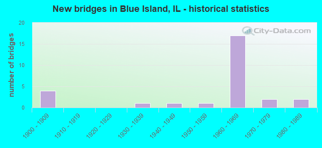
- New bridges - historical statistics
- 41900-1909
- 11930-1939
- 11940-1949
- 11950-1959
- 171960-1969
- 21970-1979
- 21980-1989

- Reconstructed bridges - Historical Statistics
- 11970-1979
- 31980-1989
- 61990-1999
- 22000-2009
- 12010-2019
- 12020-2022


- Bridge Condition - Deck
- 20.0%Good
- 60.0%Satisfactory
- 13.3%Fair
- 6.7%Serious

- Bridge Condition - Superstructure
- 33.3%Good
- 33.3%Satisfactory
- 13.3%Fair
- 6.7%Poor
- 13.3%Serious

- Bridge Condition - Substructure
- 53.3%Good
- 20.0%Satisfactory
- 20.0%Fair
- 6.7%Serious

- Bridge Condition - Channel
- 36.4%Very good
- 18.2%Good
- 18.2%Satisfactory
- 27.3%Fair

- Bridge Condition - Culverts
- 33.3%Good
- 66.7%Satisfactory
Find on map >> Show street view
Structure Number: 160064, Location: 0.5 M S 127TH (Lat: 41.654761, Lng: -87.661569), Route carried "on" structure: Interstate 57, Year Built: 1966, Year Reconstructed: 1989, Status: Open, Structure Length: 14.99m (49.18ft), Average Daily Traffic: 53,400 (year 2021), Truck Traffic: 6%, Average Future Daily Traffic: 71,379 (year 2032), Design Load: HS 20+Mod, Features Intersected: CAL SAG CHANNEL
Minimum Vertical Clearance: 30+ m (98+ ft), Kilometerpoint: 567.520, Lanes on structure: 3, Base Highway Network: Yes, Owner: State Highway Agency, Approaching Roadway Width: 16.5m (54.1ft), Navigation Control: Yes ( Vertical Clearance: 12.8m (42.0ft), Horizontal Clearance: 68.6m (225.1ft)), Material/Design: Steel continuous, Design/Construction: Stringer/Multi-beam, Number Of Spans In Main Unit: 3, Length of Maximum Span: 81.6m (267.7ft), Curb-To-Curb Width: 16.6m (54.5ft), Out-to-Out Width: 17.5m (57.4ft)
Condition: Deck: Satisfactory, Superstructure: Satisfactory, Substructure: Satisfactory, Channel: Very good, Operating Rating: 67.1 metric tons, Method Used To Determine Operating Rating: Load Factor (LF) rating reported by rating factor (RF) method using MS18 loading, Inventory Rating: 40.2 metric tons, Method Used To Determine Inventory Rating: Load Factor (LF) rating reported by rating factor (RF) method using MS18 loading, Structural Evaluation: Equal to present minimum criteria, Deck Geometry: Equal to present minimum criteria, Waterway Adequacy: Superior to present desirable criteria, Approach Roadway Alignment: Equal to present desirable criteria, Designated Inspection Frequency: Every 24 months, Inspection Date: April 2021, Deck Structure Type: Concrete Cast-file-Place, Wearing Surface/Protective System: Wearing Surface: Other
Find on map >> Show street view
Structure Number: 160065, Location: 0.5 M S 127TH (Lat: 41.654619, Lng: -87.661547), Route carried "on" structure: Interstate 57, Year Built: 1966, Year Reconstructed: 1989, Status: Open, Structure Length: 14.99m (49.18ft), Average Daily Traffic: 53,400 (year 2021), Truck Traffic: 6%, Average Future Daily Traffic: 71,379 (year 2032), Design Load: HS 20+Mod, Features Intersected: CAL SAG CHANNEL
Minimum Vertical Clearance: 30+ m (98+ ft), Kilometerpoint: 567.504, Lanes on structure: 3, Base Highway Network: Yes, Owner: State Highway Agency, Approaching Roadway Width: 17.7m (58.1ft), Navigation Control: Yes ( Vertical Clearance: 12.8m (42.0ft), Horizontal Clearance: 68.6m (225.1ft)), Material/Design: Steel continuous, Design/Construction: Stringer/Multi-beam, Number Of Spans In Main Unit: 3, Length of Maximum Span: 81.6m (267.7ft), Curb-To-Curb Width: 16.6m (54.5ft), Out-to-Out Width: 17.7m (58.1ft)
Condition: Deck: Satisfactory, Superstructure: Satisfactory, Substructure: Good, Channel: Very good, Operating Rating: 67.1 metric tons, Method Used To Determine Operating Rating: Load Factor (LF) rating reported by rating factor (RF) method using MS18 loading, Inventory Rating: 40.2 metric tons, Method Used To Determine Inventory Rating: Load Factor (LF) rating reported by rating factor (RF) method using MS18 loading, Structural Evaluation: Equal to present minimum criteria, Deck Geometry: Equal to present minimum criteria, Waterway Adequacy: Superior to present desirable criteria, Approach Roadway Alignment: Equal to present desirable criteria, Designated Inspection Frequency: Every 24 months, Inspection Date: April 2021, Deck Structure Type: Concrete Cast-file-Place, Wearing Surface/Protective System: Wearing Surface: Other
Find on map >> Show street view
Structure Number: 160066, Location: 2.5 NE ILL 83 (Lat: 41.658028, Lng: -87.662078), Route carried "on" structure: Interstate 57, Year Built: 1966, Year Reconstructed: 2002, Status: Open, Structure Length: 5.02m (16.47ft), Average Daily Traffic: 53,400 (year 2021), Truck Traffic: 6%, Average Future Daily Traffic: 71,379 (year 2032), Design Load: HS 20, Features Intersected: VERMONT ST
Minimum Vertical Clearance: 30+ m (98+ ft), Kilometerpoint: 567.890, Lanes on structure: 4, Lanes under structure: 4, Base Highway Network: Yes, Owner: State Highway Agency, Approaching Roadway Width: 19.8m (65.0ft), Skew: 1 degrees, Material/Design: Steel continuous, Design/Construction: Stringer/Multi-beam, Number Of Spans In Main Unit: 3, Length of Maximum Span: 21.3m (69.9ft), Curb-To-Curb Width: 19.8m (65.0ft), Out-to-Out Width: 20.7m (67.9ft)
Condition: Deck: Satisfactory, Superstructure: Good, Substructure: Good, Operating Rating: 83.3 metric tons, Method Used To Determine Operating Rating: Load Factor (LF) rating reported by rating factor (RF) method using MS18 loading, Inventory Rating: 49.9 metric tons, Method Used To Determine Inventory Rating: Load Factor (LF) rating reported by rating factor (RF) method using MS18 loading, Structural Evaluation: Better than present minimum criteria, Deck Geometry: Equal to present minimum criteria, Underclear: Better than present minimum criteria, Approach Roadway Alignment: Equal to present desirable criteria, Length Of Structure Improvement: 4.94m (16.21ft), Designated Inspection Frequency: Every 24 months, Inspection Date: Febuary 2020, Bridge Improvement Cost: $678,000, Roadway Improvement Cost: $68,000, Total Project Cost: $1,119,000, Deck Structure Type: Concrete Cast-file-Place, Wearing Surface/Protective System: Wearing Surface: Epoxy Overlay, Deck Protection: Epoxy Coated Reinforcing
Find on map >> Show street view
Structure Number: 160067, Location: 2.5 NE ILL 83 (Lat: 41.657886, Lng: -87.662056), Route carried "on" structure: Interstate 57, Year Built: 1966, Year Reconstructed: 2004, Status: Open, Structure Length: 5.02m (16.47ft), Average Daily Traffic: 53,400 (year 2021), Truck Traffic: 6%, Average Future Daily Traffic: 71,379 (year 2032), Design Load: HS 20, Features Intersected: VERMONT ST
Minimum Vertical Clearance: 30+ m (98+ ft), Kilometerpoint: 567.874, Lanes on structure: 3, Lanes under structure: 4, Base Highway Network: Yes, Owner: State Highway Agency, Approaching Roadway Width: 18.0m (59.1ft), Skew: 1 degrees, Material/Design: Steel continuous, Design/Construction: Stringer/Multi-beam, Number Of Spans In Main Unit: 3, Length of Maximum Span: 21.3m (69.9ft), Curb-To-Curb Width: 17.1m (56.1ft), Out-to-Out Width: 18.0m (59.1ft)
Condition: Deck: Satisfactory, Superstructure: Good, Substructure: Good, Operating Rating: 82.3 metric tons, Method Used To Determine Operating Rating: Load Factor (LF) rating reported by rating factor (RF) method using MS18 loading, Inventory Rating: 49.2 metric tons, Method Used To Determine Inventory Rating: Load Factor (LF) rating reported by rating factor (RF) method using MS18 loading, Structural Evaluation: Better than present minimum criteria, Deck Geometry: Equal to present minimum criteria, Underclear: High priority of corrective action, Approach Roadway Alignment: Equal to present desirable criteria, Length Of Structure Improvement: 5.18m (16.99ft), Designated Inspection Frequency: Every 24 months, Inspection Date: Febuary 2020, Bridge Improvement Cost: $820,000, Roadway Improvement Cost: $82,000, Total Project Cost: $1,230,000, Deck Structure Type: Concrete Cast-file-Place, Wearing Surface/Protective System: Deck Protection: Epoxy Coated Reinforcing
Find on map >> Show street view
Structure Number: 160295, Location: 0.5 N 138TH ST (Lat: 41.651961, Lng: -87.660494), Route carried "on" structure: Other road , Year Built: 1930, Year Reconstructed: 1995, Status: Open, Structure Length: 8.84m (29.00ft), Average Daily Traffic: 18,900 (year 2021), Truck Traffic: 4%, Average Future Daily Traffic: 16,068 (year 2032), Features Intersected: LITTLE CAL RIVER, Facility Carried by Structure: ASHLAND AVE
Minimum Vertical Clearance: 30+ m (98+ ft), Kilometerpoint: 2.639, Lanes on structure: 4, Base Highway Network: Yes, Owner: State Highway Agency, Approaching Roadway Width: 13.4m (44.0ft), Skew: 2 degrees, Material/Design: Steel continuous, Design/Construction: Stringer/Multi-beam, Number Of Spans In Main Unit: 5, Length of Maximum Span: 17.7m (58.1ft), Curb-To-Curb Width: 18.3m (60.0ft), Out-to-Out Width: 19.3m (63.3ft)
Condition: Deck: Good, Superstructure: Satisfactory, Substructure: Good, Channel: Good, Operating Rating: 74.5 metric tons, Method Used To Determine Operating Rating: Load Factor (LF) rating reported by rating factor (RF) method using MS18 loading, Inventory Rating: 44.7 metric tons, Method Used To Determine Inventory Rating: Load Factor (LF) rating reported by rating factor (RF) method using MS18 loading, Structural Evaluation: Equal to present minimum criteria, Deck Geometry: Somewhat better than minimum adequacy, Waterway Adequacy: Equal to present desirable criteria, Approach Roadway Alignment: Equal to present desirable criteria, Length Of Structure Improvement: 8.78m (28.81ft), Designated Inspection Frequency: Every 24 months, Other Special Inspection Frequency: Every 48 months, Inspection Date: January 2021, Other Special Inspection Date: January 2021, Bridge Improvement Cost: $970,000, Roadway Improvement Cost: $97,000, Total Project Cost: $1,601,000, Deck Structure Type: Concrete Cast-file-Place, Wearing Surface/Protective System: Deck Protection: Epoxy Coated Reinforcing
Find on map >> Show street view
Structure Number: 160776, Location: JUST E WESTERN (Lat: 41.655489, Lng: -87.678511), Route carried "on" structure: Other road , Year Built: 1967, Year Reconstructed: 2008, Status: Open, Structure Length: 2.47m (8.10ft), Average Daily Traffic: 5,100 (year 2014), Truck Traffic: 3%, Average Future Daily Traffic: 8,343 (year 2032), Design Load: HS 20, Features Intersected: VERMONT ST, Facility Carried by Structure: WESTERN AVE(GREGOR
Minimum Vertical Clearance: 30+ m (98+ ft), Kilometerpoint: 0.177, Lanes on structure: 3, Lanes under structure: 4, Base Highway Network: Yes, Owner: State Highway Agency, Approaching Roadway Width: 15.8m (51.8ft), Skew: 4 degrees, Material/Design: Prestressed concrete, Design/Construction: Box Beam or Girders - Multiple, Number Of Spans In Main Unit: 1, Length of Maximum Span: 23.8m (78.1ft), Curb or Sidewalk Widths: Left: 1.8m (5.9ft), Right: 1.8m (5.9ft), Curb-To-Curb Width: 16.3m (53.5ft), Out-to-Out Width: 21.6m (70.9ft)
Condition: Deck: Satisfactory, Superstructure: Fair, Substructure: Good, Operating Rating: 83.9 metric tons, Method Used To Determine Operating Rating: Load Factor (LF) rating reported by rating factor (RF) method using MS18 loading, Inventory Rating: 50.2 metric tons, Method Used To Determine Inventory Rating: Load Factor (LF) rating reported by rating factor (RF) method using MS18 loading, Structural Evaluation: Somewhat better than minimum adequacy, Deck Geometry: Better than present minimum criteria, Underclear: Meets minimum limits, Approach Roadway Alignment: Equal to present desirable criteria, Designated Inspection Frequency: Every 24 months, Inspection Date: Febuary 2021, Deck Structure Type: Concrete Cast-file-Place, Wearing Surface/Protective System: Wearing Surface: Integral Concrete, Deck Protection: Epoxy Coated Reinforcing
Find on map >> Show street view
Structure Number: 160777, Location: 1.5 M N IL 83 (Lat: 41.652897, Lng: -87.679892), Route carried "on" structure: Other road , Year Built: 1966, Year Reconstructed: 2020, Status: Open, Structure Length: 34.23m (112.30ft), Average Daily Traffic: 6,950 (year 2018), Truck Traffic: 10%, Average Future Daily Traffic: 8,446 (year 2032), Design Load: HS 20+Mod, Features Intersected: CAL SG CHNL&RR&BRDWY, Facility Carried by Structure: WESTERN AVE
Minimum Vertical Clearance: 5.49m (18.01ft), Kilometerpoint: 37.545, Lanes on structure: 4, Lanes under structure: 4, Base Highway Network: Yes, Owner: State Highway Agency, Approaching Roadway Width: 22.3m (73.2ft), Skew: 30 degrees, Navigation Control: Yes ( Vertical Clearance: 13.7m (44.9ft), Horizontal Clearance: 68.6m (225.1ft)), Material/Design: Steel, Design/Construction: Truss - Thru, Number Of Spans In Main Unit: 1, Number Of Approach Spans: 13, Length of Maximum Span: 74.9m (245.7ft), Curb or Sidewalk Widths: Left: 2.1m (6.9ft), Right: 2.1m (6.9ft), Curb-To-Curb Width: 16.2m (53.1ft), Out-to-Out Width: 20.7m (67.9ft)
Condition: Deck: Serious, Superstructure: Serious, Substructure: Serious, Channel: Very good, Operating Rating: 54.4 metric tons, Method Used To Determine Operating Rating: Load Factor (LF) rating reported by rating factor (RF) method using MS18 loading, Inventory Rating: 32.4 metric tons, Method Used To Determine Inventory Rating: Load Factor (LF) rating reported by rating factor (RF) method using MS18 loading, Structural Evaluation: High priority of corrective action, Deck Geometry: Meets minimum limits, Underclear: High priority of corrective action, Waterway Adequacy: Equal to present desirable criteria, Approach Roadway Alignment: Equal to present minimum criteria, Length Of Structure Improvement: 33.80m (110.89ft), Designated Inspection Frequency: Every 12 months, Critical Feature Inspection Frequency: Every 12 months, Inspection Date: March 2021, Critical Feature Inspection Date: March 2021, Bridge Improvement Cost: $5,605,000, Roadway Improvement Cost: $561,000, Total Project Cost: $8,408,000, Deck Structure Type: Concrete Cast-file-Place, Wearing Surface/Protective System: Wearing Surface: Latex Concrete
Find on map >> Show street view
Structure Number: 160908, Location: 0.5 M W I-57 (Lat: 41.662686, Lng: -87.675364), Route carried "on" structure: Other road , Year Built: 1957, Year Reconstructed: 2004, Status: Open, Structure Length: 32.54m (106.76ft), Average Daily Traffic: 27,200 (year 2018), Truck Traffic: 7%, Average Future Daily Traffic: 29,767 (year 2032), Features Intersected: RR - METRA, Facility Carried by Structure: 127TH ST BURR OAK
Minimum Vertical Clearance: 30+ m (98+ ft), Kilometerpoint: 24.204, Lanes on structure: 4, Base Highway Network: Yes, Owner: State Highway Agency, Approaching Roadway Width: 14.4m (47.2ft), Skew: 2 degrees, Material/Design: Steel continuous, Design/Construction: Stringer/Multi-beam, Number Of Spans In Main Unit: 7, Length of Maximum Span: 52.9m (173.6ft), Curb or Sidewalk Widths: Left: 1.7m (5.6ft), Right: 1.7m (5.6ft), Curb-To-Curb Width: 14.4m (47.2ft), Out-to-Out Width: 18.4m (60.4ft)
Condition: Deck: Satisfactory, Superstructure: Good, Substructure: Fair, Operating Rating: 77.4 metric tons, Method Used To Determine Operating Rating: Load Factor (LF) rating reported by rating factor (RF) method using MS18 loading, Inventory Rating: 46.7 metric tons, Method Used To Determine Inventory Rating: Load Factor (LF) rating reported by rating factor (RF) method using MS18 loading, Structural Evaluation: Somewhat better than minimum adequacy, Deck Geometry: High priority of replacement, Underclear: Equal to present minimum criteria, Approach Roadway Alignment: Equal to present desirable criteria, Length Of Structure Improvement: 45.57m (149.51ft), Designated Inspection Frequency: Every 24 months, Inspection Date: July 2021, Bridge Improvement Cost: $11,051,000, Roadway Improvement Cost: $1,105,000, Total Project Cost: $16,577,000, Deck Structure Type: Concrete Cast-file-Place, Wearing Surface/Protective System: Deck Protection: Epoxy Coated Reinforcing
Find on map >> Show street view
Structure Number: 160994, Location: 0.5 M W WESTERN AVE (Lat: 41.640764, Lng: -87.685492), Route carried "on" structure: Other road , Year Built: 1960, Year Reconstructed: 2004, Status: Open, Structure Length: 27.95m (91.70ft), Average Daily Traffic: 5,550 (year 2018), Truck Traffic: 7%, Average Future Daily Traffic: 9,476 (year 2032), Features Intersected: RR - CSX & IHB, Facility Carried by Structure: 139TH ST
Minimum Vertical Clearance: 30+ m (98+ ft), Kilometerpoint: 2.752, Lanes on structure: 2, Owner: State Highway Agency, Approaching Roadway Width: 8.5m (27.9ft), Skew: 1 degrees, Material/Design: Steel continuous, Design/Construction: Stringer/Multi-beam, Number Of Spans In Main Unit: 18, Length of Maximum Span: 20.5m (67.3ft), Curb or Sidewalk Widths: Left: 1.5m (4.9ft), Right: 1.5m (4.9ft), Curb-To-Curb Width: 8.5m (27.9ft), Out-to-Out Width: 12.4m (40.7ft)
Condition: Deck: Good, Superstructure: Fair, Substructure: Good, Operating Rating: 66.7 metric tons, Method Used To Determine Operating Rating: Load Factor (LF) rating reported by rating factor (RF) method using MS18 loading, Inventory Rating: 39.9 metric tons, Method Used To Determine Inventory Rating: Load Factor (LF) rating reported by rating factor (RF) method using MS18 loading, Structural Evaluation: Somewhat better than minimum adequacy, Deck Geometry: Meets minimum limits, Underclear: Superior to present desirable criteria, Approach Roadway Alignment: Equal to present desirable criteria, Length Of Structure Improvement: 27.74m (91.01ft), Designated Inspection Frequency: Every 24 months, Inspection Date: November 2020, Bridge Improvement Cost: $4,349,000, Roadway Improvement Cost: $435,000, Total Project Cost: $6,524,000, Deck Structure Type: Concrete Cast-file-Place, Wearing Surface/Protective System: Deck Protection: Epoxy Coated Reinforcing
Find on map >> Show street view
Structure Number: 161008, Location: 2 M E IL 50 (Lat: 41.662356, Lng: -87.701972), Route carried "on" structure: Other road , Year Built: 1968, Year Reconstructed: 1983, Status: Open, Structure Length: 1.68m (5.51ft), Average Daily Traffic: 21,200 (year 2021), Truck Traffic: 8%, Average Future Daily Traffic: 28,737 (year 2032), Design Load: HS 20, Features Intersected: STONY CREEK, Facility Carried by Structure: 127TH ST BURR OAK
Minimum Vertical Clearance: 30+ m (98+ ft), Kilometerpoint: 21.983, Lanes on structure: 5, Base Highway Network: Yes, Owner: State Highway Agency, Approaching Roadway Width: 19.2m (63.0ft), Skew: 24 degrees, Material/Design: Concrete continuous, Design/Construction: Culvert, Number Of Spans In Main Unit: 3, Length of Maximum Span: 6.8m (22.3ft), Curb or Sidewalk Widths: Left: 0.0m, Right: 0.9m (3.0ft)
Condition: Channel: Fair, Culverts: Satisfactory, Operating Rating: 91.7 metric tons, Method Used To Determine Operating Rating: Load Factor (LF) rating reported by rating factor (RF) method using MS18 loading, Inventory Rating: 54.8 metric tons, Method Used To Determine Inventory Rating: Load Factor (LF) rating reported by rating factor (RF) method using MS18 loading, Structural Evaluation: Equal to present minimum criteria, Waterway Adequacy: Equal to present desirable criteria, Approach Roadway Alignment: Equal to present desirable criteria, Designated Inspection Frequency: Every 24 months, Inspection Date: October 2020, Deck Structure Type: Other
Find on map >> Show street view
Structure Number: 162033, Location: 3.6 M SW IL 1 (Lat: 41.670303, Lng: -87.662758), Route carried "on" structure: Other road , Year Built: 1966, Year Reconstructed: 2001, Status: Open, Structure Length: 7.21m (23.65ft), Average Daily Traffic: 3,175 (year 2018), Truck Traffic: 8%, Average Future Daily Traffic: 3,451 (year 2032), Design Load: HS 20, Features Intersected: I- 57, Facility Carried by Structure: 123RD ST
Minimum Vertical Clearance: 30+ m (98+ ft), Kilometerpoint: 0.016, Lanes on structure: 2, Lanes under structure: 6, Owner: State Highway Agency, Approaching Roadway Width: 8.4m (27.6ft), Material/Design: Steel continuous, Design/Construction: Stringer/Multi-beam, Number Of Spans In Main Unit: 4, Length of Maximum Span: 21.6m (70.9ft), Curb or Sidewalk Widths: Left: 1.8m (5.9ft), Right: 0.0m, Curb-To-Curb Width: 8.4m (27.6ft), Out-to-Out Width: 11.0m (36.1ft)
Condition: Deck: Satisfactory, Superstructure: Satisfactory, Substructure: Satisfactory, Operating Rating: 78.1 metric tons, Method Used To Determine Operating Rating: Load Factor (LF) rating reported by rating factor (RF) method using MS18 loading, Inventory Rating: 47.0 metric tons, Method Used To Determine Inventory Rating: Load Factor (LF) rating reported by rating factor (RF) method using MS18 loading, Structural Evaluation: Equal to present minimum criteria, Deck Geometry: High priority of corrective action, Underclear: Meets minimum limits, Approach Roadway Alignment: Equal to present desirable criteria, Length Of Structure Improvement: 8.05m (26.41ft), Designated Inspection Frequency: Every 24 months, Inspection Date: Febuary 2022, Bridge Improvement Cost: $1,331,000, Roadway Improvement Cost: $133,000, Total Project Cost: $1,997,000, Deck Structure Type: Concrete Cast-file-Place, Wearing Surface/Protective System: Deck Protection: Epoxy Coated Reinforcing
Find on map >> Show street view
Structure Number: 162413, Location: 1.4 M S of 127th St (Lat: 41.643683, Lng: -87.679956), Route carried "on" structure: Other road , Year Built: 1980, Status: Open, Structure Length: 0.97m (3.18ft), Average Daily Traffic: 6,950 (year 2018), Truck Traffic: 10%, Average Future Daily Traffic: 14,000 (year 2040), Design Load: HS 20, Features Intersected: MIDLOTHIAN CR, Facility Carried by Structure: WESTERN AVE
Minimum Vertical Clearance: 30+ m (98+ ft), Kilometerpoint: 38.607, Lanes on structure: 4, Base Highway Network: Yes, Owner: State Highway Agency, Approaching Roadway Width: 15.8m (51.8ft), Material/Design: Concrete, Design/Construction: Culvert, Number Of Spans In Main Unit: 3, Length of Maximum Span: 3.0m (9.8ft), Curb or Sidewalk Widths: Left: 0.0m, Right: 1.5m (4.9ft)
Condition: Channel: Satisfactory, Culverts: Satisfactory, Operating Rating: 43.4 metric tons, Method Used To Determine Operating Rating: Load Factor (LF) rating reported by rating factor (RF) method using MS18 loading, Inventory Rating: 25.9 metric tons, Method Used To Determine Inventory Rating: Load Factor (LF) rating reported by rating factor (RF) method using MS18 loading, Structural Evaluation: Equal to present minimum criteria, Waterway Adequacy: Equal to present desirable criteria, Approach Roadway Alignment: Equal to present desirable criteria, Designated Inspection Frequency: Every 24 months, Inspection Date: November 2020, Deck Structure Type: Other
Find on map >> Show street view
Structure Number: 16243, Location: 0.1M S 127TH ST (Lat: 41.660414, Lng: -87.699692), Route carried "on" structure: Other road , Year Built: 1972, Status: Open, Structure Length: 47.56m (156.04ft), Average Daily Traffic: 13,100 (year 2018), Truck Traffic: 5%, Average Future Daily Traffic: 13,905 (year 2032), Design Load: HS 20, Features Intersected: RR - CSXT & WIRETON, Facility Carried by Structure: KEDZIE AVE
Minimum Vertical Clearance: 30+ m (98+ ft), Kilometerpoint: 37.239, Lanes on structure: 4, Lanes under structure: 2, Base Highway Network: Yes, Owner: State Highway Agency, Approaching Roadway Width: 15.8m (51.8ft), Skew: 33 degrees, Material/Design: Steel continuous, Design/Construction: Stringer/Multi-beam, Number Of Spans In Main Unit: 19, Length of Maximum Span: 29.7m (97.4ft), Curb or Sidewalk Widths: Left: 1.5m (4.9ft), Right: 1.5m (4.9ft), Curb-To-Curb Width: 15.8m (51.8ft), Out-to-Out Width: 20.7m (67.9ft)
Condition: Deck: Fair, Superstructure: Serious, Substructure: Fair, Operating Rating: 59.0 metric tons, Method Used To Determine Operating Rating: Allowable Stress (AS) rating reported by rating factor (RF) method using MS18 loading, Inventory Rating: 35.0 metric tons, Method Used To Determine Inventory Rating: Allowable Stress (AS) rating reported by rating factor (RF) method using MS18 loading, Structural Evaluation: High priority of corrective action, Deck Geometry: Meets minimum limits, Underclear: Somewhat better than minimum adequacy, Approach Roadway Alignment: Better than present minimum criteria, Designated Inspection Frequency: Every 12 months, Inspection Date: August 2021, Deck Structure Type: Concrete Cast-file-Place, Wearing Surface/Protective System: Wearing Surface: Latex Concrete
Find on map >> Show street view
Structure Number: 16281, Location: 0.05 M S 127TH ST (Lat: 41.661433, Lng: -87.699739), Route carried "on" structure: Other road , Year Built: 1969, Status: Open, Structure Length: 1.57m (5.15ft), Average Daily Traffic: 13,100 (year 2018), Truck Traffic: 5%, Average Future Daily Traffic: 13,905 (year 2032), Features Intersected: STONEY CREEK, Facility Carried by Structure: KEDZIE AVE
Minimum Vertical Clearance: 30+ m (98+ ft), Kilometerpoint: 36.982, Lanes on structure: 4, Base Highway Network: Yes, Owner: State Highway Agency, Approaching Roadway Width: 14.6m (47.9ft), Skew: 3 degrees, Material/Design: Concrete continuous, Design/Construction: Culvert, Number Of Spans In Main Unit: 3, Length of Maximum Span: 4.1m (13.5ft)
Condition: Channel: Fair, Culverts: Good, Operating Rating: 44.1 metric tons, Method Used To Determine Operating Rating: Load Factor (LF) rating reported by rating factor (RF) method using MS18 loading, Inventory Rating: 32.4 metric tons, Method Used To Determine Inventory Rating: Load Factor (LF) rating reported by rating factor (RF) method using MS18 loading, Structural Evaluation: Better than present minimum criteria, Waterway Adequacy: Better than present minimum criteria, Approach Roadway Alignment: Equal to present desirable criteria, Designated Inspection Frequency: Every 24 months, Inspection Date: May 2021
Find on map >> Show street view
Structure Number: 163099, Location: 0.37 E DIXIE HY P24 (Lat: 41.645536, Lng: -87.672464), Route carried "on" structure: City street , Year Built: 1948, Year Reconstructed: 1993, Status: Open, Structure Length: 1.14m (3.74ft), Average Daily Traffic: 900 (year 2018), Truck Traffic: 19%, Average Future Daily Traffic: 3,760 (year 2032), Design Load: HS 20, Features Intersected: CALUMET SLOUGH, Facility Carried by Structure: THORNTON ROAD
Minimum Vertical Clearance: 30+ m (98+ ft), Kilometerpoint: 0.676, Lanes on structure: 2, Owner: County Highway Agency, Approaching Roadway Width: 12.2m (40.0ft), Material/Design: Concrete, Design/Construction: Tee Beam, Number Of Spans In Main Unit: 1, Length of Maximum Span: 11.0m (36.1ft), Curb or Sidewalk Widths: Left: 1.5m (4.9ft), Right: 1.5m (4.9ft), Curb-To-Curb Width: 13.4m (44.0ft), Out-to-Out Width: 17.1m (56.1ft)
Condition: Deck: Satisfactory, Superstructure: Good, Substructure: Good, Channel: Fair, Operating Rating: 76.8 metric tons, Method Used To Determine Operating Rating: Load Factor (LF) rating reported by rating factor (RF) method using MS18 loading, Inventory Rating: 46.0 metric tons, Method Used To Determine Inventory Rating: Load Factor (LF) rating reported by rating factor (RF) method using MS18 loading, Structural Evaluation: Better than present minimum criteria, Deck Geometry: Superior to present desirable criteria, Waterway Adequacy: Equal to present desirable criteria, Approach Roadway Alignment: Equal to present desirable criteria, Designated Inspection Frequency: Every 24 months, Inspection Date: March 2021, Deck Structure Type: Concrete Cast-file-Place, Wearing Surface/Protective System: Deck Protection: Epoxy Coated Reinforcing
Find on map >> Show street view
Structure Number: 16321, Location: 0.2 N BROADWAY P26 (Lat: 41.652350, Lng: -87.692036), Route carried "on" structure: Other road , Year Built: 1969, Year Reconstructed: 2014, Status: Open, Structure Length: 11.09m (36.38ft), Average Daily Traffic: 10,350 (year 2018), Truck Traffic: 5%, Average Future Daily Traffic: 7,313 (year 2032), Design Load: HS 20+Mod, Features Intersected: CAL SAG CHANNEL, Facility Carried by Structure: FRANCISCO AVE
Minimum Vertical Clearance: 5.33m (17.49ft), Kilometerpoint: 0.354, Lanes on structure: 2, Owner: County Highway Agency, Approaching Roadway Width: 8.5m (27.9ft), Navigation Control: Yes ( Vertical Clearance: 7.0m (23.0ft), Horizontal Clearance: 68.6m (225.1ft)), Material/Design: Steel, Design/Construction: Truss - Thru, Number Of Spans In Main Unit: 1, Number Of Approach Spans: 4, Length of Maximum Span: 76.8m (252.0ft), Curb or Sidewalk Widths: Left: 1.5m (4.9ft), Right: 1.5m (4.9ft), Curb-To-Curb Width: 8.5m (27.9ft), Out-to-Out Width: 13.7m (44.9ft)
Condition: Deck: Satisfactory, Superstructure: Poor, Substructure: Satisfactory, Channel: Good, Operating Rating: 32.7 metric tons, Method Used To Determine Operating Rating: Load Factor (LF) rating reported by rating factor (RF) method using MS18 loading, Inventory Rating: 19.4 metric tons, Method Used To Determine Inventory Rating: Load Factor (LF) rating reported by rating factor (RF) method using MS18 loading, Structural Evaluation: Meets minimum limits, Deck Geometry: Meets minimum limits, Waterway Adequacy: Superior to present desirable criteria, Approach Roadway Alignment: Equal to present desirable criteria, Designated Inspection Frequency: Every 24 months, Critical Feature Inspection Frequency: Every 12 months, Underwater Inspection Frequency: Every 60 months, Inspection Date: April 2021, Critical Feature Inspection Date: April 2021, Underwater Inspection Date: August 2020, Deck Structure Type: Concrete Cast-file-Place, Wearing Surface/Protective System: Wearing Surface: Latex Concrete, Deck Protection: Cathodic Protection
Find on map >> Show street view
Structure Number: 165005, Location: 0.2M.S.VERMONT ST P4 (Lat: 41.653239, Lng: -87.670189), Route carried "on" structure: City street , Year Built: 1964, Year Reconstructed: 2016, Status: Open, Structure Length: 11.31m (37.11ft), Average Daily Traffic: 2,550 (year 2018), Truck Traffic: 6%, Average Future Daily Traffic: 1,648 (year 2032), Design Load: HS 20, Features Intersected: CAL SAG CHANNEL, Facility Carried by Structure: DIVISION ST
Minimum Vertical Clearance: 4.88m (16.01ft), Kilometerpoint: 1.046, Lanes on structure: 2, Owner: City or Municipal Highway Agency, Approaching Roadway Width: 9.1m (29.9ft), Navigation Control: Yes ( Vertical Clearance: 7.6m (24.9ft), Horizontal Clearance: 68.6m (225.1ft)), Material/Design: Steel, Design/Construction: Truss - Thru, Number Of Spans In Main Unit: 1, Number Of Approach Spans: 3, Length of Maximum Span: 88.3m (289.7ft), Curb or Sidewalk Widths: Left: 1.6m (5.2ft), Right: 1.6m (5.2ft), Curb-To-Curb Width: 9.1m (29.9ft), Out-to-Out Width: 14.6m (47.9ft)
Condition: Deck: Good, Superstructure: Good, Substructure: Good, Channel: Very good, Operating Rating: 59.3 metric tons, Method Used To Determine Operating Rating: Load Factor (LF) rating reported by rating factor (RF) method using MS18 loading, Inventory Rating: 35.3 metric tons, Method Used To Determine Inventory Rating: Load Factor (LF) rating reported by rating factor (RF) method using MS18 loading, Structural Evaluation: Better than present minimum criteria, Deck Geometry: Meets minimum limits, Waterway Adequacy: Equal to present desirable criteria, Approach Roadway Alignment: Better than present minimum criteria, Length Of Structure Improvement: 11.31m (37.11ft), Designated Inspection Frequency: Every 24 months, Critical Feature Inspection Frequency: Every 24 months, Inspection Date: August 2020, Critical Feature Inspection Date: August 2020, Bridge Improvement Cost: $855,000, Roadway Improvement Cost: $86,000, Total Project Cost: $1,283,000, Deck Structure Type: Concrete Cast-file-Place, Wearing Surface/Protective System: Deck Protection: Epoxy Coated Reinforcing
Find on map >> Show street view
Structure Number: 166801, Location: 0.1 M S 136TH P24 (Lat: 41.644644, Lng: -87.675136), Route carried "on" structure: City street , Year Built: 1963, Status: Open, Structure Length: 0.98m (3.22ft), Average Daily Traffic: 800 (year 2018), Truck Traffic: 16%, Average Future Daily Traffic: 1,597 (year 2032), Design Load: HS 15, Features Intersected: CAL SLOUGH, Facility Carried by Structure: CHATHAM ST
Minimum Vertical Clearance: 30+ m (98+ ft), Kilometerpoint: 1.207, Lanes on structure: 2, Owner: City or Municipal Highway Agency, Approaching Roadway Width: 10.4m (34.1ft), Material/Design: Concrete, Design/Construction: Slab, Number Of Spans In Main Unit: 1, Length of Maximum Span: 9.1m (29.9ft), Curb or Sidewalk Widths: Left: 1.5m (4.9ft), Right: 1.5m (4.9ft), Curb-To-Curb Width: 11.0m (36.1ft), Out-to-Out Width: 14.3m (46.9ft)
Condition: Deck: Fair, Superstructure: Satisfactory, Substructure: Fair, Channel: Satisfactory, Operating Rating: 40.5 metric tons, Method Used To Determine Operating Rating: Field evaluation and documented engineering judgment, Inventory Rating: 24.3 metric tons, Method Used To Determine Inventory Rating: Field evaluation and documented engineering judgment, Structural Evaluation: Somewhat better than minimum adequacy, Deck Geometry: Better than present minimum criteria, Waterway Adequacy: Better than present minimum criteria, Approach Roadway Alignment: Equal to present desirable criteria, Designated Inspection Frequency: Every 24 months, Inspection Date: June 2021, Deck Structure Type: Concrete Cast-file-Place
Find on map >> Show street view
Structure Number: 160062, Location: 0.75 M S 127TH (Lat: 41.652481, Lng: -87.661311), Route carried "under" structure: Other road , Year Built: 1967, Structure Length: 0. m, Average Daily Traffic: 4,700 (year 2018), Truck Traffic: 4%, Features Intersected: LITTLE CAL RIV,BROAD, Facility Carried by Structure: I- 57 SB
Minimum Vertical Clearance: 7.14m (23.43ft), Kilometerpoint: 16.157, Lanes on structure: 3, Lanes under structure: 4, Material/Design: Steel continuous, Design/Construction: Stringer/Multi-beam, Length of Maximum Span: 36.6m (120.1ft)
Find on map >> Show street view
Structure Number: 160063, Location: 0.75 M S 127TH (Lat: 41.652544, Lng: -87.661047), Route carried "under" structure: Other road , Year Built: 1967, Structure Length: 0. m, Average Daily Traffic: 4,700 (year 2018), Truck Traffic: 4%, Features Intersected: LITTLE CAL RIV,BROAD, Facility Carried by Structure: I- 57 NB
Minimum Vertical Clearance: 7.09m (23.26ft), Kilometerpoint: 16.190, Lanes on structure: 3, Lanes under structure: 4, Material/Design: Steel continuous, Design/Construction: Stringer/Multi-beam, Length of Maximum Span: 36.6m (120.1ft)
Find on map >> Show street view
Structure Number: 160434, Location: 0.1 M W WESTERN P26 (Lat: 41.650444, Lng: -87.682967), Route carried "under" structure: Other road , Year Built: 1900, Structure Length: 0. m, Average Daily Traffic: 4,700 (year 2018), Truck Traffic: 4%, Features Intersected: BROADWAY, Facility Carried by Structure: CRI&P RR(WEST)
Minimum Vertical Clearance: 4.32m (14.17ft), Kilometerpoint: 14.339, Lanes under structure: 2, Material/Design: Concrete, Length of Maximum Span: 28.0m (91.9ft)
Find on map >> Show street view
Structure Number: 160435, Location: 0.09 W WESTERN P26 (Lat: 41.650450, Lng: -87.682767), Route carried "under" structure: Other road , Year Built: 1900, Structure Length: 0. m, Average Daily Traffic: 4,700 (year 2018), Truck Traffic: 4%, Features Intersected: BROADWAY, Facility Carried by Structure: CRI&P RR(EAST)
Minimum Vertical Clearance: 4.32m (14.17ft), Kilometerpoint: 14.355, Lanes under structure: 2, Material/Design: Concrete, Length of Maximum Span: 28.0m (91.9ft)
Find on map >> Show street view
Structure Number: 160776, Location: JUST E WESTERN (Lat: 41.655489, Lng: -87.678511), Route carried "under" structure: Other road , Year Built: 1967, Structure Length: 0. m, Average Daily Traffic: 8,900 (year 2021), Truck Traffic: 4%, Features Intersected: VERMONT ST, Facility Carried by Structure: WESTERN AVE(GREGOR
Minimum Vertical Clearance: 5.49m (18.01ft), Kilometerpoint: 1.062, Lanes on structure: 3, Lanes under structure: 4, Material/Design: Prestressed concrete, Design/Construction: Box Beam or Girders - Multiple, Length of Maximum Span: 23.8m (78.1ft)
Find on map >> Show street view
Structure Number: 160777, Location: 1.5 M N IL 83 (Lat: 41.650489, Lng: -87.680111), Route carried "under" structure: Other road , Year Built: 1966, Structure Length: 0. m, Average Daily Traffic: 4,700 (year 2018), Truck Traffic: 4%, Features Intersected: CAL SG CHNL&RR&BRDWY, Facility Carried by Structure: WESTERN AVE
Minimum Vertical Clearance: 5.05m (16.57ft), Kilometerpoint: 14.580, Lanes on structure: 4, Lanes under structure: 4, Material/Design: Steel, Design/Construction: Truss - Thru, Length of Maximum Span: 74.9m (245.7ft)
Find on map >> Show street view
Structure Number: 16243, Location: 0.1M S 127TH ST (Lat: 41.660350, Lng: -87.699689), Route carried "under" structure: Other road , Year Built: 1972, Structure Length: 0. m, Average Daily Traffic: 6,800 (year 2021), Truck Traffic: 8%, Features Intersected: RR - CSXT & WIRETON, Facility Carried by Structure: KEDZIE AVE
Minimum Vertical Clearance: 4.62m (15.16ft), Kilometerpoint: 0.338, Lanes on structure: 4, Lanes under structure: 2, Material/Design: Steel continuous, Design/Construction: Stringer/Multi-beam, Length of Maximum Span: 29.7m (97.4ft)
Find on map >> Show street view
Structure Number: 162511, Location: 0.35 W KEDZIE AVE (Lat: 41.662258, Lng: -87.708083), Route carried "under" structure: Other road , Year Built: 1983, Structure Length: 0. m, Average Daily Traffic: 25,700 (year 2021), Truck Traffic: 8%, Features Intersected: 127TH ST, Facility Carried by Structure: RR - CSXT
Minimum Vertical Clearance: 5.03m (16.50ft), Kilometerpoint: 21.420, Lanes under structure: 4, Material/Design: Steel, Design/Construction: Girder and Floorbeam System, Length of Maximum Span: 28.3m (92.8ft)
Find on map >> Show street view
Structure Number: 169944, Location: 0.45 M W WESTERN P26 (Lat: 41.655294, Lng: -87.688300), Route carried "under" structure: Other road , Year Built: 1900, Structure Length: 0. m, Average Daily Traffic: 10,250 (year 2021), Truck Traffic: 4%, Features Intersected: VERMONT ST, Facility Carried by Structure: GT RR (W)
Minimum Vertical Clearance: 4.39m (14.40ft), Kilometerpoint: 0.241, Lanes under structure: 4, Material/Design: Steel, Design/Construction: Girder and Floorbeam System, Length of Maximum Span: 15.2m (49.9ft)
Find on map >> Show street view
Structure Number: 169945, Location: 0.44 M W WESTERN P26 (Lat: 41.655308, Lng: -87.687736), Route carried "under" structure: Other road , Year Built: 1900, Structure Length: 0. m, Average Daily Traffic: 10,250 (year 2021), Truck Traffic: 4%, Features Intersected: VERMONT ST, Facility Carried by Structure: B&O RR (E)
Minimum Vertical Clearance: 4.42m (14.50ft), Kilometerpoint: 0.290, Lanes under structure: 4, Material/Design: Steel, Design/Construction: Girder and Floorbeam System, Length of Maximum Span: 15.2m (49.9ft)