Bridge Statistics for Blacksburg, Virginia (VA)
Condition, Traffic, Stress, Structural Evaluation, Project Costs
- National Bridge Inventory (NBI) Statistics
- 23Number of bridges
- 413ft / 126mTotal length
- $10,554,000Total costs
- 61,990Total average daily traffic
- 3,198Total average daily truck traffic
- National Bridge Inventory (NBI) Registered Bridges for Blacksburg
- No street view available for this location
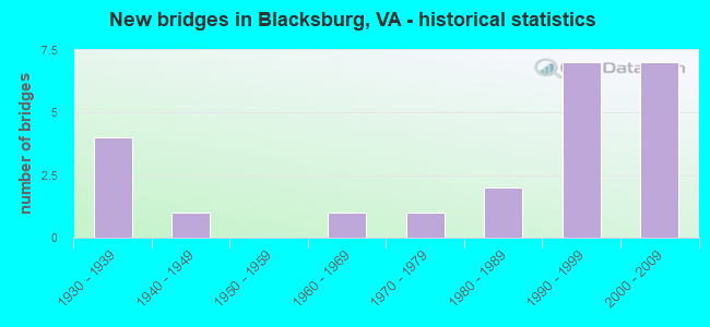
- New bridges - historical statistics
- 41930-1939
- 11940-1949
- 11960-1969
- 11970-1979
- 21980-1989
- 71990-1999
- 72000-2009


- Bridge Condition - Deck
- 7.1%Excellent
- 85.7%Good
- 7.1%Fair

- Bridge Condition - Superstructure
- 7.1%Excellent
- 78.6%Good
- 7.1%Satisfactory
- 7.1%Fair

- Bridge Condition - Substructure
- 7.1%Excellent
- 57.1%Good
- 35.7%Satisfactory

- Bridge Condition - Channel
- 33.3%Very good
- 40.0%Good
- 26.7%Satisfactory

- Bridge Condition - Culverts
- 60.0%Good
- 20.0%Satisfactory
- 20.0%Fair
Find on map >> Show street view
Structure Number: 8315, Location: 3.10-CraigCo.;1.00-Rte460 (Lat: 37.301233, Lng: -80.489911), Route carried "on" structure: State highway 42, Year Built: 1932, Status: Open, Structure Length: 0.73m (2.40ft), Average Daily Traffic: 1,453 (year 2020), Truck Traffic: 2%, Average Future Daily Traffic: 1,598 (year 2040), Features Intersected: Br. Sinking Creek
Minimum Vertical Clearance: 30+ m (98+ ft), Kilometerpoint: 130.274, Lanes on structure: 2, Owner: State Highway Agency, Approaching Roadway Width: 6.1m (20.0ft), Skew: 3 degrees, Material/Design: Concrete, Design/Construction: Culvert, Number Of Spans In Main Unit: 2, Length of Maximum Span: 3.0m (9.8ft)
Condition: Channel: Good, Culverts: Good, Operating Rating: 32.7 metric tons, Method Used To Determine Operating Rating: Field evaluation and documented engineering judgment, Inventory Rating: 32.7 metric tons, Method Used To Determine Inventory Rating: Field evaluation and documented engineering judgment, Structural Evaluation: Better than present minimum criteria, Waterway Adequacy: Equal to present minimum criteria, Approach Roadway Alignment: Equal to present desirable criteria, Designated Inspection Frequency: Every 24 months, Inspection Date: March 2021
Find on map >> Show street view
Structure Number: 8317, Location: 2.87-CraigCo;1.25-Rte460 (Lat: 37.303319, Lng: -80.486597), Route carried "on" structure: State highway 42, Year Built: 1941, Year Reconstructed: 2003, Status: Open, Structure Length: 2.59m (8.50ft), Average Daily Traffic: 1,453 (year 2020), Truck Traffic: 2%, Average Future Daily Traffic: 1,598 (year 2040), Design Load: HS 20, Features Intersected: Sinking Creek
Minimum Vertical Clearance: 30+ m (98+ ft), Kilometerpoint: 130.625, Lanes on structure: 2, Owner: State Highway Agency, Approaching Roadway Width: 6.1m (20.0ft), Material/Design: Prestressed concrete, Design/Construction: Box Beam or Girders - Multiple, Number Of Spans In Main Unit: 2, Length of Maximum Span: 12.7m (41.7ft), Curb or Sidewalk Widths: Left: 0.3m (1.0ft), Right: 0.3m (1.0ft), Curb-To-Curb Width: 8.6m (28.2ft), Out-to-Out Width: 9.4m (30.8ft)
Condition: Deck: Good, Superstructure: Good, Substructure: Good, Channel: Satisfactory, Operating Rating: 68.0 metric tons, Method Used To Determine Operating Rating: Load and Resistance Factor (LRFR), Inventory Rating: 50.8 metric tons, Method Used To Determine Inventory Rating: Load and Resistance Factor (LRFR), Structural Evaluation: Better than present minimum criteria, Deck Geometry: Somewhat better than minimum adequacy, Waterway Adequacy: Better than present minimum criteria, Approach Roadway Alignment: Equal to present desirable criteria, Length Of Structure Improvement: 3.05m (10.01ft), Designated Inspection Frequency: Every 24 months, Inspection Date: October 2021, Bridge Improvement Cost: $21,000, Roadway Improvement Cost: $4,000, Total Project Cost: $30,000 ( Estimate for 2017), Deck Structure Type: Other, Wearing Surface/Protective System: Wearing Surface: Bituminous
Find on map >> Show street view
Structure Number: 12193, Location: 0.40 Rt 641; 0.50 Rt 723 (Lat: 37.189803, Lng: -80.358464), Route carried "on" structure: County highway 603, Year Built: 1986, Status: Open, Structure Length: 4.39m (14.40ft), Average Daily Traffic: 1,272 (year 2020), Truck Traffic: 9%, Average Future Daily Traffic: 1,399 (year 2040), Features Intersected: Cedar Run
Minimum Vertical Clearance: 30+ m (98+ ft), Kilometerpoint: 3.910, Lanes on structure: 2, Owner: State Highway Agency, Approaching Roadway Width: 6.4m (21.0ft), Skew: 4 degrees, Material/Design: Concrete, Design/Construction: Tee Beam, Number Of Spans In Main Unit: 3, Length of Maximum Span: 14.6m (47.9ft), Curb-To-Curb Width: 7.9m (25.9ft), Out-to-Out Width: 8.9m (29.2ft)
Condition: Deck: Good, Superstructure: Good, Substructure: Good, Channel: Very good, Operating Rating: 89.8 metric tons, Method Used To Determine Operating Rating: Load and Resistance Factor (LRFR), Inventory Rating: 79.8 metric tons, Method Used To Determine Inventory Rating: Load and Resistance Factor (LRFR), Structural Evaluation: Better than present minimum criteria, Deck Geometry: Meets minimum limits, Waterway Adequacy: Better than present minimum criteria, Approach Roadway Alignment: Equal to present minimum criteria, Length Of Structure Improvement: 4.39m (14.40ft), Designated Inspection Frequency: Every 24 months, Inspection Date: September 2020, Bridge Improvement Cost: $1,440,000, Roadway Improvement Cost: $504,000, Total Project Cost: $4,680,000 ( Estimate for 2018), Deck Structure Type: Concrete Cast-file-Place, Wearing Surface/Protective System: Deck Protection: Epoxy Coated Reinforcing
Find on map >> Show street view
Structure Number: 12195, Location: 0.00 Rt 641; 3.30 Rt 821 (Lat: 37.186669, Lng: -80.352764), Route carried "on" structure: County highway 603, Year Built: 1968, Status: Open, Structure Length: 2.44m (8.01ft), Average Daily Traffic: 862 (year 2020), Truck Traffic: 9%, Average Future Daily Traffic: 948 (year 2040), Design Load: HS 20+Mod, Features Intersected: North Fork Roanoke River
Minimum Vertical Clearance: 30+ m (98+ ft), Kilometerpoint: 4.553, Lanes on structure: 2, Owner: State Highway Agency, Approaching Roadway Width: 6.7m (22.0ft), Skew: 1 degrees, Material/Design: Steel, Design/Construction: Stringer/Multi-beam, Number Of Spans In Main Unit: 1, Length of Maximum Span: 24.4m (80.1ft), Curb or Sidewalk Widths: Left: 0.2m (0.7ft), Right: 0.2m (0.7ft), Curb-To-Curb Width: 8.7m (28.5ft), Out-to-Out Width: 9.8m (32.2ft)
Condition: Deck: Good, Superstructure: Satisfactory, Substructure: Satisfactory, Channel: Good, Operating Rating: 62.6 metric tons, Method Used To Determine Operating Rating: Load and Resistance Factor (LRFR), Inventory Rating: 48.1 metric tons, Method Used To Determine Inventory Rating: Load and Resistance Factor (LRFR), Structural Evaluation: Equal to present minimum criteria, Deck Geometry: Somewhat better than minimum adequacy, Waterway Adequacy: Equal to present minimum criteria, Approach Roadway Alignment: Equal to present minimum criteria, Designated Inspection Frequency: Every 24 months, Inspection Date: August 2021, Deck Structure Type: Concrete Cast-file-Place
Find on map >> Show street view
Structure Number: 12323, Location: 0.30 Rt 723; 1.80 D End (Lat: 37.204711, Lng: -80.358889), Route carried "on" structure: County highway 712, Year Built: 1932, Year Reconstructed: 2021, Status: Open, Structure Length: 1.22m (4.00ft), Average Daily Traffic: 55 (year 2020), Average Future Daily Traffic: 77 (year 2040), Design Load: HS 20, Features Intersected: N Fork Rke River
Minimum Vertical Clearance: 30+ m (98+ ft), Kilometerpoint: 0.483, Lanes on structure: 1, Owner: State Highway Agency, Approaching Roadway Width: 4.3m (14.1ft), Skew: 1 degrees, Material/Design: Concrete, Design/Construction: Slab, Number Of Spans In Main Unit: 1, Length of Maximum Span: 10.5m (34.4ft), Curb or Sidewalk Widths: Left: 0.1m (0.3ft), Right: 0.1m (0.3ft), Curb-To-Curb Width: 4.0m (13.1ft), Out-to-Out Width: 4.2m (13.8ft)
Condition: Deck: Excellent, Superstructure: Excellent, Substructure: Excellent, Channel: Very good, Operating Rating: 58.1 metric tons, Method Used To Determine Operating Rating: Load and Resistance Factor (LRFR), Inventory Rating: 44.5 metric tons, Method Used To Determine Inventory Rating: Load and Resistance Factor (LRFR), Structural Evaluation: Superior to present desirable criteria, Deck Geometry: Somewhat better than minimum adequacy, Waterway Adequacy: Better than present minimum criteria, Approach Roadway Alignment: High priority of corrective action, Length Of Structure Improvement: 1.25m (4.10ft), Designated Inspection Frequency: Every 24 months, Inspection Date: December 2021, Bridge Improvement Cost: $381,000, Roadway Improvement Cost: $95,000, Total Project Cost: $1,218,000 ( Estimate for 2019), Deck Structure Type: Other, Wearing Surface/Protective System: Wearing Surface: Bituminous, Membrane: Other, Deck Protection: Other
Find on map >> Show street view
Structure Number: 12327, Location: 1.78 RT 603 & 0.61 RT 826 (Lat: 37.166753, Lng: -80.380706), Route carried "on" structure: County highway 723, Year Built: 1932, Year Reconstructed: 2002, Status: Open, Structure Length: 0.88m (2.89ft), Average Daily Traffic: 699 (year 2020), Truck Traffic: 3%, Average Future Daily Traffic: 769 (year 2040), Features Intersected: Mill Branch
Minimum Vertical Clearance: 30+ m (98+ ft), Kilometerpoint: 3.218, Lanes on structure: 2, Owner: State Highway Agency, Approaching Roadway Width: 5.8m (19.0ft), Material/Design: Steel, Design/Construction: Stringer/Multi-beam, Number Of Spans In Main Unit: 1, Length of Maximum Span: 8.8m (28.9ft), Curb or Sidewalk Widths: Left: 0.2m (0.7ft), Right: 0.2m (0.7ft), Curb-To-Curb Width: 6.6m (21.7ft), Out-to-Out Width: 6.9m (22.6ft)
Condition: Deck: Good, Superstructure: Good, Substructure: Satisfactory, Channel: Good, Operating Rating: 56.2 metric tons, Method Used To Determine Operating Rating: Load and Resistance Factor (LRFR), Inventory Rating: 43.5 metric tons, Method Used To Determine Inventory Rating: Load and Resistance Factor (LRFR), Structural Evaluation: Equal to present minimum criteria, Deck Geometry: High priority of corrective action, Waterway Adequacy: Somewhat better than minimum adequacy, Approach Roadway Alignment: Equal to present minimum criteria, Length Of Structure Improvement: 0.88m (2.89ft), Designated Inspection Frequency: Every 24 months, Inspection Date: July 2020, Bridge Improvement Cost: $21,000, Roadway Improvement Cost: $5,000, Total Project Cost: $532,000 ( Estimate for 2018), Deck Structure Type: Wood or Timber, Wearing Surface/Protective System: Wearing Surface: Bituminous
Find on map >> Show street view
Structure Number: 12345, Location: 2.10-RT628; 0.60-RT804 (Lat: 37.261278, Lng: -80.340617), Route carried "on" structure: County highway 785, Year Built: 1932, Status: Posted for load, Structure Length: 1.83m (6.00ft), Average Daily Traffic: 441 (year 2020), Truck Traffic: 6%, Average Future Daily Traffic: 485 (year 2040), Features Intersected: Mill Creek
Minimum Vertical Clearance: 30+ m (98+ ft), Kilometerpoint: 7.031, Lanes on structure: 2, Owner: State Highway Agency, Approaching Roadway Width: 5.5m (18.0ft), Material/Design: Steel, Design/Construction: Stringer/Multi-beam, Number Of Spans In Main Unit: 2, Length of Maximum Span: 10.1m (33.1ft), Curb or Sidewalk Widths: Left: 0.3m (1.0ft), Right: 0.3m (1.0ft), Curb-To-Curb Width: 6.1m (20.0ft), Out-to-Out Width: 7.0m (23.0ft)
Condition: Deck: Fair, Superstructure: Fair, Substructure: Satisfactory, Channel: Good, Operating Rating: 25.4 metric tons, Method Used To Determine Operating Rating: Load Factor (LF), Inventory Rating: 15.4 metric tons, Method Used To Determine Inventory Rating: Load Factor (LF), Structural Evaluation: Meets minimum limits, Deck Geometry: High priority of corrective action, Waterway Adequacy: Better than present minimum criteria, Approach Roadway Alignment: Equal to present desirable criteria, Bridge Posting: Required (Relationship of Operating Rating to Maximum Legal Load: 10.0 - 19.9% below), Length Of Structure Improvement: 1.83m (6.00ft), Designated Inspection Frequency: Every 12 months, Inspection Date: March 2021, Bridge Improvement Cost: $600,000, Roadway Improvement Cost: $21,000, Total Project Cost: $1,951,000 ( Estimate for 2018), Deck Structure Type: Concrete Cast-file-Place, Wearing Surface/Protective System: Wearing Surface: Epoxy Overlay
Find on map >> Show street view
Structure Number: 12364, Location: 0.30-Rt785; 1.48-Rt624 (Lat: 37.249547, Lng: -80.384975), Route carried "on" structure: County highway 815, Year Built: 1989, Status: Open, Structure Length: 0.67m (2.20ft), Average Daily Traffic: 429 (year 2020), Average Future Daily Traffic: 472 (year 2040), Design Load: H 20, Features Intersected: Indian Run
Minimum Vertical Clearance: 30+ m (98+ ft), Kilometerpoint: 2.092, Lanes on structure: 2, Owner: State Highway Agency, Approaching Roadway Width: 5.5m (18.0ft), Skew: 3 degrees, Material/Design: Steel, Design/Construction: Culvert, Number Of Spans In Main Unit: 2, Length of Maximum Span: 2.4m (7.9ft)
Condition: Channel: Satisfactory, Culverts: Fair, Operating Rating: 44.5 metric tons, Method Used To Determine Operating Rating: Field evaluation and documented engineering judgment, Inventory Rating: 32.7 metric tons, Method Used To Determine Inventory Rating: Field evaluation and documented engineering judgment, Structural Evaluation: Somewhat better than minimum adequacy, Waterway Adequacy: Equal to present minimum criteria, Approach Roadway Alignment: Equal to present minimum criteria, Length Of Structure Improvement: 0.67m (2.20ft), Designated Inspection Frequency: Every 24 months, Inspection Date: September 2021, Bridge Improvement Cost: $317,000, Roadway Improvement Cost: $79,000, Total Project Cost: $1,029,000 ( Estimate for 2019)
Find on map >> Show street view
Structure Number: 12367, Location: 0.15-Rte723; 0.20-Rte1251 (Lat: 37.211411, Lng: -80.361117), Route carried "on" structure: County highway 1250, Year Built: 1979, Status: Open, Structure Length: 0.88m (2.89ft), Average Daily Traffic: 1,115 (year 2019), Average Future Daily Traffic: 1,477 (year 2040), Design Load: HS 20, Features Intersected: N. Fork Roanoke River
Minimum Vertical Clearance: 30+ m (98+ ft), Kilometerpoint: 0.241, Lanes on structure: 2, Owner: State Highway Agency, Approaching Roadway Width: 6.7m (22.0ft), Material/Design: Steel, Design/Construction: Culvert, Number Of Spans In Main Unit: 2, Length of Maximum Span: 4.0m (13.1ft)
Condition: Channel: Good, Culverts: Satisfactory, Operating Rating: 89.8 metric tons, Method Used To Determine Operating Rating: Load Factor (LF), Inventory Rating: 88.9 metric tons, Method Used To Determine Inventory Rating: Load Factor (LF), Structural Evaluation: Equal to present minimum criteria, Waterway Adequacy: Equal to present minimum criteria, Approach Roadway Alignment: Equal to present desirable criteria, Designated Inspection Frequency: Every 24 months, Inspection Date: April 2020
Find on map >> Show street view
Structure Number: 23967, Location: 0.20-Rte723; 0.15-Rte1251 (Lat: 37.211494, Lng: -80.360769), Route carried "on" structure: County highway 1250, Year Built: 1994, Status: Open, Structure Length: 1.28m (4.20ft), Average Daily Traffic: 1,115 (year 2019), Average Future Daily Traffic: 1,477 (year 2040), Design Load: HS 20, Features Intersected: N F Roa River Overflow
Minimum Vertical Clearance: 30+ m (98+ ft), Kilometerpoint: 0.322, Lanes on structure: 2, Owner: State Highway Agency, Approaching Roadway Width: 6.7m (22.0ft), Material/Design: Concrete, Design/Construction: Culvert, Number Of Spans In Main Unit: 4, Length of Maximum Span: 3.0m (9.8ft)
Condition: Channel: Very good, Culverts: Good, Operating Rating: 68.9 metric tons, Method Used To Determine Operating Rating: Load Factor (LF), Inventory Rating: 41.7 metric tons, Method Used To Determine Inventory Rating: Load Factor (LF), Structural Evaluation: Better than present minimum criteria, Waterway Adequacy: Equal to present desirable criteria, Approach Roadway Alignment: Equal to present desirable criteria, Designated Inspection Frequency: Every 24 months, Inspection Date: April 2020
Find on map >> Show street view
Structure Number: 23999, Location: 5.90-Rt460; 5.50-CraigCo. (Lat: 37.321017, Lng: -80.376292), Route carried "on" structure: County highway 621, Year Built: 1994, Status: Open, Structure Length: 0.98m (3.22ft), Average Daily Traffic: 312 (year 2013), Average Future Daily Traffic: 480 (year 2040), Features Intersected: Craig Creek
Minimum Vertical Clearance: 30+ m (98+ ft), Kilometerpoint: 9.493, Lanes on structure: 2, Owner: State Highway Agency, Approaching Roadway Width: 6.4m (21.0ft), Material/Design: Concrete, Design/Construction: Slab, Number Of Spans In Main Unit: 1, Length of Maximum Span: 9.8m (32.2ft), Curb-To-Curb Width: 7.5m (24.6ft), Out-to-Out Width: 8.5m (27.9ft)
Condition: Deck: Good, Superstructure: Good, Substructure: Good, Channel: Good, Operating Rating: 89.8 metric tons, Method Used To Determine Operating Rating: Load and Resistance Factor (LRFR), Inventory Rating: 88.9 metric tons, Method Used To Determine Inventory Rating: Load and Resistance Factor (LRFR), Structural Evaluation: Better than present minimum criteria, Deck Geometry: Somewhat better than minimum adequacy, Waterway Adequacy: Equal to present minimum criteria, Approach Roadway Alignment: Equal to present desirable criteria, Length Of Structure Improvement: 0.98m (3.22ft), Designated Inspection Frequency: Every 24 months, Inspection Date: October 2020, Bridge Improvement Cost: $372,000, Roadway Improvement Cost: $37,000, Total Project Cost: $557,000, Deck Structure Type: Concrete Cast-file-Place, Wearing Surface/Protective System: Deck Protection: Epoxy Coated Reinforcing
Find on map >> Show street view
Structure Number: 25431, Location: 0.6 mi Rte 460 Bypass (Lat: 37.185094, Lng: -80.391492), Route carried "on" structure: State highway , Year Built: 1999, Status: Open, Structure Length: 9.48m (31.10ft), Average Daily Traffic: 100 (year 2014), Average Future Daily Traffic: 200 (year 2035), Design Load: HS 20+Mod, Features Intersected: 642, Facility Carried by Structure: Smart Highway WBL
Minimum Vertical Clearance: 30+ m (98+ ft), Kilometerpoint: 0.000, Lanes on structure: 2, Lanes under structure: 2, Owner: State Highway Agency, Approaching Roadway Width: 12.8m (42.0ft), Material/Design: Steel continuous, Design/Construction: Stringer/Multi-beam, Number Of Spans In Main Unit: 3, Length of Maximum Span: 39.0m (128.0ft), Curb-To-Curb Width: 12.0m (39.4ft), Out-to-Out Width: 13.0m (42.7ft)
Condition: Deck: Good, Superstructure: Good, Substructure: Good, Operating Rating: 59.0 metric tons, Method Used To Determine Operating Rating: Load and Resistance Factor (LRFR), Inventory Rating: 45.4 metric tons, Method Used To Determine Inventory Rating: Load and Resistance Factor (LRFR), Structural Evaluation: Better than present minimum criteria, Deck Geometry: Superior to present desirable criteria, Approach Roadway Alignment: Equal to present desirable criteria, Designated Inspection Frequency: Every 24 months, Inspection Date: May 2021, Deck Structure Type: Concrete Cast-file-Place, Wearing Surface/Protective System: Deck Protection: Cathodic Protection
Find on map >> Show street view
Structure Number: 25432, Location: 1.60 mi. East 460 Bypass (Lat: 37.176619, Lng: -80.379733), Route carried "on" structure: State highway , Year Built: 1999, Status: Open, Structure Length: 7.07m (23.20ft), Average Daily Traffic: 100 (year 2019), Average Future Daily Traffic: 200 (year 2039), Design Load: HS 20+Mod, Features Intersected: Norfolk Southern RR, Facility Carried by Structure: Smart Highway WBL
Minimum Vertical Clearance: 30+ m (98+ ft), Kilometerpoint: 0.000, Lanes on structure: 2, Owner: State Highway Agency, Approaching Roadway Width: 12.8m (42.0ft), Skew: 3 degrees, Material/Design: Steel continuous, Design/Construction: Stringer/Multi-beam, Number Of Spans In Main Unit: 3, Length of Maximum Span: 26.0m (85.3ft), Curb-To-Curb Width: 12.0m (39.4ft), Out-to-Out Width: 13.0m (42.7ft)
Condition: Deck: Good, Superstructure: Good, Substructure: Good, Operating Rating: 32.7 metric tons, Method Used To Determine Operating Rating: Load and Resistance Factor (LRFR), Inventory Rating: 25.4 metric tons, Method Used To Determine Inventory Rating: Load and Resistance Factor (LRFR), Structural Evaluation: Equal to present minimum criteria, Deck Geometry: Superior to present desirable criteria, Approach Roadway Alignment: Equal to present desirable criteria, Designated Inspection Frequency: Every 24 months, Inspection Date: May 2021, Deck Structure Type: Concrete Cast-file-Place, Wearing Surface/Protective System: Deck Protection: Epoxy Coated Reinforcing
Find on map >> Show street view
Structure Number: 25584, Location: 0.2 Mi East of NS RR (Lat: 37.175333, Lng: -80.377442), Route carried "on" structure: State highway , Year Built: 2001, Status: Open, Structure Length: 60.50m (198.49ft), Average Daily Traffic: 100 (year 2001), Average Future Daily Traffic: 250 (year 2035), Design Load: HS 20+Mod, Features Intersected: Rte 723, Wilson Creek, Facility Carried by Structure: Smart Highway WBL
Minimum Vertical Clearance: 30+ m (98+ ft), Kilometerpoint: 0.000, Lanes on structure: 2, Lanes under structure: 2, Base Highway Network: Yes, Owner: State Highway Agency, Approaching Roadway Width: 13.1m (43.0ft), Material/Design: Prestressed concrete continuous, Design/Construction: Segmental Box Girder, Number Of Spans In Main Unit: 3, Number Of Approach Spans: 2, Length of Maximum Span: 143.9m (472.1ft), Curb-To-Curb Width: 11.4m (37.4ft), Out-to-Out Width: 12.0m (39.4ft)
Condition: Deck: Good, Superstructure: Good, Substructure: Good, Channel: Very good, Operating Rating: 89.8 metric tons, Method Used To Determine Operating Rating: Load Factor (LF), Inventory Rating: 81.0 metric tons, Method Used To Determine Inventory Rating: Load Factor (LF), Structural Evaluation: Better than present minimum criteria, Deck Geometry: Superior to present desirable criteria, Underclear: Superior to present desirable criteria, Waterway Adequacy: Superior to present desirable criteria, Approach Roadway Alignment: Equal to present desirable criteria, Designated Inspection Frequency: Every 48 months, Inspection Date: November 2019, Deck Structure Type: Concrete Cast-file-Place, Wearing Surface/Protective System: Wearing Surface: Latex Concrete, Deck Protection: Epoxy Coated Reinforcing
Find on map >> Show street view
Structure Number: 25717, Location: 4.70-Rt460; 6.70-Craig Co (Lat: 37.315194, Lng: -80.394692), Route carried "on" structure: County highway 621, Year Built: 1998, Status: Open, Structure Length: 0.98m (3.22ft), Average Daily Traffic: 312 (year 2013), Average Future Daily Traffic: 480 (year 2040), Features Intersected: Craig Creek
Minimum Vertical Clearance: 30.45m (99.90ft), Kilometerpoint: 7.562, Lanes on structure: 2, Owner: State Highway Agency, Approaching Roadway Width: 6.4m (21.0ft), Material/Design: Concrete, Design/Construction: Slab, Number Of Spans In Main Unit: 1, Length of Maximum Span: 9.8m (32.2ft), Curb-To-Curb Width: 7.5m (24.6ft), Out-to-Out Width: 8.5m (27.9ft)
Condition: Deck: Good, Superstructure: Good, Substructure: Good, Channel: Very good, Operating Rating: 89.8 metric tons, Method Used To Determine Operating Rating: Load and Resistance Factor (LRFR), Inventory Rating: 69.9 metric tons, Method Used To Determine Inventory Rating: Load and Resistance Factor (LRFR), Structural Evaluation: Better than present minimum criteria, Deck Geometry: Somewhat better than minimum adequacy, Waterway Adequacy: Better than present minimum criteria, Approach Roadway Alignment: Equal to present desirable criteria, Length Of Structure Improvement: 0.98m (3.22ft), Designated Inspection Frequency: Every 24 months, Inspection Date: October 2020, Bridge Improvement Cost: $372,000, Roadway Improvement Cost: $37,000, Total Project Cost: $557,000, Deck Structure Type: Concrete Cast-file-Place, Wearing Surface/Protective System: Deck Protection: Epoxy Coated Reinforcing
Find on map >> Show street view
Structure Number: 25825, Location: 1.74-RT114; 0.74-RT460BUS (Lat: 37.184078, Lng: -80.402756), Route carried "on" structure: Bypass US 460, Year Built: 2002, Status: Open, Structure Length: 11.00m (36.09ft), Average Daily Traffic: 22,656 (year 2020), Truck Traffic: 5%, Average Future Daily Traffic: 31,720 (year 2040), Design Load: HS 20+Mod, Features Intersected: JENNELLE RD./RT642
Minimum Vertical Clearance: 19.03m (62.43ft), Kilometerpoint: 191.535, Lanes on structure: 2, Lanes under structure: 2, Base Highway Network: Yes, Owner: State Highway Agency, Approaching Roadway Width: 9.4m (30.8ft), Skew: 9 degrees, Material/Design: Steel continuous, Design/Construction: Stringer/Multi-beam, Number Of Spans In Main Unit: 3, Length of Maximum Span: 36.6m (120.1ft), Curb-To-Curb Width: 12.0m (39.4ft), Out-to-Out Width: 13.0m (42.7ft)
Condition: Deck: Good, Superstructure: Good, Substructure: Satisfactory, Operating Rating: 54.4 metric tons, Method Used To Determine Operating Rating: Load and Resistance Factor (LRFR), Inventory Rating: 41.7 metric tons, Method Used To Determine Inventory Rating: Load and Resistance Factor (LRFR), Structural Evaluation: Equal to present minimum criteria, Deck Geometry: Equal to present minimum criteria, Approach Roadway Alignment: Equal to present desirable criteria, Designated Inspection Frequency: Every 24 months, Inspection Date: September 2021, Deck Structure Type: Concrete Cast-file-Place, Wearing Surface/Protective System: Deck Protection: Epoxy Coated Reinforcing
Find on map >> Show street view
Structure Number: 25835, Location: 1.74 RT 114; 0.74 460 BUS (Lat: 37.184000, Lng: -80.403092), Route carried "on" structure: Bypass US 460, Year Built: 2002, Status: Open, Structure Length: 13.72m (45.01ft), Average Daily Traffic: 22,656 (year 2020), Truck Traffic: 5%, Average Future Daily Traffic: 31,720 (year 2040), Design Load: HS 20+Mod, Features Intersected: RTE. 642/ Jennelle Rd.
Minimum Vertical Clearance: 30+ m (98+ ft), Kilometerpoint: 191.535, Lanes on structure: 2, Lanes under structure: 2, Base Highway Network: Yes, Owner: State Highway Agency, Approaching Roadway Width: 11.6m (38.1ft), Skew: 9 degrees, Material/Design: Steel continuous, Design/Construction: Stringer/Multi-beam, Number Of Spans In Main Unit: 3, Length of Maximum Span: 46.0m (150.9ft), Curb-To-Curb Width: 12.0m (39.4ft), Out-to-Out Width: 13.0m (42.7ft)
Condition: Deck: Good, Superstructure: Good, Substructure: Satisfactory, Operating Rating: 68.0 metric tons, Method Used To Determine Operating Rating: Load and Resistance Factor (LRFR), Inventory Rating: 52.6 metric tons, Method Used To Determine Inventory Rating: Load and Resistance Factor (LRFR), Structural Evaluation: Equal to present minimum criteria, Deck Geometry: Equal to present minimum criteria, Approach Roadway Alignment: Equal to present desirable criteria, Designated Inspection Frequency: Every 24 months, Inspection Date: September 2021, Deck Structure Type: Concrete Cast-file-Place, Wearing Surface/Protective System: Deck Protection: Epoxy Coated Reinforcing
Find on map >> Show street view
Structure Number: 2726, Location: 1.10 Rt 1251; 0.01 Rt 723 (Lat: 37.221775, Lng: -80.364953), Route carried "on" structure: County highway 1252, Year Built: 1997, Status: Open, Structure Length: 4.33m (14.21ft), Average Daily Traffic: 439 (year 2019), Average Future Daily Traffic: 546 (year 2040), Design Load: HS 20+Mod, Features Intersected: North Fork Roanoke River
Minimum Vertical Clearance: 30+ m (98+ ft), Kilometerpoint: 0.016, Lanes on structure: 2, Owner: State Highway Agency, Approaching Roadway Width: 6.7m (22.0ft), Material/Design: Steel, Design/Construction: Stringer/Multi-beam, Number Of Spans In Main Unit: 2, Length of Maximum Span: 20.8m (68.2ft), Curb-To-Curb Width: 9.1m (29.9ft), Out-to-Out Width: 9.8m (32.2ft)
Condition: Deck: Good, Superstructure: Good, Substructure: Good, Channel: Satisfactory, Operating Rating: 89.8 metric tons, Method Used To Determine Operating Rating: Load and Resistance Factor (LRFR), Inventory Rating: 68.9 metric tons, Method Used To Determine Inventory Rating: Load and Resistance Factor (LRFR), Structural Evaluation: Better than present minimum criteria, Deck Geometry: Equal to present minimum criteria, Waterway Adequacy: Better than present minimum criteria, Approach Roadway Alignment: Equal to present desirable criteria, Designated Inspection Frequency: Every 24 months, Inspection Date: July 2020, Deck Structure Type: Concrete Cast-file-Place, Wearing Surface/Protective System: Deck Protection: Epoxy Coated Reinforcing
Find on map >> Show street view
Structure Number: 28608, Location: 0.70 Rt 641; 0.20 Rt 723 (Lat: 37.191544, Lng: -80.363031), Route carried "on" structure: County highway 603, Year Built: 2007, Status: Open, Structure Length: 1.16m (3.81ft), Average Daily Traffic: 1,272 (year 2020), Truck Traffic: 9%, Average Future Daily Traffic: 1,399 (year 2040), Design Load: HS 20, Features Intersected: Cedar Run
Minimum Vertical Clearance: 30+ m (98+ ft), Kilometerpoint: 3.427, Lanes on structure: 2, Owner: State Highway Agency, Approaching Roadway Width: 6.1m (20.0ft), Skew: 4 degrees, Material/Design: Steel, Design/Construction: Culvert, Number Of Spans In Main Unit: 4, Length of Maximum Span: 2.4m (7.9ft)
Condition: Channel: Satisfactory, Culverts: Good, Operating Rating: 44.5 metric tons, Method Used To Determine Operating Rating: Field evaluation and documented engineering judgment, Inventory Rating: 32.7 metric tons, Method Used To Determine Inventory Rating: Field evaluation and documented engineering judgment, Structural Evaluation: Better than present minimum criteria, Waterway Adequacy: Equal to present minimum criteria, Approach Roadway Alignment: Equal to present desirable criteria, Designated Inspection Frequency: Every 24 months, Inspection Date: September 2021
Find on map >> Show street view
Structure Number: 25431, Location: 0.6 mi Rte 460 Bypass (Lat: 37.185094, Lng: -80.391492), Route carried "under" structure: County highway 642, Year Built: 1999, Structure Length: 0. m, Average Daily Traffic: 1,416 (year 2014), Truck Traffic: 12%, Features Intersected: 642, Facility Carried by Structure: Smart Highway WBL
Minimum Vertical Clearance: 14.96m (49.08ft), Kilometerpoint: 0.965, Lanes on structure: 2, Lanes under structure: 2, Material/Design: Steel continuous, Design/Construction: Stringer/Multi-beam, Length of Maximum Span: 39.0m (128.0ft)
Find on map >> Show street view
Structure Number: 25584, Location: 0.2 Mi East of NS RR (Lat: 37.175333, Lng: -80.377442), Route carried "under" structure: County highway 723, Year Built: 2001, Structure Length: 0. m, Average Daily Traffic: 901 (year 2008), Truck Traffic: 2%, Features Intersected: Rte 723, Wilson Creek, Facility Carried by Structure: Smart Highway WBL
Minimum Vertical Clearance: 30+ m (98+ ft), Kilometerpoint: 4.087, Lanes on structure: 2, Lanes under structure: 2, Material/Design: Prestressed concrete continuous, Design/Construction: Segmental Box Girder, Length of Maximum Span: 143.9m (472.1ft)
Find on map >> Show street view
Structure Number: 25825, Location: 1.74-RT114; 0.74-RT460BUS (Lat: 37.184078, Lng: -80.402756), Route carried "under" structure: County highway 642, Year Built: 2002, Structure Length: 0. m, Average Daily Traffic: 1,416 (year 2008), Truck Traffic: 12%, Features Intersected: JENNELLE RD./RT642, Facility Carried by Structure: WBL RTE. 460
Minimum Vertical Clearance: 19.03m (62.43ft), Kilometerpoint: 1.818, Lanes on structure: 2, Lanes under structure: 2, Material/Design: Steel continuous, Design/Construction: Stringer/Multi-beam, Length of Maximum Span: 36.6m (120.1ft)
Find on map >> Show street view
Structure Number: 25835, Location: 1.74 RT 114; 0.74 460 BUS (Lat: 37.184000, Lng: -80.403092), Route carried "under" structure: County highway 642, Year Built: 2002, Structure Length: 0. m, Average Daily Traffic: 1,416 (year 2008), Truck Traffic: 12%, Features Intersected: RTE. 642/ Jennelle Rd., Facility Carried by Structure: 460 EBL
Minimum Vertical Clearance: 18.62m (61.09ft), Kilometerpoint: 1.802, Lanes on structure: 2, Lanes under structure: 2, Material/Design: Steel continuous, Design/Construction: Stringer/Multi-beam, Length of Maximum Span: 46.0m (150.9ft)