Bridge Statistics for Berkeley Heights, New Jersey (NJ)
Condition, Traffic, Stress, Structural Evaluation, Project Costs
- National Bridge Inventory (NBI) Statistics
- 13Number of bridges
- 151ft / 46.5mTotal length
- $5,659,000Total costs
- 333,460Total average daily traffic
- 25,902Total average daily truck traffic
- National Bridge Inventory (NBI) Registered Bridges for Berkeley Heights
- No street view available for this location
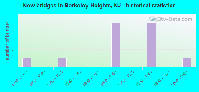
- New bridges - historical statistics
- 11910-1919
- 11930-1939
- 51960-1969
- 51980-1989
- 12000-2009


- Bridge Condition - Deck
- 50.0%Good
- 16.7%Satisfactory
- 33.3%Fair

- Bridge Condition - Superstructure
- 50.0%Good
- 16.7%Satisfactory
- 33.3%Fair

- Bridge Condition - Substructure
- 33.3%Good
- 50.0%Satisfactory
- 16.7%Fair

- Bridge Condition - Channel
- 28.6%Good
- 14.3%Satisfactory
- 42.9%Fair
- 14.3%Poor

- Bridge Condition - Culverts
- 33.3%Good
- 66.7%Fair
Find on map >> Show street view
Structure Number: 146015, Location: 1.95 MI N I-78&CR531 JCT (Lat: 40.679511, Lng: -74.452200), Route carried "on" structure: County highway 512, Year Built: 1936, Status: Open, Structure Length: 13.62m (44.69ft), Average Daily Traffic: 7,083 (year 2021), Truck Traffic: 4%, Average Future Daily Traffic: 8,643 (year 2041), Design Load: H 20, Features Intersected: GLADSTONE LN&PASSAIC RVR
Minimum Vertical Clearance: 30+ m (98+ ft), Kilometerpoint: 41.087, Lanes on structure: 2, Owner: County Highway Agency, Approaching Roadway Width: 11.6m (38.1ft), Skew: 6 degrees, Material/Design: Steel, Design/Construction: Girder and Floorbeam System, Number Of Spans In Main Unit: 1, Number Of Approach Spans: 11, Length of Maximum Span: 23.8m (78.1ft), Curb or Sidewalk Widths: Left: 1.4m (4.6ft), Right: 1.4m (4.6ft), Curb-To-Curb Width: 11.6m (38.1ft), Out-to-Out Width: 11.9m (39.0ft)
Condition: Deck: Fair, Superstructure: Fair, Substructure: Fair, Channel: Good, Operating Rating: 39.0 metric tons, Method Used To Determine Operating Rating: Load Factor (LF), Inventory Rating: 23.6 metric tons, Method Used To Determine Inventory Rating: Load Factor (LF), Structural Evaluation: Somewhat better than minimum adequacy, Deck Geometry: Somewhat better than minimum adequacy, Underclear: High priority of corrective action, Waterway Adequacy: Better than present minimum criteria, Approach Roadway Alignment: Somewhat better than minimum adequacy, Length Of Structure Improvement: 14.54m (47.70ft), Designated Inspection Frequency: Every 24 months, Critical Feature Inspection Frequency: Every 24 months, Inspection Date: Febuary 2021, Critical Feature Inspection Date: Febuary 2021, Bridge Improvement Cost: $4,119,000, Roadway Improvement Cost: $337,000, Total Project Cost: $5,447,000 ( Estimate for 2021), Deck Structure Type: Concrete Cast-file-Place, Wearing Surface/Protective System: Wearing Surface: Bituminous
Find on map >> Show street view
Structure Number: 181718, Location: 1.79 MI East of CR 531 (Lat: 40.662711, Lng: -74.424769), Route carried "on" structure: Interstate 78, Year Built: 1966, Status: Open, Structure Length: 15.30m (50.20ft), Average Daily Traffic: 47,740 (year 2020), Truck Traffic: 9%, Average Future Daily Traffic: 58,305 (year 2040), Design Load: HS 20, Features Intersected: PFLD AVE & GREEN BROOK
Minimum Vertical Clearance: 30+ m (98+ ft), Kilometerpoint: 68.832, Lanes on structure: 3, Lanes under structure: 4, Base Highway Network: Yes, Owner: State Highway Agency, Approaching Roadway Width: 15.5m (50.9ft), Skew: 1 degrees, Material/Design: Steel, Design/Construction: Stringer/Multi-beam, Number Of Spans In Main Unit: 4, Length of Maximum Span: 38.1m (125.0ft), Curb or Sidewalk Widths: Left: 0.2m (0.7ft), Right: 0.2m (0.7ft), Curb-To-Curb Width: 15.5m (50.9ft), Out-to-Out Width: 17.1m (56.1ft)
Condition: Deck: Good, Superstructure: Good, Substructure: Satisfactory, Channel: Good, Inventory Rating: 55.3 metric tons, Method Used To Determine Inventory Rating: Load Factor (LF), Structural Evaluation: Equal to present minimum criteria, Deck Geometry: Somewhat better than minimum adequacy, Underclear: Better than present minimum criteria, Waterway Adequacy: Superior to present desirable criteria, Approach Roadway Alignment: Better than present minimum criteria, Designated Inspection Frequency: Every 24 months, Inspection Date: September 2020, Deck Structure Type: Concrete Cast-file-Place, Wearing Surface/Protective System: Wearing Surface: Bituminous
Find on map >> Show street view
Structure Number: 2001001, Location: 0.2 MI NORTH OF CR 522 (Lat: 40.689561, Lng: -74.439539), Route carried "on" structure: City street , Year Built: 2002, Status: Open, Structure Length: 2.80m (9.19ft), Average Daily Traffic: 5,100 (year 2020), Truck Traffic: 1%, Average Future Daily Traffic: 6,222 (year 2040), Design Load: HS 25 or greater, Features Intersected: Passaic River, Facility Carried by Structure: Snyder Avenue
Minimum Vertical Clearance: 30+ m (98+ ft), Kilometerpoint: 0.000, Lanes on structure: 2, Owner: County Highway Agency, Approaching Roadway Width: 11.0m (36.1ft), Skew: 1 degrees, Material/Design: Prestressed concrete, Design/Construction: Box Beam or Girders - Multiple, Number Of Spans In Main Unit: 1, Length of Maximum Span: 26.5m (86.9ft), Curb or Sidewalk Widths: Left: 2.1m (6.9ft), Right: 2.1m (6.9ft), Curb-To-Curb Width: 11.0m (36.1ft), Out-to-Out Width: 15.8m (51.8ft)
Condition: Deck: Good, Superstructure: Good, Substructure: Good, Channel: Satisfactory, Inventory Rating: 62.6 metric tons, Method Used To Determine Inventory Rating: Load Factor (LF), Structural Evaluation: Better than present minimum criteria, Deck Geometry: Meets minimum limits, Waterway Adequacy: Somewhat better than minimum adequacy, Approach Roadway Alignment: Better than present minimum criteria, Designated Inspection Frequency: Every 24 months, Inspection Date: March 2020, Deck Structure Type: Concrete Cast-file-Place, Wearing Surface/Protective System: Wearing Surface: Other, Deck Protection: Galvanized Reinforcing
Find on map >> Show street view
Structure Number: 2001013, Location: 0.19 MILES NORTH OF I-78 (Lat: 40.663781, Lng: -74.428711), Route carried "on" structure: County highway 641, Year Built: 1916, Year Reconstructed: 1968, Status: Open, Structure Length: 0.91m (2.99ft), Average Daily Traffic: 9,532 (year 2020), Truck Traffic: 4%, Average Future Daily Traffic: 11,633 (year 2040), Features Intersected: GREEN BROOK, Facility Carried by Structure: PLAINFIELD AVENUE
Minimum Vertical Clearance: 30+ m (98+ ft), Kilometerpoint: 1.030, Lanes on structure: 4, Owner: County Highway Agency, Approaching Roadway Width: 14.0m (45.9ft), Skew: 4 degrees, Material/Design: Concrete, Design/Construction: Culvert, Number Of Spans In Main Unit: 1, Length of Maximum Span: 6.4m (21.0ft), Curb-To-Curb Width: 14.0m (45.9ft), Out-to-Out Width: 15.2m (49.9ft)
Condition: Channel: Fair, Culverts: Fair, Operating Rating: 43.5 metric tons, Method Used To Determine Operating Rating: Load Factor (LF), Inventory Rating: 25.4 metric tons, Method Used To Determine Inventory Rating: Load Factor (LF), Structural Evaluation: Somewhat better than minimum adequacy, Deck Geometry: High priority of replacement, Waterway Adequacy: Better than present minimum criteria, Approach Roadway Alignment: Better than present minimum criteria, Length Of Structure Improvement: 0.91m (2.99ft), Designated Inspection Frequency: Every 24 months, Inspection Date: March 2020, Bridge Improvement Cost: $27,000, Roadway Improvement Cost: $30,000, Total Project Cost: $93,000 ( Estimate for 2020), Wearing Surface/Protective System: Wearing Surface: Bituminous
Find on map >> Show street view
Structure Number: 2001014, Location: NEAR DIAMOND HILL ROAD (Lat: 40.667761, Lng: -74.405269), Route carried "on" structure: County highway 527, Year Built: 1968, Status: Open, Structure Length: 0.98m (3.22ft), Average Daily Traffic: 7,730 (year 2020), Truck Traffic: 4%, Average Future Daily Traffic: 9,275 (year 2040), Design Load: HS 20+Mod, Features Intersected: GREEN BROOK
Minimum Vertical Clearance: 30+ m (98+ ft), Kilometerpoint: 103.336, Lanes on structure: 4, Owner: County Highway Agency, Approaching Roadway Width: 14.0m (45.9ft), Skew: 1 degrees, Material/Design: Concrete continuous, Design/Construction: Culvert, Number Of Spans In Main Unit: 2, Length of Maximum Span: 4.6m (15.1ft), Curb or Sidewalk Widths: Left: 1.1m (3.6ft), Right: 1.5m (4.9ft), Curb-To-Curb Width: 14.0m (45.9ft), Out-to-Out Width: 18.0m (59.1ft)
Condition: Channel: Fair, Culverts: Good, Operating Rating: 54.4 metric tons, Method Used To Determine Operating Rating: Load Factor (LF), Inventory Rating: 32.7 metric tons, Method Used To Determine Inventory Rating: Load Factor (LF), Structural Evaluation: Better than present minimum criteria, Deck Geometry: High priority of replacement, Waterway Adequacy: Better than present minimum criteria, Approach Roadway Alignment: Better than present minimum criteria, Length Of Structure Improvement: 0.98m (3.22ft), Designated Inspection Frequency: Every 24 months, Inspection Date: April 2020, Bridge Improvement Cost: $38,000, Roadway Improvement Cost: $30,000, Total Project Cost: $119,000 ( Estimate for 2020)
Find on map >> Show street view
Structure Number: 2001016, Location: 1.58 MILES WEST OF CR 647 (Lat: 40.691600, Lng: -74.429450), Route carried "on" structure: County highway 512, Year Built: 1962, Status: Open, Structure Length: 0.73m (2.40ft), Average Daily Traffic: 10,420 (year 2020), Truck Traffic: 4%, Average Future Daily Traffic: 12,505 (year 2040), Design Load: HS 20, Features Intersected: STREAM 3-54, Facility Carried by Structure: SPRINGFIELD AVENUE
Minimum Vertical Clearance: 30+ m (98+ ft), Kilometerpoint: 43.436, Lanes on structure: 2, Owner: County Highway Agency, Approaching Roadway Width: 12.3m (40.4ft), Skew: 1 degrees, Material/Design: Prestressed concrete, Design/Construction: Slab, Number Of Spans In Main Unit: 1, Length of Maximum Span: 6.4m (21.0ft), Curb or Sidewalk Widths: Left: 2.6m (8.5ft), Right: 2.6m (8.5ft), Curb-To-Curb Width: 12.3m (40.4ft), Out-to-Out Width: 18.0m (59.1ft)
Condition: Deck: Fair, Superstructure: Fair, Substructure: Good, Channel: Fair, Operating Rating: 78.9 metric tons, Method Used To Determine Operating Rating: Load Factor (LF), Inventory Rating: 48.1 metric tons, Method Used To Determine Inventory Rating: Load Factor (LF), Structural Evaluation: Somewhat better than minimum adequacy, Deck Geometry: Somewhat better than minimum adequacy, Waterway Adequacy: Equal to present minimum criteria, Approach Roadway Alignment: Equal to present desirable criteria, Designated Inspection Frequency: Every 24 months, Inspection Date: April 2020, Deck Structure Type: Concrete Precast Panels, Wearing Surface/Protective System: Wearing Surface: Bituminous
Find on map >> Show street view
Structure Number: 2001073, Location: AT SOMERSET COUNTY LINE (Lat: 40.666139, Lng: -74.408981), Route carried "on" structure: City street , Year Built: 1968, Status: Open, Structure Length: 1.22m (4.00ft), Average Daily Traffic: 3,249 (year 2020), Truck Traffic: 1%, Average Future Daily Traffic: 3,963 (year 2040), Design Load: HS 20, Features Intersected: GREEN BROOK, Facility Carried by Structure: OAK WAY
Minimum Vertical Clearance: 30+ m (98+ ft), Kilometerpoint: 0.000, Lanes on structure: 2, Owner: City or Municipal Highway Agency, Approaching Roadway Width: 9.1m (29.9ft), Skew: 4 degrees, Material/Design: Concrete continuous, Design/Construction: Culvert, Number Of Spans In Main Unit: 2, Length of Maximum Span: 5.8m (19.0ft), Curb or Sidewalk Widths: Left: 0.3m (1.0ft), Right: 2.0m (6.6ft), Curb-To-Curb Width: 9.1m (29.9ft), Out-to-Out Width: 12.2m (40.0ft)
Condition: Channel: Poor, Culverts: Fair, Operating Rating: 35.4 metric tons, Method Used To Determine Operating Rating: Load Factor (LF), Inventory Rating: 20.9 metric tons, Method Used To Determine Inventory Rating: Load Factor (LF), Structural Evaluation: Somewhat better than minimum adequacy, Deck Geometry: Meets minimum limits, Waterway Adequacy: Equal to present desirable criteria, Approach Roadway Alignment: Equal to present desirable criteria, Designated Inspection Frequency: Every 24 months, Inspection Date: May 2020, Deck Structure Type: Concrete Cast-file-Place, Wearing Surface/Protective System: Wearing Surface: Bituminous
Find on map >> Show street view
Structure Number: 2010155, Location: 0.4 MI E OF I-78 EXIT 43 (Lat: 40.678181, Lng: -74.399189), Route carried "on" structure: County highway 640, Year Built: 1985, Status: Open, Structure Length: 8.84m (29.00ft), Average Daily Traffic: 2,670 (year 2020), Truck Traffic: 3%, Average Future Daily Traffic: 3,210 (year 2040), Design Load: HS 20+Mod, Features Intersected: I-78
Minimum Vertical Clearance: 30+ m (98+ ft), Kilometerpoint: 0.821, Lanes on structure: 2, Lanes under structure: 6, Owner: State Highway Agency, Approaching Roadway Width: 9.1m (29.9ft), Skew: 4 degrees, Material/Design: Steel continuous, Design/Construction: Stringer/Multi-beam, Number Of Spans In Main Unit: 3, Length of Maximum Span: 28.7m (94.2ft), Curb or Sidewalk Widths: Left: 1.8m (5.9ft), Right: 1.8m (5.9ft), Curb-To-Curb Width: 9.1m (29.9ft), Out-to-Out Width: 13.4m (44.0ft)
Condition: Deck: Good, Superstructure: Satisfactory, Substructure: Satisfactory, Inventory Rating: 56.2 metric tons, Method Used To Determine Inventory Rating: Load Factor (LF), Structural Evaluation: Equal to present minimum criteria, Deck Geometry: Meets minimum limits, Underclear: Equal to present minimum criteria, Approach Roadway Alignment: Equal to present minimum criteria, Designated Inspection Frequency: Every 24 months, Inspection Date: August 2020, Deck Structure Type: Concrete Cast-file-Place, Wearing Surface/Protective System: Deck Protection: Epoxy Coated Reinforcing
Find on map >> Show street view
Structure Number: 2010156, Location: 8.14 MI WEST OF GSP JCT (Lat: 40.684611, Lng: -74.387500), Route carried "on" structure: Interstate 78, Year Built: 1985, Status: Open, Structure Length: 2.07m (6.79ft), Average Daily Traffic: 98,171 (year 2019), Truck Traffic: 9%, Average Future Daily Traffic: 117,806 (year 2039), Design Load: HS 20+Mod, Features Intersected: GLENSIDE RD(CR 647)
Minimum Vertical Clearance: 30+ m (98+ ft), Kilometerpoint: 72.903, Lanes on structure: 6, Lanes under structure: 3, Base Highway Network: Yes, Owner: State Highway Agency, Approaching Roadway Width: 37.2m (122.0ft), Skew: 32 degrees, Material/Design: Steel, Design/Construction: Stringer/Multi-beam, Number Of Spans In Main Unit: 1, Length of Maximum Span: 19.5m (64.0ft), Curb-To-Curb Width: 36.4m (119.4ft), Out-to-Out Width: 38.3m (125.7ft)
Condition: Deck: Satisfactory, Superstructure: Good, Substructure: Satisfactory, Operating Rating: 79.8 metric tons, Method Used To Determine Operating Rating: Load Factor (LF), Inventory Rating: 47.2 metric tons, Method Used To Determine Inventory Rating: Load Factor (LF), Structural Evaluation: Equal to present minimum criteria, Deck Geometry: Superior to present desirable criteria, Underclear: Meets minimum limits, Approach Roadway Alignment: Equal to present desirable criteria, Designated Inspection Frequency: Every 24 months, Inspection Date: June 2021, Deck Structure Type: Concrete Cast-file-Place, Wearing Surface/Protective System: Wearing Surface: Bituminous, Deck Protection: Epoxy Coated Reinforcing
Find on map >> Show street view
Structure Number: 181718, Location: 1.79 MI East of CR 531 (Lat: 40.662711, Lng: -74.424769), Route carried "under" structure: County highway 663, Year Built: 1966, Structure Length: 0. m, Average Daily Traffic: 5,519 (year 2020), Truck Traffic: 4%, Features Intersected: PFLD AVE & GREEN BROOK, Facility Carried by Structure: I-78 WESTBOUND
Minimum Vertical Clearance: 11.45m (37.57ft), Kilometerpoint: 0.724, Lanes on structure: 3, Lanes under structure: 4, Material/Design: Steel, Design/Construction: Stringer/Multi-beam, Length of Maximum Span: 38.1m (125.0ft)
Find on map >> Show street view
Structure Number: 2010154, Location: 1.8 MI E OF I-78 EXIT 43 (Lat: 40.673119, Lng: -74.406639), Route carried "under" structure: County highway 655, Year Built: 1986, Structure Length: 0. m, Average Daily Traffic: 22,635 (year 2020), Truck Traffic: 4%, Features Intersected: DIAMOND HILL RD (CO 655), Facility Carried by Structure: I-78
Minimum Vertical Clearance: 5.21m (17.09ft), Kilometerpoint: 10.091, Lanes on structure: 6, Lanes under structure: 4, Material/Design: Steel, Design/Construction: Stringer/Multi-beam, Length of Maximum Span: 29.9m (98.1ft)
Find on map >> Show street view
Structure Number: 2010155, Location: 0.4 MI E OF I-78 EXIT 43 (Lat: 40.678181, Lng: -74.399189), Route carried "under" structure: Interstate 78, Year Built: 1985, Structure Length: 0. m, Average Daily Traffic: 111,000 (year 2020), Truck Traffic: 9%, Features Intersected: I-78, Facility Carried by Structure: CR640 (MCMANE AVE)
Minimum Vertical Clearance: 9.14m (29.99ft), Kilometerpoint: 71.648, Lanes on structure: 2, Lanes under structure: 6, Material/Design: Steel continuous, Design/Construction: Stringer/Multi-beam, Length of Maximum Span: 28.7m (94.2ft)
Find on map >> Show street view
Structure Number: 2010156, Location: 8.14 MI WEST OF GSP JCT (Lat: 40.684611, Lng: -74.387500), Route carried "under" structure: County highway 647, Year Built: 1985, Structure Length: 0. m, Average Daily Traffic: 2,611 (year 2019), Truck Traffic: 4%, Features Intersected: GLENSIDE RD(CR 647), Facility Carried by Structure: RT I-78
Minimum Vertical Clearance: 5.26m (17.26ft), Kilometerpoint: 0.032, Lanes on structure: 6, Lanes under structure: 3, Material/Design: Steel, Design/Construction: Stringer/Multi-beam, Length of Maximum Span: 19.5m (64.0ft)