Bridge Statistics for Beltsville, Maryland (MD)
Condition, Traffic, Stress, Structural Evaluation, Project Costs
- National Bridge Inventory (NBI) Statistics
- 45Number of bridges
- 715ft / 218mTotal length
- $26,012,000Total costs
- 2,322,618Total average daily traffic
- 116,010Total average daily truck traffic
- National Bridge Inventory (NBI) Registered Bridges for Beltsville
- No street view available for this location
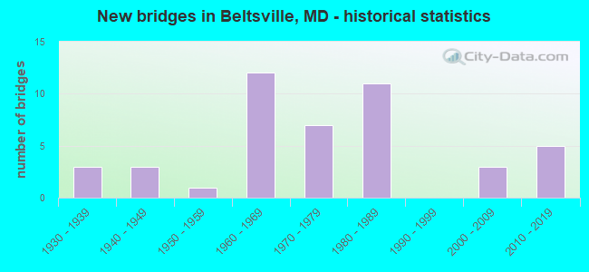
- New bridges - historical statistics
- 31930-1939
- 31940-1949
- 11950-1959
- 121960-1969
- 71970-1979
- 111980-1989
- 32000-2009
- 52010-2019

- Reconstructed bridges - Historical Statistics
- 11950-1959
- 11960-1969
- 01970-1979
- 41980-1989
- 11990-1999
- 22000-2009


- Bridge Condition - Deck
- 42.9%Good
- 38.1%Satisfactory
- 14.3%Fair
- 4.8%Poor

- Bridge Condition - Superstructure
- 14.3%Very good
- 19.0%Good
- 47.6%Satisfactory
- 14.3%Fair
- 4.8%Poor

- Bridge Condition - Substructure
- 14.3%Very good
- 28.6%Good
- 52.4%Satisfactory
- 4.8%Poor

- Bridge Condition - Channel
- 20.8%Very good
- 41.7%Good
- 29.2%Satisfactory
- 8.3%Fair

- Bridge Condition - Culverts
- 30.8%Good
- 53.8%Satisfactory
- 15.4%Fair
Find on map >> Show street view
Structure Number: 10000011001401, Location: 0.12 MILE WEST OF MD 560 (Lat: 39.395919, Lng: -79.375661), Route carried "on" structure: State highway 135, Year Built: 1959, Status: Open, Structure Length: 3.20m (10.50ft), Average Daily Traffic: 10,972 (year 2009), Truck Traffic: 8%, Average Future Daily Traffic: 13,412 (year 2026), Design Load: HS 20, Features Intersected: LITTLE YOUGHIOGHENY RIVE
Minimum Vertical Clearance: 30+ m (98+ ft), Kilometerpoint: 2.166, Lanes on structure: 2, Base Highway Network: Yes, Owner: State Highway Agency, Approaching Roadway Width: 13.4m (44.0ft), Skew: 3 degrees, Material/Design: Concrete, Design/Construction: Slab, Number Of Spans In Main Unit: 3, Length of Maximum Span: 12.2m (40.0ft), Curb or Sidewalk Widths: Left: 0.9m (3.0ft), Right: 0.9m (3.0ft), Curb-To-Curb Width: 9.1m (29.9ft), Out-to-Out Width: 11.6m (38.1ft)
Condition: Deck: Fair, Superstructure: Satisfactory, Substructure: Satisfactory, Channel: Very good, Operating Rating: 37.6 metric tons, Method Used To Determine Operating Rating: Load Factor (LF), Inventory Rating: 22.7 metric tons, Method Used To Determine Inventory Rating: Load Factor (LF), Structural Evaluation: Somewhat better than minimum adequacy, Deck Geometry: High priority of corrective action, Waterway Adequacy: Superior to present desirable criteria, Approach Roadway Alignment: Equal to present minimum criteria, Length Of Structure Improvement: 3.20m (10.50ft), Designated Inspection Frequency: Every 24 months, Inspection Date: August 2021, Bridge Improvement Cost: $241,000, Roadway Improvement Cost: $24,000, Total Project Cost: $265,000, Deck Structure Type: Concrete Cast-file-Place, Wearing Surface/Protective System: Wearing Surface: Bituminous
Find on map >> Show street view
Structure Number: 10000011003601, Location: 0.28 MILE EAST OF MD 560 (Lat: 39.397997, Lng: -79.369192), Route carried "on" structure: State highway 135, Year Built: 1932, Year Reconstructed: 1959, Status: Open, Structure Length: 1.04m (3.41ft), Average Daily Traffic: 6,712 (year 2009), Truck Traffic: 8%, Average Future Daily Traffic: 8,281 (year 2026), Design Load: HS 20, Features Intersected: LITTLE YOUGHIOGHENY RIVE
Minimum Vertical Clearance: 30+ m (98+ ft), Kilometerpoint: 2.816, Lanes on structure: 2, Base Highway Network: Yes, Owner: State Highway Agency, Approaching Roadway Width: 13.4m (44.0ft), Material/Design: Concrete, Design/Construction: Tee Beam, Number Of Spans In Main Unit: 1, Length of Maximum Span: 9.8m (32.2ft), Curb-To-Curb Width: 14.6m (47.9ft), Out-to-Out Width: 15.1m (49.5ft)
Condition: Deck: Satisfactory, Superstructure: Satisfactory, Substructure: Satisfactory, Channel: Good, Operating Rating: 58.0 metric tons, Method Used To Determine Operating Rating: Load Factor (LF), Inventory Rating: 34.9 metric tons, Method Used To Determine Inventory Rating: Load Factor (LF), Structural Evaluation: Equal to present minimum criteria, Deck Geometry: Superior to present desirable criteria, Waterway Adequacy: Superior to present desirable criteria, Approach Roadway Alignment: Equal to present desirable criteria, Designated Inspection Frequency: Every 24 months, Inspection Date: August 2021, Deck Structure Type: Concrete Cast-file-Place, Wearing Surface/Protective System: Wearing Surface: Bituminous
Find on map >> Show street view
Structure Number: 10000016003801, Location: 0.07 MILE NORTH OF MD 694 (Lat: 39.033475, Lng: -76.902406), Route carried "on" structure: State highway 212A, Year Built: 1937, Status: Open, Structure Length: 1.28m (4.20ft), Average Daily Traffic: 19,631 (year 2009), Truck Traffic: 8%, Average Future Daily Traffic: 40,840 (year 2026), Design Load: H 20, Features Intersected: INDIAN CREEK
Minimum Vertical Clearance: 30+ m (98+ ft), Kilometerpoint: 2.803, Lanes on structure: 2, Owner: State Highway Agency, Approaching Roadway Width: 9.1m (29.9ft), Skew: 1 degrees, Material/Design: Concrete, Design/Construction: Slab, Number Of Spans In Main Unit: 2, Length of Maximum Span: 6.4m (21.0ft), Curb-To-Curb Width: 9.1m (29.9ft), Out-to-Out Width: 10.5m (34.4ft)
Condition: Deck: Satisfactory, Superstructure: Satisfactory, Substructure: Satisfactory, Channel: Satisfactory, Operating Rating: 70.7 metric tons, Method Used To Determine Operating Rating: Load Factor (LF), Inventory Rating: 42.2 metric tons, Method Used To Determine Inventory Rating: Load Factor (LF), Structural Evaluation: Equal to present minimum criteria, Deck Geometry: High priority of corrective action, Waterway Adequacy: Superior to present desirable criteria, Approach Roadway Alignment: Equal to present minimum criteria, Length Of Structure Improvement: 1.28m (4.20ft), Designated Inspection Frequency: Every 24 months, Inspection Date: June 2021, Bridge Improvement Cost: $87,000, Roadway Improvement Cost: $9,000, Total Project Cost: $96,000, Deck Structure Type: Concrete Cast-file-Place, Wearing Surface/Protective System: Wearing Surface: Bituminous
Find on map >> Show street view
Structure Number: 10000016003901, Location: 0.08 MILE NORTH OF US 1 (Lat: 39.034617, Lng: -76.906203), Route carried "on" structure: State highway 212A, Year Built: 1937, Status: Open, Structure Length: 4.91m (16.11ft), Average Daily Traffic: 19,631 (year 2009), Truck Traffic: 8%, Average Future Daily Traffic: 40,840 (year 2026), Design Load: H 20, Features Intersected: CSX TRANS.
Minimum Vertical Clearance: 30+ m (98+ ft), Kilometerpoint: 2.465, Lanes on structure: 3, Owner: State Highway Agency, Approaching Roadway Width: 9.1m (29.9ft), Material/Design: Steel, Design/Construction: Stringer/Multi-beam, Number Of Spans In Main Unit: 4, Length of Maximum Span: 19.8m (65.0ft), Curb or Sidewalk Widths: Left: 1.6m (5.2ft), Right: 0.0m, Curb-To-Curb Width: 9.1m (29.9ft), Out-to-Out Width: 11.7m (38.4ft)
Condition: Deck: Fair, Superstructure: Fair, Substructure: Satisfactory, Operating Rating: 75.7 metric tons, Method Used To Determine Operating Rating: Load Factor (LF), Inventory Rating: 45.4 metric tons, Method Used To Determine Inventory Rating: Load Factor (LF), Structural Evaluation: Somewhat better than minimum adequacy, Deck Geometry: High priority of replacement, Underclear: Equal to present minimum criteria, Approach Roadway Alignment: Equal to present desirable criteria, Length Of Structure Improvement: 4.91m (16.11ft), Designated Inspection Frequency: Every 24 months, Inspection Date: March 2020, Bridge Improvement Cost: $744,000, Roadway Improvement Cost: $74,000, Total Project Cost: $818,000, Deck Structure Type: Concrete Cast-file-Place, Wearing Surface/Protective System: Wearing Surface: Monolithic Concrete
Find on map >> Show street view
Structure Number: 10000016004002, Location: .24 MILES SOUTH OF MD 212 (Lat: 39.047714, Lng: -76.931450), Route carried "on" structure: Interstate 95, Year Built: 1971, Status: Open, Structure Length: 1.52m (4.99ft), Average Daily Traffic: 187,850 (year 2009), Truck Traffic: 8%, Average Future Daily Traffic: 103,469 (year 2026), Design Load: HS 20, Features Intersected: LITTLE PAINT BRANCH
Minimum Vertical Clearance: 30+ m (98+ ft), Kilometerpoint: 45.578, Lanes on structure: 11, Base Highway Network: Yes, Owner: State Highway Agency, Approaching Roadway Width: 111.3m (365.2ft), Skew: 3 degrees, Material/Design: Concrete, Design/Construction: Culvert, Length of Maximum Span: 4.3m (14.1ft)
Condition: Channel: Fair, Culverts: Fair, Operating Rating: 43.1 metric tons, Method Used To Determine Operating Rating: Load Factor (LF), Inventory Rating: 25.4 metric tons, Method Used To Determine Inventory Rating: Load Factor (LF), Structural Evaluation: Somewhat better than minimum adequacy, Waterway Adequacy: Equal to present desirable criteria, Approach Roadway Alignment: Equal to present desirable criteria, Designated Inspection Frequency: Every 12 months, Inspection Date: June 2021
Find on map >> Show street view
Structure Number: 10000016004401, Location: 1.46 MI S OF MD 212 (Lat: 39.032769, Lng: -76.942994), Route carried "on" structure: County highway 14, Year Built: 1971, Year Reconstructed: 2008, Status: Open, Structure Length: 12.09m (39.67ft), Average Daily Traffic: 20,920 (year 2009), Truck Traffic: 5%, Average Future Daily Traffic: 14,157 (year 2026), Design Load: HS 25 or greater, Features Intersected: IS 95, Facility Carried by Structure: CHERRY HILL RD
Minimum Vertical Clearance: 30+ m (98+ ft), Kilometerpoint: 0.016, Lanes on structure: 4, Lanes under structure: 8, Owner: State Highway Agency, Approaching Roadway Width: 21.0m (68.9ft), Skew: 1 degrees, Material/Design: Steel continuous, Design/Construction: Stringer/Multi-beam, Number Of Spans In Main Unit: 4, Length of Maximum Span: 37.8m (124.0ft), Curb or Sidewalk Widths: Left: 1.7m (5.6ft), Right: 1.6m (5.2ft), Curb-To-Curb Width: 17.4m (57.1ft), Out-to-Out Width: 21.4m (70.2ft)
Condition: Deck: Good, Superstructure: Satisfactory, Substructure: Good, Operating Rating: 39.8 metric tons, Method Used To Determine Operating Rating: Load Factor (LF), Inventory Rating: 23.9 metric tons, Method Used To Determine Inventory Rating: Load Factor (LF), Structural Evaluation: Somewhat better than minimum adequacy, Deck Geometry: Somewhat better than minimum adequacy, Underclear: High priority of corrective action, Approach Roadway Alignment: Equal to present desirable criteria, Designated Inspection Frequency: Every 24 months, Inspection Date: January 2021, Deck Structure Type: Concrete Cast-file-Place, Wearing Surface/Protective System: Wearing Surface: Latex Concrete
Find on map >> Show street view
Structure Number: 10000016012901, Location: 0.21 M S OF BR NO 1612700 (Lat: 39.024872, Lng: -76.949303), Route carried "on" structure: Interstate 95X, Year Built: 1967, Status: Open, Structure Length: 4.60m (15.09ft), Average Daily Traffic: 1,880 (year 2006), Truck Traffic: 8%, Average Future Daily Traffic: 2,168 (year 2026), Design Load: HS 20, Features Intersected: IS 95 RAMP F(7)
Minimum Vertical Clearance: 30+ m (98+ ft), Kilometerpoint: 0.965, Lanes on structure: 4, Lanes under structure: 1, Base Highway Network: Yes, Owner: State Highway Agency, Approaching Roadway Width: 20.7m (67.9ft), Skew: 1 degrees, Material/Design: Steel continuous, Design/Construction: Stringer/Multi-beam, Number Of Spans In Main Unit: 3, Length of Maximum Span: 20.1m (65.9ft), Curb-To-Curb Width: 20.3m (66.6ft), Out-to-Out Width: 21.3m (69.9ft)
Condition: Deck: Satisfactory, Superstructure: Satisfactory, Substructure: Satisfactory, Operating Rating: 59.9 metric tons, Method Used To Determine Operating Rating: Load Factor (LF), Inventory Rating: 35.8 metric tons, Method Used To Determine Inventory Rating: Load Factor (LF), Structural Evaluation: Equal to present minimum criteria, Deck Geometry: Equal to present minimum criteria, Underclear: Somewhat better than minimum adequacy, Approach Roadway Alignment: Equal to present desirable criteria, Designated Inspection Frequency: Every 24 months, Inspection Date: April 2021, Deck Structure Type: Concrete Cast-file-Place, Wearing Surface/Protective System: Wearing Surface: Monolithic Concrete
Find on map >> Show street view
Structure Number: 10000016013001, Location: 0.28 M N OF PARK AND RIDE (Lat: 39.020653, Lng: -76.947169), Route carried "on" structure: Ramp Interstate 95X, Year Built: 1967, Status: Open, Structure Length: 6.46m (21.19ft), Average Daily Traffic: 346 (year 2006), Truck Traffic: 8%, Average Future Daily Traffic: 374 (year 2026), Design Load: HS 20, Features Intersected: IS 495 IL, TRIB PAINT BR
Minimum Vertical Clearance: 30+ m (98+ ft), Kilometerpoint: 0.451, Lanes on structure: 1, Lanes under structure: 5, Base Highway Network: Yes, Owner: State Highway Agency, Approaching Roadway Width: 9.1m (29.9ft), Skew: 1 degrees, Material/Design: Steel continuous, Design/Construction: Stringer/Multi-beam, Number Of Spans In Main Unit: 3, Length of Maximum Span: 26.8m (87.9ft), Curb-To-Curb Width: 8.7m (28.5ft), Out-to-Out Width: 9.8m (32.2ft)
Condition: Deck: Good, Superstructure: Satisfactory, Substructure: Good, Channel: Very good, Inventory Rating: 54.4 metric tons, Method Used To Determine Inventory Rating: Load Factor (LF), Structural Evaluation: Equal to present minimum criteria, Deck Geometry: Superior to present desirable criteria, Underclear: Somewhat better than minimum adequacy, Approach Roadway Alignment: Equal to present desirable criteria, Designated Inspection Frequency: Every 24 months, Inspection Date: August 2021, Deck Structure Type: Concrete Cast-file-Place, Wearing Surface/Protective System: Wearing Surface: Monolithic Concrete
Find on map >> Show street view
Structure Number: 100000160131025, Location: 1.42 M E OF MONTGOMERY CO (Lat: 39.021189, Lng: -76.945764), Route carried "on" structure: Interstate 495, Year Built: 1964, Status: Open, Structure Length: 3.63m (11.91ft), Average Daily Traffic: 139,680 (year 2009), Truck Traffic: 8%, Average Future Daily Traffic: 75,672 (year 2026), Design Load: HS 20, Features Intersected: PAINT BRANCH
Minimum Vertical Clearance: 30+ m (98+ ft), Kilometerpoint: 2.317, Lanes on structure: 4, Base Highway Network: Yes, Owner: State Highway Agency, Approaching Roadway Width: 20.7m (67.9ft), Material/Design: Concrete, Design/Construction: Culvert, Length of Maximum Span: 4.3m (14.1ft)
Condition: Channel: Satisfactory, Culverts: Satisfactory, Inventory Rating: 65.3 metric tons, Method Used To Determine Inventory Rating: Load Factor (LF), Structural Evaluation: Equal to present minimum criteria, Waterway Adequacy: Equal to present desirable criteria, Approach Roadway Alignment: Equal to present desirable criteria, Length Of Structure Improvement: 3.63m (11.91ft), Designated Inspection Frequency: Every 24 months, Inspection Date: March 2020, Bridge Improvement Cost: $571,000, Roadway Improvement Cost: $57,000, Total Project Cost: $628,000
Find on map >> Show street view
Structure Number: 100000160131026, Location: 1.42 M E OF MONTGOMERY CO (Lat: 39.022781, Lng: -76.945750), Route carried "on" structure: Interstate 495, Year Built: 1964, Status: Open, Structure Length: 2.83m (9.28ft), Average Daily Traffic: 139,680 (year 2009), Truck Traffic: 8%, Average Future Daily Traffic: 75,672 (year 2026), Design Load: HS 20, Features Intersected: PAINT BRANCH
Minimum Vertical Clearance: 30+ m (98+ ft), Kilometerpoint: 2.317, Lanes on structure: 4, Base Highway Network: Yes, Owner: State Highway Agency, Approaching Roadway Width: 20.7m (67.9ft), Material/Design: Concrete, Design/Construction: Culvert, Length of Maximum Span: 4.3m (14.1ft)
Condition: Channel: Satisfactory, Culverts: Good, Inventory Rating: 62.6 metric tons, Method Used To Determine Inventory Rating: Load Factor (LF), Structural Evaluation: Better than present minimum criteria, Waterway Adequacy: Better than present minimum criteria, Approach Roadway Alignment: Equal to present desirable criteria, Designated Inspection Frequency: Every 24 months, Inspection Date: March 2020
Find on map >> Show street view
Structure Number: 10000016013201, Location: 0.75 MI N OF US 1 (Lat: 39.022242, Lng: -76.939600), Route carried "on" structure: County highway 14, Year Built: 1963, Year Reconstructed: 1987, Status: Open, Structure Length: 5.03m (16.50ft), Average Daily Traffic: 20,920 (year 2009), Truck Traffic: 5%, Average Future Daily Traffic: 14,157 (year 2026), Design Load: H 20, Features Intersected: IS 95 NBR(OL), Facility Carried by Structure: CHERRY HILL RD
Minimum Vertical Clearance: 30+ m (98+ ft), Kilometerpoint: 1.480, Lanes on structure: 2, Lanes under structure: 5, Owner: State Highway Agency, Approaching Roadway Width: 8.5m (27.9ft), Skew: 2 degrees, Material/Design: Steel, Design/Construction: Stringer/Multi-beam, Number Of Spans In Main Unit: 3, Length of Maximum Span: 28.3m (92.8ft), Curb or Sidewalk Widths: Left: 0.0m, Right: 1.6m (5.2ft), Curb-To-Curb Width: 8.5m (27.9ft), Out-to-Out Width: 11.2m (36.7ft)
Condition: Deck: Good, Superstructure: Good, Substructure: Satisfactory, Operating Rating: 72.6 metric tons, Method Used To Determine Operating Rating: Load Factor (LF), Inventory Rating: 43.5 metric tons, Method Used To Determine Inventory Rating: Load Factor (LF), Structural Evaluation: Equal to present minimum criteria, Deck Geometry: High priority of replacement, Underclear: High priority of corrective action, Approach Roadway Alignment: Equal to present desirable criteria, Length Of Structure Improvement: 1.80m (5.91ft), Designated Inspection Frequency: Every 24 months, Inspection Date: August 2021, Bridge Improvement Cost: $130,000, Roadway Improvement Cost: $13,000, Total Project Cost: $143,000, Deck Structure Type: Concrete Cast-file-Place, Wearing Surface/Protective System: Wearing Surface: Low Slump Concrete
Find on map >> Show street view
Structure Number: 10000016013302, Location: 0.43 MILE NORTH OF US I (Lat: 39.020094, Lng: -76.933039), Route carried "on" structure: Interstate 95, Year Built: 1963, Year Reconstructed: 1991, Status: Open, Structure Length: 1.80m (5.91ft), Average Daily Traffic: 226,340 (year 2009), Truck Traffic: 8%, Average Future Daily Traffic: 250,754 (year 2026), Design Load: HS 20, Features Intersected: LITTLE PAINT BRANCH
Minimum Vertical Clearance: 30+ m (98+ ft), Kilometerpoint: 41.083, Lanes on structure: 10, Base Highway Network: Yes, Owner: State Highway Agency, Approaching Roadway Width: 51.8m (169.9ft), Material/Design: Concrete, Design/Construction: Culvert, Length of Maximum Span: 4.3m (14.1ft)
Condition: Channel: Fair, Culverts: Satisfactory, Inventory Rating: 61.7 metric tons, Method Used To Determine Inventory Rating: Load Factor (LF), Structural Evaluation: Equal to present minimum criteria, Waterway Adequacy: Better than present minimum criteria, Approach Roadway Alignment: Equal to present desirable criteria, Designated Inspection Frequency: Every 24 months, Inspection Date: May 2020
Find on map >> Show street view
Structure Number: 100000160136015, Location: 1.12 MILES N OF MD 201 (Lat: 39.015086, Lng: -76.908983), Route carried "on" structure: Interstate 95, Year Built: 1963, Status: Open, Structure Length: 5.22m (17.13ft), Average Daily Traffic: 110,617 (year 2006), Truck Traffic: 8%, Average Future Daily Traffic: 125,112 (year 2038), Design Load: HS 20, Features Intersected: CSX TRANS & WMATA
Minimum Vertical Clearance: 30+ m (98+ ft), Kilometerpoint: 38.793, Lanes on structure: 4, Base Highway Network: Yes, Owner: State Highway Agency, Approaching Roadway Width: 19.5m (64.0ft), Skew: 2 degrees, Material/Design: Steel, Design/Construction: Stringer/Multi-beam, Number Of Spans In Main Unit: 3, Length of Maximum Span: 21.3m (69.9ft), Curb-To-Curb Width: 20.7m (67.9ft), Out-to-Out Width: 21.3m (69.9ft)
Condition: Deck: Satisfactory, Superstructure: Satisfactory, Substructure: Satisfactory, Operating Rating: 55.3 metric tons, Method Used To Determine Operating Rating: Load Factor (LF), Inventory Rating: 33.1 metric tons, Method Used To Determine Inventory Rating: Load Factor (LF), Structural Evaluation: Equal to present minimum criteria, Deck Geometry: Equal to present minimum criteria, Underclear: Equal to present desirable criteria, Approach Roadway Alignment: Equal to present desirable criteria, Length Of Structure Improvement: 4.94m (16.21ft), Designated Inspection Frequency: Every 24 months, Inspection Date: Febuary 2020, Bridge Improvement Cost: $680,000, Roadway Improvement Cost: $68,000, Total Project Cost: $748,000, Deck Structure Type: Concrete Cast-file-Place, Wearing Surface/Protective System: Wearing Surface: Bituminous
Find on map >> Show street view
Structure Number: 100000160136016, Location: 1.12 MILES N OF MD 201 (Lat: 39.015297, Lng: -76.908322), Route carried "on" structure: Interstate 95, Year Built: 1963, Status: Open, Structure Length: 4.94m (16.21ft), Average Daily Traffic: 110,617 (year 2006), Truck Traffic: 8%, Average Future Daily Traffic: 125,112 (year 2038), Design Load: HS 20, Features Intersected: CSX TRANS & WMATA
Minimum Vertical Clearance: 30+ m (98+ ft), Kilometerpoint: 38.793, Lanes on structure: 4, Base Highway Network: Yes, Owner: State Highway Agency, Approaching Roadway Width: 19.5m (64.0ft), Skew: 2 degrees, Material/Design: Steel, Design/Construction: Stringer/Multi-beam, Number Of Spans In Main Unit: 3, Length of Maximum Span: 21.3m (69.9ft), Curb-To-Curb Width: 20.7m (67.9ft), Out-to-Out Width: 21.3m (69.9ft)
Condition: Deck: Satisfactory, Superstructure: Satisfactory, Substructure: Satisfactory, Operating Rating: 55.3 metric tons, Method Used To Determine Operating Rating: Load Factor (LF), Inventory Rating: 33.1 metric tons, Method Used To Determine Inventory Rating: Load Factor (LF), Structural Evaluation: Equal to present minimum criteria, Deck Geometry: Equal to present minimum criteria, Underclear: Equal to present desirable criteria, Approach Roadway Alignment: Equal to present desirable criteria, Designated Inspection Frequency: Every 24 months, Inspection Date: Febuary 2020, Deck Structure Type: Concrete Cast-file-Place, Wearing Surface/Protective System: Wearing Surface: Bituminous
Find on map >> Show street view
Structure Number: 10000016017501, Location: 0.75 MI N OF US 1 (Lat: 39.021378, Lng: -76.939544), Route carried "on" structure: County highway 14, Year Built: 1987, Status: Open, Structure Length: 5.52m (18.11ft), Average Daily Traffic: 20,920 (year 2009), Truck Traffic: 5%, Average Future Daily Traffic: 14,157 (year 2026), Design Load: HS 20, Features Intersected: IS 495 IL & IS 95 RMP 4, Facility Carried by Structure: CHERRY HILL ROAD
Minimum Vertical Clearance: 30+ m (98+ ft), Kilometerpoint: 1.356, Lanes on structure: 2, Lanes under structure: 7, Owner: State Highway Agency, Approaching Roadway Width: 11.0m (36.1ft), Skew: 1 degrees, Material/Design: Steel continuous, Design/Construction: Stringer/Multi-beam, Number Of Spans In Main Unit: 2, Length of Maximum Span: 32.9m (107.9ft), Curb or Sidewalk Widths: Left: 1.6m (5.2ft), Right: 0.0m, Curb-To-Curb Width: 8.5m (27.9ft), Out-to-Out Width: 10.9m (35.8ft)
Condition: Deck: Good, Superstructure: Good, Substructure: Good, Inventory Rating: 78.5 metric tons, Method Used To Determine Inventory Rating: Load Factor (LF), Structural Evaluation: Better than present minimum criteria, Deck Geometry: High priority of replacement, Underclear: Equal to present minimum criteria, Approach Roadway Alignment: Equal to present desirable criteria, Length Of Structure Improvement: 5.52m (18.11ft), Designated Inspection Frequency: Every 24 months, Inspection Date: September 2021, Bridge Improvement Cost: $388,000, Roadway Improvement Cost: $39,000, Total Project Cost: $427,000, Deck Structure Type: Concrete Cast-file-Place, Wearing Surface/Protective System: Wearing Surface: Monolithic Concrete
Find on map >> Show street view
Structure Number: 10000016017601, Location: 0.92 MILE NORTH OF US 1 (Lat: 39.026956, Lng: -76.950103), Route carried "on" structure: Ramp Interstate 95, Year Built: 1987, Status: Open, Structure Length: 79.86m (262.01ft), Average Daily Traffic: 63,374 (year 2019), Truck Traffic: 9%, Average Future Daily Traffic: 94,170 (year 2039), Design Load: HS 20, Features Intersected: IS95X NB,IS495OL,RAMP F
Minimum Vertical Clearance: 30+ m (98+ ft), Kilometerpoint: 42.011, Lanes on structure: 2, Lanes under structure: 7, Base Highway Network: Yes, Owner: State Highway Agency, Approaching Roadway Width: 13.4m (44.0ft), Skew: 9 degrees, Material/Design: Steel continuous, Design/Construction: Stringer/Multi-beam, Number Of Spans In Main Unit: 18, Length of Maximum Span: 61.0m (200.1ft), Curb-To-Curb Width: 12.3m (40.4ft), Out-to-Out Width: 13.3m (43.6ft)
Condition: Deck: Good, Superstructure: Satisfactory, Substructure: Satisfactory, Channel: Very good, Operating Rating: 59.0 metric tons, Method Used To Determine Operating Rating: Load Factor (LF), Inventory Rating: 35.8 metric tons, Method Used To Determine Inventory Rating: Load Factor (LF), Structural Evaluation: Equal to present minimum criteria, Deck Geometry: Superior to present desirable criteria, Underclear: Equal to present minimum criteria, Waterway Adequacy: Superior to present desirable criteria, Approach Roadway Alignment: Equal to present desirable criteria, Length Of Structure Improvement: 79.86m (262.01ft), Designated Inspection Frequency: Every 24 months, Inspection Date: July 2021, Deck Structure Type: Concrete Cast-file-Place, Wearing Surface/Protective System: Wearing Surface: Monolithic Concrete, Deck Protection: Epoxy Coated Reinforcing
Find on map >> Show street view
Structure Number: 10000016025202, Location: 0.25 MILE NORTH OF MD 212 (Lat: 0.000108, Lng: -0.000019), Route carried "on" structure: US 1, Year Built: 1975, Status: Open, Structure Length: 0.67m (2.20ft), Average Daily Traffic: 33,642 (year 2009), Average Future Daily Traffic: 40,473 (year 2026), Features Intersected: INDIAN CREEK
Minimum Vertical Clearance: 30+ m (98+ ft), Kilometerpoint: 13.318, Lanes on structure: 4, Base Highway Network: Yes, Owner: State Highway Agency, Approaching Roadway Width: 18.3m (60.0ft), Material/Design: Concrete, Design/Construction: Culvert, Length of Maximum Span: 2.7m (8.9ft), Curb-To-Curb Width: 17.7m (58.1ft), Out-to-Out Width: 18.3m (60.0ft)
Condition: Channel: Very good, Culverts: Satisfactory, Operating Rating: 32.7 metric tons, Method Used To Determine Operating Rating: Field evaluation and documented engineering judgment, Inventory Rating: 32.7 metric tons, Method Used To Determine Inventory Rating: Field evaluation and documented engineering judgment, Structural Evaluation: Equal to present minimum criteria, Deck Geometry: Somewhat better than minimum adequacy, Waterway Adequacy: Equal to present desirable criteria, Approach Roadway Alignment: Equal to present desirable criteria, Designated Inspection Frequency: Every 24 months, Inspection Date: October 2021, Deck Structure Type: Concrete Cast-file-Place, Wearing Surface/Protective System: Wearing Surface: Bituminous
Find on map >> Show street view
Structure Number: 10000016026301, Location: 154' S of Ammendale Road (Lat: 39.050389, Lng: -76.897514), Route carried "on" structure: US 1, Year Built: 2016, Status: Open, Structure Length: 1.19m (3.90ft), Average Daily Traffic: 32,400 (year 2011), Truck Traffic: 7%, Average Future Daily Traffic: 48,525 (year 2031), Features Intersected: AMMENDALE BRANCH
Minimum Vertical Clearance: 30+ m (98+ ft), Kilometerpoint: 14.867, Lanes on structure: 6, Owner: State Highway Agency, Approaching Roadway Width: 22.9m (75.1ft), Skew: 1 degrees, Material/Design: Prestressed concrete, Design/Construction: Slab, Number Of Spans In Main Unit: 1, Length of Maximum Span: 10.7m (35.1ft), Curb or Sidewalk Widths: Left: 3.4m (11.2ft), Right: 0.0m, Curb-To-Curb Width: 24.1m (79.1ft), Out-to-Out Width: 29.0m (95.1ft)
Condition: Deck: Satisfactory, Superstructure: Very good, Substructure: Very good, Channel: Very good, Operating Rating: 57.0 metric tons, Method Used To Determine Operating Rating: Load and Resistance Factor Rating (LRFR) rating reported by rating factor(RF) method using HL-93 loadings, Inventory Rating: 44.1 metric tons, Method Used To Determine Inventory Rating: Load and Resistance Factor Rating (LRFR) rating reported by rating factor(RF) method using HL-93 loadings, Structural Evaluation: Equal to present desirable criteria, Deck Geometry: Somewhat better than minimum adequacy, Waterway Adequacy: Equal to present desirable criteria, Approach Roadway Alignment: Equal to present desirable criteria, Designated Inspection Frequency: Every 24 months, Inspection Date: January 2021, Deck Structure Type: Concrete Cast-file-Place, Wearing Surface/Protective System: Wearing Surface: Monolithic Concrete, Deck Protection: Epoxy Coated Reinforcing
Find on map >> Show street view
Structure Number: 200000P-010201, Location: MUIRKIRK ROAD AT US 1 (Lat: 4.512172, Lng: -76.885658), Route carried "on" structure: County highway 21, Year Built: 1970, Year Reconstructed: 2008, Status: Posted for load, Structure Length: 7.32m (24.02ft), Average Daily Traffic: 17,575 (year 2018), Truck Traffic: 10%, Average Future Daily Traffic: 26,120 (year 2038), Design Load: HS 20, Features Intersected: US 1 & CSXT, Facility Carried by Structure: MUIRKIRK ROAD
Minimum Vertical Clearance: 30+ m (98+ ft), Kilometerpoint: 4.634, Lanes on structure: 4, Lanes under structure: 4, Owner: County Highway Agency, Approaching Roadway Width: 15.9m (52.2ft), Skew: 1 degrees, Material/Design: Steel continuous, Design/Construction: Stringer/Multi-beam, Number Of Spans In Main Unit: 4, Length of Maximum Span: 24.1m (79.1ft), Curb or Sidewalk Widths: Left: 1.5m (4.9ft), Right: 1.5m (4.9ft), Curb-To-Curb Width: 15.9m (52.2ft), Out-to-Out Width: 19.5m (64.0ft)
Condition: Deck: Satisfactory, Superstructure: Fair, Substructure: Satisfactory, Operating Rating: 57.6 metric tons, Method Used To Determine Operating Rating: Load Factor (LF), Inventory Rating: 34.5 metric tons, Method Used To Determine Inventory Rating: Load Factor (LF), Structural Evaluation: Somewhat better than minimum adequacy, Deck Geometry: Meets minimum limits, Underclear: Meets minimum limits, Approach Roadway Alignment: Equal to present minimum criteria, Length Of Structure Improvement: 8.38m (27.49ft), Designated Inspection Frequency: Every 24 months, Inspection Date: April 2020, Bridge Improvement Cost: $2,870,000, Roadway Improvement Cost: $29,000, Total Project Cost: $2,899,000, Deck Structure Type: Concrete Cast-file-Place, Wearing Surface/Protective System: Deck Protection: Epoxy Coated Reinforcing
Find on map >> Show street view
Structure Number: 200000P-013402, Location: 1.0 MILE WEST OF US 1 (Lat: 39.056017, Lng: -76.907483), Route carried "on" structure: County highway 10, Year Built: 2001, Status: Open, Structure Length: 0.94m (3.08ft), Average Daily Traffic: 23,965 (year 2017), Truck Traffic: 10%, Average Future Daily Traffic: 39,270 (year 2037), Features Intersected: INDIAN CREEK, Facility Carried by Structure: AMMENDALE ROAD
Minimum Vertical Clearance: 30+ m (98+ ft), Kilometerpoint: 0.000, Lanes on structure: 5, Owner: County Highway Agency, Approaching Roadway Width: 28.0m (91.9ft), Skew: 1 degrees, Material/Design: Concrete, Design/Construction: Culvert, Length of Maximum Span: 3.0m (9.8ft)
Condition: Channel: Good, Culverts: Good, Operating Rating: 86.6 metric tons, Method Used To Determine Operating Rating: Load Factor (LF), Inventory Rating: 51.7 metric tons, Method Used To Determine Inventory Rating: Load Factor (LF), Structural Evaluation: Better than present minimum criteria, Waterway Adequacy: Equal to present desirable criteria, Approach Roadway Alignment: Equal to present desirable criteria, Designated Inspection Frequency: Every 24 months, Inspection Date: September 2021, Wearing Surface/Protective System: Wearing Surface: Bituminous
Find on map >> Show street view
Structure Number: 200000P-017202, Location: 0.04 MI W OF US 1 (Lat: 39.062108, Lng: -76.886039), Route carried "on" structure: County highway 21, Year Built: 1969, Status: Open, Structure Length: 0.82m (2.69ft), Average Daily Traffic: 23,091 (year 2018), Truck Traffic: 5%, Average Future Daily Traffic: 34,150 (year 2038), Design Load: HS 20, Features Intersected: MUIRKIRK BR OF INDIAN CR, Facility Carried by Structure: MUIRKIRK ROAD
Minimum Vertical Clearance: 30+ m (98+ ft), Kilometerpoint: 0.000, Lanes on structure: 4, Owner: County Highway Agency, Approaching Roadway Width: 15.9m (52.2ft), Material/Design: Concrete, Design/Construction: Culvert, Length of Maximum Span: 4.0m (13.1ft), Curb or Sidewalk Widths: Left: 1.5m (4.9ft), Right: 1.5m (4.9ft)
Condition: Channel: Satisfactory, Culverts: Satisfactory, Inventory Rating: 62.1 metric tons, Method Used To Determine Inventory Rating: Load Factor (LF), Structural Evaluation: Equal to present minimum criteria, Waterway Adequacy: Equal to present minimum criteria, Approach Roadway Alignment: Equal to present minimum criteria, Designated Inspection Frequency: Every 24 months, Inspection Date: January 2021
Find on map >> Show street view
Structure Number: 200000P-017502, Location: 0.03 MI NE OF SYCAMORE RD (Lat: 39.044611, Lng: -76.900225), Route carried "on" structure: County highway 26, Year Built: 1984, Status: Posted for load, Structure Length: 0.79m (2.59ft), Average Daily Traffic: 2,015 (year 2015), Truck Traffic: 20%, Average Future Daily Traffic: 3,000 (year 2035), Features Intersected: INDIAN CREEK, Facility Carried by Structure: EAST MAPLE AVENUE
Minimum Vertical Clearance: 30+ m (98+ ft), Kilometerpoint: 0.322, Lanes on structure: 2, Owner: County Highway Agency, Approaching Roadway Width: 10.4m (34.1ft), Skew: 1 degrees, Material/Design: Concrete, Design/Construction: Culvert, Length of Maximum Span: 3.7m (12.1ft)
Condition: Channel: Good, Culverts: Satisfactory, Operating Rating: 60.3 metric tons, Method Used To Determine Operating Rating: Load Factor (LF), Inventory Rating: 36.3 metric tons, Method Used To Determine Inventory Rating: Load Factor (LF), Structural Evaluation: Equal to present minimum criteria, Waterway Adequacy: Better than present minimum criteria, Approach Roadway Alignment: Equal to present desirable criteria, Designated Inspection Frequency: Every 24 months, Inspection Date: January 2021
Find on map >> Show street view
Structure Number: 200000P-018002, Location: 0.03 MI W OF US 1 (Lat: 39.051156, Lng: -76.897561), Route carried "on" structure: County highway 10, Year Built: 1985, Status: Open, Structure Length: 0.67m (2.20ft), Average Daily Traffic: 1,822 (year 2021), Truck Traffic: 10%, Average Future Daily Traffic: 2,482 (year 2041), Features Intersected: TRIBUTARY TO INDIAN CREE, Facility Carried by Structure: AMMENDALE ROAD
Minimum Vertical Clearance: 30+ m (98+ ft), Kilometerpoint: 2.655, Lanes on structure: 4, Owner: County Highway Agency, Approaching Roadway Width: 15.9m (52.2ft), Material/Design: Concrete, Design/Construction: Culvert, Number Of Spans In Main Unit: 3, Length of Maximum Span: 1.8m (5.9ft), Curb or Sidewalk Widths: Left: 1.2m (3.9ft), Right: 1.2m (3.9ft)
Condition: Channel: Satisfactory, Culverts: Satisfactory, Operating Rating: 32.7 metric tons, Method Used To Determine Operating Rating: Field evaluation and documented engineering judgment, Inventory Rating: 32.7 metric tons, Method Used To Determine Inventory Rating: Field evaluation and documented engineering judgment, Structural Evaluation: Equal to present minimum criteria, Waterway Adequacy: Somewhat better than minimum adequacy, Approach Roadway Alignment: Equal to present desirable criteria, Designated Inspection Frequency: Every 24 months, Inspection Date: January 2021
Find on map >> Show street view
Structure Number: 200000P-018801, Location: 0.15 MI W OF MD 295 (Lat: 39.021856, Lng: -76.859339), Route carried "on" structure: County highway 27, Year Built: 2003, Status: Open, Structure Length: 0.91m (2.99ft), Average Daily Traffic: 450 (year 2015), Truck Traffic: 8%, Average Future Daily Traffic: 669 (year 2035), Design Load: HS 25 or greater, Features Intersected: BEAVER DAM CREEK, Facility Carried by Structure: BEAVER DAM ROAD
Minimum Vertical Clearance: 30+ m (98+ ft), Kilometerpoint: 3.974, Lanes on structure: 2, Owner: County Highway Agency, Approaching Roadway Width: 12.2m (40.0ft), Material/Design: Concrete, Design/Construction: Arch - Deck, Number Of Spans In Main Unit: 1, Length of Maximum Span: 9.1m (29.9ft), Curb-To-Curb Width: 11.2m (36.7ft), Out-to-Out Width: 12.2m (40.0ft)
Condition: Deck: Good, Superstructure: Good, Substructure: Very good, Channel: Good, Inventory Rating: 59.0 metric tons, Method Used To Determine Inventory Rating: Load Factor (LF), Structural Evaluation: Better than present minimum criteria, Deck Geometry: Better than present minimum criteria, Waterway Adequacy: Equal to present minimum criteria, Approach Roadway Alignment: Equal to present desirable criteria, Designated Inspection Frequency: Every 24 months, Inspection Date: September 2021, Deck Structure Type: Concrete Cast-file-Place, Wearing Surface/Protective System: Wearing Surface: Bituminous
Find on map >> Show street view
Structure Number: 200000P-018901, Location: 0.09 MI W OF MD 201 (Lat: 0.000108, Lng: -0.000214), Route carried "on" structure: County highway 20, Year Built: 1946, Year Reconstructed: 1974, Status: Closed, Structure Length: 1.13m (3.71ft), Average Daily Traffic: 13,500 (year 2017), Truck Traffic: 10%, Average Future Daily Traffic: 20,070 (year 2037), Features Intersected: INDIAN CREEK, Facility Carried by Structure: SUNNYSIDE AVENUE
Minimum Vertical Clearance: 30+ m (98+ ft), Kilometerpoint: 0.145, Lanes on structure: 2, Owner: County Highway Agency, Approaching Roadway Width: 6.7m (22.0ft), Material/Design: Steel, Design/Construction: Stringer/Multi-beam, Number Of Spans In Main Unit: 1, Length of Maximum Span: 10.4m (34.1ft), Curb-To-Curb Width: 6.7m (22.0ft), Out-to-Out Width: 6.9m (22.6ft)
Condition: Deck: Poor, Superstructure: Poor, Substructure: Poor, Channel: Satisfactory, Operating Rating: 32.7 metric tons, Method Used To Determine Operating Rating: Load Factor (LF), Inventory Rating: 19.5 metric tons, Method Used To Determine Inventory Rating: Load Factor (LF), Structural Evaluation: Meets minimum limits, Waterway Adequacy: Somewhat better than minimum adequacy, Approach Roadway Alignment: Equal to present minimum criteria, Bridge Posting: Required (Relationship of Operating Rating to Maximum Legal Load: 20.0 - 29.9% below), Length Of Structure Improvement: 2.19m (7.19ft), Designated Inspection Frequency: Every 12 months, Inspection Date: April 2020, Bridge Improvement Cost: $675,000, Roadway Improvement Cost: $800,000, Total Project Cost: $1,745,000, Deck Structure Type: Concrete Cast-file-Place, Wearing Surface/Protective System: Wearing Surface: Monolithic Concrete
Find on map >> Show street view
Structure Number: 200000P-019001, Location: .5 MI W OF US RTE 1 (Lat: 39.034164, Lng: -76.930156), Route carried "on" structure: County highway 15, Year Built: 1985, Status: Open, Structure Length: 2.65m (8.69ft), Average Daily Traffic: 5,820 (year 2017), Truck Traffic: 10%, Average Future Daily Traffic: 8,660 (year 2037), Design Load: HS 20, Features Intersected: LITTLE PAINT BRANCH, Facility Carried by Structure: SELLMAN ROAD
Minimum Vertical Clearance: 30+ m (98+ ft), Kilometerpoint: 1.947, Lanes on structure: 2, Owner: County Highway Agency, Approaching Roadway Width: 13.4m (44.0ft), Material/Design: Steel continuous, Design/Construction: Stringer/Multi-beam, Number Of Spans In Main Unit: 2, Length of Maximum Span: 12.8m (42.0ft), Curb-To-Curb Width: 13.4m (44.0ft), Out-to-Out Width: 14.4m (47.2ft)
Condition: Deck: Good, Superstructure: Satisfactory, Substructure: Good, Channel: Good, Operating Rating: 55.8 metric tons, Method Used To Determine Operating Rating: Load Factor (LF), Inventory Rating: 33.6 metric tons, Method Used To Determine Inventory Rating: Load Factor (LF), Structural Evaluation: Equal to present minimum criteria, Deck Geometry: Equal to present minimum criteria, Waterway Adequacy: Equal to present desirable criteria, Approach Roadway Alignment: Equal to present desirable criteria, Designated Inspection Frequency: Every 24 months, Inspection Date: Febuary 2021, Deck Structure Type: Concrete Cast-file-Place, Wearing Surface/Protective System: Wearing Surface: Integral Concrete
Find on map >> Show street view
Structure Number: 200000P-019102, Location: 1000 FT NE OF US 1 (Lat: 39.038231, Lng: -76.902350), Route carried "on" structure: County highway 23, Year Built: 1984, Status: Posted for load, Structure Length: 1.71m (5.61ft), Average Daily Traffic: 14,447 (year 2017), Truck Traffic: 5%, Average Future Daily Traffic: 21,470 (year 2037), Design Load: HS 20, Features Intersected: INDIAN CREEK, Facility Carried by Structure: OLD BALTIMORE PIKE
Minimum Vertical Clearance: 30+ m (98+ ft), Kilometerpoint: 0.000, Lanes on structure: 2, Owner: County Highway Agency, Approaching Roadway Width: 7.3m (24.0ft), Skew: 3 degrees, Material/Design: Concrete, Design/Construction: Culvert, Length of Maximum Span: 5.5m (18.0ft), Curb-To-Curb Width: 15.2m (49.9ft), Out-to-Out Width: 16.2m (53.1ft)
Condition: Channel: Good, Culverts: Satisfactory, Operating Rating: 44.0 metric tons, Method Used To Determine Operating Rating: Load Factor (LF), Inventory Rating: 26.3 metric tons, Method Used To Determine Inventory Rating: Load Factor (LF), Structural Evaluation: Equal to present minimum criteria, Deck Geometry: Superior to present desirable criteria, Waterway Adequacy: Better than present minimum criteria, Approach Roadway Alignment: Equal to present desirable criteria, Bridge Posting: Required (Relationship of Operating Rating to Maximum Legal Load: 10.0 - 19.9% below), Length Of Structure Improvement: 1.98m (6.50ft), Designated Inspection Frequency: Every 12 months, Inspection Date: January 2021
Find on map >> Show street view
Structure Number: 200000P-019201, Location: 0.12 MI W OF MD 201 (Lat: 39.042778, Lng: -76.900000), Route carried "on" structure: County highway 22, Year Built: 2000, Status: Open, Structure Length: 2.04m (6.69ft), Average Daily Traffic: 1,880 (year 2017), Truck Traffic: 4%, Average Future Daily Traffic: 2,800 (year 2037), Design Load: HS 25 or greater, Features Intersected: INDIAN CREEK, Facility Carried by Structure: ODELL ROAD
Minimum Vertical Clearance: 30+ m (98+ ft), Kilometerpoint: 0.322, Lanes on structure: 2, Owner: County Highway Agency, Approaching Roadway Width: 10.4m (34.1ft), Skew: 3 degrees, Material/Design: Prestressed concrete, Design/Construction: Box Beam or Girders - Multiple, Number Of Spans In Main Unit: 1, Length of Maximum Span: 19.2m (63.0ft), Curb-To-Curb Width: 10.4m (34.1ft), Out-to-Out Width: 11.3m (37.1ft)
Condition: Deck: Satisfactory, Superstructure: Very good, Substructure: Good, Channel: Good, Operating Rating: 85.7 metric tons, Method Used To Determine Operating Rating: Load Factor (LF), Inventory Rating: 51.7 metric tons, Method Used To Determine Inventory Rating: Load Factor (LF), Structural Evaluation: Better than present minimum criteria, Deck Geometry: Equal to present minimum criteria, Waterway Adequacy: Better than present minimum criteria, Approach Roadway Alignment: Equal to present minimum criteria, Designated Inspection Frequency: Every 24 months, Inspection Date: March 2021, Deck Structure Type: Concrete Cast-file-Place, Wearing Surface/Protective System: Wearing Surface: Monolithic Concrete, Deck Protection: Epoxy Coated Reinforcing
Find on map >> Show street view
Structure Number: 200000P-019302, Location: 0.26 MI W OF US 1 (Lat: 39.052256, Lng: -76.898544), Route carried "on" structure: County highway 10, Year Built: 1948, Year Reconstructed: 1986, Status: Open, Structure Length: 0.79m (2.59ft), Average Daily Traffic: 1,743 (year 2015), Truck Traffic: 10%, Average Future Daily Traffic: 2,035 (year 2035), Design Load: H 20, Features Intersected: TRIB TO INDIAN CREEK, Facility Carried by Structure: AMMENDALE ROAD
Minimum Vertical Clearance: 30+ m (98+ ft), Kilometerpoint: 2.494, Lanes on structure: 4, Owner: County Highway Agency, Approaching Roadway Width: 15.9m (52.2ft), Skew: 4 degrees, Material/Design: Concrete, Design/Construction: Culvert, Length of Maximum Span: 3.7m (12.1ft), Curb or Sidewalk Widths: Left: 1.2m (3.9ft), Right: 1.2m (3.9ft)
Condition: Channel: Satisfactory, Culverts: Fair, Operating Rating: 35.8 metric tons, Method Used To Determine Operating Rating: Field evaluation and documented engineering judgment, Inventory Rating: 21.3 metric tons, Method Used To Determine Inventory Rating: Field evaluation and documented engineering judgment, Structural Evaluation: Somewhat better than minimum adequacy, Waterway Adequacy: Somewhat better than minimum adequacy, Approach Roadway Alignment: Equal to present desirable criteria, Length Of Structure Improvement: 0.79m (2.59ft), Designated Inspection Frequency: Every 12 months, Inspection Date: January 2021, Bridge Improvement Cost: $4,000, Roadway Improvement Cost: $1,000, Total Project Cost: $5,000
Find on map >> Show street view
Structure Number: 2001003P, Location: CAPITAL BELTWAY TO EXIT 2 (Lat: 39.028861, Lng: -76.929750), Route carried "on" structure: Federal lands road 45, Year Built: 1947, Year Reconstructed: 1990, Status: Open, Structure Length: 1.83m (6.00ft), Average Daily Traffic: 700 (year 2005), Truck Traffic: 7%, Average Future Daily Traffic: 770 (year 2025), Design Load: HS 20, Features Intersected: LITTLE PAINT BRANCH, Facility Carried by Structure: NORTH DRIVE
Minimum Vertical Clearance: 30+ m (98+ ft), Kilometerpoint: 0.000, Lanes on structure: 2, Owner: USDA/ARS, Approaching Roadway Width: 7.3m (24.0ft), Material/Design: Steel, Design/Construction: Stringer/Multi-beam, Number Of Spans In Main Unit: 2, Length of Maximum Span: 9.1m (29.9ft), Curb-To-Curb Width: 6.1m (20.0ft), Out-to-Out Width: 7.1m (23.3ft)
Condition: Deck: Good, Superstructure: Good, Substructure: Satisfactory, Channel: Good, Operating Rating: 45.4 metric tons, Method Used To Determine Operating Rating: Load Factor (LF), Inventory Rating: 29.0 metric tons, Method Used To Determine Inventory Rating: Load Factor (LF), Structural Evaluation: Equal to present minimum criteria, Deck Geometry: High priority of corrective action, Waterway Adequacy: Equal to present desirable criteria, Approach Roadway Alignment: Equal to present desirable criteria, Designated Inspection Frequency: Every 24 months, Inspection Date: August 2019, Bridge Improvement Cost: $50,000, Roadway Improvement Cost: $5,000, Total Project Cost: $75,000 ( Estimate for 2019), Deck Structure Type: Concrete Cast-file-Place, Wearing Surface/Protective System: Wearing Surface: Integral Concrete
Find on map >> Show street view
Structure Number: 300000AAMA0201, Location: BWI AIRPORT (Lat: 39.179828, Lng: -76.670553), Route carried "on" structure: Ramp Other road , Year Built: 1977, Year Reconstructed: 1988, Status: Posted for load, Structure Length: 32.16m (105.51ft), Average Daily Traffic: 11,760 (year 2016), Truck Traffic: 5%, Average Future Daily Traffic: 14,638 (year 2038), Design Load: H 15, Features Intersected: LOWER LEVEL ROADWAY, Facility Carried by Structure: UPPER LEVEL ROADWA
Minimum Vertical Clearance: 3.96m (12.99ft), Kilometerpoint: 0.000, Lanes on structure: 2, Lanes under structure: 2, Owner: State Agenciy, Approaching Roadway Width: 9.1m (29.9ft), Skew: 20 degrees, Material/Design: Concrete continuous, Design/Construction: Slab, Number Of Spans In Main Unit: 58, Length of Maximum Span: 12.2m (40.0ft), Curb or Sidewalk Widths: Left: 5.5m (18.0ft), Right: 5.0m (16.4ft), Curb-To-Curb Width: 9.1m (29.9ft), Out-to-Out Width: 20.1m (65.9ft)
Condition: Deck: Fair, Superstructure: Fair, Substructure: Good, Operating Rating: 46.3 metric tons, Method Used To Determine Operating Rating: Load Factor (LF), Inventory Rating: 38.5 metric tons, Method Used To Determine Inventory Rating: Load Factor (LF), Structural Evaluation: Somewhat better than minimum adequacy, Deck Geometry: High priority of corrective action, Underclear: High priority of corrective action, Approach Roadway Alignment: Equal to present desirable criteria, Bridge Posting: Required (Relationship of Operating Rating to Maximum Legal Load: 0.1 - 9.9% below), Length Of Structure Improvement: 52.43m (172.01ft), Designated Inspection Frequency: Every 24 months, Inspection Date: June 2020, Bridge Improvement Cost: $16,512,000, Roadway Improvement Cost: $1,651,000, Total Project Cost: $18,163,000, Deck Structure Type: Concrete Cast-file-Place, Wearing Surface/Protective System: Deck Protection: Epoxy Coated Reinforcing
Find on map >> Show street view
Structure Number: 300000P-V19302, Location: MD200 W of VA Manor Rd. (Lat: 39.066858, Lng: -76.896475), Route carried "on" structure: State highway 200, Year Built: 2010, Status: Open, Structure Length: 0.64m (2.10ft), Average Daily Traffic: 5,950 (year 2019), Truck Traffic: 7%, Average Future Daily Traffic: 7,905 (year 2041), Design Load: HS 20, Features Intersected: Edmonston Creek
Minimum Vertical Clearance: 30+ m (98+ ft), Kilometerpoint: 31.134, Lanes on structure: 6, Base Highway Network: Yes, Toll: On toll road, Owner: State Toll Authority, Approaching Roadway Width: 0.3m (1.0ft), Material/Design: Concrete, Design/Construction: Culvert, Length of Maximum Span: 3.0m (9.8ft)
Condition: Channel: Good, Culverts: Good, Inventory Rating: 89.8 metric tons, Method Used To Determine Inventory Rating: Load Factor (LF), Structural Evaluation: Better than present minimum criteria, Waterway Adequacy: Superior to present desirable criteria, Approach Roadway Alignment: Equal to present desirable criteria, Designated Inspection Frequency: Every 24 months, Inspection Date: November 2021
Find on map >> Show street view
Structure Number: 300000P-V19503, Location: 0.1 MI. WEST OF KONTERRA (Lat: 39.066883, Lng: -76.891814), Route carried "on" structure: State highway 200, Year Built: 2014, Status: Open, Structure Length: 9.91m (32.51ft), Average Daily Traffic: 5,265 (year 2019), Average Future Daily Traffic: 6,995 (year 2041), Features Intersected: AMMENDALE BRANCH
Minimum Vertical Clearance: 30+ m (98+ ft), Kilometerpoint: 31.376, Lanes on structure: 6, Base Highway Network: Yes, Toll: On toll road, Owner: State Toll Authority, Approaching Roadway Width: 38.4m (126.0ft), Skew: 2 degrees, Material/Design: Concrete, Design/Construction: Culvert, Length of Maximum Span: 18.9m (62.0ft)
Condition: Channel: Good, Culverts: Good, Structural Evaluation: Better than present minimum criteria, Waterway Adequacy: Equal to present desirable criteria, Approach Roadway Alignment: Equal to present desirable criteria, Designated Inspection Frequency: Every 24 months, Inspection Date: November 2021
Find on map >> Show street view
Structure Number: 300000P-V19701, Location: 1.1 MI. E. OF I-95 (Lat: 39.067278, Lng: -76.889025), Route carried "on" structure: State highway 200, Year Built: 2013, Status: Open, Structure Length: 7.52m (24.67ft), Average Daily Traffic: 7,318 (year 2019), Truck Traffic: 2%, Average Future Daily Traffic: 9,109 (year 2041), Design Load: HS 25 or greater, Features Intersected: MD 200, Facility Carried by Structure: VIRGINA MANOR ROAD
Minimum Vertical Clearance: 30+ m (98+ ft), Kilometerpoint: 31.536, Lanes on structure: 6, Lanes under structure: 4, Owner: State Toll Authority, Approaching Roadway Width: 25.9m (85.0ft), Skew: 32 degrees, Material/Design: Steel continuous, Design/Construction: Stringer/Multi-beam, Number Of Spans In Main Unit: 2, Length of Maximum Span: 36.6m (120.1ft), Curb or Sidewalk Widths: Left: 1.7m (5.6ft), Right: 1.7m (5.6ft), Curb-To-Curb Width: 24.7m (81.0ft), Out-to-Out Width: 304.8m (1,000.0ft)
Condition: Deck: Good, Superstructure: Very good, Substructure: Very good, Operating Rating: 63.0 metric tons, Method Used To Determine Operating Rating: Load Factor (LF), Inventory Rating: 37.6 metric tons, Method Used To Determine Inventory Rating: Load Factor (LF), Structural Evaluation: Equal to present desirable criteria, Deck Geometry: Somewhat better than minimum adequacy, Underclear: Somewhat better than minimum adequacy, Approach Roadway Alignment: Equal to present desirable criteria, Designated Inspection Frequency: Every 24 months, Inspection Date: November 2021, Deck Structure Type: Concrete Cast-file-Place, Wearing Surface/Protective System: Wearing Surface: Monolithic Concrete, Deck Protection: Epoxy Coated Reinforcing
Find on map >> Show street view
Structure Number: 10000016004401, Location: 1.45 MILE SOUTH OF MD 212 (Lat: 39.032722, Lng: -76.943025), Route carried "under" structure: Interstate 95, Year Built: 1971, Structure Length: 0. m, Average Daily Traffic: 187,850 (year 2009), Features Intersected: IS 95, Facility Carried by Structure: CHERRY HILL RD
Minimum Vertical Clearance: 4.88m (16.01ft), Kilometerpoint: 43.588, Lanes on structure: 2, Lanes under structure: 8, Material/Design: Steel continuous, Design/Construction: Stringer/Multi-beam, Length of Maximum Span: 37.8m (124.0ft)
Find on map >> Show street view
Structure Number: 10000016012901, Location: 1.17 M E OF MONT CO LINE (Lat: 39.024872, Lng: -76.949303), Route carried "under" structure: Ramp Interstate 495, Year Built: 1967, Structure Length: 0. m, Average Daily Traffic: 3,760 (year 2009), Features Intersected: IS 495 RAMP 'F'(7), Facility Carried by Structure: IS 95X NBR
Minimum Vertical Clearance: 4.88m (16.01ft), Kilometerpoint: 1.883, Lanes on structure: 4, Lanes under structure: 1, Material/Design: Steel continuous, Design/Construction: Stringer/Multi-beam, Length of Maximum Span: 20.1m (65.9ft)
Find on map >> Show street view
Structure Number: 10000016013001, Location: 1.33 M E OF MONT CO LINE (Lat: 39.020633, Lng: -76.947206), Route carried "under" structure: Interstate 495, Year Built: 1967, Structure Length: 0. m, Average Daily Traffic: 139,680 (year 2009), Features Intersected: IS 495 IL, Facility Carried by Structure: IS 95X RAMP 'D'
Minimum Vertical Clearance: 5.18m (16.99ft), Kilometerpoint: 2.140, Lanes on structure: 1, Lanes under structure: 5, Material/Design: Steel continuous, Design/Construction: Stringer/Multi-beam, Length of Maximum Span: 26.8m (87.9ft)
Find on map >> Show street view
Structure Number: 10000016013201, Location: 0.77 MILE NORTH OF US 1 (Lat: 39.022247, Lng: -76.939658), Route carried "under" structure: Interstate 95, Year Built: 1963, Structure Length: 0. m, Average Daily Traffic: 226,340 (year 2009), Features Intersected: IS 95 NBR(OL), Facility Carried by Structure: CHERRY HILL RD
Minimum Vertical Clearance: 4.88m (16.01ft), Kilometerpoint: 41.770, Lanes on structure: 2, Lanes under structure: 5, Material/Design: Steel, Design/Construction: Stringer/Multi-beam, Length of Maximum Span: 28.3m (92.8ft)
Find on map >> Show street view
Structure Number: 10000016017501, Location: 0.77 MILE NORTH OF US 1 (Lat: 39.021378, Lng: -76.939544), Route carried "under" structure: Ramp Interstate 95, Year Built: 1987, Structure Length: 0. m, Average Daily Traffic: 346 (year 2006), Truck Traffic: 5%, Features Intersected: IS 95 RAMP 4, Facility Carried by Structure: CHERRY HILL ROAD
Minimum Vertical Clearance: 5.79m (19.00ft), Kilometerpoint: 41.770, Lanes on structure: 2, Lanes under structure: 2, Material/Design: Steel continuous, Design/Construction: Stringer/Multi-beam, Length of Maximum Span: 32.9m (107.9ft)
Find on map >> Show street view
Structure Number: 10000016017501, Location: 0.77 MILE NORTH OF US 1 (Lat: 39.021378, Lng: -76.939544), Route carried "under" structure: Interstate 95, Year Built: 1987, Structure Length: 0. m, Average Daily Traffic: 226,340 (year 2009), Features Intersected: IS 95 IL, Facility Carried by Structure: CHERRY HILL ROAD
Minimum Vertical Clearance: 5.18m (16.99ft), Kilometerpoint: 41.770, Lanes on structure: 2, Lanes under structure: 5, Material/Design: Steel continuous, Design/Construction: Stringer/Multi-beam, Length of Maximum Span: 32.9m (107.9ft)
Find on map >> Show street view
Structure Number: 10000016017601, Location: 1.31 M E OF MONT CO LINE (Lat: 39.026956, Lng: -76.950103), Route carried "under" structure: Ramp Interstate 495, Year Built: 1987, Structure Length: 0. m, Average Daily Traffic: 319 (year 2006), Truck Traffic: 8%, Features Intersected: IS 495 RAMP 'F'(7), Facility Carried by Structure: IS 95 RAMP I
Minimum Vertical Clearance: 12.80m (41.99ft), Kilometerpoint: 2.108, Lanes on structure: 2, Lanes under structure: 1, Material/Design: Steel continuous, Design/Construction: Stringer/Multi-beam, Length of Maximum Span: 61.0m (200.1ft)
Find on map >> Show street view
Structure Number: 10000016017601, Location: 0.08 M S OF BR NO 1612900 (Lat: 39.026956, Lng: -76.950103), Route carried "under" structure: Interstate 95X, Year Built: 1987, Structure Length: 0. m, Average Daily Traffic: 3,760 (year 2009), Truck Traffic: 8%, Features Intersected: IS95X NB, Facility Carried by Structure: IS 95 RAMP I
Minimum Vertical Clearance: 5.18m (16.99ft), Kilometerpoint: 0.837, Lanes on structure: 2, Lanes under structure: 2, Material/Design: Steel continuous, Design/Construction: Stringer/Multi-beam, Length of Maximum Span: 61.0m (200.1ft)
Find on map >> Show street view
Structure Number: 10000016017601, Location: 1.31 M E OF MONT CO LINE (Lat: 39.026956, Lng: -76.950103), Route carried "under" structure: Interstate 495, Year Built: 1987, Structure Length: 0. m, Average Daily Traffic: 139,680 (year 2009), Truck Traffic: 8%, Features Intersected: IS 495 OL, Facility Carried by Structure: IS 95 RAMP I
Minimum Vertical Clearance: 10.67m (35.01ft), Kilometerpoint: 2.108, Lanes on structure: 2, Lanes under structure: 4, Material/Design: Steel continuous, Design/Construction: Stringer/Multi-beam, Length of Maximum Span: 61.0m (200.1ft)
Find on map >> Show street view
Structure Number: 200000P-010201, Location: MUIRKIRK ROAD AT US 1 (Lat: 39.062172, Lng: -76.885658), Route carried "under" structure: US 1, Year Built: 1970, Structure Length: 0. m, Average Daily Traffic: 31,110 (year 2016), Truck Traffic: 4%, Features Intersected: US 1 & CSXT, Facility Carried by Structure: MUIRKIRK ROAD
Minimum Vertical Clearance: 6.71m (22.01ft), Kilometerpoint: 16.541, Lanes on structure: 4, Lanes under structure: 4, Material/Design: Steel continuous, Design/Construction: Stringer/Multi-beam, Length of Maximum Span: 31.1m (102.0ft)
Find on map >> Show street view
Structure Number: 300000P-V19701, Location: 1.1 MI. E. OF I-95 (Lat: 39.067278, Lng: -76.889025), Route carried "under" structure: State highway 200, Year Built: 2013, Structure Length: 0. m, Average Daily Traffic: 60,000 (year 2010), Truck Traffic: 7%, Features Intersected: MD 200, Facility Carried by Structure: VIRGINIA MANOR ROA
Minimum Vertical Clearance: 4.88m (16.01ft), Kilometerpoint: 31.536, Lanes on structure: 6, Lanes under structure: 4, Toll: On toll road, Material/Design: Steel continuous, Design/Construction: Stringer/Multi-beam, Length of Maximum Span: 365.8m (1,200.1ft)