Bridge Statistics for Bella Vista, Arkansas (AR)
Condition, Traffic, Stress, Structural Evaluation, Project Costs
- National Bridge Inventory (NBI) Statistics
- 37Number of bridges
- 387ft / 118mTotal length
- $248,000Total costs
- 219,521Total average daily traffic
- 7,469Total average daily truck traffic
- National Bridge Inventory (NBI) Registered Bridges for Bella Vista
- No street view available for this location
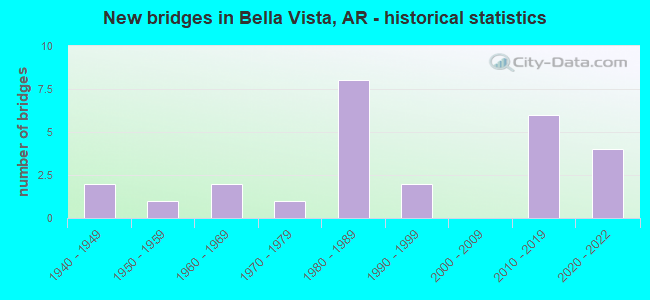
- New bridges - historical statistics
- 21940-1949
- 11950-1959
- 21960-1969
- 11970-1979
- 81980-1989
- 21990-1999
- 62010-2019
- 42020-2022


- Bridge Condition - Deck
- 23.5%Very good
- 47.1%Good
- 5.9%Satisfactory
- 17.6%Fair
- 5.9%Poor

- Bridge Condition - Superstructure
- 5.9%Excellent
- 41.2%Very good
- 17.6%Good
- 17.6%Satisfactory
- 17.6%Fair

- Bridge Condition - Substructure
- 5.9%Excellent
- 23.5%Very good
- 35.3%Good
- 5.9%Satisfactory
- 29.4%Fair

- Bridge Condition - Channel
- 5.3%Excellent
- 10.5%Very good
- 57.9%Good
- 21.1%Satisfactory
- 5.3%Fair

- Bridge Condition - Culverts
- 22.2%Very good
- 33.3%Good
- 11.1%Satisfactory
- 22.2%Fair
- 11.1%Poor
Find on map >> Show street view
Structure Number: 2157, Location: 2 MI S JCT SH 340- US 71 (Lat: 36.446928, Lng: -94.239169), Route carried "on" structure: US 71, Year Built: 1940, Year Reconstructed: 1976, Status: Open, Structure Length: 9.72m (31.89ft), Average Daily Traffic: 37,000 (year 2018), Truck Traffic: 1%, Average Future Daily Traffic: 47,900 (year 2038), Design Load: HS 20, Features Intersected: LITTLE SUGAR CREEK
Minimum Vertical Clearance: 30+ m (98+ ft), Kilometerpoint: 4.329, Lanes on structure: 4, Base Highway Network: Yes, Owner: State Highway Agency, Approaching Roadway Width: 21.9m (71.9ft), Skew: 22 degrees, Material/Design: Steel continuous, Design/Construction: Stringer/Multi-beam, Number Of Spans In Main Unit: 3, Number Of Approach Spans: 3, Length of Maximum Span: 22.9m (75.1ft), Curb-To-Curb Width: 26.5m (86.9ft), Out-to-Out Width: 27.4m (89.9ft)
Condition: Deck: Satisfactory, Superstructure: Satisfactory, Substructure: Fair, Channel: Satisfactory, Operating Rating: 47.2 metric tons, Method Used To Determine Operating Rating: Load Factor (LF), Inventory Rating: 28.1 metric tons, Method Used To Determine Inventory Rating: Load Factor (LF), Structural Evaluation: Somewhat better than minimum adequacy, Deck Geometry: Superior to present desirable criteria, Waterway Adequacy: Equal to present desirable criteria, Approach Roadway Alignment: Equal to present desirable criteria, Designated Inspection Frequency: Every 24 months, Critical Feature Inspection Frequency: Every 24 months, Inspection Date: May 2020, Deck Structure Type: Concrete Cast-file-Place, Wearing Surface/Protective System: Wearing Surface: Monolithic Concrete
Find on map >> Show street view
Structure Number: 2158, Location: .25 MI S JCT SH 340-US 71 (Lat: 36.470969, Lng: -94.243981), Route carried "on" structure: US 71, Year Built: 1940, Year Reconstructed: 1976, Status: Open, Structure Length: 2.87m (9.42ft), Average Daily Traffic: 34,000 (year 2018), Truck Traffic: 1%, Average Future Daily Traffic: 47,950 (year 2028), Design Load: HS 20, Features Intersected: PINION CR
Minimum Vertical Clearance: 30+ m (98+ ft), Kilometerpoint: 7.194, Lanes on structure: 4, Base Highway Network: Yes, Owner: State Highway Agency, Approaching Roadway Width: 21.9m (71.9ft), Skew: 23 degrees, Material/Design: Concrete, Design/Construction: Slab, Number Of Spans In Main Unit: 3, Length of Maximum Span: 9.8m (32.2ft), Curb-To-Curb Width: 26.5m (86.9ft), Out-to-Out Width: 27.4m (89.9ft)
Condition: Deck: Fair, Superstructure: Fair, Substructure: Good, Channel: Good, Operating Rating: 52.6 metric tons, Method Used To Determine Operating Rating: Load Factor (LF), Inventory Rating: 31.8 metric tons, Method Used To Determine Inventory Rating: Load Factor (LF), Structural Evaluation: Somewhat better than minimum adequacy, Deck Geometry: Superior to present desirable criteria, Waterway Adequacy: Equal to present desirable criteria, Approach Roadway Alignment: Equal to present desirable criteria, Designated Inspection Frequency: Every 24 months, Critical Feature Inspection Frequency: Every 24 months, Inspection Date: May 2020, Deck Structure Type: Concrete Cast-file-Place, Wearing Surface/Protective System: Wearing Surface: Monolithic Concrete
Find on map >> Show street view
Structure Number: 4711, Location: 0.1 MI E US 71 (Lat: 36.438822, Lng: -94.234731), Route carried "on" structure: City street 38187, Year Built: 1998, Status: Open, Structure Length: 11.03m (36.19ft), Average Daily Traffic: 8,200 (year 2018), Truck Traffic: 2%, Average Future Daily Traffic: 1,763 (year 2017), Design Load: HS 20, Features Intersected: LITTLE SUGAR CREEK, Facility Carried by Structure: Mercy Way-Benton
Minimum Vertical Clearance: 30+ m (98+ ft), Kilometerpoint: 0.129, Lanes on structure: 2, Owner: City or Municipal Highway Agency, Approaching Roadway Width: 6.7m (22.0ft), Skew: 2 degrees, Material/Design: Steel, Design/Construction: Stringer/Multi-beam, Number Of Spans In Main Unit: 5, Length of Maximum Span: 21.9m (71.9ft), Curb-To-Curb Width: 8.5m (27.9ft), Out-to-Out Width: 9.4m (30.8ft)
Condition: Deck: Good, Superstructure: Good, Substructure: Good, Channel: Good, Operating Rating: 54.4 metric tons, Method Used To Determine Operating Rating: Load Factor (LF), Inventory Rating: 32.7 metric tons, Method Used To Determine Inventory Rating: Load Factor (LF), Structural Evaluation: Better than present minimum criteria, Deck Geometry: Meets minimum limits, Waterway Adequacy: Superior to present desirable criteria, Approach Roadway Alignment: Equal to present desirable criteria, Designated Inspection Frequency: Every 24 months, Critical Feature Inspection Frequency: Every 24 months, Inspection Date: August 2020, Deck Structure Type: Concrete Cast-file-Place, Wearing Surface/Protective System: Wearing Surface: Monolithic Concrete
Find on map >> Show street view
Structure Number: 5155, Location: .10 SW JCT SH 340-US 71 (Lat: 36.475289, Lng: -94.250508), Route carried "on" structure: State highway 340, Year Built: 1967, Year Reconstructed: 1975, Status: Open, Structure Length: 8.75m (28.71ft), Average Daily Traffic: 12,000 (year 2018), Truck Traffic: 1%, Average Future Daily Traffic: 18,334 (year 2028), Design Load: H 20, Features Intersected: LITTLE SUGAR CREEK
Minimum Vertical Clearance: 30+ m (98+ ft), Kilometerpoint: 6.663, Lanes on structure: 3, Owner: State Highway Agency, Approaching Roadway Width: 12.2m (40.0ft), Material/Design: Steel, Design/Construction: Stringer/Multi-beam, Number Of Spans In Main Unit: 5, Length of Maximum Span: 17.4m (57.1ft), Curb or Sidewalk Widths: Left: 0.5m (1.6ft), Right: 0.0m, Curb-To-Curb Width: 12.8m (42.0ft), Out-to-Out Width: 14.3m (46.9ft)
Condition: Deck: Poor, Superstructure: Fair, Substructure: Fair, Channel: Good, Operating Rating: 46.3 metric tons, Method Used To Determine Operating Rating: Load Factor (LF), Inventory Rating: 27.2 metric tons, Method Used To Determine Inventory Rating: Load Factor (LF), Structural Evaluation: Somewhat better than minimum adequacy, Deck Geometry: Meets minimum limits, Waterway Adequacy: Equal to present desirable criteria, Approach Roadway Alignment: Equal to present desirable criteria, Designated Inspection Frequency: Every 24 months, Critical Feature Inspection Frequency: Every 24 months, Other Special Inspection Frequency: Every 24 months, Inspection Date: May 2020, Other Special Inspection Date: May 2021, Deck Structure Type: Concrete Cast-file-Place, Wearing Surface/Protective System: Wearing Surface: Bituminous
Find on map >> Show street view
Structure Number: 5614, Location: 4.26 MI NE JCT SH 279-340 (Lat: 36.475650, Lng: -94.248319), Route carried "on" structure: State highway 340, Year Built: 1976, Status: Open, Structure Length: 4.18m (13.71ft), Average Daily Traffic: 9,806 (year 2018), Truck Traffic: 1%, Average Future Daily Traffic: 18,334 (year 2028), Design Load: HS 20, Features Intersected: US 71-SEC 19
Minimum Vertical Clearance: 30+ m (98+ ft), Kilometerpoint: 6.856, Lanes on structure: 3, Lanes under structure: 5, Owner: State Highway Agency, Approaching Roadway Width: 12.8m (42.0ft), Material/Design: Steel continuous, Design/Construction: Stringer/Multi-beam, Number Of Spans In Main Unit: 2, Length of Maximum Span: 20.7m (67.9ft), Curb-To-Curb Width: 15.2m (49.9ft), Out-to-Out Width: 16.2m (53.1ft)
Condition: Deck: Fair, Superstructure: Satisfactory, Substructure: Fair, Operating Rating: 54.4 metric tons, Method Used To Determine Operating Rating: Load Factor (LF), Inventory Rating: 32.7 metric tons, Method Used To Determine Inventory Rating: Load Factor (LF), Structural Evaluation: Somewhat better than minimum adequacy, Deck Geometry: Equal to present minimum criteria, Underclear: Better than present minimum criteria, Approach Roadway Alignment: Equal to present desirable criteria, Designated Inspection Frequency: Every 24 months, Critical Feature Inspection Frequency: Every 24 months, Inspection Date: May 2020, Deck Structure Type: Concrete Cast-file-Place, Wearing Surface/Protective System: Wearing Surface: Monolithic Concrete
Find on map >> Show street view
Structure Number: 7275, Location: 0.98 M SW of CR 39 (Lat: 36.411861, Lng: -94.278619), Route carried "on" structure: County highway 49, Year Built: 2014, Status: Open, Structure Length: 6.46m (21.19ft), Average Daily Traffic: 272 (year 2017), Truck Traffic: 1%, Average Future Daily Traffic: 170 (year 2037), Design Load: HL 93, Features Intersected: SH 549 Mn Lns
Minimum Vertical Clearance: 30.17m (98.98ft), Kilometerpoint: 1.577, Lanes on structure: 2, Lanes under structure: 2, Owner: State Highway Agency, Approaching Roadway Width: 8.7m (28.5ft), Material/Design: Steel continuous, Design/Construction: Stringer/Multi-beam, Number Of Spans In Main Unit: 2, Length of Maximum Span: 33.5m (109.9ft), Curb-To-Curb Width: 8.5m (27.9ft), Out-to-Out Width: 9.5m (31.2ft)
Condition: Deck: Good, Superstructure: Very good, Substructure: Very good, Operating Rating: 47.2 metric tons, Method Used To Determine Operating Rating: Load and Resistance Factor (LRFR), Inventory Rating: 32.7 metric tons, Method Used To Determine Inventory Rating: Load and Resistance Factor (LRFR), Structural Evaluation: Equal to present desirable criteria, Deck Geometry: Equal to present minimum criteria, Underclear: Equal to present minimum criteria, Approach Roadway Alignment: Equal to present desirable criteria, Designated Inspection Frequency: Every 24 months, Critical Feature Inspection Frequency: Every 24 months, Inspection Date: May 2021, Deck Structure Type: Concrete Cast-file-Place, Wearing Surface/Protective System: Deck Protection: Epoxy Coated Reinforcing
Find on map >> Show street view
Structure Number: 17801, Location: 2 MI SE BELLA VISTA (Lat: 36.430467, Lng: -94.204503), Route carried "on" structure: County highway 40, Year Built: 1950, Status: Open, Structure Length: 1.25m (4.10ft), Average Daily Traffic: 9,700 (year 2015), Truck Traffic: 1%, Average Future Daily Traffic: 9,500 (year 2030), Features Intersected: SPANKER CREEK
Minimum Vertical Clearance: 30+ m (98+ ft), Kilometerpoint: 1.996, Lanes on structure: 2, Owner: County Highway Agency, Approaching Roadway Width: 6.1m (20.0ft), Skew: 3 degrees, Material/Design: Concrete, Design/Construction: Culvert, Number Of Spans In Main Unit: 3, Length of Maximum Span: 4.3m (14.1ft)
Condition: Channel: Good, Culverts: Satisfactory, Operating Rating: 29.0 metric tons, Method Used To Determine Operating Rating: Load Factor (LF), Inventory Rating: 17.2 metric tons, Method Used To Determine Inventory Rating: Load Factor (LF), Structural Evaluation: Meets minimum limits, Waterway Adequacy: Equal to present desirable criteria, Approach Roadway Alignment: Equal to present minimum criteria, Designated Inspection Frequency: Every 24 months, Critical Feature Inspection Frequency: Every 24 months, Inspection Date: Febuary 2021
Find on map >> Show street view
Structure Number: 20885, Location: 0.8 MI E CO RD 40 (Lat: 36.429961, Lng: -94.195111), Route carried "on" structure: County highway 1766, Year Built: 1990, Status: Open, Structure Length: 0.94m (3.08ft), Average Daily Traffic: 36 (year 2018), Truck Traffic: 1%, Average Future Daily Traffic: 21 (year 2007), Features Intersected: SPANKER CREEK
Minimum Vertical Clearance: 30+ m (98+ ft), Kilometerpoint: 0.016, Lanes on structure: 2, Owner: County Highway Agency, Approaching Roadway Width: 6.1m (20.0ft), Material/Design: Concrete, Design/Construction: Channel Beam, Number Of Spans In Main Unit: 1, Length of Maximum Span: 8.8m (28.9ft), Curb or Sidewalk Widths: Left: 0.3m (1.0ft), Right: 0.3m (1.0ft), Curb-To-Curb Width: 7.4m (24.3ft), Out-to-Out Width: 8.0m (26.2ft)
Condition: Deck: Good, Superstructure: Good, Substructure: Good, Channel: Satisfactory, Operating Rating: 43.5 metric tons, Method Used To Determine Operating Rating: Load Factor (LF), Inventory Rating: 26.3 metric tons, Method Used To Determine Inventory Rating: Load Factor (LF), Structural Evaluation: Equal to present minimum criteria, Deck Geometry: Equal to present minimum criteria, Waterway Adequacy: Better than present minimum criteria, Approach Roadway Alignment: Equal to present desirable criteria, Designated Inspection Frequency: Every 24 months, Critical Feature Inspection Frequency: Every 24 months, Inspection Date: October 2021, Deck Structure Type: Concrete Precast Panels, Wearing Surface/Protective System: Wearing Surface: Bituminous
Find on map >> Show street view
Structure Number: 23039, Location: .05 MI S JCT SCOTSDALE DR (Lat: 36.491889, Lng: -94.302969), Route carried "on" structure: City street 37478, Year Built: 1980, Status: Open, Structure Length: 0.64m (2.10ft), Average Daily Traffic: 772 (year 2018), Average Future Daily Traffic: 71 (year 2020), Features Intersected: BRANCH, Facility Carried by Structure: MckenzieDR B Vista
Minimum Vertical Clearance: 30+ m (98+ ft), Kilometerpoint: 0.080, Lanes on structure: 2, Owner: City or Municipal Highway Agency, Approaching Roadway Width: 5.5m (18.0ft), Material/Design: Steel, Design/Construction: Culvert, Number Of Spans In Main Unit: 4, Length of Maximum Span: 1.2m (3.9ft)
Condition: Channel: Good, Culverts: Fair, Operating Rating: 54.4 metric tons, Method Used To Determine Operating Rating: Load Factor (LF), Inventory Rating: 32.7 metric tons, Method Used To Determine Inventory Rating: Load Factor (LF), Structural Evaluation: Somewhat better than minimum adequacy, Waterway Adequacy: Meets minimum limits, Approach Roadway Alignment: Better than present minimum criteria, Designated Inspection Frequency: Every 24 months, Critical Feature Inspection Frequency: Every 24 months, Inspection Date: January 2021
Find on map >> Show street view
Structure Number: 23095, Location: 2.5 MI S W SH 279 (Lat: 36.442064, Lng: -94.327017), Route carried "on" structure: City street 26282, Year Built: 2015, Status: Open, Structure Length: 0.76m (2.49ft), Average Daily Traffic: 5,600 (year 2018), Truck Traffic: 2%, Average Future Daily Traffic: 1,128 (year 2020), Features Intersected: BRANCH, Facility Carried by Structure: B Vista Highland
Minimum Vertical Clearance: 30+ m (98+ ft), Kilometerpoint: 4.023, Lanes on structure: 2, Owner: City or Municipal Highway Agency, Approaching Roadway Width: 6.1m (20.0ft), Skew: 1 degrees, Material/Design: Steel, Design/Construction: Culvert, Number Of Spans In Main Unit: 4, Length of Maximum Span: 1.5m (4.9ft)
Condition: Channel: Good, Culverts: Good, Operating Rating: 54.4 metric tons, Method Used To Determine Operating Rating: Load Factor (LF), Inventory Rating: 32.7 metric tons, Method Used To Determine Inventory Rating: Load Factor (LF), Structural Evaluation: Better than present minimum criteria, Waterway Adequacy: Somewhat better than minimum adequacy, Approach Roadway Alignment: Better than present minimum criteria, Designated Inspection Frequency: Every 24 months, Critical Feature Inspection Frequency: Every 24 months, Inspection Date: January 2022
Find on map >> Show street view
Structure Number: 23096, Location: 4.0 MI S W S H 279_ (Lat: 36.451228, Lng: -94.348494), Route carried "on" structure: City street 26282, Year Built: 1980, Status: Open, Structure Length: 0.64m (2.10ft), Average Daily Traffic: 1,900 (year 2018), Truck Traffic: 3%, Average Future Daily Traffic: 2,700 (year 2038), Features Intersected: BRANCH, Facility Carried by Structure: HI LNDS BLVD B VST
Minimum Vertical Clearance: 30+ m (98+ ft), Kilometerpoint: 6.437, Lanes on structure: 2, Owner: City or Municipal Highway Agency, Approaching Roadway Width: 6.1m (20.0ft), Material/Design: Concrete, Design/Construction: Culvert, Number Of Spans In Main Unit: 2, Length of Maximum Span: 3.0m (9.8ft)
Condition: Channel: Good, Culverts: Good, Operating Rating: 26.3 metric tons, Method Used To Determine Operating Rating: Load Factor (LF), Inventory Rating: 16.3 metric tons, Method Used To Determine Inventory Rating: Load Factor (LF), Structural Evaluation: Meets minimum limits, Waterway Adequacy: Equal to present desirable criteria, Approach Roadway Alignment: Equal to present desirable criteria, Designated Inspection Frequency: Every 24 months, Critical Feature Inspection Frequency: Every 24 months, Inspection Date: Febuary 2021
Find on map >> Show street view
Structure Number: 23097, Location: 4.1 MI S W S H 279_ (Lat: 36.451617, Lng: -94.349150), Route carried "on" structure: City street 26282, Year Built: 1980, Status: Open, Structure Length: 0.73m (2.40ft), Average Daily Traffic: 1,900 (year 2018), Truck Traffic: 3%, Average Future Daily Traffic: 2,700 (year 2038), Features Intersected: BRANCH, Facility Carried by Structure: HI LNDS BLVD B VST
Minimum Vertical Clearance: 30+ m (98+ ft), Kilometerpoint: 6.598, Lanes on structure: 2, Owner: City or Municipal Highway Agency, Approaching Roadway Width: 6.1m (20.0ft), Skew: 3 degrees, Material/Design: Concrete, Design/Construction: Culvert, Number Of Spans In Main Unit: 2, Length of Maximum Span: 3.7m (12.1ft)
Condition: Channel: Good, Culverts: Good, Operating Rating: 26.3 metric tons, Method Used To Determine Operating Rating: Load Factor (LF), Inventory Rating: 16.3 metric tons, Method Used To Determine Inventory Rating: Load Factor (LF), Structural Evaluation: Meets minimum limits, Waterway Adequacy: Equal to present desirable criteria, Approach Roadway Alignment: Equal to present desirable criteria, Designated Inspection Frequency: Every 24 months, Critical Feature Inspection Frequency: Every 24 months, Inspection Date: Febuary 2021
Find on map >> Show street view
Structure Number: 23098, Location: 4.9 MI S W S H 279 (Lat: 36.455747, Lng: -94.363656), Route carried "on" structure: City street 26282, Year Built: 1980, Status: Open, Structure Length: 2.16m (7.09ft), Average Daily Traffic: 1,900 (year 2018), Truck Traffic: 3%, Average Future Daily Traffic: 2,700 (year 2038), Features Intersected: BRANCH, Facility Carried by Structure: B Vista Highlands
Minimum Vertical Clearance: 30+ m (98+ ft), Kilometerpoint: 7.886, Lanes on structure: 2, Owner: City or Municipal Highway Agency, Approaching Roadway Width: 6.1m (20.0ft), Skew: 3 degrees, Material/Design: Steel, Design/Construction: Culvert, Number Of Spans In Main Unit: 7, Length of Maximum Span: 2.4m (7.9ft)
Condition: Channel: Fair, Culverts: Poor, Operating Rating: 54.4 metric tons, Method Used To Determine Operating Rating: Load Factor (LF), Inventory Rating: 32.7 metric tons, Method Used To Determine Inventory Rating: Load Factor (LF), Structural Evaluation: Meets minimum limits, Waterway Adequacy: Better than present minimum criteria, Approach Roadway Alignment: Equal to present desirable criteria, Designated Inspection Frequency: Every 24 months, Critical Feature Inspection Frequency: Every 24 months, Inspection Date: March 2021
Find on map >> Show street view
Structure Number: 23099, Location: 5.1 MI SW SH 279 (Lat: 36.456358, Lng: -94.366661), Route carried "on" structure: City street 26282, Year Built: 1980, Status: Open, Structure Length: 0.91m (2.99ft), Average Daily Traffic: 1,900 (year 2018), Truck Traffic: 3%, Average Future Daily Traffic: 2,700 (year 2038), Features Intersected: BRANCH, Facility Carried by Structure: B Vista Highlands
Minimum Vertical Clearance: 30+ m (98+ ft), Kilometerpoint: 8.208, Lanes on structure: 2, Owner: City or Municipal Highway Agency, Approaching Roadway Width: 6.1m (20.0ft), Material/Design: Steel, Design/Construction: Culvert, Number Of Spans In Main Unit: 4, Length of Maximum Span: 2.1m (6.9ft)
Condition: Channel: Satisfactory, Culverts: Fair, Operating Rating: 54.4 metric tons, Method Used To Determine Operating Rating: Load Factor (LF), Inventory Rating: 32.7 metric tons, Method Used To Determine Inventory Rating: Load Factor (LF), Structural Evaluation: Somewhat better than minimum adequacy, Waterway Adequacy: Better than present minimum criteria, Approach Roadway Alignment: Better than present minimum criteria, Designated Inspection Frequency: Every 24 months, Critical Feature Inspection Frequency: Every 24 months, Inspection Date: March 2021
Find on map >> Show street view
Structure Number: 23102, Location: 0.95 MI JCT HIGHLANDS BLV (Lat: 36.473997, Lng: -94.314078), Route carried "on" structure: City street 22519, Year Built: 1980, Status: Open, Structure Length: 1.37m (4.49ft), Average Daily Traffic: 4,000 (year 2018), Truck Traffic: 2%, Average Future Daily Traffic: 1,410 (year 2020), Features Intersected: GORDON HOLLOW BRANCH, Facility Carried by Structure: GLASGOW RD B Vist
Minimum Vertical Clearance: 30+ m (98+ ft), Kilometerpoint: 1.529, Lanes on structure: 2, Owner: City or Municipal Highway Agency, Approaching Roadway Width: 6.4m (21.0ft), Material/Design: Concrete, Design/Construction: Channel Beam, Number Of Spans In Main Unit: 1, Length of Maximum Span: 13.4m (44.0ft), Curb or Sidewalk Widths: Left: 0.2m (0.7ft), Right: 0.2m (0.7ft), Curb-To-Curb Width: 8.3m (27.2ft), Out-to-Out Width: 8.9m (29.2ft)
Condition: Deck: Good, Superstructure: Satisfactory, Substructure: Satisfactory, Channel: Satisfactory, Operating Rating: 41.7 metric tons, Method Used To Determine Operating Rating: Load Factor (LF), Inventory Rating: 25.4 metric tons, Method Used To Determine Inventory Rating: Load Factor (LF), Structural Evaluation: Equal to present minimum criteria, Deck Geometry: High priority of corrective action, Waterway Adequacy: Equal to present desirable criteria, Approach Roadway Alignment: Equal to present minimum criteria, Designated Inspection Frequency: Every 24 months, Critical Feature Inspection Frequency: Every 24 months, Inspection Date: January 2021, Deck Structure Type: Concrete Precast Panels, Wearing Surface/Protective System: Wearing Surface: Monolithic Concrete
Find on map >> Show street view
Structure Number: 23103, Location: 0.02 MI JCT SCOTSDALE (Lat: 36.488158, Lng: -94.298608), Route carried "on" structure: City street 14167, Year Built: 1984, Status: Open, Structure Length: 2.83m (9.28ft), Average Daily Traffic: 696 (year 2018), Truck Traffic: 1%, Average Future Daily Traffic: 141 (year 2020), Design Load: H 20, Features Intersected: GORDON HOLLOW BRANCH, Facility Carried by Structure: CULEN HLS DR B Vst
Minimum Vertical Clearance: 30+ m (98+ ft), Kilometerpoint: 0.032, Lanes on structure: 2, Owner: City or Municipal Highway Agency, Approaching Roadway Width: 6.7m (22.0ft), Material/Design: Concrete, Design/Construction: Channel Beam, Number Of Spans In Main Unit: 3, Length of Maximum Span: 9.4m (30.8ft), Curb-To-Curb Width: 7.5m (24.6ft), Out-to-Out Width: 8.3m (27.2ft)
Condition: Deck: Fair, Superstructure: Fair, Substructure: Fair, Channel: Good, Operating Rating: 46.3 metric tons, Method Used To Determine Operating Rating: Load Factor (LF), Inventory Rating: 28.1 metric tons, Method Used To Determine Inventory Rating: Load Factor (LF), Structural Evaluation: Somewhat better than minimum adequacy, Deck Geometry: Meets minimum limits, Waterway Adequacy: Equal to present desirable criteria, Approach Roadway Alignment: Better than present minimum criteria, Designated Inspection Frequency: Every 24 months, Critical Feature Inspection Frequency: Every 24 months, Inspection Date: January 2021, Deck Structure Type: Concrete Precast Panels, Wearing Surface/Protective System: Wearing Surface: Monolithic Concrete
Find on map >> Show street view
Structure Number: 23726, Location: 1.5 M N GLASGOW RD (Lat: 36.489056, Lng: -94.298728), Route carried "on" structure: City street 51745, Year Built: 2015, Status: Open, Structure Length: 0.70m (2.30ft), Average Daily Traffic: 1,100 (year 2018), Truck Traffic: 3%, Average Future Daily Traffic: 540 (year 2020), Features Intersected: BRANCH - Bella Vista, Facility Carried by Structure: SCOTSDLE DR
Minimum Vertical Clearance: 30+ m (98+ ft), Kilometerpoint: 2.494, Lanes on structure: 2, Owner: City or Municipal Highway Agency, Approaching Roadway Width: 6.1m (20.0ft), Material/Design: Concrete, Design/Construction: Culvert, Number Of Spans In Main Unit: 2, Length of Maximum Span: 3.4m (11.2ft)
Condition: Channel: Good, Culverts: Very good, Operating Rating: 33.6 metric tons, Method Used To Determine Operating Rating: Load Factor (LF), Inventory Rating: 20.0 metric tons, Method Used To Determine Inventory Rating: Load Factor (LF), Structural Evaluation: Somewhat better than minimum adequacy, Waterway Adequacy: Better than present minimum criteria, Approach Roadway Alignment: Better than present minimum criteria, Designated Inspection Frequency: Every 24 months, Critical Feature Inspection Frequency: Every 24 months, Inspection Date: January 2021
Find on map >> Show street view
Structure Number: 24097, Location: .05 MI N JCT C R 40 (Lat: 36.430950, Lng: -94.208519), Route carried "on" structure: County highway 43, Year Built: 2019, Status: Open, Structure Length: 3.14m (10.30ft), Average Daily Traffic: 600 (year 2020), Truck Traffic: 5%, Average Future Daily Traffic: 720 (year 2040), Design Load: HL 93, Features Intersected: Spanker creek
Minimum Vertical Clearance: 30+ m (98+ ft), Kilometerpoint: 0.080, Lanes on structure: 2, Owner: County Highway Agency, Approaching Roadway Width: 10.4m (34.1ft), Material/Design: Steel continuous, Design/Construction: Stringer/Multi-beam, Number Of Spans In Main Unit: 3, Length of Maximum Span: 12.2m (40.0ft), Curb-To-Curb Width: 10.4m (34.1ft), Out-to-Out Width: 11.6m (38.1ft)
Condition: Deck: Good, Superstructure: Very good, Substructure: Very good, Channel: Very good, Operating Rating: 54.4 metric tons, Method Used To Determine Operating Rating: Load and Resistance Factor (LRFR), Inventory Rating: 32.7 metric tons, Method Used To Determine Inventory Rating: Load and Resistance Factor (LRFR), Structural Evaluation: Equal to present desirable criteria, Deck Geometry: Equal to present minimum criteria, Waterway Adequacy: Better than present minimum criteria, Approach Roadway Alignment: Better than present minimum criteria, Designated Inspection Frequency: Every 24 months, Critical Feature Inspection Frequency: Every 24 months, Inspection Date: October 2021, Deck Structure Type: Concrete Cast-file-Place, Wearing Surface/Protective System: Wearing Surface: Monolithic Concrete, Deck Protection: Epoxy Coated Reinforcing
Find on map >> Show street view
Structure Number: 24168, Location: 0.1 MI S JCT HIGHLANDS (Lat: 36.453931, Lng: -94.359619), Route carried "on" structure: City street 12947, Year Built: 1980, Status: Open, Structure Length: 1.07m (3.51ft), Average Daily Traffic: 40 (year 2000), Truck Traffic: 1%, Average Future Daily Traffic: 56 (year 2020), Features Intersected: BRANCH, Facility Carried by Structure: B.Vista Copinsa DR
Minimum Vertical Clearance: 30+ m (98+ ft), Kilometerpoint: 0.080, Lanes on structure: 2, Owner: City or Municipal Highway Agency, Approaching Roadway Width: 6.7m (22.0ft), Material/Design: Steel, Design/Construction: Culvert, Number Of Spans In Main Unit: 5, Length of Maximum Span: 1.7m (5.6ft)
Condition: Channel: Excellent, Culverts: Very good, Operating Rating: 54.4 metric tons, Method Used To Determine Operating Rating: Load and Resistance Factor (LRFR), Inventory Rating: 32.7 metric tons, Method Used To Determine Inventory Rating: Load and Resistance Factor (LRFR), Structural Evaluation: Equal to present desirable criteria, Waterway Adequacy: Better than present minimum criteria, Approach Roadway Alignment: Better than present minimum criteria, Designated Inspection Frequency: Every 24 months, Critical Feature Inspection Frequency: Every 24 months, Inspection Date: March 2021
Find on map >> Show street view
Structure Number: A7218, Location: 0.16 S. of state line (Lat: 36.497458, Lng: -94.381528), Route carried "on" structure: State highway 49, Year Built: 2020, Status: Open, Structure Length: 7.01m (23.00ft), Average Daily Traffic: 2,600 (year 2020), Average Future Daily Traffic: 3,120 (year 2040), Design Load: HL 93, Features Intersected: Edinburgh Rd
Minimum Vertical Clearance: 30.17m (98.98ft), Kilometerpoint: 0.000, Lanes on structure: 2, Lanes under structure: 2, Owner: State Highway Agency, Approaching Roadway Width: 12.2m (40.0ft), Skew: 3 degrees, Material/Design: Steel continuous, Design/Construction: Stringer/Multi-beam, Number Of Spans In Main Unit: 3, Length of Maximum Span: 26.5m (86.9ft), Curb-To-Curb Width: 12.2m (40.0ft), Out-to-Out Width: 13.4m (44.0ft)
Condition: Deck: Good, Superstructure: Very good, Substructure: Very good, Operating Rating: 49.0 metric tons, Method Used To Determine Operating Rating: Load and Resistance Factor (LRFR), Inventory Rating: 28.1 metric tons, Method Used To Determine Inventory Rating: Load and Resistance Factor (LRFR), Structural Evaluation: Better than present minimum criteria, Deck Geometry: Better than present minimum criteria, Underclear: Superior to present desirable criteria, Approach Roadway Alignment: Equal to present desirable criteria, Designated Inspection Frequency: Every 24 months, Critical Feature Inspection Frequency: Every 24 months, Inspection Date: Febuary 2021, Deck Structure Type: Concrete Cast-file-Place, Wearing Surface/Protective System: Wearing Surface: Monolithic Concrete, Deck Protection: Epoxy Coated Reinforcing
Find on map >> Show street view
Structure Number: A7219, Location: 1.6 miles S of State line (Lat: 36.477828, Lng: -94.377289), Route carried "on" structure: State highway 49, Year Built: 2020, Status: Open, Structure Length: 10.03m (32.91ft), Average Daily Traffic: 2,600 (year 2020), Average Future Daily Traffic: 3,120 (year 2040), Design Load: HL 93, Features Intersected: CR 21
Minimum Vertical Clearance: 30.17m (98.98ft), Kilometerpoint: 0.000, Lanes on structure: 2, Lanes under structure: 1, Owner: State Highway Agency, Approaching Roadway Width: 12.2m (40.0ft), Skew: 3 degrees, Material/Design: Steel continuous, Design/Construction: Stringer/Multi-beam, Number Of Spans In Main Unit: 3, Length of Maximum Span: 37.8m (124.0ft), Curb-To-Curb Width: 12.2m (40.0ft), Out-to-Out Width: 13.4m (44.0ft)
Condition: Deck: Very good, Superstructure: Very good, Substructure: Good, Operating Rating: 45.4 metric tons, Method Used To Determine Operating Rating: Load and Resistance Factor (LRFR), Inventory Rating: 32.7 metric tons, Method Used To Determine Inventory Rating: Load and Resistance Factor (LRFR), Structural Evaluation: Better than present minimum criteria, Deck Geometry: Better than present minimum criteria, Underclear: Equal to present minimum criteria, Approach Roadway Alignment: Equal to present desirable criteria, Designated Inspection Frequency: Every 24 months, Critical Feature Inspection Frequency: Every 24 months, Inspection Date: Febuary 2021, Deck Structure Type: Concrete Cast-file-Place, Wearing Surface/Protective System: Wearing Surface: Monolithic Concrete, Deck Protection: Epoxy Coated Reinforcing
Find on map >> Show street view
Structure Number: B7218, Location: 0.16 S. of state line (Lat: 36.497444, Lng: -94.381911), Route carried "on" structure: State highway 49, Year Built: 2020, Status: Open, Structure Length: 7.01m (23.00ft), Average Daily Traffic: 2,600 (year 2020), Average Future Daily Traffic: 3,120 (year 2040), Design Load: HL 93, Features Intersected: Edinburgh Rd
Minimum Vertical Clearance: 30.17m (98.98ft), Kilometerpoint: 0.000, Lanes on structure: 2, Lanes under structure: 2, Base Highway Network: Yes, Owner: State Highway Agency, Approaching Roadway Width: 12.2m (40.0ft), Skew: 3 degrees, Material/Design: Steel continuous, Design/Construction: Stringer/Multi-beam, Number Of Spans In Main Unit: 3, Length of Maximum Span: 26.5m (86.9ft), Curb-To-Curb Width: 12.2m (40.0ft), Out-to-Out Width: 13.4m (44.0ft)
Condition: Deck: Very good, Superstructure: Very good, Substructure: Good, Operating Rating: 49.9 metric tons, Method Used To Determine Operating Rating: Load and Resistance Factor (LRFR), Inventory Rating: 32.7 metric tons, Method Used To Determine Inventory Rating: Load and Resistance Factor (LRFR), Structural Evaluation: Better than present minimum criteria, Deck Geometry: Better than present minimum criteria, Underclear: Superior to present desirable criteria, Approach Roadway Alignment: Equal to present desirable criteria, Designated Inspection Frequency: Every 24 months, Critical Feature Inspection Frequency: Every 24 months, Inspection Date: Febuary 2021, Deck Structure Type: Concrete Cast-file-Place, Wearing Surface/Protective System: Wearing Surface: Monolithic Concrete, Deck Protection: Epoxy Coated Reinforcing
Find on map >> Show street view
Structure Number: B7219, Location: 1.6 miles S of State line (Lat: 36.477642, Lng: -94.377664), Route carried "on" structure: State highway 49, Year Built: 2020, Status: Open, Structure Length: 10.03m (32.91ft), Average Daily Traffic: 2,600 (year 2020), Average Future Daily Traffic: 3,120 (year 2040), Design Load: HL 93, Features Intersected: CR 21
Minimum Vertical Clearance: 30.17m (98.98ft), Kilometerpoint: 0.000, Lanes on structure: 2, Lanes under structure: 2, Owner: State Highway Agency, Approaching Roadway Width: 12.2m (40.0ft), Skew: 3 degrees, Material/Design: Steel continuous, Design/Construction: Stringer/Multi-beam, Number Of Spans In Main Unit: 3, Length of Maximum Span: 37.8m (124.0ft), Curb-To-Curb Width: 12.2m (40.0ft), Out-to-Out Width: 13.4m (44.0ft)
Condition: Deck: Very good, Superstructure: Very good, Substructure: Good, Operating Rating: 45.4 metric tons, Method Used To Determine Operating Rating: Load and Resistance Factor (LRFR), Inventory Rating: 32.7 metric tons, Method Used To Determine Inventory Rating: Load and Resistance Factor (LRFR), Structural Evaluation: Better than present minimum criteria, Deck Geometry: Better than present minimum criteria, Underclear: Equal to present minimum criteria, Approach Roadway Alignment: Equal to present desirable criteria, Designated Inspection Frequency: Every 24 months, Critical Feature Inspection Frequency: Every 24 months, Inspection Date: Febuary 2021, Deck Structure Type: Concrete Cast-file-Place, Wearing Surface/Protective System: Wearing Surface: Monolithic Concrete, Deck Protection: Epoxy Coated Reinforcing
Find on map >> Show street view
Structure Number: B7274, Location: 3.66 mi West of US71 (Lat: 36.412219, Lng: -94.285531), Route carried "on" structure: State highway 49, Year Built: 2014, Status: Open, Structure Length: 16.98m (55.71ft), Average Daily Traffic: 5,700 (year 2018), Truck Traffic: 5%, Average Future Daily Traffic: 22,000 (year 2034), Design Load: HL 93, Features Intersected: CR49/Beckett Rd &Tanyard
Minimum Vertical Clearance: 30.44m (99.87ft), Kilometerpoint: 5.890, Lanes on structure: 2, Lanes under structure: 2, Base Highway Network: Yes, Owner: State Highway Agency, Approaching Roadway Width: 12.4m (40.7ft), Skew: 3 degrees, Material/Design: Steel continuous, Design/Construction: Stringer/Multi-beam, Number Of Spans In Main Unit: 5, Length of Maximum Span: 35.1m (115.2ft), Curb-To-Curb Width: 12.2m (40.0ft), Out-to-Out Width: 13.2m (43.3ft)
Condition: Deck: Good, Superstructure: Very good, Substructure: Very good, Channel: Very good, Operating Rating: 45.4 metric tons, Method Used To Determine Operating Rating: Load and Resistance Factor (LRFR), Inventory Rating: 32.7 metric tons, Method Used To Determine Inventory Rating: Load and Resistance Factor (LRFR), Structural Evaluation: Equal to present desirable criteria, Deck Geometry: Somewhat better than minimum adequacy, Underclear: Superior to present desirable criteria, Waterway Adequacy: Superior to present desirable criteria, Approach Roadway Alignment: Equal to present desirable criteria, Designated Inspection Frequency: Every 24 months, Critical Feature Inspection Frequency: Every 24 months, Inspection Date: June 2021, Deck Structure Type: Concrete Cast-file-Place, Wearing Surface/Protective System: Wearing Surface: Monolithic Concrete, Deck Protection: Epoxy Coated Reinforcing
Find on map >> Show street view
Structure Number: B7276, Location: 2.4 Mi W of Jct US 71 (Lat: 36.411161, Lng: -94.262850), Route carried "on" structure: State highway 49, Year Built: 2014, Status: Open, Structure Length: 5.74m (18.83ft), Average Daily Traffic: 5,700 (year 2018), Truck Traffic: 5%, Average Future Daily Traffic: 22,000 (year 2034), Design Load: HL 93, Features Intersected: Punkin Hollow Rd
Minimum Vertical Clearance: 30.17m (98.98ft), Kilometerpoint: 3.862, Lanes on structure: 2, Lanes under structure: 2, Owner: State Highway Agency, Approaching Roadway Width: 12.8m (42.0ft), Skew: 2 degrees, Material/Design: Steel continuous, Design/Construction: Stringer/Multi-beam, Number Of Spans In Main Unit: 3, Length of Maximum Span: 23.8m (78.1ft), Curb-To-Curb Width: 13.0m (42.7ft), Out-to-Out Width: 13.1m (43.0ft)
Condition: Deck: Very good, Superstructure: Excellent, Substructure: Excellent, Operating Rating: 54.4 metric tons, Method Used To Determine Operating Rating: Load and Resistance Factor (LRFR), Inventory Rating: 32.7 metric tons, Method Used To Determine Inventory Rating: Load and Resistance Factor (LRFR), Structural Evaluation: Superior to present desirable criteria, Deck Geometry: Somewhat better than minimum adequacy, Underclear: Superior to present desirable criteria, Approach Roadway Alignment: Equal to present desirable criteria, Designated Inspection Frequency: Every 24 months, Critical Feature Inspection Frequency: Every 24 months, Inspection Date: June 2021, Deck Structure Type: Concrete Cast-file-Place, Wearing Surface/Protective System: Deck Protection: Epoxy Coated Reinforcing
Find on map >> Show street view
Structure Number: M323, Location: .4 MI SW JCT SH 340-US 71 (Lat: 36.476611, Lng: -94.254169), Route carried "on" structure: State highway 340, Year Built: 1967, Status: Open, Structure Length: 0.94m (3.08ft), Average Daily Traffic: 7,835 (year 2018), Truck Traffic: 1%, Average Future Daily Traffic: 18,334 (year 2028), Design Load: H 15, Features Intersected: TANYARD CREEK
Minimum Vertical Clearance: 30+ m (98+ ft), Kilometerpoint: 6.260, Lanes on structure: 2, Owner: State Highway Agency, Approaching Roadway Width: 7.6m (24.9ft), Material/Design: Concrete, Design/Construction: Channel Beam, Number Of Spans In Main Unit: 1, Length of Maximum Span: 8.5m (27.9ft), Curb or Sidewalk Widths: Left: 0.2m (0.7ft), Right: 0.2m (0.7ft), Curb-To-Curb Width: 7.4m (24.3ft), Out-to-Out Width: 8.0m (26.2ft)
Condition: Deck: Good, Superstructure: Good, Substructure: Fair, Channel: Good, Operating Rating: 54.4 metric tons, Method Used To Determine Operating Rating: Load Factor (LF), Inventory Rating: 32.7 metric tons, Method Used To Determine Inventory Rating: Load Factor (LF), Structural Evaluation: Somewhat better than minimum adequacy, Deck Geometry: High priority of replacement, Waterway Adequacy: Equal to present desirable criteria, Approach Roadway Alignment: Equal to present desirable criteria, Length Of Structure Improvement: 1.65m (5.41ft), Designated Inspection Frequency: Every 24 months, Critical Feature Inspection Frequency: Every 24 months, Inspection Date: August 2021, Roadway Improvement Cost: $125,000, Total Project Cost: $248,000, Deck Structure Type: Concrete Precast Panels, Wearing Surface/Protective System: Wearing Surface: Bituminous
Find on map >> Show street view
Structure Number: 5614, Location: 4.26 MI NE JCT SH 279-340 (Lat: 36.475650, Lng: -94.248319), Route carried "under" structure: US 71, Structure Length: 0. m, Average Daily Traffic: 17,000 (year 2014), Truck Traffic: 1%, Features Intersected: US 71-SEC 19, Facility Carried by Structure: SH 340 Benton1
Minimum Vertical Clearance: 5.21m (17.09ft), Kilometerpoint: 7.821, Length of Maximum Span: 0.0m
Find on map >> Show street view
Structure Number: 5614, Location: 4.26 MI NE JCT SH 279-340 (Lat: 36.475650, Lng: -94.248319), Route carried "under" structure: US 71, Structure Length: 0. m, Average Daily Traffic: 17,000 (year 2014), Truck Traffic: 1%, Features Intersected: US 71-SEC 19, Facility Carried by Structure: SH 340 Benton1
Minimum Vertical Clearance: 6.27m (20.57ft), Kilometerpoint: 7.821, Length of Maximum Span: 0.0m
Find on map >> Show street view
Structure Number: 722, Location: 2.4 M N JCT 549 & 72 (Lat: 36.464889, Lng: -94.379039), Route carried "under" structure: State highway 549, Structure Length: 0. m, Average Daily Traffic: 181 (year 2013), Features Intersected: SH 549 Sec 9, Facility Carried by Structure: CR 34 Benton Co.
Minimum Vertical Clearance: 5.07m (16.63ft), Length of Maximum Span: 0.0m
Find on map >> Show street view
Structure Number: 722, Location: 2.4 M N JCT 549 & 72 (Lat: 36.464889, Lng: -94.379039), Route carried "under" structure: State highway 549, Structure Length: 0. m, Average Daily Traffic: 181 (year 2013), Features Intersected: SH 549 Sec 9, Facility Carried by Structure: CR 34 Benton Co.
Minimum Vertical Clearance: 5.10m (16.73ft), Length of Maximum Span: 0.0m
Find on map >> Show street view
Structure Number: 7275, Location: 0.98 M SW of CR 39 (Lat: 36.411861, Lng: -94.278619), Route carried "under" structure: State highway 549, Structure Length: 0. m, Average Daily Traffic: 12,000 (year 2014), Truck Traffic: 20%, Features Intersected: SH 549, Facility Carried by Structure: CR49/Miller Church
Minimum Vertical Clearance: 5.45m (17.88ft), Kilometerpoint: 5.440, Length of Maximum Span: 0.0m
Find on map >> Show street view
Structure Number: A7218, Location: 0.16 S. of state line (Lat: 36.497458, Lng: -94.381528), Route carried "under" structure: County highway EDINB, Structure Length: 0. m, Average Daily Traffic: 1 (year 0000), Features Intersected: 549, Facility Carried by Structure: US 49
Minimum Vertical Clearance: 9.32m (30.58ft), Kilometerpoint: 0.000, Length of Maximum Span: 0.0m
Find on map >> Show street view
Structure Number: A7219, Location: 1.6 miles S of State line (Lat: 36.477828, Lng: -94.377289), Route carried "under" structure: Other road CR21, Structure Length: 0. m, Features Intersected: 549, Facility Carried by Structure: US 49
Minimum Vertical Clearance: 10.54m (34.58ft), Kilometerpoint: 0.000, Length of Maximum Span: 0.0m
Find on map >> Show street view
Structure Number: B7218, Location: 0.16 S. of state line (Lat: 36.497444, Lng: -94.381911), Route carried "under" structure: County highway EDINB, Structure Length: 0. m, Average Daily Traffic: 1 (year 0000), Features Intersected: 549, Facility Carried by Structure: US 49
Minimum Vertical Clearance: 11.06m (36.29ft), Kilometerpoint: 0.000, Length of Maximum Span: 0.0m
Find on map >> Show street view
Structure Number: B7219, Location: 1.6 miles S of State line (Lat: 36.477642, Lng: -94.377664), Route carried "under" structure: Other road CR21, Structure Length: 0. m, Features Intersected: 549, Facility Carried by Structure: US 49
Minimum Vertical Clearance: 9.84m (32.28ft), Kilometerpoint: 0.000, Length of Maximum Span: 0.0m
Find on map >> Show street view
Structure Number: B7274, Location: 3.66 mi West of US71 (Lat: 36.412219, Lng: -94.285531), Route carried "under" structure: County highway 49, Structure Length: 0. m, Average Daily Traffic: 12,000 (year 2017), Truck Traffic: 20%, Features Intersected: Beckett Rd (CR49)
Minimum Vertical Clearance: 12.46m (40.88ft), Kilometerpoint: 5.890, Length of Maximum Span: 0.0m
Find on map >> Show street view
Structure Number: B7276, Location: 2.4 Mi W of Jct US 71 (Lat: 36.411161, Lng: -94.262850), Route carried "under" structure: City street 39, Structure Length: 0. m, Average Daily Traffic: 100 (year 2014), Truck Traffic: 1%, Features Intersected: Punkin Hollow Rd, Facility Carried by Structure: US 49
Minimum Vertical Clearance: 6.78m (22.24ft), Kilometerpoint: 3.058, Length of Maximum Span: 0.0m