Bridge Statistics for Beachwood, New Jersey (NJ)
Condition, Traffic, Stress, Structural Evaluation, Project Costs
- National Bridge Inventory (NBI) Statistics
- 13Number of bridges
- 69ft / 21.4mTotal length
- 259,782Total average daily traffic
- 9,227Total average daily truck traffic
- National Bridge Inventory (NBI) Registered Bridges for Beachwood
- No street view available for this location
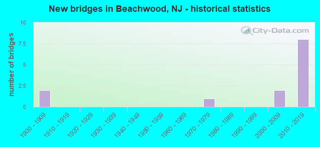
- New bridges - historical statistics
- 21900-1909
- 11970-1979
- 22000-2009
- 82010-2019


- Bridge Condition - Deck
- 12.5%Very good
- 75.0%Good
- 12.5%Satisfactory

- Bridge Condition - Superstructure
- 11.1%Very good
- 66.7%Good
- 22.2%Satisfactory

- Bridge Condition - Substructure
- 66.7%Good
- 22.2%Satisfactory
- 11.1%Fair

- Bridge Condition - Channel
- 20.0%Very good
- 40.0%Good
- 40.0%Satisfactory
Find on map >> Show street view
Structure Number: 1505005, Location: DOUBLE TROUBLE STATE PARK (Lat: 39.893931, Lng: -74.225219), Route carried "on" structure: State lands road , Year Built: 1975, Status: Open, Structure Length: 1.52m (4.99ft), Average Daily Traffic: 29 (year 2020), Truck Traffic: 3%, Average Future Daily Traffic: 35 (year 2040), Design Load: HS 20, Features Intersected: CEDAR CREEK, Facility Carried by Structure: Double Trouble Rd
Minimum Vertical Clearance: 30+ m (98+ ft), Kilometerpoint: 0.000, Lanes on structure: 1, Owner: State Park, Forest, or Reservation Agency, Maintenance Responsibility: County Highway Agency, Approaching Roadway Width: 6.7m (22.0ft), Material/Design: Wood or Timber, Design/Construction: Stringer/Multi-beam, Number Of Spans In Main Unit: 3, Length of Maximum Span: 4.9m (16.1ft), Curb-To-Curb Width: 4.7m (15.4ft), Out-to-Out Width: 5.1m (16.7ft)
Condition: Deck: Satisfactory, Superstructure: Good, Substructure: Fair, Channel: Good, Operating Rating: 33.6 metric tons, Method Used To Determine Operating Rating: Allowable Stress (AS), Inventory Rating: 24.5 metric tons, Method Used To Determine Inventory Rating: Allowable Stress (AS), Structural Evaluation: Somewhat better than minimum adequacy, Deck Geometry: Better than present minimum criteria, Waterway Adequacy: Equal to present desirable criteria, Approach Roadway Alignment: Meets minimum limits, Designated Inspection Frequency: Every 24 months, Inspection Date: April 2020, Deck Structure Type: Wood or Timber, Wearing Surface/Protective System: Wearing Surface: Wood or Timber
Find on map >> Show street view
Structure Number: 336715, Location: DOUBLE TROUBLE STATE PARK (Lat: 39.886311, Lng: -74.214581), Route carried "on" structure: State lands road , Year Built: 1900, Year Reconstructed: 1982, Status: Open, Structure Length: 0.85m (2.79ft), Average Daily Traffic: 9 (year 2021), Average Future Daily Traffic: 10 (year 2041), Features Intersected: CEDAR CREEK, Facility Carried by Structure: NEW GUINEA ROAD
Minimum Vertical Clearance: 30+ m (98+ ft), Kilometerpoint: 0.000, Lanes on structure: 1, Owner: State Agenciy, Approaching Roadway Width: 3.7m (12.1ft), Design/Construction: Stringer/Multi-beam, Number Of Spans In Main Unit: 2, Length of Maximum Span: 3.4m (11.2ft), Curb or Sidewalk Widths: Left: 1.2m (3.9ft), Right: 0.2m (0.7ft), Curb-To-Curb Width: 3.7m (12.1ft), Out-to-Out Width: 5.2m (17.1ft)
Condition: Deck: Good, Superstructure: Satisfactory, Substructure: Satisfactory, Channel: Satisfactory, Operating Rating: 29.0 metric tons, Method Used To Determine Operating Rating: Allowable Stress (AS), Inventory Rating: 20.9 metric tons, Method Used To Determine Inventory Rating: Allowable Stress (AS), Structural Evaluation: Equal to present minimum criteria, Deck Geometry: Meets minimum limits, Waterway Adequacy: Superior to present desirable criteria, Approach Roadway Alignment: Equal to present desirable criteria, Designated Inspection Frequency: Every 24 months, Inspection Date: August 2021, Deck Structure Type: Wood or Timber
Find on map >> Show street view
Structure Number: 3367151, Location: DOUBLE TROUBLE STATE PARK (Lat: 39.899569, Lng: -74.229919), Route carried "on" structure: State lands road , Year Built: 1900, Year Reconstructed: 1982, Status: Open, Structure Length: 0.70m (2.30ft), Average Daily Traffic: 12 (year 2021), Average Future Daily Traffic: 14 (year 2041), Features Intersected: CEDAR CREEK, Facility Carried by Structure: COWS HEAD ROAD
Minimum Vertical Clearance: 30+ m (98+ ft), Kilometerpoint: 0.000, Lanes on structure: 1, Owner: State Agenciy, Approaching Roadway Width: 3.4m (11.2ft), Material/Design: Concrete, Design/Construction: Arch - Deck, Number Of Spans In Main Unit: 2, Length of Maximum Span: 3.0m (9.8ft), Curb or Sidewalk Widths: Left: 0.2m (0.7ft), Right: 0.2m (0.7ft), Curb-To-Curb Width: 3.3m (10.8ft), Out-to-Out Width: 3.8m (12.5ft)
Condition: Superstructure: Satisfactory, Substructure: Satisfactory, Channel: Satisfactory, Operating Rating: 24.5 metric tons, Method Used To Determine Operating Rating: Load Factor (LF), Inventory Rating: 14.5 metric tons, Method Used To Determine Inventory Rating: Load Factor (LF), Structural Evaluation: Meets minimum limits, Deck Geometry: High priority of replacement, Waterway Adequacy: Equal to present desirable criteria, Approach Roadway Alignment: Equal to present minimum criteria, Designated Inspection Frequency: Every 24 months, Inspection Date: August 2021
Find on map >> Show street view
Structure Number: 360768N, Location: 0.5 MI S OF CR618&GSP JCT (Lat: 39.884500, Lng: -74.212078), Route carried "on" structure: Other road GSP, Year Built: 2009, Status: Open, Structure Length: 2.71m (8.89ft), Average Daily Traffic: 44,121 (year 2021), Truck Traffic: 3%, Average Future Daily Traffic: 53,837 (year 2041), Design Load: HL 93, Features Intersected: CEDAR CREEK
Minimum Vertical Clearance: 30+ m (98+ ft), Kilometerpoint: 123.646, Lanes on structure: 3, Base Highway Network: Yes, Toll: On toll road, Owner: State Toll Authority, Approaching Roadway Width: 18.3m (60.0ft), Skew: 2 degrees, Material/Design: Prestressed concrete, Design/Construction: Stringer/Multi-beam, Number Of Spans In Main Unit: 1, Length of Maximum Span: 25.6m (84.0ft), Curb-To-Curb Width: 18.3m (60.0ft), Out-to-Out Width: 19.4m (63.6ft)
Condition: Deck: Good, Superstructure: Good, Substructure: Good, Channel: Very good, Operating Rating: 90.7 metric tons, Method Used To Determine Operating Rating: Load and Resistance Factor Rating (LRFR) rating reported by rating factor(RF) method using HL-93 loadings, Inventory Rating: 62.9 metric tons, Method Used To Determine Inventory Rating: Load and Resistance Factor Rating (LRFR) rating reported by rating factor(RF) method using HL-93 loadings, Structural Evaluation: Better than present minimum criteria, Deck Geometry: Better than present minimum criteria, Waterway Adequacy: Equal to present desirable criteria, Approach Roadway Alignment: Equal to present desirable criteria, Designated Inspection Frequency: Every 24 months, Inspection Date: Febuary 2021, Deck Structure Type: Concrete Cast-file-Place, Wearing Surface/Protective System: Wearing Surface: Monolithic Concrete, Deck Protection: Epoxy Coated Reinforcing
Find on map >> Show street view
Structure Number: 360768S, Location: 0.5 MI S OF CR618&GSP JCT (Lat: 39.884881, Lng: -74.212711), Route carried "on" structure: Other road GSP, Year Built: 2009, Status: Open, Structure Length: 2.71m (8.89ft), Average Daily Traffic: 43,393 (year 2021), Truck Traffic: 3%, Average Future Daily Traffic: 52,948 (year 2041), Design Load: HL 93, Features Intersected: CEDAR CREEK
Minimum Vertical Clearance: 30+ m (98+ ft), Kilometerpoint: 123.646, Lanes on structure: 3, Base Highway Network: Yes, Toll: On toll road, Owner: State Toll Authority, Approaching Roadway Width: 18.3m (60.0ft), Skew: 2 degrees, Material/Design: Prestressed concrete, Design/Construction: Stringer/Multi-beam, Number Of Spans In Main Unit: 1, Length of Maximum Span: 25.6m (84.0ft), Curb-To-Curb Width: 18.3m (60.0ft), Out-to-Out Width: 19.4m (63.6ft)
Condition: Deck: Good, Superstructure: Very good, Substructure: Good, Channel: Good, Operating Rating: 89.7 metric tons, Method Used To Determine Operating Rating: Load and Resistance Factor Rating (LRFR) rating reported by rating factor(RF) method using HL-93 loadings, Inventory Rating: 61.9 metric tons, Method Used To Determine Inventory Rating: Load and Resistance Factor Rating (LRFR) rating reported by rating factor(RF) method using HL-93 loadings, Structural Evaluation: Better than present minimum criteria, Deck Geometry: Better than present minimum criteria, Waterway Adequacy: Equal to present desirable criteria, Approach Roadway Alignment: Equal to present desirable criteria, Designated Inspection Frequency: Every 24 months, Inspection Date: Febuary 2021, Deck Structure Type: Concrete Cast-file-Place, Wearing Surface/Protective System: Wearing Surface: Monolithic Concrete, Deck Protection: Epoxy Coated Reinforcing
Find on map >> Show street view
Structure Number: 360774N, Location: 2 MI S OF RT614&GSP JCT (Lat: 39.892522, Lng: -74.212197), Route carried "on" structure: Other road GSP, Year Built: 2011, Status: Open, Structure Length: 2.93m (9.61ft), Average Daily Traffic: 42,500 (year 2021), Truck Traffic: 3%, Average Future Daily Traffic: 53,250 (year 2041), Design Load: HL 93, Features Intersected: PINEWALD-KESWICK RD(618)
Minimum Vertical Clearance: 30+ m (98+ ft), Kilometerpoint: 124.563, Lanes on structure: 3, Lanes under structure: 2, Base Highway Network: Yes, Toll: On toll road, Owner: State Toll Authority, Approaching Roadway Width: 18.3m (60.0ft), Skew: 1 degrees, Material/Design: Steel, Design/Construction: Stringer/Multi-beam, Number Of Spans In Main Unit: 1, Length of Maximum Span: 27.4m (89.9ft), Curb-To-Curb Width: 18.3m (60.0ft), Out-to-Out Width: 19.4m (63.6ft)
Condition: Deck: Good, Superstructure: Good, Substructure: Good, Operating Rating: 54.8 metric tons, Method Used To Determine Operating Rating: Load and Resistance Factor Rating (LRFR) rating reported by rating factor(RF) method using HL-93 loadings, Inventory Rating: 42.1 metric tons, Method Used To Determine Inventory Rating: Load and Resistance Factor Rating (LRFR) rating reported by rating factor(RF) method using HL-93 loadings, Structural Evaluation: Better than present minimum criteria, Deck Geometry: Better than present minimum criteria, Underclear: Equal to present minimum criteria, Approach Roadway Alignment: Equal to present desirable criteria, Designated Inspection Frequency: Every 24 months, Inspection Date: Febuary 2021, Deck Structure Type: Concrete Cast-file-Place, Wearing Surface/Protective System: Wearing Surface: Monolithic Concrete, Deck Protection: Epoxy Coated Reinforcing
Find on map >> Show street view
Structure Number: 360774S, Location: 2 MI S OF RT614&GSP JCT (Lat: 39.892825, Lng: -74.212844), Route carried "on" structure: Other road GSP, Year Built: 2011, Status: Open, Structure Length: 3.32m (10.89ft), Average Daily Traffic: 39,400 (year 2021), Truck Traffic: 3%, Average Future Daily Traffic: 53,250 (year 2041), Design Load: HL 93, Features Intersected: PINEWALD-KESWICK RD(618)
Minimum Vertical Clearance: 30+ m (98+ ft), Kilometerpoint: 124.563, Lanes on structure: 3, Lanes under structure: 2, Base Highway Network: Yes, Toll: On toll road, Owner: State Toll Authority, Approaching Roadway Width: 18.3m (60.0ft), Skew: 3 degrees, Material/Design: Steel, Design/Construction: Stringer/Multi-beam, Number Of Spans In Main Unit: 1, Length of Maximum Span: 31.1m (102.0ft), Curb-To-Curb Width: 18.3m (60.0ft), Out-to-Out Width: 19.4m (63.6ft)
Condition: Deck: Good, Superstructure: Good, Substructure: Good, Operating Rating: 54.1 metric tons, Method Used To Determine Operating Rating: Load and Resistance Factor Rating (LRFR) rating reported by rating factor(RF) method using HL-93 loadings, Inventory Rating: 41.5 metric tons, Method Used To Determine Inventory Rating: Load and Resistance Factor Rating (LRFR) rating reported by rating factor(RF) method using HL-93 loadings, Structural Evaluation: Better than present minimum criteria, Deck Geometry: Better than present minimum criteria, Underclear: Equal to present minimum criteria, Approach Roadway Alignment: Equal to present desirable criteria, Designated Inspection Frequency: Every 24 months, Inspection Date: Febuary 2021, Deck Structure Type: Concrete Cast-file-Place, Wearing Surface/Protective System: Wearing Surface: Monolithic Concrete, Deck Protection: Epoxy Coated Reinforcing
Find on map >> Show street view
Structure Number: 360802N, Location: 2 MI S OF RT37 & GSP JCT (Lat: 39.933031, Lng: -74.208489), Route carried "on" structure: County highway 77, Year Built: 2011, Status: Open, Structure Length: 3.51m (11.52ft), Average Daily Traffic: 5,466 (year 2021), Truck Traffic: 3%, Average Future Daily Traffic: 6,686 (year 2041), Design Load: HL 93, Features Intersected: GSP NB
Minimum Vertical Clearance: 30+ m (98+ ft), Kilometerpoint: 0.676, Lanes on structure: 2, Lanes under structure: 3, Owner: State Toll Authority, Approaching Roadway Width: 13.4m (44.0ft), Skew: 4 degrees, Material/Design: Steel, Design/Construction: Stringer/Multi-beam, Number Of Spans In Main Unit: 1, Length of Maximum Span: 32.9m (107.9ft), Curb or Sidewalk Widths: Left: 1.8m (5.9ft), Right: 1.8m (5.9ft), Curb-To-Curb Width: 13.4m (44.0ft), Out-to-Out Width: 17.7m (58.1ft)
Condition: Deck: Very good, Superstructure: Good, Substructure: Good, Operating Rating: 56.1 metric tons, Method Used To Determine Operating Rating: Load and Resistance Factor Rating (LRFR) rating reported by rating factor(RF) method using HL-93 loadings, Inventory Rating: 43.1 metric tons, Method Used To Determine Inventory Rating: Load and Resistance Factor Rating (LRFR) rating reported by rating factor(RF) method using HL-93 loadings, Structural Evaluation: Better than present minimum criteria, Deck Geometry: Equal to present minimum criteria, Underclear: High priority of corrective action, Approach Roadway Alignment: Equal to present desirable criteria, Designated Inspection Frequency: Every 24 months, Inspection Date: Febuary 2021, Deck Structure Type: Concrete Cast-file-Place, Wearing Surface/Protective System: Wearing Surface: Monolithic Concrete, Deck Protection: Epoxy Coated Reinforcing
Find on map >> Show street view
Structure Number: 360802S, Location: 2 MI S OF RT37 & GSP JCT (Lat: 39.933486, Lng: -74.209325), Route carried "on" structure: County highway 77, Year Built: 2011, Status: Open, Structure Length: 3.11m (10.20ft), Average Daily Traffic: 5,466 (year 2021), Truck Traffic: 3%, Average Future Daily Traffic: 6,686 (year 2041), Design Load: HL 93, Features Intersected: GSP SB
Minimum Vertical Clearance: 30+ m (98+ ft), Kilometerpoint: 0.756, Lanes on structure: 2, Lanes under structure: 3, Owner: State Toll Authority, Approaching Roadway Width: 13.4m (44.0ft), Skew: 3 degrees, Material/Design: Steel, Design/Construction: Stringer/Multi-beam, Number Of Spans In Main Unit: 1, Length of Maximum Span: 29.3m (96.1ft), Curb or Sidewalk Widths: Left: 1.8m (5.9ft), Right: 1.8m (5.9ft), Curb-To-Curb Width: 13.4m (44.0ft), Out-to-Out Width: 17.7m (58.1ft)
Condition: Deck: Good, Superstructure: Good, Substructure: Good, Operating Rating: 58.6 metric tons, Method Used To Determine Operating Rating: Load and Resistance Factor Rating (LRFR) rating reported by rating factor(RF) method using HL-93 loadings, Inventory Rating: 45.0 metric tons, Method Used To Determine Inventory Rating: Load and Resistance Factor Rating (LRFR) rating reported by rating factor(RF) method using HL-93 loadings, Structural Evaluation: Better than present minimum criteria, Deck Geometry: Equal to present minimum criteria, Underclear: High priority of corrective action, Approach Roadway Alignment: Equal to present desirable criteria, Designated Inspection Frequency: Every 24 months, Inspection Date: Febuary 2021, Deck Structure Type: Concrete Cast-file-Place, Wearing Surface/Protective System: Wearing Surface: Monolithic Concrete, Deck Protection: Epoxy Coated Reinforcing
Find on map >> Show street view
Structure Number: 360774N, Location: 2 MI S OF RT614&GSP JCT (Lat: 39.892522, Lng: -74.212197), Route carried "under" structure: County highway 618, Year Built: 2011, Structure Length: 0. m, Average Daily Traffic: 3,693 (year 2021), Truck Traffic: 5%, Features Intersected: PINEWALD-KESWICK RD(618), Facility Carried by Structure: GSP NB
Minimum Vertical Clearance: 4.67m (15.32ft), Kilometerpoint: 11.282, Lanes on structure: 3, Lanes under structure: 2, Material/Design: Steel, Design/Construction: Stringer/Multi-beam, Length of Maximum Span: 27.4m (89.9ft)
Find on map >> Show street view
Structure Number: 360774S, Location: 2 MI S OF RT614&GSP JCT (Lat: 39.892825, Lng: -74.212844), Route carried "under" structure: County highway 618, Year Built: 2011, Structure Length: 0. m, Average Daily Traffic: 3,693 (year 2021), Truck Traffic: 1%, Features Intersected: PINEWALD-KESWICK RD(618), Facility Carried by Structure: GSP SB
Minimum Vertical Clearance: 4.72m (15.49ft), Kilometerpoint: 11.201, Lanes on structure: 3, Lanes under structure: 2, Material/Design: Steel, Design/Construction: Stringer/Multi-beam, Length of Maximum Span: 31.1m (102.0ft)
Find on map >> Show street view
Structure Number: 360802N, Location: 2 MI S OF RT37 & GSP JCT (Lat: 39.933031, Lng: -74.208489), Route carried "under" structure: Other road GSP, Year Built: 2011, Structure Length: 0. m, Average Daily Traffic: 36,000 (year 2021), Truck Traffic: 5%, Features Intersected: GSP NB, Facility Carried by Structure: BIRCH ST (CR 77)
Minimum Vertical Clearance: 5.39m (17.68ft), Kilometerpoint: 129.069, Lanes on structure: 2, Lanes under structure: 3, Toll: On toll road, Material/Design: Steel, Design/Construction: Stringer/Multi-beam, Length of Maximum Span: 32.9m (107.9ft)
Find on map >> Show street view
Structure Number: 360802S, Location: 2 MI S OF RT37 & GSP JCT (Lat: 39.933486, Lng: -74.209325), Route carried "under" structure: Other road GSP, Year Built: 2011, Structure Length: 0. m, Average Daily Traffic: 36,000 (year 2021), Truck Traffic: 5%, Features Intersected: GSP SB, Facility Carried by Structure: BIRCH ST (CR 77)
Minimum Vertical Clearance: 5.41m (17.75ft), Kilometerpoint: 129.069, Lanes on structure: 2, Lanes under structure: 3, Toll: On toll road, Material/Design: Steel, Design/Construction: Stringer/Multi-beam, Length of Maximum Span: 29.3m (96.1ft)