Bridge Statistics for Bayonne, New Jersey (NJ)
Condition, Traffic, Stress, Structural Evaluation, Project Costs
- National Bridge Inventory (NBI) Statistics
- 39Number of bridges
- 879ft / 268mTotal length
- $7,384,000Total costs
- 609,120Total average daily traffic
- 36,244Total average daily truck traffic
- National Bridge Inventory (NBI) Registered Bridges for Bayonne
- No street view available for this location
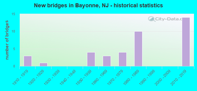
- New bridges - historical statistics
- 31910-1919
- 11920-1929
- 41950-1959
- 31960-1969
- 41970-1979
- 101980-1989
- 142010-2019

- Reconstructed bridges - Historical Statistics
- 11970-1979
- 01980-1989
- 11990-1999
- 12000-2009
- 12010-2019


- Bridge Condition - Deck
- 20.0%Very good
- 40.0%Good
- 20.0%Satisfactory
- 13.3%Fair
- 6.7%Poor

- Bridge Condition - Superstructure
- 5.6%Very good
- 50.0%Good
- 27.8%Satisfactory
- 11.1%Fair
- 5.6%Poor

- Bridge Condition - Substructure
- 11.1%Very good
- 27.8%Good
- 50.0%Satisfactory
- 11.1%Fair
Find on map >> Show street view
Structure Number: 900022, Location: BAYONNE PARK BAYONNE (Lat: 40.679861, Lng: -74.114639), Route carried "on" structure: City street , Year Built: 1916, Status: Open, Structure Length: 0.76m (2.49ft), Average Daily Traffic: 426 (year 2021), Truck Traffic: 1%, Average Future Daily Traffic: 511 (year 2041), Features Intersected: BAYONNE PARK FOOTPATH, Facility Carried by Structure: PARK ROAD
Minimum Vertical Clearance: 30+ m (98+ ft), Kilometerpoint: 0.000, Lanes on structure: 2, Owner: County Highway Agency, Approaching Roadway Width: 9.1m (29.9ft), Material/Design: Concrete, Design/Construction: Arch - Deck, Number Of Spans In Main Unit: 1, Length of Maximum Span: 7.6m (24.9ft), Curb or Sidewalk Widths: Left: 0.5m (1.6ft), Right: 2.5m (8.2ft), Curb-To-Curb Width: 9.1m (29.9ft), Out-to-Out Width: 12.7m (41.7ft)
Condition: Superstructure: Good, Substructure: Satisfactory, Operating Rating: 52.6 metric tons, Method Used To Determine Operating Rating: Field evaluation and documented engineering judgment, Inventory Rating: 31.8 metric tons, Method Used To Determine Inventory Rating: Field evaluation and documented engineering judgment, Structural Evaluation: Equal to present minimum criteria, Deck Geometry: Equal to present minimum criteria, Approach Roadway Alignment: Equal to present desirable criteria, Designated Inspection Frequency: Every 24 months, Inspection Date: Febuary 2021
Find on map >> Show street view
Structure Number: 900023, Location: BAYONNE PARK BAYONNE (Lat: 40.682289, Lng: -74.113511), Route carried "on" structure: City street , Year Built: 1916, Status: Open, Structure Length: 0.73m (2.40ft), Average Daily Traffic: 426 (year 2021), Truck Traffic: 1%, Average Future Daily Traffic: 511 (year 2041), Features Intersected: BAYONNE PARK FOOTPATH, Facility Carried by Structure: PARK ROAD
Minimum Vertical Clearance: 30+ m (98+ ft), Kilometerpoint: 0.000, Lanes on structure: 2, Owner: County Highway Agency, Approaching Roadway Width: 9.1m (29.9ft), Material/Design: Concrete, Design/Construction: Arch - Deck, Number Of Spans In Main Unit: 1, Length of Maximum Span: 7.3m (24.0ft), Curb or Sidewalk Widths: Left: 2.7m (8.9ft), Right: 0.2m (0.7ft), Curb-To-Curb Width: 9.1m (29.9ft), Out-to-Out Width: 12.7m (41.7ft)
Condition: Superstructure: Satisfactory, Substructure: Good, Operating Rating: 45.4 metric tons, Method Used To Determine Operating Rating: Field evaluation and documented engineering judgment, Inventory Rating: 26.3 metric tons, Method Used To Determine Inventory Rating: Field evaluation and documented engineering judgment, Structural Evaluation: Equal to present minimum criteria, Deck Geometry: Equal to present minimum criteria, Approach Roadway Alignment: Equal to present desirable criteria, Designated Inspection Frequency: Every 24 months, Inspection Date: Febuary 2021
Find on map >> Show street view
Structure Number: 900024, Location: BAYONNE PARK BAYONNE (Lat: 40.684211, Lng: -74.112289), Route carried "on" structure: City street , Year Built: 1916, Status: Open, Structure Length: 0.61m (2.00ft), Average Daily Traffic: 426 (year 2021), Truck Traffic: 1%, Average Future Daily Traffic: 511 (year 2041), Features Intersected: BAYONNE PARK FOOTPATH, Facility Carried by Structure: PARK ROAD
Minimum Vertical Clearance: 30+ m (98+ ft), Kilometerpoint: 0.000, Lanes on structure: 2, Owner: County Highway Agency, Approaching Roadway Width: 9.1m (29.9ft), Material/Design: Concrete, Design/Construction: Arch - Deck, Number Of Spans In Main Unit: 1, Length of Maximum Span: 6.1m (20.0ft), Curb or Sidewalk Widths: Left: 2.7m (8.9ft), Right: 0.3m (1.0ft), Curb-To-Curb Width: 9.1m (29.9ft), Out-to-Out Width: 12.7m (41.7ft)
Condition: Superstructure: Satisfactory, Substructure: Good, Operating Rating: 43.5 metric tons, Method Used To Determine Operating Rating: Field evaluation and documented engineering judgment, Inventory Rating: 26.3 metric tons, Method Used To Determine Inventory Rating: Field evaluation and documented engineering judgment, Structural Evaluation: Equal to present minimum criteria, Deck Geometry: Equal to present minimum criteria, Approach Roadway Alignment: Equal to present desirable criteria, Designated Inspection Frequency: Every 24 months, Inspection Date: Febuary 2021
Find on map >> Show street view
Structure Number: 913152, Location: 0.84 MI SOUTH OF I-78 JCT (Lat: 40.678211, Lng: -74.101700), Route carried "on" structure: City street , Year Built: 1960, Year Reconstructed: 1996, Status: Open, Structure Length: 6.31m (20.70ft), Average Daily Traffic: 2,605 (year 2021), Truck Traffic: 1%, Average Future Daily Traffic: 3,126 (year 2041), Design Load: HS 20, Features Intersected: NJ 440,CONRAIL&NJ TRNSIT, Facility Carried by Structure: CENTER STREET
Minimum Vertical Clearance: 30+ m (98+ ft), Kilometerpoint: 0.000, Lanes on structure: 2, Lanes under structure: 4, Owner: State Highway Agency, Approaching Roadway Width: 8.5m (27.9ft), Material/Design: Steel continuous, Design/Construction: Girder and Floorbeam System, Number Of Spans In Main Unit: 2, Length of Maximum Span: 36.9m (121.1ft), Curb or Sidewalk Widths: Left: 1.9m (6.2ft), Right: 0.0m, Curb-To-Curb Width: 8.5m (27.9ft), Out-to-Out Width: 9.0m (29.5ft)
Condition: Deck: Good, Superstructure: Good, Substructure: Satisfactory, Operating Rating: 49.9 metric tons, Method Used To Determine Operating Rating: Load Factor (LF), Inventory Rating: 29.9 metric tons, Method Used To Determine Inventory Rating: Load Factor (LF), Structural Evaluation: Equal to present minimum criteria, Deck Geometry: Meets minimum limits, Underclear: High priority of corrective action, Approach Roadway Alignment: Better than present minimum criteria, Length Of Structure Improvement: 6.31m (20.70ft), Designated Inspection Frequency: Every 24 months, Critical Feature Inspection Frequency: Every 24 months, Inspection Date: August 2021, Critical Feature Inspection Date: August 2021, Roadway Improvement Cost: $32,000, Total Project Cost: $69,000 ( Estimate for 2021), Deck Structure Type: Concrete Cast-file-Place, Wearing Surface/Protective System: Wearing Surface: Monolithic Concrete
Find on map >> Show street view
Structure Number: 913155, Location: .25 MI SOUTH OF I-78 (Lat: 40.691200, Lng: -74.103861), Route carried "on" structure: State highway 440, Year Built: 1971, Status: Open, Structure Length: 4.66m (15.29ft), Average Daily Traffic: 23,800 (year 2020), Truck Traffic: 4%, Average Future Daily Traffic: 29,040 (year 2040), Design Load: HS 20+Mod, Features Intersected: JFK BLVD (CR 501)
Minimum Vertical Clearance: 30+ m (98+ ft), Kilometerpoint: 37.337, Lanes on structure: 4, Lanes under structure: 5, Base Highway Network: Yes, Owner: State Highway Agency, Approaching Roadway Width: 16.2m (53.1ft), Material/Design: Steel, Design/Construction: Stringer/Multi-beam, Number Of Spans In Main Unit: 3, Length of Maximum Span: 31.1m (102.0ft), Curb or Sidewalk Widths: Left: 0.5m (1.6ft), Right: 0.5m (1.6ft), Curb-To-Curb Width: 16.2m (53.1ft), Out-to-Out Width: 17.8m (58.4ft)
Condition: Deck: Fair, Superstructure: Fair, Substructure: Satisfactory, Operating Rating: 62.6 metric tons, Method Used To Determine Operating Rating: Load Factor (LF), Inventory Rating: 37.2 metric tons, Method Used To Determine Inventory Rating: Load Factor (LF), Structural Evaluation: Somewhat better than minimum adequacy, Deck Geometry: Meets minimum limits, Underclear: Equal to present minimum criteria, Approach Roadway Alignment: Better than present minimum criteria, Designated Inspection Frequency: Every 24 months, Inspection Date: August 2020, Deck Structure Type: Concrete Cast-file-Place, Wearing Surface/Protective System: Wearing Surface: Monolithic Concrete
Find on map >> Show street view
Structure Number: 915151, Location: 03MI E OF NJTPK & 440 JCT (Lat: 40.696611, Lng: -74.107581), Route carried "on" structure: Ramp State highway 440, Year Built: 1972, Status: Open, Structure Length: 6.25m (20.51ft), Average Daily Traffic: 5,165 (year 2020), Truck Traffic: 4%, Average Future Daily Traffic: 6,305 (year 2040), Design Load: HS 20+Mod, Features Intersected: NJ 440, Facility Carried by Structure: WEST 63RD ST RAMPS
Minimum Vertical Clearance: 30+ m (98+ ft), Kilometerpoint: 38.656, Lanes on structure: 2, Lanes under structure: 6, Owner: State Highway Agency, Approaching Roadway Width: 14.6m (47.9ft), Skew: 31 degrees, Material/Design: Steel, Design/Construction: Stringer/Multi-beam, Number Of Spans In Main Unit: 2, Length of Maximum Span: 31.4m (103.0ft), Curb or Sidewalk Widths: Left: 0.5m (1.6ft), Right: 0.5m (1.6ft), Curb-To-Curb Width: 14.6m (47.9ft), Out-to-Out Width: 17.6m (57.7ft)
Condition: Deck: Satisfactory, Superstructure: Good, Substructure: Good, Operating Rating: 61.7 metric tons, Method Used To Determine Operating Rating: Load Factor (LF), Inventory Rating: 37.2 metric tons, Method Used To Determine Inventory Rating: Load Factor (LF), Structural Evaluation: Better than present minimum criteria, Deck Geometry: Superior to present desirable criteria, Underclear: Equal to present minimum criteria, Approach Roadway Alignment: Equal to present minimum criteria, Designated Inspection Frequency: Every 24 months, Inspection Date: July 2020, Deck Structure Type: Concrete Cast-file-Place, Wearing Surface/Protective System: Wearing Surface: Monolithic Concrete
Find on map >> Show street view
Structure Number: 921152, Location: 0.4 MI N OF BAYONNE BRDGE (Lat: 40.654269, Lng: -74.133700), Route carried "on" structure: State highway 440, Year Built: 1989, Status: Open, Structure Length: 5.49m (18.01ft), Average Daily Traffic: 13,200 (year 2020), Truck Traffic: 4%, Average Future Daily Traffic: 16,100 (year 2040), Design Load: HS 20+Mod, Features Intersected: JFK BOULEVARD (CR 501)
Minimum Vertical Clearance: 30+ m (98+ ft), Kilometerpoint: 30.433, Lanes on structure: 1, Lanes under structure: 4, Base Highway Network: Yes, Owner: State Highway Agency, Approaching Roadway Width: 12.2m (40.0ft), Skew: 35 degrees, Material/Design: Steel, Design/Construction: Stringer/Multi-beam, Number Of Spans In Main Unit: 2, Length of Maximum Span: 29.9m (98.1ft), Curb-To-Curb Width: 12.3m (40.4ft), Out-to-Out Width: 14.4m (47.2ft)
Condition: Deck: Satisfactory, Superstructure: Good, Substructure: Satisfactory, Inventory Rating: 58.1 metric tons, Method Used To Determine Inventory Rating: Load Factor (LF), Structural Evaluation: Equal to present minimum criteria, Deck Geometry: Somewhat better than minimum adequacy, Underclear: Somewhat better than minimum adequacy, Approach Roadway Alignment: Equal to present minimum criteria, Designated Inspection Frequency: Every 24 months, Inspection Date: March 2020, Deck Structure Type: Concrete Cast-file-Place, Wearing Surface/Protective System: Wearing Surface: Bituminous, Deck Protection: Epoxy Coated Reinforcing
Find on map >> Show street view
Structure Number: 921154, Location: 0.5M East OF BAYONNE BR (Lat: 40.653961, Lng: -74.129200), Route carried "on" structure: State highway 440, Year Built: 1989, Status: Open, Structure Length: 1.77m (5.81ft), Average Daily Traffic: 35,590 (year 2021), Truck Traffic: 5%, Average Future Daily Traffic: 42,700 (year 2041), Design Load: HS 20+Mod, Features Intersected: AVENUE C
Minimum Vertical Clearance: 30+ m (98+ ft), Kilometerpoint: 30.899, Lanes on structure: 4, Lanes under structure: 2, Base Highway Network: Yes, Owner: State Highway Agency, Approaching Roadway Width: 20.4m (66.9ft), Skew: 30 degrees, Material/Design: Steel, Design/Construction: Stringer/Multi-beam, Number Of Spans In Main Unit: 1, Length of Maximum Span: 15.8m (51.8ft), Curb-To-Curb Width: 20.4m (66.9ft), Out-to-Out Width: 22.1m (72.5ft)
Condition: Deck: Good, Superstructure: Good, Substructure: Good, Inventory Rating: 59.9 metric tons, Method Used To Determine Inventory Rating: Load Factor (LF), Structural Evaluation: Better than present minimum criteria, Deck Geometry: Superior to present desirable criteria, Underclear: Meets minimum limits, Approach Roadway Alignment: Equal to present desirable criteria, Designated Inspection Frequency: Every 24 months, Inspection Date: October 2021, Deck Structure Type: Concrete Cast-file-Place, Wearing Surface/Protective System: Wearing Surface: Bituminous, Deck Protection: Epoxy Coated Reinforcing
Find on map >> Show street view
Structure Number: 921156, Location: 1.0 ML NE OF BAYONNE BR (Lat: 40.653919, Lng: -74.126861), Route carried "on" structure: State highway 440, Year Built: 1988, Status: Open, Structure Length: 3.05m (10.01ft), Average Daily Traffic: 32,681 (year 2021), Truck Traffic: 4%, Average Future Daily Traffic: 39,206 (year 2041), Design Load: HS 20+Mod, Features Intersected: BROADWAY
Minimum Vertical Clearance: 30+ m (98+ ft), Kilometerpoint: 31.076, Lanes on structure: 4, Lanes under structure: 2, Base Highway Network: Yes, Owner: State Highway Agency, Approaching Roadway Width: 20.4m (66.9ft), Skew: 33 degrees, Material/Design: Steel, Design/Construction: Stringer/Multi-beam, Number Of Spans In Main Unit: 1, Length of Maximum Span: 28.3m (92.8ft), Curb-To-Curb Width: 20.4m (66.9ft), Out-to-Out Width: 22.1m (72.5ft)
Condition: Deck: Good, Superstructure: Good, Substructure: Satisfactory, Inventory Rating: 57.2 metric tons, Method Used To Determine Inventory Rating: Load Factor (LF), Structural Evaluation: Equal to present minimum criteria, Deck Geometry: Superior to present desirable criteria, Underclear: Better than present minimum criteria, Approach Roadway Alignment: Better than present minimum criteria, Designated Inspection Frequency: Every 24 months, Inspection Date: October 2021, Deck Structure Type: Concrete Cast-file-Place, Wearing Surface/Protective System: Wearing Surface: Bituminous, Deck Protection: Epoxy Coated Reinforcing
Find on map >> Show street view
Structure Number: 921158, Location: 2.6 Mi.S.of NJ Turnpike (Lat: 40.654319, Lng: -74.124661), Route carried "on" structure: State highway 440, Year Built: 1988, Status: Open, Structure Length: 2.71m (8.89ft), Average Daily Traffic: 31,690 (year 2020), Truck Traffic: 4%, Average Future Daily Traffic: 38,662 (year 2040), Design Load: HS 20+Mod, Features Intersected: LINNET STREET
Minimum Vertical Clearance: 30+ m (98+ ft), Kilometerpoint: 31.270, Lanes on structure: 4, Lanes under structure: 2, Base Highway Network: Yes, Owner: State Highway Agency, Approaching Roadway Width: 20.4m (66.9ft), Skew: 34 degrees, Material/Design: Steel, Design/Construction: Stringer/Multi-beam, Number Of Spans In Main Unit: 1, Length of Maximum Span: 24.7m (81.0ft), Curb-To-Curb Width: 20.4m (66.9ft), Out-to-Out Width: 22.1m (72.5ft)
Condition: Deck: Good, Superstructure: Good, Substructure: Satisfactory, Inventory Rating: 59.0 metric tons, Method Used To Determine Inventory Rating: Load Factor (LF), Structural Evaluation: Equal to present minimum criteria, Deck Geometry: Superior to present desirable criteria, Underclear: Equal to present minimum criteria, Approach Roadway Alignment: Equal to present desirable criteria, Designated Inspection Frequency: Every 24 months, Inspection Date: March 2020, Deck Structure Type: Concrete Cast-file-Place, Wearing Surface/Protective System: Wearing Surface: Bituminous, Deck Protection: Epoxy Coated Reinforcing
Find on map >> Show street view
Structure Number: 96315, Location: 1.31MI SW NJTPK EXIT 14A (Lat: 40.669639, Lng: -74.109500), Route carried "on" structure: City street , Year Built: 1969, Status: Posted for load, Structure Length: 2.41m (7.91ft), Average Daily Traffic: 8,426 (year 2021), Truck Traffic: 1%, Average Future Daily Traffic: 10,281 (year 2041), Features Intersected: HBLRT-BAYONNEBR&CONRAIL, Facility Carried by Structure: EAST 32ND STREET
Minimum Vertical Clearance: 30+ m (98+ ft), Kilometerpoint: 0.000, Lanes on structure: 2, Owner: State Agenciy, Approaching Roadway Width: 14.9m (48.9ft), Skew: 30 degrees, Material/Design: Steel, Design/Construction: Girder and Floorbeam System, Number Of Spans In Main Unit: 1, Length of Maximum Span: 22.6m (74.1ft), Curb or Sidewalk Widths: Left: 1.7m (5.6ft), Right: 1.7m (5.6ft), Curb-To-Curb Width: 12.2m (40.0ft), Out-to-Out Width: 13.6m (44.6ft)
Condition: Deck: Poor, Superstructure: Poor, Substructure: Satisfactory, Operating Rating: 26.3 metric tons, Method Used To Determine Operating Rating: Load Factor (LF), Inventory Rating: 15.4 metric tons, Method Used To Determine Inventory Rating: Load Factor (LF), Structural Evaluation: High priority of corrective action, Deck Geometry: Somewhat better than minimum adequacy, Underclear: High priority of corrective action, Approach Roadway Alignment: Equal to present minimum criteria, Bridge Posting: Required (Relationship of Operating Rating to Maximum Legal Load: 10.0 - 19.9% below), Length Of Structure Improvement: 2.44m (8.01ft), Designated Inspection Frequency: Every 24 months, Critical Feature Inspection Frequency: Every 24 months, Other Special Inspection Frequency: Every 12 months, Inspection Date: Febuary 2021, Critical Feature Inspection Date: Febuary 2021, Other Special Inspection Date: Febuary 2022, Bridge Improvement Cost: $2,832,000, Roadway Improvement Cost: $283,000, Total Project Cost: $6,115,000 ( Estimate for 2021), Deck Structure Type: Concrete Cast-file-Place, Wearing Surface/Protective System: Wearing Surface: Monolithic Concrete
Find on map >> Show street view
Structure Number: 122015, Location: 2.3 MI EAST OF NJTPK JCT (Lat: 40.266931, Lng: -74.466519), Route carried "on" structure: State highway 33, Year Built: 1926, Year Reconstructed: 1970, Status: Open, Structure Length: 0.88m (2.89ft), Average Daily Traffic: 33,007 (year 2021), Truck Traffic: 7%, Average Future Daily Traffic: 46,598 (year 2041), Design Load: HS 20, Features Intersected: BENTLEY'S BROOK
Minimum Vertical Clearance: 30+ m (98+ ft), Kilometerpoint: 27.842, Lanes on structure: 4, Base Highway Network: Yes, Owner: State Highway Agency, Approaching Roadway Width: 23.2m (76.1ft), Skew: 10 degrees, Material/Design: Concrete, Design/Construction: Slab, Number Of Spans In Main Unit: 2, Length of Maximum Span: 7.6m (24.9ft), Curb or Sidewalk Widths: Left: 1.8m (5.9ft), Right: 1.8m (5.9ft), Curb-To-Curb Width: 23.2m (76.1ft), Out-to-Out Width: 34.7m (113.8ft)
Condition: Deck: Fair, Superstructure: Fair, Substructure: Satisfactory, Channel: Good, Operating Rating: 31.8 metric tons, Method Used To Determine Operating Rating: Load Factor (LF), Inventory Rating: 19.1 metric tons, Method Used To Determine Inventory Rating: Load Factor (LF), Structural Evaluation: Meets minimum limits, Deck Geometry: Superior to present desirable criteria, Waterway Adequacy: Equal to present minimum criteria, Approach Roadway Alignment: Equal to present desirable criteria, Designated Inspection Frequency: Every 24 months, Underwater Inspection Frequency: Every 24 months, Inspection Date: December 2021, Underwater Inspection Date: March 2020, Deck Structure Type: Concrete Cast-file-Place, Wearing Surface/Protective System: Wearing Surface: Bituminous
Find on map >> Show street view
Structure Number: 3800076, Location: 2 MI. N. OF BAYONNE BRDG (Lat: 40.653839, Lng: -74.134700), Route carried "on" structure: Ramp State highway 440, Year Built: 1989, Status: Open, Structure Length: 6.04m (19.82ft), Average Daily Traffic: 8,126 (year 2021), Truck Traffic: 4%, Average Future Daily Traffic: 9,913 (year 2041), Design Load: HS 20+Mod, Features Intersected: J. F. KENNEDY BLVD
Minimum Vertical Clearance: 30+ m (98+ ft), Kilometerpoint: 30.433, Lanes on structure: 2, Lanes under structure: 4, Base Highway Network: Yes, Toll: Toll bridge is a segment, Owner: State Toll Authority, Approaching Roadway Width: 8.8m (28.9ft), Skew: 6 degrees, Material/Design: Steel, Design/Construction: Stringer/Multi-beam, Number Of Spans In Main Unit: 2, Length of Maximum Span: 29.6m (97.1ft), Curb-To-Curb Width: 8.8m (28.9ft), Out-to-Out Width: 9.9m (32.5ft)
Condition: Deck: Good, Superstructure: Good, Substructure: Satisfactory, Operating Rating: 84.4 metric tons, Method Used To Determine Operating Rating: Load Factor (LF), Inventory Rating: 50.8 metric tons, Method Used To Determine Inventory Rating: Load Factor (LF), Structural Evaluation: Equal to present minimum criteria, Deck Geometry: Meets minimum limits, Underclear: Meets minimum limits, Approach Roadway Alignment: Equal to present minimum criteria, Designated Inspection Frequency: Every 24 months, Inspection Date: May 2021, Deck Structure Type: Concrete Cast-file-Place, Wearing Surface/Protective System: Wearing Surface: Latex Concrete, Deck Protection: Epoxy Coated Reinforcing
Find on map >> Show street view
Structure Number: 382304A, Location: NJ 440 (Lat: 40.644289, Lng: -74.141281), Route carried "on" structure: Ramp State highway 440, Year Built: 2019, Status: Open, Structure Length: 89.31m (293.01ft), Average Daily Traffic: 26,420 (year 2021), Truck Traffic: 4%, Average Future Daily Traffic: 32,232 (year 2041), Design Load: HL 93, Features Intersected: W. 4th Street
Minimum Vertical Clearance: 30.18m (99.02ft), Kilometerpoint: 20.358, Lanes on structure: 2, Lanes under structure: 10, Base Highway Network: Yes, Toll: Toll bridge, Owner: Private, Approaching Roadway Width: 14.6m (47.9ft), Material/Design: Prestressed concrete continuous, Design/Construction: Segmental Box Girder, Number Of Spans In Main Unit: 14, Length of Maximum Span: 76.8m (252.0ft), Curb-To-Curb Width: 11.0m (36.1ft), Out-to-Out Width: 12.9m (42.3ft)
Condition: Deck: Very good, Superstructure: Good, Substructure: Very good, Operating Rating: 49.2 metric tons, Method Used To Determine Operating Rating: Load and Resistance Factor Rating (LRFR) rating reported by rating factor(RF) method using HL-93 loadings, Inventory Rating: 37.9 metric tons, Method Used To Determine Inventory Rating: Load and Resistance Factor Rating (LRFR) rating reported by rating factor(RF) method using HL-93 loadings, Structural Evaluation: Better than present minimum criteria, Deck Geometry: Better than present minimum criteria, Underclear: Equal to present desirable criteria, Approach Roadway Alignment: Superior to present desirable criteria, Designated Inspection Frequency: Every 24 months, Inspection Date: September 2021, Wearing Surface/Protective System: Wearing Surface: Monolithic Concrete
Find on map >> Show street view
Structure Number: 382304B, Location: Bayonne NB NJ Approach (Lat: 40.644150, Lng: -74.141261), Route carried "on" structure: State highway 440, Year Built: 2017, Status: Open, Structure Length: 89.31m (293.01ft), Average Daily Traffic: 26,420 (year 2021), Truck Traffic: 4%, Average Future Daily Traffic: 32,232 (year 2041), Design Load: HL 93, Features Intersected: W 4th Street
Minimum Vertical Clearance: 30.18m (99.02ft), Kilometerpoint: 20.342, Lanes on structure: 2, Lanes under structure: 10, Base Highway Network: Yes, Toll: Toll bridge, Owner: Private, Approaching Roadway Width: 14.6m (47.9ft), Skew: 20 degrees, Navigation Control: Yes ( Vertical Clearance: 30.2m (99.1ft), Horizontal Clearance: 30.2m (99.1ft)), Material/Design: Prestressed concrete continuous, Design/Construction: Segmental Box Girder, Number Of Spans In Main Unit: 14, Length of Maximum Span: 76.8m (252.0ft), Curb or Sidewalk Widths: Left: 2.0m (6.6ft), Right: 2.0m (6.6ft), Curb-To-Curb Width: 11.0m (36.1ft), Out-to-Out Width: 16.2m (53.1ft)
Condition: Deck: Very good, Superstructure: Satisfactory, Substructure: Good, Operating Rating: 85.5 metric tons, Method Used To Determine Operating Rating: Load and Resistance Factor Rating (LRFR) rating reported by rating factor(RF) method using HL-93 loadings, Inventory Rating: 38.2 metric tons, Method Used To Determine Inventory Rating: Load and Resistance Factor Rating (LRFR) rating reported by rating factor(RF) method using HL-93 loadings, Structural Evaluation: Equal to present minimum criteria, Deck Geometry: Somewhat better than minimum adequacy, Underclear: Equal to present desirable criteria, Approach Roadway Alignment: Superior to present desirable criteria, Designated Inspection Frequency: Every 24 months, Inspection Date: September 2021, Wearing Surface/Protective System: Wearing Surface: Monolithic Concrete
Find on map >> Show street view
Structure Number: N00201E, Location: 2 MI E NJTPK & HUD.CO.EXT (Lat: 40.692064, Lng: -74.107797), Route carried "on" structure: Interstate 78, Year Built: 1955, Year Reconstructed: 2014, Status: Open, Structure Length: 36.03m (118.21ft), Average Daily Traffic: 96,500 (year 2020), Truck Traffic: 10%, Average Future Daily Traffic: 117,700 (year 2040), Design Load: HS 20, Features Intersected: RTE 440, Facility Carried by Structure: NJ TPK HUD.CO.EXT.
Minimum Vertical Clearance: 30+ m (98+ ft), Kilometerpoint: 98.572, Lanes on structure: 4, Lanes under structure: 4, Base Highway Network: Yes, Toll: On toll road, Owner: State Toll Authority, Approaching Roadway Width: 23.2m (76.1ft), Skew: 30 degrees, Material/Design: Steel continuous, Design/Construction: Stringer/Multi-beam, Number Of Spans In Main Unit: 15, Length of Maximum Span: 24.1m (79.1ft), Curb-To-Curb Width: 22.3m (73.2ft), Out-to-Out Width: 24.3m (79.7ft)
Condition: Deck: Good, Superstructure: Satisfactory, Substructure: Fair, Operating Rating: 34.0 metric tons, Method Used To Determine Operating Rating: Load and Resistance Factor Rating (LRFR) rating reported by rating factor(RF) method using HL-93 loadings, Inventory Rating: 26.2 metric tons, Method Used To Determine Inventory Rating: Load and Resistance Factor Rating (LRFR) rating reported by rating factor(RF) method using HL-93 loadings, Structural Evaluation: Somewhat better than minimum adequacy, Deck Geometry: Superior to present desirable criteria, Underclear: High priority of corrective action, Approach Roadway Alignment: Equal to present desirable criteria, Length Of Structure Improvement: 36.03m (118.21ft), Designated Inspection Frequency: Every 24 months, Inspection Date: June 2020, Bridge Improvement Cost: $800,000, Roadway Improvement Cost: $200,000, Total Project Cost: $1,200,000 ( Estimate for 2018), Deck Structure Type: Concrete Precast Panels, Wearing Surface/Protective System: Deck Protection: Epoxy Coated Reinforcing
Find on map >> Show street view
Structure Number: N003, Location: .8 MI E OF NEWARK BAY (Lat: 40.691000, Lng: -74.104769), Route carried "on" structure: Interstate 78, Year Built: 1955, Year Reconstructed: 2016, Status: Open, Structure Length: 6.71m (22.01ft), Average Daily Traffic: 97,225 (year 2020), Truck Traffic: 10%, Average Future Daily Traffic: 118,600 (year 2040), Design Load: HS 20, Features Intersected: KENNEDY BLVD(CO.RTE.501), Facility Carried by Structure: NJ TPK HUD.CO.EXT.
Minimum Vertical Clearance: 30+ m (98+ ft), Kilometerpoint: 99.087, Lanes on structure: 4, Lanes under structure: 4, Base Highway Network: Yes, Toll: On toll road, Owner: State Toll Authority, Approaching Roadway Width: 23.2m (76.1ft), Skew: 30 degrees, Material/Design: Steel continuous, Design/Construction: Stringer/Multi-beam, Number Of Spans In Main Unit: 3, Length of Maximum Span: 31.7m (104.0ft), Curb-To-Curb Width: 23.2m (76.1ft), Out-to-Out Width: 26.9m (88.3ft)
Condition: Deck: Satisfactory, Superstructure: Satisfactory, Substructure: Fair, Operating Rating: 55.2 metric tons, Method Used To Determine Operating Rating: Load Factor (LF), Inventory Rating: 30.3 metric tons, Method Used To Determine Inventory Rating: Load Factor (LF), Structural Evaluation: Somewhat better than minimum adequacy, Deck Geometry: Superior to present desirable criteria, Underclear: Equal to present minimum criteria, Approach Roadway Alignment: Equal to present desirable criteria, Designated Inspection Frequency: Every 24 months, Inspection Date: June 2020, Deck Structure Type: Concrete Cast-file-Place, Wearing Surface/Protective System: Wearing Surface: Bituminous, Membrane: Other
Find on map >> Show street view
Structure Number: N00353E, Location: 0.2MI S OF I-78&NJ440 JCT (Lat: 40.679278, Lng: -74.097639), Route carried "on" structure: Ramp Interstate 78, Year Built: 2018, Status: Open, Structure Length: 5.15m (16.90ft), Average Daily Traffic: 6,190 (year 2020), Truck Traffic: 9%, Average Future Daily Traffic: 7,550 (year 2040), Design Load: HL 93, Features Intersected: PULASKI STREET, Facility Carried by Structure: INT. 14A RAMP TP
Minimum Vertical Clearance: 30+ m (98+ ft), Kilometerpoint: 99.795, Lanes on structure: 1, Lanes under structure: 2, Toll: On toll road, Owner: State Toll Authority, Approaching Roadway Width: 12.5m (41.0ft), Skew: 9 degrees, Material/Design: Steel, Design/Construction: Stringer/Multi-beam, Number Of Spans In Main Unit: 1, Length of Maximum Span: 49.7m (163.1ft), Curb-To-Curb Width: 12.7m (41.7ft), Out-to-Out Width: 13.3m (43.6ft)
Condition: Deck: Very good, Superstructure: Very good, Substructure: Very good, Operating Rating: 52.5 metric tons, Method Used To Determine Operating Rating: Load and Resistance Factor Rating (LRFR) rating reported by rating factor(RF) method using HL-93 loadings, Inventory Rating: 40.5 metric tons, Method Used To Determine Inventory Rating: Load and Resistance Factor Rating (LRFR) rating reported by rating factor(RF) method using HL-93 loadings, Structural Evaluation: Equal to present desirable criteria, Deck Geometry: Superior to present desirable criteria, Underclear: Better than present minimum criteria, Approach Roadway Alignment: Equal to present minimum criteria, Designated Inspection Frequency: Every 24 months, Inspection Date: June 2020, Deck Structure Type: Concrete Cast-file-Place, Wearing Surface/Protective System: Wearing Surface: Monolithic Concrete, Deck Protection: Epoxy Coated Reinforcing
Find on map >> Show street view
Structure Number: 913152, Location: 0.84 MI SOUTH OF I-78 JCT (Lat: 40.678211, Lng: -74.101700), Route carried "under" structure: State highway 440, Year Built: 1960, Structure Length: 0. m, Average Daily Traffic: 34,580 (year 2019), Truck Traffic: 4%, Features Intersected: NJ 440,CONRAIL&NJ TRNSIT, Facility Carried by Structure: CENTER STREET
Minimum Vertical Clearance: 6.32m (20.73ft), Kilometerpoint: 34.923, Lanes on structure: 2, Lanes under structure: 4, Material/Design: Steel continuous, Design/Construction: Girder and Floorbeam System, Length of Maximum Span: 36.9m (121.1ft)
Find on map >> Show street view
Structure Number: 913155, Location: .25 MI SOUTH OF I-78 (Lat: 40.691200, Lng: -74.103861), Route carried "under" structure: County highway 501, Year Built: 1971, Structure Length: 0. m, Average Daily Traffic: 15,390 (year 2020), Truck Traffic: 4%, Features Intersected: JFK BLVD (CR 501), Facility Carried by Structure: NJ ROUTE 440
Minimum Vertical Clearance: 4.44m (14.57ft), Kilometerpoint: 43.356, Lanes on structure: 4, Lanes under structure: 5, Material/Design: Steel, Design/Construction: Stringer/Multi-beam, Length of Maximum Span: 31.1m (102.0ft)
Find on map >> Show street view
Structure Number: 915151, Location: 03MI E OF NJTPK & 440 JCT (Lat: 40.696611, Lng: -74.107581), Route carried "under" structure: State highway 440, Year Built: 1972, Structure Length: 0. m, Average Daily Traffic: 27,370 (year 2020), Truck Traffic: 4%, Features Intersected: NJ 440, Facility Carried by Structure: WEST 63RD ST RAMPS
Minimum Vertical Clearance: 5.08m (16.67ft), Kilometerpoint: 38.656, Lanes on structure: 2, Lanes under structure: 6, Material/Design: Steel, Design/Construction: Stringer/Multi-beam, Length of Maximum Span: 31.4m (103.0ft)
Find on map >> Show street view
Structure Number: 921152, Location: 0.4 MI N OF BAYONNE BRDGE (Lat: 40.654269, Lng: -74.133700), Route carried "under" structure: County highway 501, Year Built: 1989, Structure Length: 0. m, Average Daily Traffic: 15,000 (year 2020), Truck Traffic: 4%, Features Intersected: JFK BOULEVARD (CR 501), Facility Carried by Structure: NJ 440 SB
Minimum Vertical Clearance: 5.59m (18.34ft), Kilometerpoint: 38.463, Lanes on structure: 1, Lanes under structure: 4, Material/Design: Steel, Design/Construction: Stringer/Multi-beam, Length of Maximum Span: 29.9m (98.1ft)
Find on map >> Show street view
Structure Number: 921154, Location: 0.5M East OF BAYONNE BR (Lat: 40.653961, Lng: -74.129200), Route carried "under" structure: City street , Year Built: 1989, Structure Length: 0. m, Average Daily Traffic: 1,361 (year 2021), Truck Traffic: 4%, Features Intersected: AVENUE C, Facility Carried by Structure: NJ 440
Minimum Vertical Clearance: 4.85m (15.91ft), Kilometerpoint: 0.080, Lanes on structure: 4, Lanes under structure: 2, Material/Design: Steel, Design/Construction: Stringer/Multi-beam, Length of Maximum Span: 15.8m (51.8ft)
Find on map >> Show street view
Structure Number: 921156, Location: 1.0 ML NE OF BAYONNE BR (Lat: 40.653919, Lng: -74.126861), Route carried "under" structure: City street , Year Built: 1988, Structure Length: 0. m, Average Daily Traffic: 5,911 (year 2021), Truck Traffic: 4%, Features Intersected: BROADWAY, Facility Carried by Structure: NJ 440
Minimum Vertical Clearance: 4.85m (15.91ft), Kilometerpoint: 0.129, Lanes on structure: 4, Lanes under structure: 2, Material/Design: Steel, Design/Construction: Stringer/Multi-beam, Length of Maximum Span: 28.3m (92.8ft)
Find on map >> Show street view
Structure Number: 921158, Location: 2.6 Mi.S.of NJ Turnpike (Lat: 40.654319, Lng: -74.124661), Route carried "under" structure: City street , Year Built: 1988, Structure Length: 0. m, Average Daily Traffic: 6,100 (year 2020), Truck Traffic: 1%, Features Intersected: LINNET STREET, Facility Carried by Structure: NJ 440
Minimum Vertical Clearance: 4.91m (16.11ft), Kilometerpoint: 0.000, Lanes on structure: 4, Lanes under structure: 2, Material/Design: Steel, Design/Construction: Stringer/Multi-beam, Length of Maximum Span: 24.7m (81.0ft)
Find on map >> Show street view
Structure Number: 3800076, Location: 2 MI. N. OF BAYONNE BRDG (Lat: 40.653839, Lng: -74.134700), Route carried "under" structure: County highway 501, Year Built: 1989, Structure Length: 0. m, Average Daily Traffic: 4,172 (year 2021), Truck Traffic: 4%, Features Intersected: J. F. KENNEDY BLVD, Facility Carried by Structure: NJ440 RAMP
Minimum Vertical Clearance: 6.10m (20.01ft), Kilometerpoint: 38.463, Lanes on structure: 2, Lanes under structure: 4, Toll: Toll bridge is a segment, Material/Design: Steel, Design/Construction: Stringer/Multi-beam, Length of Maximum Span: 29.6m (97.1ft)
Find on map >> Show street view
Structure Number: 382304A, Location: NJ 440 (Lat: 40.644289, Lng: -74.141281), Route carried "under" structure: Spur City street , Year Built: 2019, Structure Length: 0. m, Average Daily Traffic: 510 (year 2021), Truck Traffic: 2%, Features Intersected: W. 4th Street, Facility Carried by Structure: 440X SB
Minimum Vertical Clearance: 27.58m (90.49ft), Kilometerpoint: 29.805, Lanes on structure: 2, Lanes under structure: 2, Material/Design: Prestressed concrete continuous, Design/Construction: Segmental Box Girder, Length of Maximum Span: 76.8m (252.0ft)
Find on map >> Show street view
Structure Number: 382304A, Location: NJ 440 (Lat: 40.644289, Lng: -74.141281), Route carried "under" structure: Spur City street , Year Built: 2019, Structure Length: 0. m, Average Daily Traffic: 510 (year 2021), Truck Traffic: 2%, Features Intersected: W. 4th Street, Facility Carried by Structure: 440X SB
Minimum Vertical Clearance: 12.65m (41.50ft), Kilometerpoint: 30.014, Lanes on structure: 2, Lanes under structure: 2, Material/Design: Prestressed concrete continuous, Design/Construction: Segmental Box Girder, Length of Maximum Span: 76.8m (252.0ft)
Find on map >> Show street view
Structure Number: 382304A, Location: NJ 440 (Lat: 40.644289, Lng: -74.141281), Route carried "under" structure: Spur City street , Year Built: 2019, Structure Length: 0. m, Average Daily Traffic: 510 (year 2021), Truck Traffic: 2%, Features Intersected: W. 4th Street, Facility Carried by Structure: 440X SB
Minimum Vertical Clearance: 30.18m (99.02ft), Kilometerpoint: 29.644, Lanes on structure: 2, Lanes under structure: 2, Material/Design: Prestressed concrete continuous, Design/Construction: Segmental Box Girder, Length of Maximum Span: 76.8m (252.0ft)
Find on map >> Show street view
Structure Number: 382304A, Location: NJ 440 (Lat: 40.644289, Lng: -74.141281), Route carried "under" structure: Spur City street , Year Built: 2019, Structure Length: 0. m, Average Daily Traffic: 510 (year 2021), Truck Traffic: 2%, Features Intersected: W. 4th Street, Facility Carried by Structure: 440X SB
Minimum Vertical Clearance: 16.61m (54.49ft), Kilometerpoint: 29.934, Lanes on structure: 2, Lanes under structure: 2, Material/Design: Prestressed concrete continuous, Design/Construction: Segmental Box Girder, Length of Maximum Span: 76.8m (252.0ft)
Find on map >> Show street view
Structure Number: 382304A, Location: NJ 440 (Lat: 40.644289, Lng: -74.141281), Route carried "under" structure: Spur City street , Year Built: 2019, Structure Length: 0. m, Average Daily Traffic: 510 (year 2021), Truck Traffic: 2%, Features Intersected: W. 4th Street, Facility Carried by Structure: 440X SB
Minimum Vertical Clearance: 21.79m (71.49ft), Kilometerpoint: 29.837, Lanes on structure: 2, Lanes under structure: 2, Material/Design: Prestressed concrete continuous, Design/Construction: Segmental Box Girder, Length of Maximum Span: 76.8m (252.0ft)
Find on map >> Show street view
Structure Number: 382304B, Location: Bayonne NB NJ Approach (Lat: 40.644150, Lng: -74.141261), Route carried "under" structure: Spur City street , Year Built: 2017, Structure Length: 0. m, Average Daily Traffic: 510 (year 2021), Truck Traffic: 2%, Features Intersected: W 4th Street, Facility Carried by Structure: 440 X NB
Minimum Vertical Clearance: 12.34m (40.49ft), Kilometerpoint: 30.014, Lanes on structure: 2, Lanes under structure: 2, Material/Design: Prestressed concrete continuous, Design/Construction: Segmental Box Girder, Length of Maximum Span: 76.8m (252.0ft)
Find on map >> Show street view
Structure Number: 382304B, Location: Bayonne NB NJ Approach (Lat: 40.644150, Lng: -74.141261), Route carried "under" structure: Spur City street , Year Built: 2017, Structure Length: 0. m, Average Daily Traffic: 510 (year 2021), Truck Traffic: 2%, Features Intersected: W 4th Street, Facility Carried by Structure: 440 X NB
Minimum Vertical Clearance: 16.31m (53.51ft), Kilometerpoint: 29.934, Lanes on structure: 2, Lanes under structure: 2, Material/Design: Prestressed concrete continuous, Design/Construction: Segmental Box Girder, Length of Maximum Span: 76.8m (252.0ft)
Find on map >> Show street view
Structure Number: 382304B, Location: Bayonne NB NJ Approach (Lat: 40.644150, Lng: -74.141261), Route carried "under" structure: Spur City street , Year Built: 2017, Structure Length: 0. m, Average Daily Traffic: 510 (year 2021), Truck Traffic: 2%, Features Intersected: W 4th Street, Facility Carried by Structure: 440 X NB
Minimum Vertical Clearance: 21.49m (70.51ft), Kilometerpoint: 29.837, Lanes on structure: 2, Lanes under structure: 2, Material/Design: Prestressed concrete continuous, Design/Construction: Segmental Box Girder, Length of Maximum Span: 76.8m (252.0ft)
Find on map >> Show street view
Structure Number: 382304B, Location: Bayonne NB NJ Approach (Lat: 40.644150, Lng: -74.141261), Route carried "under" structure: Spur City street , Year Built: 2017, Structure Length: 0. m, Average Daily Traffic: 510 (year 2021), Truck Traffic: 2%, Features Intersected: W 4th Street, Facility Carried by Structure: 440 X NB
Minimum Vertical Clearance: 30.18m (99.02ft), Kilometerpoint: 29.644, Lanes on structure: 2, Lanes under structure: 2, Material/Design: Prestressed concrete continuous, Design/Construction: Segmental Box Girder, Length of Maximum Span: 76.8m (252.0ft)
Find on map >> Show street view
Structure Number: 382304B, Location: Bayonne NB NJ Approach (Lat: 40.644150, Lng: -74.141261), Route carried "under" structure: Spur City street , Year Built: 2017, Structure Length: 0. m, Average Daily Traffic: 510 (year 2021), Truck Traffic: 2%, Features Intersected: W 4th Street, Facility Carried by Structure: 440 X NB
Minimum Vertical Clearance: 26.97m (88.48ft), Kilometerpoint: 29.805, Lanes on structure: 2, Lanes under structure: 2, Material/Design: Prestressed concrete continuous, Design/Construction: Segmental Box Girder, Length of Maximum Span: 76.8m (252.0ft)
Find on map >> Show street view
Structure Number: N00201E, Location: 2 MI E NJTPK & HUD.CO.EXT (Lat: 40.692064, Lng: -74.107797), Route carried "under" structure: State highway 440, Year Built: 1955, Structure Length: 0. m, Average Daily Traffic: 27,338 (year 2020), Truck Traffic: 4%, Features Intersected: RTE 440, Facility Carried by Structure: NJ TPK HUD.CO.EXT.
Minimum Vertical Clearance: 11.00m (36.09ft), Kilometerpoint: 37.691, Lanes on structure: 4, Lanes under structure: 4, Material/Design: Steel continuous, Design/Construction: Stringer/Multi-beam, Length of Maximum Span: 24.1m (79.1ft)
Find on map >> Show street view
Structure Number: N003, Location: .8 MI E OF NEWARK BAY (Lat: 40.691000, Lng: -74.104769), Route carried "under" structure: County highway 501, Year Built: 1955, Structure Length: 0. m, Average Daily Traffic: 17,975 (year 2020), Features Intersected: KENNEDY BLVD(CO.RTE.501), Facility Carried by Structure: NJ TPK HUD.CO.EXT.
Minimum Vertical Clearance: 6.00m (19.69ft), Kilometerpoint: 43.324, Lanes on structure: 4, Lanes under structure: 4, Toll: On toll road, Material/Design: Steel continuous, Design/Construction: Stringer/Multi-beam, Length of Maximum Span: 31.7m (104.0ft)
Find on map >> Show street view
Structure Number: N00353E, Location: 0.2MI S OF I-78&NJ440 JCT (Lat: 40.679278, Lng: -74.097639), Route carried "under" structure: City street , Year Built: 2018, Structure Length: 0. m, Average Daily Traffic: 500 (year 2020), Truck Traffic: 1%, Features Intersected: PULASKI STREET, Facility Carried by Structure: INT. 14A RAMP TP
Minimum Vertical Clearance: 5.00m (16.40ft), Kilometerpoint: 0.000, Lanes on structure: 1, Lanes under structure: 2, Material/Design: Steel, Design/Construction: Stringer/Multi-beam, Length of Maximum Span: 49.7m (163.1ft)