Bridge Statistics for Barrington, New Jersey (NJ)
Condition, Traffic, Stress, Structural Evaluation, Project Costs
- National Bridge Inventory (NBI) Statistics
- 12Number of bridges
- 75ft / 22.9mTotal length
- $332,000Total costs
- 755,063Total average daily traffic
- 62,741Total average daily truck traffic
- National Bridge Inventory (NBI) Registered Bridges for Barrington
- No street view available for this location
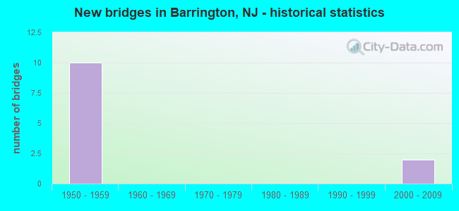
- New bridges - historical statistics
- 101950-1959
- 22000-2009

- Reconstructed bridges - Historical Statistics
- 22000-2009
- 22010-2019


- Bridge Condition - Deck
- 83.3%Good
- 16.7%Satisfactory

- Bridge Condition - Superstructure
- 33.3%Very good
- 50.0%Good
- 16.7%Satisfactory

- Bridge Condition - Substructure
- 16.7%Very good
- 33.3%Good
- 50.0%Satisfactory
Find on map >> Show street view
Structure Number: 428162, Location: 1.09 MI S OF I-295 EXT 30 (Lat: 39.874739, Lng: -75.057161), Route carried "on" structure: Interstate 295, Year Built: 1958, Year Reconstructed: 2011, Status: Open, Structure Length: 1.65m (5.41ft), Average Daily Traffic: 140,428 (year 2020), Truck Traffic: 9%, Average Future Daily Traffic: 171,348 (year 2040), Design Load: HS 20+Mod, Features Intersected: THIRD AVENUE (CR 653)
Minimum Vertical Clearance: 30+ m (98+ ft), Kilometerpoint: 47.572, Lanes on structure: 6, Lanes under structure: 2, Base Highway Network: Yes, Owner: State Highway Agency, Approaching Roadway Width: 32.3m (106.0ft), Skew: 30 degrees, Material/Design: Steel, Design/Construction: Stringer/Multi-beam, Number Of Spans In Main Unit: 1, Length of Maximum Span: 15.2m (49.9ft), Curb-To-Curb Width: 32.2m (105.6ft), Out-to-Out Width: 34.4m (112.9ft)
Condition: Deck: Good, Superstructure: Good, Substructure: Satisfactory, Operating Rating: 63.5 metric tons, Method Used To Determine Operating Rating: Load Factor (LF), Inventory Rating: 38.1 metric tons, Method Used To Determine Inventory Rating: Load Factor (LF), Structural Evaluation: Equal to present minimum criteria, Deck Geometry: Superior to present desirable criteria, Underclear: Better than present minimum criteria, Approach Roadway Alignment: Equal to present desirable criteria, Designated Inspection Frequency: Every 24 months, Inspection Date: May 2020, Deck Structure Type: Concrete Cast-file-Place, Wearing Surface/Protective System: Wearing Surface: Monolithic Concrete, Deck Protection: Epoxy Coated Reinforcing
Find on map >> Show street view
Structure Number: 428164, Location: AT I-295 EXIT 29 (Lat: 39.875000, Lng: -75.050000), Route carried "on" structure: Interstate 295, Year Built: 1958, Year Reconstructed: 2010, Status: Open, Structure Length: 2.01m (6.59ft), Average Daily Traffic: 141,020 (year 2021), Truck Traffic: 9%, Average Future Daily Traffic: 169,224 (year 2041), Design Load: HL 93, Features Intersected: CLEMENTS BRDG RD (NJ 41)
Minimum Vertical Clearance: 30+ m (98+ ft), Kilometerpoint: 48.200, Lanes on structure: 8, Lanes under structure: 2, Base Highway Network: Yes, Owner: State Highway Agency, Approaching Roadway Width: 32.0m (105.0ft), Skew: 31 degrees, Material/Design: Steel, Design/Construction: Stringer/Multi-beam, Number Of Spans In Main Unit: 1, Length of Maximum Span: 18.9m (62.0ft), Curb-To-Curb Width: 32.0m (105.0ft), Out-to-Out Width: 34.4m (112.9ft)
Condition: Deck: Good, Superstructure: Very good, Substructure: Good, Operating Rating: 96.9 metric tons, Method Used To Determine Operating Rating: Load and Resistance Factor Rating (LRFR) rating reported by rating factor(RF) method using HL-93 loadings, Inventory Rating: 96.9 metric tons, Method Used To Determine Inventory Rating: Load and Resistance Factor Rating (LRFR) rating reported by rating factor(RF) method using HL-93 loadings, Structural Evaluation: Better than present minimum criteria, Deck Geometry: Meets minimum limits, Underclear: Equal to present minimum criteria, Approach Roadway Alignment: Equal to present desirable criteria, Designated Inspection Frequency: Every 24 months, Inspection Date: July 2021, Deck Structure Type: Concrete Cast-file-Place, Wearing Surface/Protective System: Wearing Surface: Monolithic Concrete, Deck Protection: Epoxy Coated Reinforcing
Find on map >> Show street view
Structure Number: 428165, Location: AT I-295 EXIT 29 (Lat: 39.875111, Lng: -75.048419), Route carried "on" structure: Interstate 295, Year Built: 1958, Year Reconstructed: 2010, Status: Open, Structure Length: 3.38m (11.09ft), Average Daily Traffic: 147,339 (year 2019), Truck Traffic: 9%, Average Future Daily Traffic: 176,806 (year 2039), Design Load: HS 20+Mod, Features Intersected: US 30 (WHITE HORSE PIKE)
Minimum Vertical Clearance: 30+ m (98+ ft), Kilometerpoint: 48.280, Lanes on structure: 8, Lanes under structure: 4, Base Highway Network: Yes, Owner: State Highway Agency, Approaching Roadway Width: 31.7m (104.0ft), Skew: 34 degrees, Material/Design: Steel, Design/Construction: Stringer/Multi-beam, Number Of Spans In Main Unit: 1, Length of Maximum Span: 33.8m (110.9ft), Curb-To-Curb Width: 31.7m (104.0ft), Out-to-Out Width: 33.8m (110.9ft)
Condition: Deck: Good, Superstructure: Good, Substructure: Satisfactory, Operating Rating: 78.0 metric tons, Method Used To Determine Operating Rating: Load Factor (LF), Inventory Rating: 47.2 metric tons, Method Used To Determine Inventory Rating: Load Factor (LF), Structural Evaluation: Equal to present minimum criteria, Deck Geometry: Meets minimum limits, Underclear: Meets minimum limits, Approach Roadway Alignment: Equal to present desirable criteria, Designated Inspection Frequency: Every 24 months, Inspection Date: August 2021, Deck Structure Type: Concrete Cast-file-Place, Wearing Surface/Protective System: Wearing Surface: Monolithic Concrete, Deck Protection: Epoxy Coated Reinforcing
Find on map >> Show street view
Structure Number: 428166, Location: 4.58 MI SOUTH OF NJ 70 (Lat: 39.874539, Lng: -75.045081), Route carried "on" structure: Interstate 295, Year Built: 1958, Year Reconstructed: 2011, Status: Open, Structure Length: 2.19m (7.19ft), Average Daily Traffic: 122,269 (year 2020), Truck Traffic: 9%, Average Future Daily Traffic: 146,723 (year 2040), Design Load: HS 20+Mod, Features Intersected: COPLEY ROAD (CR666)
Minimum Vertical Clearance: 30+ m (98+ ft), Kilometerpoint: 48.634, Lanes on structure: 6, Lanes under structure: 3, Base Highway Network: Yes, Owner: State Highway Agency, Approaching Roadway Width: 37.8m (124.0ft), Skew: 32 degrees, Material/Design: Prestressed concrete, Design/Construction: Stringer/Multi-beam, Number Of Spans In Main Unit: 1, Length of Maximum Span: 20.7m (67.9ft), Curb-To-Curb Width: 37.8m (124.0ft), Out-to-Out Width: 40.1m (131.6ft)
Condition: Deck: Good, Superstructure: Good, Substructure: Good, Inventory Rating: 20.9 metric tons, Method Used To Determine Inventory Rating: Load Factor (LF), Structural Evaluation: Somewhat better than minimum adequacy, Deck Geometry: Superior to present desirable criteria, Underclear: Meets minimum limits, Approach Roadway Alignment: Equal to present desirable criteria, Designated Inspection Frequency: Every 24 months, Inspection Date: July 2020, Deck Structure Type: Concrete Cast-file-Place, Wearing Surface/Protective System: Wearing Surface: Monolithic Concrete, Deck Protection: Epoxy Coated Reinforcing
Find on map >> Show street view
Structure Number: M02698R, Location: 1 MI NORTH OF EXIT 3 (Lat: 39.863206, Lng: -75.056247), Route carried "on" structure: State highway 41, Year Built: 2005, Status: Open, Structure Length: 7.74m (25.39ft), Average Daily Traffic: 14,698 (year 2020), Truck Traffic: 4%, Average Future Daily Traffic: 17,933 (year 2040), Design Load: HL 93, Features Intersected: NJ TURNPIKE
Minimum Vertical Clearance: 30+ m (98+ ft), Kilometerpoint: 10.074, Lanes on structure: 2, Lanes under structure: 4, Owner: State Toll Authority, Approaching Roadway Width: 17.1m (56.1ft), Skew: 4 degrees, Material/Design: Steel continuous, Design/Construction: Stringer/Multi-beam, Number Of Spans In Main Unit: 2, Length of Maximum Span: 38.4m (126.0ft), Curb or Sidewalk Widths: Left: 1.8m (5.9ft), Right: 1.8m (5.9ft), Curb-To-Curb Width: 13.4m (44.0ft), Out-to-Out Width: 17.7m (58.1ft)
Condition: Deck: Good, Superstructure: Very good, Substructure: Very good, Operating Rating: 45.0 metric tons, Method Used To Determine Operating Rating: Load and Resistance Factor Rating (LRFR) rating reported by rating factor(RF) method using HL-93 loadings, Inventory Rating: 34.7 metric tons, Method Used To Determine Inventory Rating: Load and Resistance Factor Rating (LRFR) rating reported by rating factor(RF) method using HL-93 loadings, Structural Evaluation: Equal to present desirable criteria, Deck Geometry: Equal to present minimum criteria, Underclear: High priority of corrective action, Approach Roadway Alignment: Equal to present desirable criteria, Length Of Structure Improvement: 3.05m (10.01ft), Designated Inspection Frequency: Every 24 months, Inspection Date: Febuary 2020, Bridge Improvement Cost: $165,000, Roadway Improvement Cost: $35,000, Total Project Cost: $276,000 ( Estimate for 2018), Deck Structure Type: Concrete Cast-file-Place, Wearing Surface/Protective System: Wearing Surface: Monolithic Concrete, Deck Protection: Epoxy Coated Reinforcing
Find on map >> Show street view
Structure Number: M02728, Location: 1.2 MI NORTH OF EXIT 3 (Lat: 39.864058, Lng: -75.051197), Route carried "on" structure: City street , Year Built: 1950, Status: Open, Structure Length: 5.88m (19.29ft), Average Daily Traffic: 1,911 (year 2020), Truck Traffic: 3%, Average Future Daily Traffic: 2,308 (year 2040), Design Load: H 20, Features Intersected: TURNPIKE MAINLINE, Facility Carried by Structure: SHREVE AVE
Minimum Vertical Clearance: 30+ m (98+ ft), Kilometerpoint: 0.402, Lanes on structure: 2, Lanes under structure: 4, Owner: State Toll Authority, Approaching Roadway Width: 9.1m (29.9ft), Skew: 3 degrees, Material/Design: Steel continuous, Design/Construction: Stringer/Multi-beam, Number Of Spans In Main Unit: 4, Length of Maximum Span: 17.7m (58.1ft), Curb or Sidewalk Widths: Left: 1.2m (3.9ft), Right: 1.2m (3.9ft), Curb-To-Curb Width: 9.1m (29.9ft), Out-to-Out Width: 12.2m (40.0ft)
Condition: Deck: Satisfactory, Superstructure: Satisfactory, Substructure: Satisfactory, Operating Rating: 22.7 metric tons, Method Used To Determine Operating Rating: Load and Resistance Factor Rating (LRFR) rating reported by rating factor(RF) method using HL-93 loadings, Inventory Rating: 17.5 metric tons, Method Used To Determine Inventory Rating: Load and Resistance Factor Rating (LRFR) rating reported by rating factor(RF) method using HL-93 loadings, Structural Evaluation: Meets minimum limits, Deck Geometry: Somewhat better than minimum adequacy, Underclear: High priority of corrective action, Approach Roadway Alignment: Equal to present desirable criteria, Length Of Structure Improvement: 1.37m (4.49ft), Designated Inspection Frequency: Every 24 months, Inspection Date: March 2020, Bridge Improvement Cost: $33,000, Roadway Improvement Cost: $7,000, Total Project Cost: $56,000 ( Estimate for 2016), Deck Structure Type: Concrete Cast-file-Place
Find on map >> Show street view
Structure Number: 428162, Location: 1.09 MI S OF I-295 EXT 30 (Lat: 39.874739, Lng: -75.057161), Route carried "under" structure: County highway 653, Year Built: 1958, Structure Length: 0. m, Average Daily Traffic: 3,683 (year 2020), Truck Traffic: 3%, Features Intersected: THIRD AVENUE (CR 653), Facility Carried by Structure: I-295
Minimum Vertical Clearance: 4.82m (15.81ft), Kilometerpoint: 2.784, Lanes on structure: 6, Lanes under structure: 2, Material/Design: Steel, Design/Construction: Stringer/Multi-beam, Length of Maximum Span: 15.2m (49.9ft)
Find on map >> Show street view
Structure Number: 428164, Location: AT I-295 EXIT 29 (Lat: 39.875000, Lng: -75.050000), Route carried "under" structure: State highway 41, Year Built: 1958, Structure Length: 0. m, Average Daily Traffic: 14,820 (year 2021), Truck Traffic: 4%, Features Intersected: CLEMENTS BRDG RD (NJ 41), Facility Carried by Structure: I-295
Minimum Vertical Clearance: 6.58m (21.59ft), Kilometerpoint: 11.571, Lanes on structure: 8, Lanes under structure: 2, Material/Design: Steel, Design/Construction: Stringer/Multi-beam, Length of Maximum Span: 18.9m (62.0ft)
Find on map >> Show street view
Structure Number: 428165, Location: AT I-295 EXIT 29 (Lat: 39.875111, Lng: -75.048419), Route carried "under" structure: US 30, Year Built: 1958, Structure Length: 0. m, Average Daily Traffic: 32,023 (year 2019), Truck Traffic: 4%, Features Intersected: US 30 (WHITE HORSE PIKE), Facility Carried by Structure: I-295
Minimum Vertical Clearance: 4.52m (14.83ft), Kilometerpoint: 12.875, Lanes on structure: 8, Lanes under structure: 4, Material/Design: Steel, Design/Construction: Stringer/Multi-beam, Length of Maximum Span: 33.8m (110.9ft)
Find on map >> Show street view
Structure Number: 428166, Location: 4.58 MI SOUTH OF NJ 70 (Lat: 39.874539, Lng: -75.045081), Route carried "under" structure: County highway 666, Year Built: 1958, Structure Length: 0. m, Average Daily Traffic: 5,810 (year 2020), Truck Traffic: 1%, Features Intersected: COPLEY ROAD (CR666), Facility Carried by Structure: I-295
Minimum Vertical Clearance: 4.60m (15.09ft), Kilometerpoint: 0.193, Lanes on structure: 6, Lanes under structure: 3, Material/Design: Prestressed concrete, Design/Construction: Stringer/Multi-beam, Length of Maximum Span: 20.7m (67.9ft)
Find on map >> Show street view
Structure Number: M02698R, Location: 1 MI NORTH OF EXIT 3 (Lat: 39.863206, Lng: -75.056247), Route carried "under" structure: Other road NJTPK, Year Built: 2005, Structure Length: 0. m, Average Daily Traffic: 65,857 (year 2020), Truck Traffic: 5%, Features Intersected: NJ TURNPIKE, Facility Carried by Structure: NJ RT 41 (CR 573)
Minimum Vertical Clearance: 4.60m (15.09ft), Kilometerpoint: 43.806, Lanes on structure: 2, Lanes under structure: 4, Toll: On toll road, Material/Design: Steel continuous, Design/Construction: Stringer/Multi-beam, Length of Maximum Span: 38.4m (126.0ft)
Find on map >> Show street view
Structure Number: M02728, Location: 1.2 MI NORTH OF EXIT 3 (Lat: 39.864058, Lng: -75.051197), Route carried "under" structure: Other road NJTPK, Year Built: 1950, Structure Length: 0. m, Average Daily Traffic: 65,205 (year 2020), Truck Traffic: 11%, Features Intersected: TURNPIKE MAINLINE, Facility Carried by Structure: SHREVE AVE
Minimum Vertical Clearance: 4.62m (15.16ft), Kilometerpoint: 44.257, Lanes on structure: 2, Lanes under structure: 4, Toll: On toll road, Material/Design: Steel continuous, Design/Construction: Stringer/Multi-beam, Length of Maximum Span: 17.7m (58.1ft)