Bridge Statistics for Banning, California (CA)
Condition, Traffic, Stress, Structural Evaluation, Project Costs
- National Bridge Inventory (NBI) Statistics
- 26Number of bridges
- 138ft / 41.6mTotal length
- $1,229,000Total costs
- 1,013,892Total average daily traffic
- 152,196Total average daily truck traffic
- National Bridge Inventory (NBI) Registered Bridges for Banning
- No street view available for this location
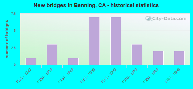
- New bridges - historical statistics
- 11920-1929
- 31930-1939
- 11940-1949
- 71950-1959
- 71960-1969
- 31970-1979
- 21980-1989
- 21990-1999

- Reconstructed bridges - Historical Statistics
- 11930-1939
- 11940-1949
- 11950-1959
- 41960-1969
- 21970-1979
- 01980-1989
- 01990-1999
- 12000-2009


- Bridge Condition - Deck
- 63.6%Good
- 36.4%Fair

- Bridge Condition - Superstructure
- 90.9%Good
- 9.1%Fair

- Bridge Condition - Substructure
- 90.9%Good
- 9.1%Fair

- Bridge Condition - Channel
- 20.0%Excellent
- 50.0%Very good
- 20.0%Good
- 10.0%Satisfactory

- Bridge Condition - Culverts
- 66.7%Good
- 33.3%Satisfactory
Find on map >> Show street view
Structure Number: 56 0003Z, Location: 08-RIV-010-R16.14-BAN (Lat: 33.931169, Lng: -116.828667), Route carried "on" structure: State highway 10, Year Built: 1925, Year Reconstructed: 1939, Status: Open, Structure Length: 7.28m (23.88ft), Average Daily Traffic: 2 (year 2012), Truck Traffic: 10%, Average Future Daily Traffic: 2 (year 2040), Design Load: H 15, Features Intersected: SAN GORGONIO WASH, Facility Carried by Structure: JOHNSON LANE
Minimum Vertical Clearance: 30+ m (98+ ft), Kilometerpoint: 16.140, Lanes on structure: 2, Owner: State Highway Agency, Approaching Roadway Width: 9.1m (29.9ft), Skew: 3 degrees, Material/Design: Concrete, Design/Construction: Tee Beam, Number Of Spans In Main Unit: 8, Length of Maximum Span: 9.2m (30.2ft), Curb or Sidewalk Widths: Left: 0.1m (0.3ft), Right: 0.1m (0.3ft), Curb-To-Curb Width: 9.1m (29.9ft), Out-to-Out Width: 10.1m (33.1ft)
Condition: Deck: Good, Superstructure: Good, Substructure: Fair, Channel: Very good, Operating Rating: 34.0 metric tons, Method Used To Determine Operating Rating: Load and Resistance Factor Rating (LRFR) rating reported by rating factor(RF) method using HL-93 loadings, Inventory Rating: 26.2 metric tons, Method Used To Determine Inventory Rating: Load and Resistance Factor Rating (LRFR) rating reported by rating factor(RF) method using HL-93 loadings, Structural Evaluation: Somewhat better than minimum adequacy, Deck Geometry: Better than present minimum criteria, Waterway Adequacy: Equal to present desirable criteria, Approach Roadway Alignment: Equal to present desirable criteria, Length Of Structure Improvement: 7.28m (23.88ft), Designated Inspection Frequency: Every 24 months, Inspection Date: November 2021, Bridge Improvement Cost: $732,000, Roadway Improvement Cost: $146,000, Total Project Cost: $1,229,000 ( Estimate for 2018), Deck Structure Type: Concrete Cast-file-Place, Wearing Surface/Protective System: Wearing Surface: Bituminous
Find on map >> Show street view
Structure Number: 56 0255, Location: 08-RIV-010-R15.79-BAN (Lat: 33.930433, Lng: -116.834833), Route carried "on" structure: Interstate 10, Year Built: 1935, Year Reconstructed: 1964, Status: Open, Structure Length: 1.07m (3.51ft), Average Daily Traffic: 120,000 (year 2014), Truck Traffic: 18%, Average Future Daily Traffic: 181,351 (year 2040), Design Load: HS 15, Features Intersected: ITTA WASH
Minimum Vertical Clearance: 30+ m (98+ ft), Kilometerpoint: 15.790, Lanes on structure: 10, Base Highway Network: Yes (, Subroute: 1), Owner: State Highway Agency, Approaching Roadway Width: 45.4m (149.0ft), Skew: 39 degrees, Material/Design: Concrete continuous, Design/Construction: Culvert, Number Of Spans In Main Unit: 4, Length of Maximum Span: 2.7m (8.9ft)
Condition: Channel: Good, Culverts: Good, Operating Rating: 27.2 metric tons, Method Used To Determine Operating Rating: Field evaluation and documented engineering judgment, Inventory Rating: 16.2 metric tons, Method Used To Determine Inventory Rating: Field evaluation and documented engineering judgment, Structural Evaluation: Meets minimum limits, Waterway Adequacy: Equal to present desirable criteria, Approach Roadway Alignment: Equal to present desirable criteria, Designated Inspection Frequency: Every 24 months, Inspection Date: November 2021
Find on map >> Show street view
Structure Number: 56 032, Location: 08-RIV-010-26.17 (Lat: 33.922075, Lng: -116.663192), Route carried "on" structure: Interstate 10, Year Built: 1952, Year Reconstructed: 1967, Status: Open, Structure Length: 0.67m (2.20ft), Average Daily Traffic: 79,000 (year 2012), Truck Traffic: 21%, Average Future Daily Traffic: 132,000 (year 2037), Features Intersected: STATION DRAIN
Minimum Vertical Clearance: 30+ m (98+ ft), Kilometerpoint: 26.170, Lanes on structure: 8, Base Highway Network: Yes (, Subroute: 1), Owner: State Highway Agency, Approaching Roadway Width: 20.1m (65.9ft), Skew: 30 degrees, Material/Design: Concrete continuous, Design/Construction: Culvert, Number Of Spans In Main Unit: 2, Length of Maximum Span: 3.0m (9.8ft)
Condition: Channel: Very good, Culverts: Good, Operating Rating: 54.1 metric tons, Method Used To Determine Operating Rating: Field evaluation and documented engineering judgment, Inventory Rating: 32.4 metric tons, Method Used To Determine Inventory Rating: Field evaluation and documented engineering judgment, Structural Evaluation: Better than present minimum criteria, Waterway Adequacy: Equal to present desirable criteria, Approach Roadway Alignment: Equal to present desirable criteria, Designated Inspection Frequency: Every 24 months, Inspection Date: October 2020
Find on map >> Show street view
Structure Number: 56 0323, Location: 08-RIV-010-12.85-BAN (Lat: 33.924056, Lng: -116.885561), Route carried "on" structure: Interstate 10, Year Built: 1956, Year Reconstructed: 1969, Status: Open, Structure Length: 1.92m (6.30ft), Average Daily Traffic: 120,000 (year 2012), Truck Traffic: 14%, Average Future Daily Traffic: 180,000 (year 2040), Design Load: HS 20, Features Intersected: STATE ROUTE 243 (8TH ST)
Minimum Vertical Clearance: 30+ m (98+ ft), Kilometerpoint: 12.850, Lanes on structure: 8, Lanes under structure: 2, Base Highway Network: Yes (, Subroute: 1), Owner: State Highway Agency, Approaching Roadway Width: 43.9m (144.0ft), Skew: 30 degrees, Material/Design: Concrete, Design/Construction: Box Beam or Girders - Multiple, Number Of Spans In Main Unit: 1, Length of Maximum Span: 18.9m (62.0ft), Curb-To-Curb Width: 43.9m (144.0ft), Out-to-Out Width: 44.5m (146.0ft)
Condition: Deck: Fair, Superstructure: Good, Substructure: Good, Operating Rating: 68.0 metric tons, Method Used To Determine Operating Rating: Load Factor (LF), Inventory Rating: 32.4 metric tons, Method Used To Determine Inventory Rating: Load Factor (LF), Structural Evaluation: Better than present minimum criteria, Deck Geometry: Superior to present desirable criteria, Underclear: High priority of corrective action, Approach Roadway Alignment: Equal to present desirable criteria, Designated Inspection Frequency: Every 24 months, Inspection Date: November 2021, Deck Structure Type: Concrete Cast-file-Place
Find on map >> Show street view
Structure Number: 56 0324, Location: 08-RIV-010-13.86-BAN (Lat: 33.924089, Lng: -116.868047), Route carried "on" structure: Interstate 10, Year Built: 1956, Year Reconstructed: 1969, Status: Open, Structure Length: 1.96m (6.43ft), Average Daily Traffic: 120,000 (year 2014), Truck Traffic: 18%, Average Future Daily Traffic: 181,351 (year 2039), Design Load: HS 20, Features Intersected: HARGRAVE STREET
Minimum Vertical Clearance: 30+ m (98+ ft), Kilometerpoint: 13.860, Lanes on structure: 8, Lanes under structure: 2, Base Highway Network: Yes (, Subroute: 1), Owner: State Highway Agency, Approaching Roadway Width: 43.3m (142.1ft), Skew: 30 degrees, Material/Design: Concrete, Design/Construction: Box Beam or Girders - Multiple, Number Of Spans In Main Unit: 1, Length of Maximum Span: 18.9m (62.0ft), Curb-To-Curb Width: 43.3m (142.1ft), Out-to-Out Width: 44.5m (146.0ft)
Condition: Deck: Fair, Superstructure: Fair, Substructure: Good, Operating Rating: 68.4 metric tons, Method Used To Determine Operating Rating: Load Factor (LF), Inventory Rating: 32.4 metric tons, Method Used To Determine Inventory Rating: Load Factor (LF), Structural Evaluation: Somewhat better than minimum adequacy, Deck Geometry: Superior to present desirable criteria, Underclear: Meets minimum limits, Approach Roadway Alignment: Equal to present desirable criteria, Designated Inspection Frequency: Every 24 months, Inspection Date: November 2021, Deck Structure Type: Concrete Cast-file-Place
Find on map >> Show street view
Structure Number: 56 0327, Location: 08-RIV-010-13.36-BAN (Lat: 33.924458, Lng: -116.876858), Route carried "on" structure: City street Y442, Year Built: 1969, Status: Open, Structure Length: 4.52m (14.83ft), Average Daily Traffic: 5,360 (year 2012), Truck Traffic: 2%, Average Future Daily Traffic: 8,396 (year 2040), Design Load: HS 20, Features Intersected: INTERSTATE 10, Facility Carried by Structure: SAN GORGONIO AVE
Minimum Vertical Clearance: 30+ m (98+ ft), Kilometerpoint: 0.000, Lanes on structure: 4, Lanes under structure: 8, Base Highway Network: Yes, Owner: State Highway Agency, Approaching Roadway Width: 19.5m (64.0ft), Material/Design: Prestressed concrete continuous, Design/Construction: Stringer/Multi-beam, Number Of Spans In Main Unit: 2, Length of Maximum Span: 22.6m (74.1ft), Curb or Sidewalk Widths: Left: 1.5m (4.9ft), Right: 1.5m (4.9ft), Curb-To-Curb Width: 19.5m (64.0ft), Out-to-Out Width: 23.2m (76.1ft)
Condition: Deck: Good, Superstructure: Good, Substructure: Good, Operating Rating: 31.1 metric tons, Method Used To Determine Operating Rating: Load and Resistance Factor Rating (LRFR) rating reported by rating factor(RF) method using HL-93 loadings, Inventory Rating: 21.1 metric tons, Method Used To Determine Inventory Rating: Load and Resistance Factor Rating (LRFR) rating reported by rating factor(RF) method using HL-93 loadings, Structural Evaluation: Somewhat better than minimum adequacy, Deck Geometry: Better than present minimum criteria, Underclear: Somewhat better than minimum adequacy, Approach Roadway Alignment: Equal to present desirable criteria, Designated Inspection Frequency: Every 24 months, Inspection Date: November 2021, Deck Structure Type: Concrete Cast-file-Place
Find on map >> Show street view
Structure Number: 56 0328, Location: 08-RIV-010-R14.76-BAN (Lat: 33.926450, Lng: -116.851839), Route carried "on" structure: Interstate 10, Year Built: 1956, Year Reconstructed: 1971, Status: Open, Structure Length: 5.81m (19.06ft), Average Daily Traffic: 111,000 (year 2012), Truck Traffic: 18%, Average Future Daily Traffic: 152,000 (year 2040), Design Load: HS 20, Features Intersected: E RAMSEY ST-E10 ON RAMP
Minimum Vertical Clearance: 30+ m (98+ ft), Kilometerpoint: 14.760, Lanes on structure: 8, Lanes under structure: 1, Base Highway Network: Yes (, Subroute: 1), Owner: State Highway Agency, Approaching Roadway Width: 30.8m (101.0ft), Skew: 35 degrees, Material/Design: Concrete, Design/Construction: Frame, Number Of Spans In Main Unit: 1, Length of Maximum Span: 20.0m (65.6ft), Curb-To-Curb Width: 30.8m (101.0ft), Out-to-Out Width: 32.0m (105.0ft)
Condition: Deck: Good, Superstructure: Good, Substructure: Good, Operating Rating: 48.3 metric tons, Method Used To Determine Operating Rating: Load Factor (LF), Inventory Rating: 29.2 metric tons, Method Used To Determine Inventory Rating: Load Factor (LF), Structural Evaluation: Better than present minimum criteria, Deck Geometry: High priority of corrective action, Underclear: Meets minimum limits, Approach Roadway Alignment: Equal to present desirable criteria, Designated Inspection Frequency: Every 24 months, Inspection Date: November 2021, Deck Structure Type: Concrete Cast-file-Place
Find on map >> Show street view
Structure Number: 56 0351Z, Location: 08-RIV-010-R16.23-BAN (Lat: 33.931158, Lng: -116.827183), Route carried "on" structure: State highway 10, Year Built: 1935, Status: Open, Structure Length: 1.16m (3.81ft), Average Daily Traffic: 10 (year 2012), Average Future Daily Traffic: 20 (year 2040), Design Load: H 20, Features Intersected: SAN GORGONIO OVERFLOW, Facility Carried by Structure: JOHNSON LANE
Minimum Vertical Clearance: 30+ m (98+ ft), Kilometerpoint: 16.230, Lanes on structure: 2, Owner: State Highway Agency, Approaching Roadway Width: 9.1m (29.9ft), Skew: 3 degrees, Material/Design: Wood or Timber, Design/Construction: Stringer/Multi-beam, Number Of Spans In Main Unit: 2, Length of Maximum Span: 5.8m (19.0ft), Curb or Sidewalk Widths: Left: 0.6m (2.0ft), Right: 0.6m (2.0ft), Curb-To-Curb Width: 9.1m (29.9ft), Out-to-Out Width: 10.1m (33.1ft)
Condition: Deck: Good, Superstructure: Good, Substructure: Good, Channel: Very good, Operating Rating: 27.5 metric tons, Method Used To Determine Operating Rating: Allowable Stress (AS), Inventory Rating: 18.1 metric tons, Method Used To Determine Inventory Rating: Allowable Stress (AS), Structural Evaluation: Somewhat better than minimum adequacy, Deck Geometry: Better than present minimum criteria, Waterway Adequacy: Better than present minimum criteria, Approach Roadway Alignment: Equal to present desirable criteria, Designated Inspection Frequency: Every 24 months, Inspection Date: November 2021, Deck Structure Type: Wood or Timber, Wearing Surface/Protective System: Wearing Surface: Bituminous
Find on map >> Show street view
Structure Number: 56 0431, Location: 08-RIV-010-11.33-BAN (Lat: 33.924389, Lng: -116.911914), Route carried "on" structure: Interstate 10, Year Built: 1961, Year Reconstructed: 1970, Status: Open, Structure Length: 2.49m (8.17ft), Average Daily Traffic: 123,000 (year 2012), Truck Traffic: 14%, Average Future Daily Traffic: 187,600 (year 2040), Design Load: HS 20, Features Intersected: SUNSET AVE
Minimum Vertical Clearance: 30+ m (98+ ft), Kilometerpoint: 11.330, Lanes on structure: 8, Lanes under structure: 2, Base Highway Network: Yes (, Subroute: 1), Owner: State Highway Agency, Approaching Roadway Width: 45.7m (149.9ft), Skew: 21 degrees, Material/Design: Concrete, Design/Construction: Box Beam or Girders - Multiple, Number Of Spans In Main Unit: 1, Length of Maximum Span: 24.9m (81.7ft), Curb-To-Curb Width: 45.7m (149.9ft), Out-to-Out Width: 47.1m (154.5ft)
Condition: Deck: Fair, Superstructure: Good, Substructure: Good, Operating Rating: 99.8 metric tons, Method Used To Determine Operating Rating: Load Factor (LF), Inventory Rating: 62.9 metric tons, Method Used To Determine Inventory Rating: Load Factor (LF), Structural Evaluation: Better than present minimum criteria, Deck Geometry: Superior to present desirable criteria, Underclear: Meets minimum limits, Approach Roadway Alignment: Equal to present desirable criteria, Designated Inspection Frequency: Every 24 months, Inspection Date: November 2021, Deck Structure Type: Concrete Cast-file-Place
Find on map >> Show street view
Structure Number: 56 0432, Location: 08-RIV-010-9.31-BAN (Lat: 33.926697, Lng: -116.947042), Route carried "on" structure: Interstate 10, Year Built: 1961, Year Reconstructed: 1970, Status: Open, Structure Length: 2.47m (8.10ft), Average Daily Traffic: 123,000 (year 2012), Truck Traffic: 14%, Average Future Daily Traffic: 187,600 (year 2040), Design Load: HS 20, Features Intersected: HIGHLAND SPRINGS AVE
Minimum Vertical Clearance: 30+ m (98+ ft), Kilometerpoint: 9.310, Lanes on structure: 8, Lanes under structure: 5, Base Highway Network: Yes (, Subroute: 1), Owner: State Highway Agency, Approaching Roadway Width: 45.7m (149.9ft), Skew: 30 degrees, Material/Design: Concrete, Design/Construction: Box Beam or Girders - Multiple, Number Of Spans In Main Unit: 1, Length of Maximum Span: 22.6m (74.1ft), Curb-To-Curb Width: 45.7m (149.9ft), Out-to-Out Width: 47.1m (154.5ft)
Condition: Deck: Fair, Superstructure: Good, Substructure: Good, Operating Rating: 70.0 metric tons, Method Used To Determine Operating Rating: Load and Resistance Factor Rating (LRFR) rating reported by rating factor(RF) method using HL-93 loadings, Inventory Rating: 49.6 metric tons, Method Used To Determine Inventory Rating: Load and Resistance Factor Rating (LRFR) rating reported by rating factor(RF) method using HL-93 loadings, Structural Evaluation: Better than present minimum criteria, Deck Geometry: Superior to present desirable criteria, Underclear: Meets minimum limits, Approach Roadway Alignment: Equal to present desirable criteria, Designated Inspection Frequency: Every 24 months, Inspection Date: November 2021, Deck Structure Type: Concrete Cast-file-Place
Find on map >> Show street view
Structure Number: 56 0712, Location: 08-RIV-243-28.16-BAN (Lat: 33.910058, Lng: -116.875539), Route carried "on" structure: State highway 243, Year Built: 1942, Status: Open, Structure Length: 2.10m (6.89ft), Average Daily Traffic: 2,000 (year 2012), Truck Traffic: 4%, Average Future Daily Traffic: 5,287 (year 2040), Design Load: H 15, Features Intersected: SMITH CREEK
Minimum Vertical Clearance: 30+ m (98+ ft), Kilometerpoint: 28.160, Lanes on structure: 2, Base Highway Network: Yes, Owner: State Highway Agency, Approaching Roadway Width: 7.3m (24.0ft), Material/Design: Concrete continuous, Design/Construction: Slab, Number Of Spans In Main Unit: 3, Length of Maximum Span: 10.9m (35.8ft), Curb-To-Curb Width: 7.3m (24.0ft), Out-to-Out Width: 8.5m (27.9ft)
Condition: Deck: Good, Superstructure: Good, Substructure: Good, Channel: Good, Operating Rating: 38.6 metric tons, Method Used To Determine Operating Rating: Load Factor (LF), Inventory Rating: 23.0 metric tons, Method Used To Determine Inventory Rating: Load Factor (LF), Structural Evaluation: Equal to present minimum criteria, Deck Geometry: Meets minimum limits, Waterway Adequacy: Equal to present desirable criteria, Approach Roadway Alignment: Equal to present desirable criteria, Designated Inspection Frequency: Every 24 months, Inspection Date: July 2021, Deck Structure Type: Concrete Cast-file-Place, Wearing Surface/Protective System: Wearing Surface: Bituminous
Find on map >> Show street view
Structure Number: 56 073, Location: 08-RIV-215-R31.08 (Lat: 33.843572, Lng: -117.251131), Route carried "on" structure: County highway W554, Year Built: 1984, Year Reconstructed: 2013, Status: Open, Structure Length: 6.07m (19.91ft), Average Daily Traffic: 11,700 (year 2012), Truck Traffic: 3%, Average Future Daily Traffic: 12,900 (year 2040), Design Load: HS 20, Features Intersected: INTERSTATE 215, Facility Carried by Structure: RAMONA EXPRESSWAY
Minimum Vertical Clearance: 6.25m (20.51ft), Kilometerpoint: 0.000, Lanes on structure: 5, Lanes under structure: 6, Owner: State Highway Agency, Approaching Roadway Width: 23.2m (76.1ft), Material/Design: Concrete continuous, Design/Construction: Box Beam or Girders - Multiple, Number Of Spans In Main Unit: 2, Length of Maximum Span: 31.7m (104.0ft), Curb or Sidewalk Widths: Left: 2.1m (6.9ft), Right: 0.0m, Curb-To-Curb Width: 34.1m (111.9ft), Out-to-Out Width: 37.0m (121.4ft)
Condition: Deck: Good, Superstructure: Good, Substructure: Good, Operating Rating: 54.1 metric tons, Method Used To Determine Operating Rating: Assigned rating based on Load Factor Design (LFD) reported in metric tons, Inventory Rating: 32.4 metric tons, Method Used To Determine Inventory Rating: Assigned rating based on Load Factor Design (LFD) reported in metric tons, Structural Evaluation: Better than present minimum criteria, Deck Geometry: Superior to present desirable criteria, Underclear: Somewhat better than minimum adequacy, Approach Roadway Alignment: Equal to present desirable criteria, Designated Inspection Frequency: Every 24 months, Inspection Date: April 2021, Deck Structure Type: Concrete Cast-file-Place
Find on map >> Show street view
Structure Number: 56 0752, Location: 08-RIV-243-29.23-BAN (Lat: 33.921731, Lng: -116.881175), Route carried "on" structure: State highway 243, Year Built: 1977, Status: Open, Structure Length: 0.67m (2.20ft), Average Daily Traffic: 3,700 (year 2011), Truck Traffic: 4%, Average Future Daily Traffic: 5,084 (year 2040), Design Load: HS 20, Features Intersected: GILMAN HOME CHANNEL
Minimum Vertical Clearance: 30+ m (98+ ft), Kilometerpoint: 29.230, Lanes on structure: 2, Base Highway Network: Yes (Inventory Route: 2, Subroute: 1), Owner: State Highway Agency, Approaching Roadway Width: 8.1m (26.6ft), Material/Design: Concrete, Design/Construction: Culvert, Number Of Spans In Main Unit: 1, Length of Maximum Span: 6.1m (20.0ft), Curb-To-Curb Width: 18.1m (59.4ft), Out-to-Out Width: 18.5m (60.7ft)
Condition: Channel: Very good, Culverts: Good, Operating Rating: 85.5 metric tons, Method Used To Determine Operating Rating: Load Factor (LF), Inventory Rating: 51.5 metric tons, Method Used To Determine Inventory Rating: Load Factor (LF), Structural Evaluation: Better than present minimum criteria, Deck Geometry: Superior to present desirable criteria, Waterway Adequacy: Equal to present desirable criteria, Approach Roadway Alignment: Equal to present desirable criteria, Designated Inspection Frequency: Every 48 months, Inspection Date: July 2021
Find on map >> Show street view
Structure Number: 56C0066, Location: 1.2 MI E/O HGHLND SPG AVE (Lat: 33.926756, Lng: -116.924589), Route carried "on" structure: City street , Year Built: 1935, Year Reconstructed: 1940, Status: Open, Structure Length: 0.79m (2.59ft), Average Daily Traffic: 25,000 (year 2014), Truck Traffic: 10%, Average Future Daily Traffic: 54,338 (year 2043), Features Intersected: SMITH CREEK, Facility Carried by Structure: RAMSEY STREET
Minimum Vertical Clearance: 30+ m (98+ ft), Kilometerpoint: 0.000, Lanes on structure: 4, Base Highway Network: Yes, Owner: City or Municipal Highway Agency, Approaching Roadway Width: 18.2m (59.7ft), Skew: 25 degrees, Material/Design: Concrete, Design/Construction: Culvert, Number Of Spans In Main Unit: 2, Length of Maximum Span: 3.1m (10.2ft), Curb-To-Curb Width: 18.2m (59.7ft), Out-to-Out Width: 29.2m (95.8ft)
Condition: Channel: Satisfactory, Culverts: Satisfactory, Operating Rating: 40.5 metric tons, Method Used To Determine Operating Rating: Field evaluation and documented engineering judgment, Inventory Rating: 24.3 metric tons, Method Used To Determine Inventory Rating: Field evaluation and documented engineering judgment, Structural Evaluation: Equal to present minimum criteria, Deck Geometry: Somewhat better than minimum adequacy, Waterway Adequacy: Better than present minimum criteria, Approach Roadway Alignment: Equal to present desirable criteria, Designated Inspection Frequency: Every 24 months, Inspection Date: September 2021
Find on map >> Show street view
Structure Number: 56C0305, Location: 0.64 MI. E/O HGHLND SPRGS (Lat: 33.932575, Lng: -116.935472), Route carried "on" structure: City street , Year Built: 1970, Status: Open, Structure Length: 0.79m (2.59ft), Average Daily Traffic: 14,000 (year 2014), Truck Traffic: 1%, Average Future Daily Traffic: 30,634 (year 2043), Design Load: H 15, Features Intersected: SMITH CREEK, Facility Carried by Structure: WILSON STREET
Minimum Vertical Clearance: 30+ m (98+ ft), Kilometerpoint: 0.000, Lanes on structure: 2, Base Highway Network: Yes, Owner: City or Municipal Highway Agency, Approaching Roadway Width: 12.2m (40.0ft), Skew: 2 degrees, Material/Design: Concrete, Design/Construction: Culvert, Number Of Spans In Main Unit: 2, Length of Maximum Span: 3.2m (10.5ft), Curb-To-Curb Width: 12.2m (40.0ft), Out-to-Out Width: 16.6m (54.5ft)
Condition: Channel: Very good, Culverts: Good, Operating Rating: 40.5 metric tons, Method Used To Determine Operating Rating: Field evaluation and documented engineering judgment, Inventory Rating: 24.3 metric tons, Method Used To Determine Inventory Rating: Field evaluation and documented engineering judgment, Structural Evaluation: Equal to present minimum criteria, Deck Geometry: Somewhat better than minimum adequacy, Waterway Adequacy: Equal to present desirable criteria, Approach Roadway Alignment: Equal to present desirable criteria, Designated Inspection Frequency: Every 24 months, Inspection Date: September 2021
Find on map >> Show street view
Structure Number: 56C0401, Location: 0.3 MI. E/O KITCHING ST. (Lat: 33.920881, Lng: -117.213403), Route carried "on" structure: City street , Year Built: 1987, Status: Open, Structure Length: 0.94m (3.08ft), Average Daily Traffic: 2,500 (year 2019), Truck Traffic: 1%, Average Future Daily Traffic: 4,190 (year 2037), Design Load: HS 20, Features Intersected: KITCHING CHANEL LINE 'Q', Facility Carried by Structure: BAY AVENUE
Minimum Vertical Clearance: 30+ m (98+ ft), Kilometerpoint: 0.000, Lanes on structure: 2, Owner: City or Municipal Highway Agency, Approaching Roadway Width: 13.3m (43.6ft), Material/Design: Concrete, Design/Construction: Slab, Number Of Spans In Main Unit: 1, Length of Maximum Span: 8.8m (28.9ft), Curb or Sidewalk Widths: Left: 1.5m (4.9ft), Right: 1.5m (4.9ft), Curb-To-Curb Width: 13.3m (43.6ft), Out-to-Out Width: 17.1m (56.1ft)
Condition: Deck: Good, Superstructure: Good, Substructure: Good, Channel: Excellent, Operating Rating: 54.1 metric tons, Method Used To Determine Operating Rating: Assigned rating based on Load Factor Design (LFD) reported in metric tons, Inventory Rating: 32.4 metric tons, Method Used To Determine Inventory Rating: Assigned rating based on Load Factor Design (LFD) reported in metric tons, Structural Evaluation: Better than present minimum criteria, Deck Geometry: Equal to present minimum criteria, Waterway Adequacy: Equal to present desirable criteria, Approach Roadway Alignment: Equal to present desirable criteria, Designated Inspection Frequency: Every 48 months, Inspection Date: July 2019, Deck Structure Type: Concrete Cast-file-Place
Find on map >> Show street view
Structure Number: 56C0445, Location: 200' N/O RAMSEY STREET (Lat: 33.927878, Lng: -116.929775), Route carried "on" structure: City street , Year Built: 1991, Status: Open, Structure Length: 0.91m (2.99ft), Average Daily Traffic: 3,000 (year 2014), Truck Traffic: 1%, Average Future Daily Traffic: 6,542 (year 2043), Features Intersected: SMITH CREEK, Facility Carried by Structure: HIGHLAND HOME ROAD
Minimum Vertical Clearance: 30+ m (98+ ft), Kilometerpoint: 0.000, Lanes on structure: 4, Base Highway Network: Yes, Owner: City or Municipal Highway Agency, Approaching Roadway Width: 19.6m (64.3ft), Material/Design: Concrete, Design/Construction: Culvert, Number Of Spans In Main Unit: 2, Length of Maximum Span: 4.3m (14.1ft), Curb or Sidewalk Widths: Left: 0.2m (0.7ft), Right: 0.2m (0.7ft), Curb-To-Curb Width: 19.6m (64.3ft), Out-to-Out Width: 39.0m (128.0ft)
Condition: Channel: Excellent, Culverts: Satisfactory, Operating Rating: 54.1 metric tons, Method Used To Determine Operating Rating: Field evaluation and documented engineering judgment, Inventory Rating: 32.4 metric tons, Method Used To Determine Inventory Rating: Field evaluation and documented engineering judgment, Structural Evaluation: Equal to present minimum criteria, Deck Geometry: Better than present minimum criteria, Waterway Adequacy: Equal to present desirable criteria, Approach Roadway Alignment: Equal to present desirable criteria, Designated Inspection Frequency: Every 48 months, Inspection Date: September 2021
Find on map >> Show street view
Structure Number: 56 0323, Location: 08-RIV-010-12.85-BAN (Lat: 33.924056, Lng: -116.885561), Route carried "under" structure: State highway 243, Year Built: 1956, Structure Length: 0. m, Average Daily Traffic: 7,000 (year 2014), Truck Traffic: 4%, Features Intersected: STATE ROUTE 243 (8TH ST), Facility Carried by Structure: INTERSTATE 10
Minimum Vertical Clearance: 4.85m (15.91ft), Kilometerpoint: 29.660, Lanes on structure: 8, Lanes under structure: 2, Material/Design: Concrete, Design/Construction: Box Beam or Girders - Multiple, Length of Maximum Span: 18.9m (62.0ft)
Find on map >> Show street view
Structure Number: 56 0324, Location: 08-RIV-010-13.86-BAN (Lat: 33.924089, Lng: -116.868047), Route carried "under" structure: City street Y443, Year Built: 1956, Structure Length: 0. m, Average Daily Traffic: 8,640 (year 2014), Truck Traffic: 2%, Features Intersected: HARGRAVE STREET, Facility Carried by Structure: INTERSTATE 10
Minimum Vertical Clearance: 4.27m (14.01ft), Kilometerpoint: 0.000, Lanes on structure: 8, Lanes under structure: 2, Material/Design: Concrete, Design/Construction: Box Beam or Girders - Multiple, Length of Maximum Span: 18.9m (62.0ft)
Find on map >> Show street view
Structure Number: 56 0327, Location: 08-RIV-010-13.36-BAN (Lat: 33.924458, Lng: -116.876858), Route carried "under" structure: Interstate 10, Year Built: 1969, Structure Length: 0. m, Average Daily Traffic: 86,000 (year 2012), Truck Traffic: 17%, Features Intersected: INTERSTATE 10, Facility Carried by Structure: SAN GORGONIO AVE
Minimum Vertical Clearance: 4.98m (16.34ft), Kilometerpoint: 13.360, Lanes on structure: 4, Lanes under structure: 8, Material/Design: Prestressed concrete continuous, Design/Construction: Stringer/Multi-beam, Length of Maximum Span: 22.6m (74.1ft)
Find on map >> Show street view
Structure Number: 56 0328, Location: 08-RIV-010-R14.76-BAN (Lat: 33.926450, Lng: -116.851839), Route carried "under" structure: Ramp Interstate 10, Year Built: 1956, Structure Length: 0. m, Average Daily Traffic: 1,100 (year 2012), Truck Traffic: 16%, Features Intersected: E RAMSEY ST-E10 ON RAMP
Minimum Vertical Clearance: 4.57m (14.99ft), Kilometerpoint: 14.760, Lanes on structure: 8, Lanes under structure: 1, Material/Design: Concrete, Design/Construction: Frame, Length of Maximum Span: 20.0m (65.6ft)
Find on map >> Show street view
Structure Number: 56 043, Location: 08-RIV-010-R11.96-BAN (Lat: 33.924097, Lng: -116.901139), Route carried "under" structure: City street Y439, Year Built: 1961, Structure Length: 0. m, Average Daily Traffic: 7,280 (year 2014), Truck Traffic: 2%, Features Intersected: 22ND STREET, Facility Carried by Structure: INTERSTATE 10
Minimum Vertical Clearance: 4.52m (14.83ft), Kilometerpoint: 0.000, Lanes on structure: 8, Lanes under structure: 2, Material/Design: Concrete, Design/Construction: Box Beam or Girders - Multiple, Length of Maximum Span: 24.5m (80.4ft)
Find on map >> Show street view
Structure Number: 56 0431, Location: 08-RIV-010-11.33-BAN (Lat: 33.924389, Lng: -116.911914), Route carried "under" structure: City street Y438, Year Built: 1961, Structure Length: 0. m, Average Daily Traffic: 700 (year 2014), Truck Traffic: 2%, Features Intersected: SUNSET AVE, Facility Carried by Structure: INTERSTATE 10
Minimum Vertical Clearance: 6.02m (19.75ft), Kilometerpoint: 0.000, Lanes on structure: 8, Lanes under structure: 2, Material/Design: Concrete, Design/Construction: Box Beam or Girders - Multiple, Length of Maximum Span: 24.9m (81.7ft)
Find on map >> Show street view
Structure Number: 56 0432, Location: 08-RIV-010-9.31-BAN (Lat: 33.926697, Lng: -116.947042), Route carried "under" structure: City street Y434, Year Built: 1961, Structure Length: 0. m, Average Daily Traffic: 4,300 (year 2014), Truck Traffic: 16%, Features Intersected: HIGHLAND SPRINGS AVE, Facility Carried by Structure: INTERSTATE 10
Minimum Vertical Clearance: 5.38m (17.65ft), Kilometerpoint: 0.000, Lanes on structure: 8, Lanes under structure: 5, Material/Design: Concrete, Design/Construction: Box Beam or Girders - Multiple, Length of Maximum Span: 22.6m (74.1ft)
Find on map >> Show street view
Structure Number: 56 0737, Location: 08-RIV-243-29.60-BAN (Lat: 33.923417, Lng: -116.885567), Route carried "under" structure: State highway 243, Year Built: 1976, Structure Length: 0. m, Average Daily Traffic: 7,000 (year 2011), Truck Traffic: 4%, Features Intersected: STATE ROUTE 243, Facility Carried by Structure: UP RR & AMTRAK
Minimum Vertical Clearance: 4.65m (15.26ft), Kilometerpoint: 29.600, Lanes under structure: 2, Material/Design: Prestressed concrete, Design/Construction: Box Beam or Girders - Multiple, Length of Maximum Span: 19.2m (63.0ft)
Find on map >> Show street view
Structure Number: 56C0406, Location: 0.1 MI SOUTH OF I10 (Lat: 33.925975, Lng: -116.947158), Route carried "under" structure: City street , Year Built: 1990, Structure Length: 0. m, Average Daily Traffic: 28,600 (year 2011), Truck Traffic: 5%, Features Intersected: UP RR & AMTRAK, Facility Carried by Structure: HIGHLAND SPRNGS AV
Minimum Vertical Clearance: 4.73m (15.52ft), Kilometerpoint: 0.000, Lanes under structure: 6, Material/Design: Prestressed concrete, Design/Construction: Box Beam or Girders - Multiple, Length of Maximum Span: 21.3m (69.9ft)