Bridge Statistics for Ballenger Creek, Maryland (MD)
Condition, Traffic, Stress, Structural Evaluation, Project Costs
- National Bridge Inventory (NBI) Statistics
- 39Number of bridges
- 384ft / 117mTotal length
- $1,064,000Total costs
- 1,283,155Total average daily traffic
- 87,909Total average daily truck traffic
- National Bridge Inventory (NBI) Registered Bridges for Ballenger Creek
- No street view available for this location
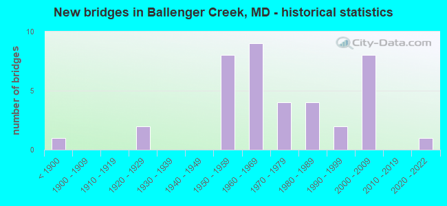
- New bridges - historical statistics
- 1Before 1900
- 21920-1929
- 81950-1959
- 91960-1969
- 41970-1979
- 41980-1989
- 21990-1999
- 82000-2009
- 12020-2022

- Reconstructed bridges - Historical Statistics
- 11930-1939
- 01940-1949
- 21950-1959
- 01960-1969
- 51970-1979


- Bridge Condition - Deck
- 5.9%Very good
- 35.3%Good
- 41.2%Satisfactory
- 17.6%Fair

- Bridge Condition - Superstructure
- 11.8%Very good
- 35.3%Good
- 35.3%Satisfactory
- 17.6%Fair

- Bridge Condition - Substructure
- 5.9%Very good
- 29.4%Good
- 58.8%Satisfactory
- 5.9%Fair

- Bridge Condition - Channel
- 6.3%Very good
- 37.5%Good
- 43.8%Satisfactory
- 12.5%Fair

- Bridge Condition - Culverts
- 22.2%Very good
- 44.4%Good
- 33.3%Satisfactory
Find on map >> Show street view
Structure Number: 10000010001201, Location: 1.3 MILES SOUTH OF IS 270 (Lat: 39.364589, Lng: -77.416764), Route carried "on" structure: State highway 85, Year Built: 1926, Year Reconstructed: 1950, Status: Open, Structure Length: 1.83m (6.00ft), Average Daily Traffic: 17,450 (year 2018), Truck Traffic: 8%, Average Future Daily Traffic: 17,555 (year 2038), Design Load: H 20, Features Intersected: BALLENGER CREEK
Minimum Vertical Clearance: 30+ m (98+ ft), Kilometerpoint: 12.486, Lanes on structure: 2, Base Highway Network: Yes, Owner: State Highway Agency, Approaching Roadway Width: 11.6m (38.1ft), Material/Design: Concrete, Design/Construction: Arch - Deck, Number Of Spans In Main Unit: 1, Length of Maximum Span: 18.3m (60.0ft), Curb or Sidewalk Widths: Left: 0.9m (3.0ft), Right: 0.9m (3.0ft), Curb-To-Curb Width: 9.1m (29.9ft), Out-to-Out Width: 11.8m (38.7ft)
Condition: Deck: Satisfactory, Superstructure: Satisfactory, Substructure: Satisfactory, Channel: Good, Operating Rating: 77.1 metric tons, Method Used To Determine Operating Rating: Load Factor (LF), Inventory Rating: 46.3 metric tons, Method Used To Determine Inventory Rating: Load Factor (LF), Structural Evaluation: Equal to present minimum criteria, Deck Geometry: High priority of corrective action, Waterway Adequacy: Better than present minimum criteria, Approach Roadway Alignment: Equal to present desirable criteria, Length Of Structure Improvement: 1.89m (6.20ft), Designated Inspection Frequency: Every 24 months, Inspection Date: May 2021, Bridge Improvement Cost: $144,000, Roadway Improvement Cost: $14,000, Total Project Cost: $158,000, Deck Structure Type: Concrete Cast-file-Place, Wearing Surface/Protective System: Wearing Surface: Bituminous
Find on map >> Show street view
Structure Number: 10000010007301, Location: 1.0 N OF BR NO 1007400 (Lat: 39.381867, Lng: -77.409764), Route carried "on" structure: Interstate 270, Year Built: 2020, Status: Open, Structure Length: 13.17m (43.21ft), Average Daily Traffic: 111,550 (year 2010), Truck Traffic: 11%, Average Future Daily Traffic: 161,800 (year 2030), Features Intersected: MD 85 (Buckeystown Pike)
Minimum Vertical Clearance: 30+ m (98+ ft), Kilometerpoint: 13.900, Lanes on structure: 5, Lanes under structure: 8, Owner: State Highway Agency, Approaching Roadway Width: 34.7m (113.8ft), Skew: 35 degrees, Material/Design: Steel, Design/Construction: Stringer/Multi-beam, Number Of Spans In Main Unit: 3, Length of Maximum Span: 45.7m (149.9ft), Curb-To-Curb Width: 34.7m (113.8ft), Out-to-Out Width: 36.0m (118.1ft)
Condition: Deck: Very good, Superstructure: Very good, Substructure: Very good, Operating Rating: 56.4 metric tons, Method Used To Determine Operating Rating: Load and Resistance Factor Rating (LRFR) rating reported by rating factor(RF) method using HL-93 loadings, Inventory Rating: 43.7 metric tons, Method Used To Determine Inventory Rating: Load and Resistance Factor Rating (LRFR) rating reported by rating factor(RF) method using HL-93 loadings, Structural Evaluation: Equal to present desirable criteria, Deck Geometry: Superior to present desirable criteria, Underclear: Superior to present desirable criteria, Approach Roadway Alignment: Equal to present desirable criteria, Length Of Structure Improvement: 3.23m (10.60ft), Designated Inspection Frequency: Every 24 months, Inspection Date: January 2022, Bridge Improvement Cost: $238,000, Roadway Improvement Cost: $24,000, Total Project Cost: $262,000, Deck Structure Type: Concrete Cast-file-Place, Wearing Surface/Protective System: Wearing Surface: Monolithic Concrete, Deck Protection: Epoxy Coated Reinforcing
Find on map >> Show street view
Structure Number: 10000010007401, Location: 1.0 MILE SOUTH OF MD 85 (Lat: 39.368764, Lng: -77.402164), Route carried "on" structure: Interstate 270, Year Built: 1950, Year Reconstructed: 1983, Status: Open, Structure Length: 4.21m (13.81ft), Average Daily Traffic: 80,340 (year 2009), Truck Traffic: 8%, Average Future Daily Traffic: 110,800 (year 2029), Design Load: HS 20, Features Intersected: CSX TRANSPORTATION
Minimum Vertical Clearance: 30+ m (98+ ft), Kilometerpoint: 12.309, Lanes on structure: 4, Base Highway Network: Yes, Owner: State Highway Agency, Approaching Roadway Width: 27.7m (90.9ft), Skew: 20 degrees, Material/Design: Steel, Design/Construction: Stringer/Multi-beam, Number Of Spans In Main Unit: 3, Length of Maximum Span: 16.8m (55.1ft), Curb-To-Curb Width: 27.4m (89.9ft), Out-to-Out Width: 28.4m (93.2ft)
Condition: Deck: Satisfactory, Superstructure: Satisfactory, Substructure: Satisfactory, Operating Rating: 57.1 metric tons, Method Used To Determine Operating Rating: Load Factor (LF), Inventory Rating: 34.0 metric tons, Method Used To Determine Inventory Rating: Load Factor (LF), Structural Evaluation: Equal to present minimum criteria, Deck Geometry: Superior to present desirable criteria, Underclear: Somewhat better than minimum adequacy, Approach Roadway Alignment: Equal to present desirable criteria, Designated Inspection Frequency: Every 24 months, Inspection Date: June 2021, Deck Structure Type: Concrete Cast-file-Place, Wearing Surface/Protective System: Wearing Surface: Monolithic Concrete
Find on map >> Show street view
Structure Number: 10000010007501, Location: 1.32 MILE SOUTH OF MD 85 (Lat: 39.364131, Lng: -77.399517), Route carried "on" structure: Interstate 270, Year Built: 1950, Year Reconstructed: 1983, Status: Open, Structure Length: 15.45m (50.69ft), Average Daily Traffic: 80,340 (year 2009), Truck Traffic: 8%, Average Future Daily Traffic: 83,959 (year 2026), Design Load: HS 20, Features Intersected: MONOCACY RIVER
Minimum Vertical Clearance: 30+ m (98+ ft), Kilometerpoint: 11.794, Lanes on structure: 4, Base Highway Network: Yes, Owner: State Highway Agency, Approaching Roadway Width: 27.7m (90.9ft), Skew: 20 degrees, Material/Design: Steel continuous, Design/Construction: Stringer/Multi-beam, Number Of Spans In Main Unit: 3, Number Of Approach Spans: 2, Length of Maximum Span: 42.7m (140.1ft), Curb-To-Curb Width: 27.4m (89.9ft), Out-to-Out Width: 28.4m (93.2ft)
Condition: Deck: Satisfactory, Superstructure: Satisfactory, Substructure: Satisfactory, Channel: Satisfactory, Operating Rating: 76.2 metric tons, Method Used To Determine Operating Rating: Load Factor (LF), Inventory Rating: 45.8 metric tons, Method Used To Determine Inventory Rating: Load Factor (LF), Structural Evaluation: Equal to present minimum criteria, Deck Geometry: Superior to present desirable criteria, Waterway Adequacy: Equal to present desirable criteria, Approach Roadway Alignment: Equal to present desirable criteria, Designated Inspection Frequency: Every 24 months, Underwater Inspection Frequency: Every 48 months, Inspection Date: Febuary 2021, Underwater Inspection Date: August 2021, Deck Structure Type: Concrete Cast-file-Place, Wearing Surface/Protective System: Wearing Surface: Monolithic Concrete
Find on map >> Show street view
Structure Number: 100000100076011, Location: 2.96 MILES NORTH OF MD 80 (Lat: 39.353236, Lng: -77.393494), Route carried "on" structure: Interstate 270, Year Built: 1950, Year Reconstructed: 1975, Status: Open, Structure Length: 1.80m (5.91ft), Average Daily Traffic: 80,340 (year 2009), Truck Traffic: 8%, Average Future Daily Traffic: 110,800 (year 2029), Design Load: HS 20, Features Intersected: BAKER VALLEY RD
Minimum Vertical Clearance: 30+ m (98+ ft), Kilometerpoint: 10.413, Lanes on structure: 2, Lanes under structure: 2, Base Highway Network: Yes, Owner: State Highway Agency, Approaching Roadway Width: 11.6m (38.1ft), Skew: 4 degrees, Material/Design: Steel, Design/Construction: Stringer/Multi-beam, Number Of Spans In Main Unit: 1, Length of Maximum Span: 16.8m (55.1ft), Curb-To-Curb Width: 11.3m (37.1ft), Out-to-Out Width: 13.1m (43.0ft)
Condition: Deck: Satisfactory, Superstructure: Good, Substructure: Satisfactory, Operating Rating: 79.8 metric tons, Method Used To Determine Operating Rating: Load Factor (LF), Inventory Rating: 47.6 metric tons, Method Used To Determine Inventory Rating: Load Factor (LF), Structural Evaluation: Equal to present minimum criteria, Deck Geometry: Somewhat better than minimum adequacy, Underclear: Meets minimum limits, Approach Roadway Alignment: Equal to present desirable criteria, Length Of Structure Improvement: 1.80m (5.91ft), Designated Inspection Frequency: Every 24 months, Inspection Date: August 2020, Bridge Improvement Cost: $152,000, Roadway Improvement Cost: $15,000, Total Project Cost: $167,000, Deck Structure Type: Concrete Cast-file-Place, Wearing Surface/Protective System: Wearing Surface: Bituminous
Find on map >> Show street view
Structure Number: 100000100076012, Location: 2.96 MILES NORTH OF MD 80 (Lat: 39.353142, Lng: -77.393742), Route carried "on" structure: Interstate 270, Year Built: 1950, Year Reconstructed: 1975, Status: Open, Structure Length: 1.80m (5.91ft), Average Daily Traffic: 80,340 (year 2009), Truck Traffic: 8%, Average Future Daily Traffic: 110,800 (year 2029), Design Load: HS 20, Features Intersected: BAKER VALLEY RD
Minimum Vertical Clearance: 30+ m (98+ ft), Kilometerpoint: 10.413, Lanes on structure: 2, Lanes under structure: 2, Base Highway Network: Yes, Owner: State Highway Agency, Approaching Roadway Width: 11.6m (38.1ft), Skew: 4 degrees, Material/Design: Steel, Design/Construction: Stringer/Multi-beam, Number Of Spans In Main Unit: 1, Length of Maximum Span: 16.8m (55.1ft), Curb-To-Curb Width: 11.3m (37.1ft), Out-to-Out Width: 13.1m (43.0ft)
Condition: Deck: Satisfactory, Superstructure: Satisfactory, Substructure: Satisfactory, Operating Rating: 79.8 metric tons, Method Used To Determine Operating Rating: Load Factor (LF), Inventory Rating: 47.6 metric tons, Method Used To Determine Inventory Rating: Load Factor (LF), Structural Evaluation: Equal to present minimum criteria, Deck Geometry: Somewhat better than minimum adequacy, Underclear: Meets minimum limits, Approach Roadway Alignment: Equal to present desirable criteria, Length Of Structure Improvement: 1.80m (5.91ft), Designated Inspection Frequency: Every 24 months, Inspection Date: August 2020, Bridge Improvement Cost: $152,000, Roadway Improvement Cost: $15,000, Total Project Cost: $167,000, Deck Structure Type: Concrete Cast-file-Place, Wearing Surface/Protective System: Wearing Surface: Bituminous
Find on map >> Show street view
Structure Number: 10000010008301, Location: 1.74 MILES WEST OF IS 70 (Lat: 39.387483, Lng: -77.473122), Route carried "on" structure: State highway 180, Year Built: 1925, Year Reconstructed: 1958, Status: Open, Structure Length: 0.94m (3.08ft), Average Daily Traffic: 3,850 (year 2009), Truck Traffic: 8%, Average Future Daily Traffic: 4,635 (year 2026), Design Load: HS 20, Features Intersected: BALLENGER CREEK
Minimum Vertical Clearance: 30+ m (98+ ft), Kilometerpoint: 19.726, Lanes on structure: 2, Owner: State Highway Agency, Approaching Roadway Width: 11.6m (38.1ft), Material/Design: Concrete, Design/Construction: Slab, Number Of Spans In Main Unit: 2, Length of Maximum Span: 4.3m (14.1ft), Curb-To-Curb Width: 12.2m (40.0ft), Out-to-Out Width: 12.8m (42.0ft)
Condition: Deck: Fair, Superstructure: Fair, Substructure: Satisfactory, Channel: Fair, Operating Rating: 51.2 metric tons, Method Used To Determine Operating Rating: Load Factor (LF), Inventory Rating: 30.8 metric tons, Method Used To Determine Inventory Rating: Load Factor (LF), Structural Evaluation: Somewhat better than minimum adequacy, Deck Geometry: Equal to present minimum criteria, Waterway Adequacy: Somewhat better than minimum adequacy, Approach Roadway Alignment: Equal to present desirable criteria, Designated Inspection Frequency: Every 24 months, Inspection Date: September 2021, Deck Structure Type: Concrete Cast-file-Place, Wearing Surface/Protective System: Wearing Surface: Bituminous
Find on map >> Show street view
Structure Number: 10000010010401, Location: 0.51 MI W OF MD 355 (Lat: 39.397503, Lng: -77.418608), Route carried "on" structure: County highway 324, Year Built: 2002, Status: Open, Structure Length: 10.18m (33.40ft), Average Daily Traffic: 15,170 (year 2009), Truck Traffic: 5%, Average Future Daily Traffic: 27,150 (year 2029), Design Load: HS 25 or greater, Features Intersected: IS 70, Facility Carried by Structure: NEW DESIGN ROAD
Minimum Vertical Clearance: 30+ m (98+ ft), Kilometerpoint: 16.766, Lanes on structure: 4, Lanes under structure: 10, Owner: State Highway Agency, Approaching Roadway Width: 18.9m (62.0ft), Skew: 22 degrees, Material/Design: Steel continuous, Design/Construction: Stringer/Multi-beam, Number Of Spans In Main Unit: 2, Length of Maximum Span: 53.3m (174.9ft), Curb or Sidewalk Widths: Left: 1.6m (5.2ft), Right: 0.0m, Curb-To-Curb Width: 17.7m (58.1ft), Out-to-Out Width: 21.5m (70.5ft)
Condition: Deck: Good, Superstructure: Good, Substructure: Good, Inventory Rating: 59.0 metric tons, Method Used To Determine Inventory Rating: Load Factor (LF), Structural Evaluation: Better than present minimum criteria, Deck Geometry: Somewhat better than minimum adequacy, Underclear: Meets minimum limits, Approach Roadway Alignment: Equal to present desirable criteria, Designated Inspection Frequency: Every 24 months, Inspection Date: July 2021, Deck Structure Type: Concrete Cast-file-Place, Wearing Surface/Protective System: Wearing Surface: Integral Concrete, Deck Protection: Epoxy Coated Reinforcing
Find on map >> Show street view
Structure Number: 10000010010501, Location: 0.1 MILE NORTH OF MD 85 (Lat: 39.399647, Lng: -77.409239), Route carried "on" structure: State highway 355, Year Built: 2008, Status: Open, Structure Length: 6.86m (22.51ft), Average Daily Traffic: 19,242 (year 2009), Truck Traffic: 8%, Average Future Daily Traffic: 20,015 (year 2026), Design Load: HS 25 or greater, Features Intersected: IS 70
Minimum Vertical Clearance: 30+ m (98+ ft), Kilometerpoint: 15.993, Lanes on structure: 6, Lanes under structure: 9, Owner: State Highway Agency, Approaching Roadway Width: 28.7m (94.2ft), Skew: 20 degrees, Material/Design: Steel, Design/Construction: Stringer/Multi-beam, Number Of Spans In Main Unit: 2, Length of Maximum Span: 35.1m (115.2ft), Curb or Sidewalk Widths: Left: 1.6m (5.2ft), Right: 1.6m (5.2ft), Curb-To-Curb Width: 28.7m (94.2ft), Out-to-Out Width: 32.6m (107.0ft)
Condition: Deck: Good, Superstructure: Very good, Substructure: Good, Inventory Rating: 54.4 metric tons, Method Used To Determine Inventory Rating: Load Factor (LF), Structural Evaluation: Better than present minimum criteria, Deck Geometry: Superior to present desirable criteria, Underclear: Equal to present minimum criteria, Approach Roadway Alignment: Equal to present desirable criteria, Designated Inspection Frequency: Every 24 months, Inspection Date: March 2020, Deck Structure Type: Concrete Cast-file-Place, Wearing Surface/Protective System: Wearing Surface: Integral Concrete, Deck Protection: Epoxy Coated Reinforcing
Find on map >> Show street view
Structure Number: 10000010010701, Location: 0.38 M W OF KING AVENUE (Lat: 39.403981, Lng: -77.383750), Route carried "on" structure: State highway 144FA, Year Built: 1984, Status: Open, Structure Length: 8.93m (29.30ft), Average Daily Traffic: 11,771 (year 2018), Truck Traffic: 8%, Average Future Daily Traffic: 11,842 (year 2038), Design Load: HS 20, Features Intersected: IS 70
Minimum Vertical Clearance: 30+ m (98+ ft), Kilometerpoint: 5.374, Lanes on structure: 2, Lanes under structure: 6, Base Highway Network: Yes, Owner: State Highway Agency, Approaching Roadway Width: 13.4m (44.0ft), Skew: 3 degrees, Material/Design: Steel continuous, Design/Construction: Stringer/Multi-beam, Number Of Spans In Main Unit: 2, Length of Maximum Span: 46.3m (151.9ft), Curb-To-Curb Width: 13.4m (44.0ft), Out-to-Out Width: 14.4m (47.2ft)
Condition: Deck: Good, Superstructure: Good, Substructure: Satisfactory, Inventory Rating: 55.3 metric tons, Method Used To Determine Inventory Rating: Load Factor (LF), Structural Evaluation: Equal to present minimum criteria, Deck Geometry: Equal to present minimum criteria, Underclear: Somewhat better than minimum adequacy, Approach Roadway Alignment: Equal to present desirable criteria, Designated Inspection Frequency: Every 24 months, Inspection Date: April 2020, Deck Structure Type: Concrete Cast-file-Place, Wearing Surface/Protective System: Wearing Surface: Monolithic Concrete, Deck Protection: Epoxy Coated Reinforcing
Find on map >> Show street view
Structure Number: 10000010011001, Location: 1.03 MI N OF MD 85 (Lat: 39.393636, Lng: -77.420844), Route carried "on" structure: County highway 324, Year Built: 2001, Status: Open, Structure Length: 8.84m (29.00ft), Average Daily Traffic: 16,080 (year 2019), Truck Traffic: 5%, Average Future Daily Traffic: 28,779 (year 2039), Design Load: HS 25 or greater, Features Intersected: IS 270, Facility Carried by Structure: NEW DESIGN ROAD
Minimum Vertical Clearance: 30+ m (98+ ft), Kilometerpoint: 16.299, Lanes on structure: 4, Lanes under structure: 9, Owner: State Highway Agency, Approaching Roadway Width: 8.5m (27.9ft), Skew: 23 degrees, Material/Design: Steel continuous, Design/Construction: Stringer/Multi-beam, Number Of Spans In Main Unit: 2, Length of Maximum Span: 45.7m (149.9ft), Curb or Sidewalk Widths: Left: 1.6m (5.2ft), Right: 0.0m, Curb-To-Curb Width: 17.7m (58.1ft), Out-to-Out Width: 21.4m (70.2ft)
Condition: Deck: Good, Superstructure: Good, Substructure: Good, Operating Rating: 86.2 metric tons, Method Used To Determine Operating Rating: Load Factor (LF), Inventory Rating: 51.7 metric tons, Method Used To Determine Inventory Rating: Load Factor (LF), Structural Evaluation: Better than present minimum criteria, Deck Geometry: Somewhat better than minimum adequacy, Underclear: Superior to present desirable criteria, Approach Roadway Alignment: Equal to present desirable criteria, Designated Inspection Frequency: Every 24 months, Inspection Date: December 2021, Deck Structure Type: Concrete Cast-file-Place, Wearing Surface/Protective System: Wearing Surface: Integral Concrete, Deck Protection: Epoxy Coated Reinforcing
Find on map >> Show street view
Structure Number: 100000100141014, Location: 0.37 MILE EAST OF MD 180 (Lat: 39.399244, Lng: -77.440278), Route carried "on" structure: Interstate 70, Year Built: 1968, Status: Open, Structure Length: 6.10m (20.01ft), Average Daily Traffic: 89,580 (year 2016), Truck Traffic: 8%, Average Future Daily Traffic: 114,844 (year 2036), Features Intersected: US 15
Minimum Vertical Clearance: 30+ m (98+ ft), Kilometerpoint: 22.108, Lanes on structure: 2, Lanes under structure: 5, Base Highway Network: Yes, Owner: State Highway Agency, Approaching Roadway Width: 11.6m (38.1ft), Skew: 1 degrees, Material/Design: Steel continuous, Design/Construction: Stringer/Multi-beam, Number Of Spans In Main Unit: 2, Length of Maximum Span: 29.9m (98.1ft), Curb-To-Curb Width: 11.7m (38.4ft), Out-to-Out Width: 12.8m (42.0ft)
Condition: Deck: Satisfactory, Superstructure: Satisfactory, Substructure: Satisfactory, Inventory Rating: 55.3 metric tons, Method Used To Determine Inventory Rating: Load Factor (LF), Structural Evaluation: Equal to present minimum criteria, Deck Geometry: Equal to present minimum criteria, Underclear: Meets minimum limits, Approach Roadway Alignment: Equal to present desirable criteria, Designated Inspection Frequency: Every 24 months, Inspection Date: May 2020, Deck Structure Type: Concrete Cast-file-Place, Wearing Surface/Protective System: Wearing Surface: Monolithic Concrete
Find on map >> Show street view
Structure Number: 10000010014401, Location: 0.49 MILE WEST OF US 15 (Lat: 39.401708, Lng: -77.447058), Route carried "on" structure: State highway 180, Year Built: 1968, Year Reconstructed: 1976, Status: Open, Structure Length: 8.41m (27.59ft), Average Daily Traffic: 3,850 (year 2009), Truck Traffic: 8%, Average Future Daily Traffic: 4,635 (year 2026), Design Load: HS 20+Mod, Features Intersected: IS 70
Minimum Vertical Clearance: 30+ m (98+ ft), Kilometerpoint: 22.526, Lanes on structure: 2, Lanes under structure: 6, Owner: State Highway Agency, Approaching Roadway Width: 9.8m (32.2ft), Skew: 4 degrees, Material/Design: Steel continuous, Design/Construction: Stringer/Multi-beam, Number Of Spans In Main Unit: 2, Length of Maximum Span: 41.1m (134.8ft), Curb or Sidewalk Widths: Left: 1.6m (5.2ft), Right: 0.0m, Curb-To-Curb Width: 9.3m (30.5ft), Out-to-Out Width: 11.9m (39.0ft)
Condition: Deck: Satisfactory, Superstructure: Satisfactory, Substructure: Satisfactory, Operating Rating: 88.0 metric tons, Method Used To Determine Operating Rating: Load Factor (LF), Inventory Rating: 52.6 metric tons, Method Used To Determine Inventory Rating: Load Factor (LF), Structural Evaluation: Equal to present minimum criteria, Deck Geometry: Meets minimum limits, Underclear: Somewhat better than minimum adequacy, Approach Roadway Alignment: Equal to present desirable criteria, Designated Inspection Frequency: Every 24 months, Inspection Date: March 2021, Deck Structure Type: Concrete Cast-file-Place, Wearing Surface/Protective System: Wearing Surface: Monolithic Concrete
Find on map >> Show street view
Structure Number: 10000010015102, Location: 1.95 MILES SOUTH OF IS 70 (Lat: 39.380897, Lng: -77.467533), Route carried "on" structure: US 15, Year Built: 1968, Status: Open, Structure Length: 0.88m (2.89ft), Average Daily Traffic: 53,991 (year 2013), Truck Traffic: 8%, Average Future Daily Traffic: 79,130 (year 2029), Design Load: HS 20, Features Intersected: BALLENGER CREEK
Minimum Vertical Clearance: 30+ m (98+ ft), Kilometerpoint: 15.044, Lanes on structure: 4, Base Highway Network: Yes, Owner: State Highway Agency, Approaching Roadway Width: 43.3m (142.1ft), Material/Design: Concrete, Design/Construction: Culvert, Length of Maximum Span: 4.3m (14.1ft)
Condition: Channel: Satisfactory, Culverts: Satisfactory, Operating Rating: 32.7 metric tons, Method Used To Determine Operating Rating: Field evaluation and documented engineering judgment, Inventory Rating: 32.7 metric tons, Method Used To Determine Inventory Rating: Field evaluation and documented engineering judgment, Structural Evaluation: Equal to present minimum criteria, Waterway Adequacy: Better than present minimum criteria, Approach Roadway Alignment: Equal to present desirable criteria, Designated Inspection Frequency: Every 24 months, Inspection Date: October 2021
Find on map >> Show street view
Structure Number: 10000021001801, Location: 0.42 M E OF KENLY AVENUE (Lat: 39.612617, Lng: -77.710169), Route carried "on" structure: Alternate US 40AL, Year Built: 1823, Year Reconstructed: 1930, Status: Open, Structure Length: 3.99m (13.09ft), Average Daily Traffic: 6,082 (year 2009), Truck Traffic: 8%, Average Future Daily Traffic: 9,123 (year 2029), Features Intersected: ANTIETAM CREEK, Facility Carried by Structure: US 40 ALT
Minimum Vertical Clearance: 30+ m (98+ ft), Kilometerpoint: 3.250, Lanes on structure: 2, Owner: State Highway Agency, Approaching Roadway Width: 11.6m (38.1ft), Material/Design: Masonry, Design/Construction: Arch - Deck, Number Of Spans In Main Unit: 3, Length of Maximum Span: 14.3m (46.9ft), Curb-To-Curb Width: 9.1m (29.9ft), Out-to-Out Width: 10.3m (33.8ft)
Condition: Deck: Fair, Superstructure: Fair, Substructure: Fair, Channel: Fair, Operating Rating: 49.0 metric tons, Method Used To Determine Operating Rating: Load Factor (LF), Inventory Rating: 40.8 metric tons, Method Used To Determine Inventory Rating: Load Factor (LF), Structural Evaluation: Somewhat better than minimum adequacy, Deck Geometry: High priority of corrective action, Waterway Adequacy: Superior to present desirable criteria, Approach Roadway Alignment: Equal to present minimum criteria, Length Of Structure Improvement: 3.99m (13.09ft), Designated Inspection Frequency: Every 24 months, Underwater Inspection Frequency: Every 48 months, Inspection Date: January 2022, Underwater Inspection Date: May 2020, Bridge Improvement Cost: $266,000, Roadway Improvement Cost: $27,000, Total Project Cost: $293,000, Deck Structure Type: Concrete Cast-file-Place, Wearing Surface/Protective System: Wearing Surface: Bituminous
Find on map >> Show street view
Structure Number: 200000F-020101, Location: 1.42 MI. SOUTH OF I-70 (Lat: 39.378075, Lng: -77.422144), Route carried "on" structure: County highway 324, Year Built: 1998, Status: Open, Structure Length: 5.91m (19.39ft), Average Daily Traffic: 18,391 (year 2019), Truck Traffic: 3%, Average Future Daily Traffic: 22,440 (year 2039), Design Load: HS 25 or greater, Features Intersected: BALLENGER CREEK, Facility Carried by Structure: NEW DESIGN ROAD
Minimum Vertical Clearance: 30+ m (98+ ft), Kilometerpoint: 0.000, Lanes on structure: 4, Owner: County Highway Agency, Approaching Roadway Width: 25.0m (82.0ft), Skew: 21 degrees, Material/Design: Steel continuous, Design/Construction: Stringer/Multi-beam, Number Of Spans In Main Unit: 3, Length of Maximum Span: 21.3m (69.9ft), Curb or Sidewalk Widths: Left: 1.5m (4.9ft), Right: 1.5m (4.9ft), Curb-To-Curb Width: 20.1m (65.9ft), Out-to-Out Width: 28.7m (94.2ft)
Condition: Deck: Good, Superstructure: Good, Substructure: Good, Channel: Satisfactory, Operating Rating: 63.5 metric tons, Method Used To Determine Operating Rating: Load Factor (LF), Inventory Rating: 38.1 metric tons, Method Used To Determine Inventory Rating: Load Factor (LF), Structural Evaluation: Better than present minimum criteria, Deck Geometry: Better than present minimum criteria, Waterway Adequacy: Equal to present desirable criteria, Approach Roadway Alignment: Equal to present desirable criteria, Length Of Structure Improvement: 5.91m (19.39ft), Designated Inspection Frequency: Every 24 months, Inspection Date: June 2021, Deck Structure Type: Concrete Cast-file-Place, Wearing Surface/Protective System: Wearing Surface: Integral Concrete, Membrane: Other, Deck Protection: Epoxy Coated Reinforcing
Find on map >> Show street view
Structure Number: 200000F-020903, Location: 0.15 MI N OF CRESTWOOD BV (Lat: 39.378586, Lng: -77.411950), Route carried "on" structure: County highway 1353, Year Built: 2004, Status: Open, Structure Length: 0.70m (2.30ft), Average Daily Traffic: 1,500 (year 2009), Truck Traffic: 5%, Average Future Daily Traffic: 2,027 (year 2032), Features Intersected: QUARRY BRANCH, Facility Carried by Structure: WESTVIEW DRIVE
Minimum Vertical Clearance: 30+ m (98+ ft), Kilometerpoint: 0.000, Lanes on structure: 2, Owner: County Highway Agency, Approaching Roadway Width: 12.2m (40.0ft), Skew: 3 degrees, Material/Design: Steel, Design/Construction: Culvert, Length of Maximum Span: 0.0m
Condition: Channel: Good, Culverts: Satisfactory, Structural Evaluation: Equal to present minimum criteria, Waterway Adequacy: Equal to present desirable criteria, Approach Roadway Alignment: Equal to present desirable criteria, Designated Inspection Frequency: Every 24 months, Inspection Date: June 2021
Find on map >> Show street view
Structure Number: 200000F-021001, Location: 0.1 MI N OF LAMBERT DRIVE (Lat: 39.372744, Lng: -77.445522), Route carried "on" structure: County highway 294, Year Built: 2003, Status: Open, Structure Length: 7.71m (25.30ft), Average Daily Traffic: 14,501 (year 2018), Truck Traffic: 8%, Average Future Daily Traffic: 21,550 (year 2038), Design Load: HS 25 or greater, Features Intersected: BALLENGER CREEK, Facility Carried by Structure: BALLENGER CREEK PI
Minimum Vertical Clearance: 30+ m (98+ ft), Kilometerpoint: 14.972, Lanes on structure: 2, Owner: County Highway Agency, Approaching Roadway Width: 13.4m (44.0ft), Material/Design: Prestressed concrete continuous, Design/Construction: Stringer/Multi-beam, Number Of Spans In Main Unit: 3, Length of Maximum Span: 25.6m (84.0ft), Curb or Sidewalk Widths: Left: 1.6m (5.2ft), Right: 0.0m, Curb-To-Curb Width: 13.4m (44.0ft), Out-to-Out Width: 15.8m (51.8ft)
Condition: Deck: Good, Superstructure: Good, Substructure: Good, Channel: Good, Operating Rating: 63.9 metric tons, Method Used To Determine Operating Rating: Load Factor (LF), Inventory Rating: 38.5 metric tons, Method Used To Determine Inventory Rating: Load Factor (LF), Structural Evaluation: Better than present minimum criteria, Deck Geometry: Equal to present minimum criteria, Waterway Adequacy: Superior to present desirable criteria, Approach Roadway Alignment: Equal to present minimum criteria, Length Of Structure Improvement: 7.71m (25.30ft), Designated Inspection Frequency: Every 24 months, Inspection Date: April 2020, Deck Structure Type: Concrete Cast-file-Place, Wearing Surface/Protective System: Wearing Surface: Integral Concrete, Deck Protection: Epoxy Coated Reinforcing
Find on map >> Show street view
Structure Number: 200000F-021801, Location: .25 Mi. N. of Corporate D (Lat: 39.383333, Lng: -77.416667), Route carried "on" structure: Business County highway 324, Year Built: 1998, Status: Open, Structure Length: 2.87m (9.42ft), Average Daily Traffic: 17,000 (year 2009), Truck Traffic: 20%, Average Future Daily Traffic: 22,000 (year 2032), Design Load: HS 20, Features Intersected: ARUNDEL BRANCH, Facility Carried by Structure: NEW DESIGN ROAD
Minimum Vertical Clearance: 30+ m (98+ ft), Kilometerpoint: 0.000, Lanes on structure: 4, Owner: County Highway Agency, Approaching Roadway Width: 22.9m (75.1ft), Skew: 23 degrees, Material/Design: Steel, Design/Construction: Culvert, Number Of Spans In Main Unit: 4, Length of Maximum Span: 4.6m (15.1ft), Curb or Sidewalk Widths: Left: 1.5m (4.9ft), Right: 1.7m (5.6ft)
Condition: Channel: Very good, Culverts: Very good, Inventory Rating: 77.1 metric tons, Method Used To Determine Inventory Rating: Load Factor (LF), Structural Evaluation: Equal to present desirable criteria, Waterway Adequacy: Equal to present desirable criteria, Approach Roadway Alignment: Equal to present desirable criteria, Designated Inspection Frequency: Every 24 months, Inspection Date: April 2020
Find on map >> Show street view
Structure Number: 200000F-021902, Location: 0.27 MI S OF CRESTWOOD BD (Lat: 39.388300, Lng: -77.441378), Route carried "on" structure: County highway 294, Year Built: 2003, Status: Open, Structure Length: 0.84m (2.76ft), Average Daily Traffic: 14,501 (year 2016), Truck Traffic: 5%, Average Future Daily Traffic: 21,550 (year 2036), Design Load: HS 25 or greater, Features Intersected: PIKE BRANCH, Facility Carried by Structure: BALLENGER CREEK PI
Minimum Vertical Clearance: 30+ m (98+ ft), Kilometerpoint: 16.835, Lanes on structure: 2, Owner: County Highway Agency, Approaching Roadway Width: 14.6m (47.9ft), Material/Design: Concrete, Design/Construction: Culvert, Length of Maximum Span: 2.7m (8.9ft), Curb or Sidewalk Widths: Left: 0.0m, Right: 1.7m (5.6ft), Curb-To-Curb Width: 14.6m (47.9ft), Out-to-Out Width: 17.1m (56.1ft)
Condition: Channel: Good, Culverts: Good, Operating Rating: 32.7 metric tons, Method Used To Determine Operating Rating: Field evaluation and documented engineering judgment, Inventory Rating: 32.7 metric tons, Method Used To Determine Inventory Rating: Field evaluation and documented engineering judgment, Structural Evaluation: Better than present minimum criteria, Deck Geometry: Superior to present desirable criteria, Waterway Adequacy: Equal to present desirable criteria, Approach Roadway Alignment: Equal to present desirable criteria, Length Of Structure Improvement: 0.85m (2.79ft), Designated Inspection Frequency: Every 24 months, Inspection Date: December 2021
Find on map >> Show street view
Structure Number: 200000F-230203, Location: 0.7 MI SE OF US RTE 340 (Lat: 39.369814, Lng: -77.470947), Route carried "on" structure: County highway 289, Year Built: 1985, Status: Open, Structure Length: 0.67m (2.20ft), Average Daily Traffic: 1,359 (year 2009), Truck Traffic: 10%, Average Future Daily Traffic: 1,800 (year 2035), Design Load: H 20, Features Intersected: RENN BRANCH, Facility Carried by Structure: CAP STINE ROAD
Minimum Vertical Clearance: 30+ m (98+ ft), Kilometerpoint: 6.516, Lanes on structure: 2, Owner: County Highway Agency, Approaching Roadway Width: 4.3m (14.1ft), Material/Design: Steel, Design/Construction: Culvert, Length of Maximum Span: 0.0m
Condition: Channel: Good, Culverts: Very good, Operating Rating: 89.8 metric tons, Method Used To Determine Operating Rating: Load Factor (LF), Inventory Rating: 86.2 metric tons, Method Used To Determine Inventory Rating: Load Factor (LF), Structural Evaluation: Equal to present desirable criteria, Waterway Adequacy: Better than present minimum criteria, Approach Roadway Alignment: Equal to present desirable criteria, Designated Inspection Frequency: Every 24 months, Inspection Date: April 2020
Find on map >> Show street view
Structure Number: 200000HO026503, Location: 1/8 mi S of MD 108 (Lat: 39.384853, Lng: -77.467775), Route carried "on" structure: County highway , Year Built: 1972, Status: Open, Structure Length: 0.64m (2.10ft), Average Daily Traffic: 100 (year 2016), Truck Traffic: 2%, Average Future Daily Traffic: 100 (year 2037), Features Intersected: TRIB TO WILDE LAKE, Facility Carried by Structure: ELIOTS OAK ROAD
Minimum Vertical Clearance: 30+ m (98+ ft), Kilometerpoint: 0.000, Lanes on structure: 2, Owner: County Highway Agency, Approaching Roadway Width: 9.8m (32.2ft), Material/Design: Steel, Design/Construction: Culvert, Length of Maximum Span: 2.1m (6.9ft)
Condition: Channel: Good, Culverts: Good, Structural Evaluation: Better than present minimum criteria, Waterway Adequacy: Equal to present desirable criteria, Approach Roadway Alignment: Equal to present desirable criteria, Designated Inspection Frequency: Every 24 months, Inspection Date: Febuary 2020
Find on map >> Show street view
Structure Number: 200000HO026603, Location: 1/4 MI SOUTH OF MD 108 (Lat: 39.387331, Lng: -77.465319), Route carried "on" structure: County highway , Year Built: 1972, Status: Open, Structure Length: 1.98m (6.50ft), Average Daily Traffic: 50 (year 2016), Average Future Daily Traffic: 50 (year 2037), Features Intersected: TRIB TO WILDE LAKE, Facility Carried by Structure: HESPERUS DRIVE
Minimum Vertical Clearance: 2.99m (9.81ft), Kilometerpoint: 0.000, Lanes on structure: 2, Owner: County Highway Agency, Approaching Roadway Width: 7.6m (24.9ft), Skew: 1 degrees, Material/Design: Concrete, Design/Construction: Culvert, Length of Maximum Span: 1.5m (4.9ft)
Condition: Channel: Satisfactory, Culverts: Good, Operating Rating: 32.7 metric tons, Method Used To Determine Operating Rating: Field evaluation and documented engineering judgment, Inventory Rating: 32.7 metric tons, Method Used To Determine Inventory Rating: Field evaluation and documented engineering judgment, Structural Evaluation: Better than present minimum criteria, Waterway Adequacy: Equal to present desirable criteria, Approach Roadway Alignment: Equal to present desirable criteria, Designated Inspection Frequency: Every 24 months, Inspection Date: Febuary 2020
Find on map >> Show street view
Structure Number: 200000HO027503, Location: 1/8 MI S of MD 108 (Lat: 39.376825, Lng: -77.388133), Route carried "on" structure: County highway , Year Built: 1972, Status: Open, Structure Length: 0.73m (2.40ft), Average Daily Traffic: 200 (year 2016), Truck Traffic: 2%, Average Future Daily Traffic: 200 (year 2037), Features Intersected: UNNAMED STREAM, Facility Carried by Structure: THUNDER HILL ROAD
Minimum Vertical Clearance: 30+ m (98+ ft), Kilometerpoint: 0.000, Lanes on structure: 2, Owner: County Highway Agency, Approaching Roadway Width: 9.8m (32.2ft), Skew: 1 degrees, Material/Design: Concrete, Design/Construction: Culvert, Length of Maximum Span: 1.5m (4.9ft)
Condition: Channel: Satisfactory, Culverts: Good, Operating Rating: 32.7 metric tons, Method Used To Determine Operating Rating: Field evaluation and documented engineering judgment, Inventory Rating: 32.7 metric tons, Method Used To Determine Inventory Rating: Field evaluation and documented engineering judgment, Structural Evaluation: Better than present minimum criteria, Waterway Adequacy: Better than present minimum criteria, Approach Roadway Alignment: Equal to present desirable criteria, Designated Inspection Frequency: Every 24 months, Inspection Date: Febuary 2020
Find on map >> Show street view
Structure Number: 200000HO027603, Location: 1/8 Mi S of MD 108 (Lat: 39.373792, Lng: -77.389303), Route carried "on" structure: County highway , Year Built: 1972, Status: Open, Structure Length: 0.79m (2.59ft), Average Daily Traffic: 500 (year 2016), Truck Traffic: 2%, Average Future Daily Traffic: 500 (year 2037), Features Intersected: UNNAMED STREAM, Facility Carried by Structure: SUMMER HOLLOW LN
Minimum Vertical Clearance: 30+ m (98+ ft), Kilometerpoint: 0.000, Lanes on structure: 2, Owner: County Highway Agency, Approaching Roadway Width: 9.8m (32.2ft), Skew: 1 degrees, Material/Design: Steel, Design/Construction: Culvert, Length of Maximum Span: 3.4m (11.2ft)
Condition: Channel: Satisfactory, Culverts: Satisfactory, Structural Evaluation: Equal to present minimum criteria, Waterway Adequacy: Superior to present desirable criteria, Approach Roadway Alignment: Equal to present desirable criteria, Designated Inspection Frequency: Every 24 months, Inspection Date: Febuary 2020
Find on map >> Show street view
Structure Number: 3130001P, Location: 0.15 MILES FROM MD ROUTE (Lat: 39.366778, Lng: -77.387778), Route carried "on" structure: ServiceFederal lands road , Year Built: 1985, Status: Open, Structure Length: 0.64m (2.10ft), Average Daily Traffic: 60 (year 2007), Truck Traffic: 1%, Average Future Daily Traffic: 66 (year 2027), Design Load: HS 20, Features Intersected: STREAM, Facility Carried by Structure: PARK ACCESS ROAD
Minimum Vertical Clearance: 30+ m (98+ ft), Kilometerpoint: 0.000, Lanes on structure: 1, Owner: National Park Service, Approaching Roadway Width: 6.1m (20.0ft), Material/Design: Wood or Timber, Design/Construction: Slab, Number Of Spans In Main Unit: 1, Length of Maximum Span: 5.8m (19.0ft), Curb-To-Curb Width: 3.7m (12.1ft), Out-to-Out Width: 4.1m (13.5ft)
Condition: Deck: Fair, Superstructure: Fair, Substructure: Satisfactory, Channel: Satisfactory, Operating Rating: 52.6 metric tons, Method Used To Determine Operating Rating: Allowable Stress (AS), Inventory Rating: 39.0 metric tons, Method Used To Determine Inventory Rating: Allowable Stress (AS), Structural Evaluation: Somewhat better than minimum adequacy, Deck Geometry: Meets minimum limits, Waterway Adequacy: Equal to present desirable criteria, Approach Roadway Alignment: Equal to present desirable criteria, Designated Inspection Frequency: Every 24 months, Inspection Date: October 2021, Bridge Improvement Cost: $11,000, Roadway Improvement Cost: $1,000, Total Project Cost: $17,000 ( Estimate for 2017), Deck Structure Type: Wood or Timber
Find on map >> Show street view
Structure Number: 100000100073012, Location: 1.16 MILE SOUTH OF MD 355 (Lat: 39.381867, Lng: -77.409764), Route carried "under" structure: State highway 85, Year Built: 1950, Structure Length: 0. m, Average Daily Traffic: 22,780 (year 2009), Features Intersected: MD 85, Facility Carried by Structure: IS 270
Minimum Vertical Clearance: 4.88m (16.01ft), Kilometerpoint: 14.578, Lanes on structure: 2, Lanes under structure: 2, Material/Design: Steel, Design/Construction: Stringer/Multi-beam, Length of Maximum Span: 30.8m (101.0ft)
Find on map >> Show street view
Structure Number: 100000100076011, Location: 2.93 MILES W OF MD 80 (Lat: 39.353236, Lng: -77.393494), Route carried "under" structure: County highway 359, Year Built: 1950, Structure Length: 0. m, Features Intersected: BAKER VALLEY ROAD, Facility Carried by Structure: IS 270
Minimum Vertical Clearance: 5.49m (18.01ft), Kilometerpoint: 0.965, Lanes on structure: 2, Lanes under structure: 2, Material/Design: Steel, Design/Construction: Stringer/Multi-beam, Length of Maximum Span: 16.8m (55.1ft)
Find on map >> Show street view
Structure Number: 100000100076012, Location: 2.93 MILES W OF MD 80 (Lat: 39.353142, Lng: -77.393742), Route carried "under" structure: County highway 359, Year Built: 1950, Structure Length: 0. m, Features Intersected: BAKER VALLEY ROAD, Facility Carried by Structure: IS 270
Minimum Vertical Clearance: 5.49m (18.01ft), Kilometerpoint: 0.998, Lanes on structure: 2, Lanes under structure: 2, Material/Design: Steel, Design/Construction: Stringer/Multi-beam, Length of Maximum Span: 16.8m (55.1ft)
Find on map >> Show street view
Structure Number: 10000010010401, Location: 0.51 MI W OF MD 355 (Lat: 39.397503, Lng: -77.418608), Route carried "under" structure: Interstate 70, Year Built: 2002, Structure Length: 0. m, Average Daily Traffic: 90,670 (year 2009), Truck Traffic: 15%, Features Intersected: IS 70, Facility Carried by Structure: NEW DESIGN ROAD
Minimum Vertical Clearance: 5.79m (19.00ft), Kilometerpoint: 24.087, Lanes on structure: 4, Lanes under structure: 10, Material/Design: Steel continuous, Design/Construction: Stringer/Multi-beam, Length of Maximum Span: 53.3m (174.9ft)
Find on map >> Show street view
Structure Number: 10000010010501, Location: 0.83 MILE EAST OF IS 270 (Lat: 39.399647, Lng: -77.409239), Route carried "under" structure: Interstate 70, Year Built: 1955, Structure Length: 0. m, Average Daily Traffic: 81,630 (year 2009), Truck Traffic: 15%, Features Intersected: IS 70, Facility Carried by Structure: MD 355
Minimum Vertical Clearance: 4.88m (16.01ft), Kilometerpoint: 24.907, Lanes on structure: 4, Lanes under structure: 4, Material/Design: Steel, Design/Construction: Stringer/Multi-beam, Length of Maximum Span: 18.0m (59.1ft)
Find on map >> Show street view
Structure Number: 10000010010701, Location: 0.53 M E OF BR NO 1010600 (Lat: 39.403981, Lng: -77.383750), Route carried "under" structure: Interstate 70, Year Built: 1984, Structure Length: 0. m, Average Daily Traffic: 68,623 (year 2009), Features Intersected: IS 70, Facility Carried by Structure: MD 144FA
Minimum Vertical Clearance: 6.10m (20.01ft), Kilometerpoint: 27.176, Lanes on structure: 2, Lanes under structure: 6, Material/Design: Steel continuous, Design/Construction: Stringer/Multi-beam, Length of Maximum Span: 46.3m (151.9ft)
Find on map >> Show street view
Structure Number: 10000010011001, Location: 1.03 MI N OF MD 85 (Lat: 39.393725, Lng: -77.420844), Route carried "under" structure: Interstate 270, Year Built: 2001, Structure Length: 0. m, Average Daily Traffic: 109,670 (year 2009), Features Intersected: IS 270, Facility Carried by Structure: NEW DESIGN ROAD
Minimum Vertical Clearance: 5.49m (18.01ft), Kilometerpoint: 15.575, Lanes on structure: 4, Lanes under structure: 9, Material/Design: Steel continuous, Design/Construction: Stringer/Multi-beam, Length of Maximum Span: 45.7m (149.9ft)
Find on map >> Show street view
Structure Number: 100000100128013, Location: 0.27 MILE EAST OF US 15 (Lat: 39.398306, Lng: -77.437428), Route carried "under" structure: State highway 180, Year Built: 1968, Structure Length: 0. m, Average Daily Traffic: 25,990 (year 2009), Features Intersected: MD 180, Facility Carried by Structure: IS 70 EBR & RAMP B
Minimum Vertical Clearance: 5.49m (18.01ft), Kilometerpoint: 23.749, Lanes on structure: 3, Lanes under structure: 2, Material/Design: Steel continuous, Design/Construction: Stringer/Multi-beam, Length of Maximum Span: 14.3m (46.9ft)
Find on map >> Show street view
Structure Number: 100000100141013, Location: 0.24 MILE WEST OF MD 180 (Lat: 39.399372, Lng: -77.441067), Route carried "under" structure: US 15, Year Built: 1968, Structure Length: 0. m, Average Daily Traffic: 26,810 (year 2009), Features Intersected: US 15, Facility Carried by Structure: IS 70 EBR
Minimum Vertical Clearance: 4.88m (16.01ft), Kilometerpoint: 18.182, Lanes on structure: 2, Lanes under structure: 4, Material/Design: Steel continuous, Design/Construction: Stringer/Multi-beam, Length of Maximum Span: 29.6m (97.1ft)
Find on map >> Show street view
Structure Number: 100000100141014, Location: 0.24 MILE WEST OF MD 180 (Lat: 39.399364, Lng: -77.440200), Route carried "under" structure: US 15, Year Built: 1968, Structure Length: 0. m, Average Daily Traffic: 26,810 (year 2009), Features Intersected: US 15, Facility Carried by Structure: IS 70 WBR
Minimum Vertical Clearance: 4.88m (16.01ft), Kilometerpoint: 18.182, Lanes on structure: 2, Lanes under structure: 4, Material/Design: Steel continuous, Design/Construction: Stringer/Multi-beam, Length of Maximum Span: 29.9m (98.1ft)
Find on map >> Show street view
Structure Number: 100000100142013, Location: 0.28 MI E OF MD 180 (Lat: 39.399939, Lng: -77.442358), Route carried "under" structure: Ramp Interstate 70, Year Built: 1968, Structure Length: 0. m, Average Daily Traffic: 8,557 (year 2006), Features Intersected: IS 70 RAMP 'A'
Minimum Vertical Clearance: 4.88m (16.01ft), Kilometerpoint: 22.027, Lanes on structure: 2, Lanes under structure: 1, Material/Design: Steel, Design/Construction: Stringer/Multi-beam, Length of Maximum Span: 22.6m (74.1ft)
Find on map >> Show street view
Structure Number: 100000100142014, Location: 0.28 MI E OF MD 180 (Lat: 39.400033, Lng: -77.441867), Route carried "under" structure: Ramp Interstate 70, Year Built: 1968, Structure Length: 0. m, Average Daily Traffic: 8,557 (year 2006), Features Intersected: RAMP 'A'
Minimum Vertical Clearance: 4.88m (16.01ft), Kilometerpoint: 22.027, Lanes on structure: 2, Lanes under structure: 1, Material/Design: Steel, Design/Construction: Stringer/Multi-beam, Length of Maximum Span: 23.2m (76.1ft)
Find on map >> Show street view
Structure Number: 10000010014401, Location: 0.37 MILE WESY OF US 15 (Lat: 39.401708, Lng: -77.447058), Route carried "under" structure: Interstate 70, Year Built: 1968, Structure Length: 0. m, Average Daily Traffic: 74,920 (year 2009), Features Intersected: IS 70, Facility Carried by Structure: MD 180
Minimum Vertical Clearance: 4.88m (16.01ft), Kilometerpoint: 21.545, Lanes on structure: 2, Lanes under structure: 4, Material/Design: Steel continuous, Design/Construction: Stringer/Multi-beam, Length of Maximum Span: 41.1m (134.8ft)