Bridge Statistics for Bainbridge, Georgia (GA)
Condition, Traffic, Stress, Structural Evaluation, Project Costs
- National Bridge Inventory (NBI) Statistics
- 40Number of bridges
- 663ft / 202mTotal length
- $77,908,000Total costs
- 284,930Total average daily traffic
- 14,297Total average daily truck traffic
- National Bridge Inventory (NBI) Registered Bridges for Bainbridge
- No street view available for this location
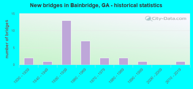
- New bridges - historical statistics
- 21930-1939
- 11940-1949
- 131950-1959
- 71960-1969
- 21970-1979
- 21980-1989
- 11990-1999
- 12010-2019


- Bridge Condition - Deck
- 9.1%Very good
- 77.3%Good
- 13.6%Satisfactory

- Bridge Condition - Superstructure
- 27.3%Very good
- 63.6%Good
- 9.1%Satisfactory

- Bridge Condition - Substructure
- 90.9%Good
- 9.1%Satisfactory

- Bridge Condition - Channel
- 28.6%Very good
- 42.9%Good
- 28.6%Satisfactory

- Bridge Condition - Culverts
- 85.7%Good
- 14.3%Satisfactory
Find on map >> Show street view
Structure Number: 870004, Location: BAINBRIDGE - SOUTHWEST SE (Lat: 30.896908, Lng: -84.584758), Route carried "on" structure: US 27, Year Built: 1962, Status: Open, Structure Length: 6.68m (21.92ft), Average Daily Traffic: 12,460 (year 2012), Truck Traffic: 1%, Average Future Daily Traffic: 18,690 (year 2032), Design Load: HS 20+Mod, Features Intersected: CSX RAILROAD
Minimum Vertical Clearance: 30+ m (98+ ft), Kilometerpoint: 32.187, Lanes on structure: 2, Base Highway Network: Yes, Owner: State Highway Agency, Approaching Roadway Width: 9.1m (29.9ft), Skew: 14 degrees, Material/Design: Steel continuous, Design/Construction: Stringer/Multi-beam, Number Of Spans In Main Unit: 3, Length of Maximum Span: 28.3m (92.8ft), Curb or Sidewalk Widths: Left: 0.6m (2.0ft), Right: 0.6m (2.0ft), Curb-To-Curb Width: 8.6m (28.2ft), Out-to-Out Width: 10.5m (34.4ft)
Condition: Deck: Good, Superstructure: Good, Substructure: Good, Operating Rating: 56.2 metric tons, Method Used To Determine Operating Rating: Load Factor (LF), Inventory Rating: 33.5 metric tons, Method Used To Determine Inventory Rating: Load Factor (LF), Structural Evaluation: Better than present minimum criteria, Deck Geometry: High priority of corrective action, Underclear: Somewhat better than minimum adequacy, Approach Roadway Alignment: Equal to present desirable criteria, Designated Inspection Frequency: Every 24 months, Inspection Date: October 2021, Bridge Improvement Cost: $856,000, Roadway Improvement Cost: $86,000, Total Project Cost: $1,284,000, Deck Structure Type: Concrete Cast-file-Place
Find on map >> Show street view
Structure Number: 870005, Location: BAINBRIDGE - SOUTHWEST- S (Lat: 30.896658, Lng: -84.584800), Route carried "on" structure: US 27, Year Built: 1962, Status: Open, Structure Length: 6.61m (21.69ft), Average Daily Traffic: 12,460 (year 2012), Truck Traffic: 1%, Average Future Daily Traffic: 18,690 (year 2032), Design Load: HS 20+Mod, Features Intersected: CSX RAILROAD
Minimum Vertical Clearance: 30+ m (98+ ft), Kilometerpoint: 32.187, Lanes on structure: 2, Base Highway Network: Yes, Owner: State Highway Agency, Approaching Roadway Width: 9.1m (29.9ft), Skew: 14 degrees, Material/Design: Steel continuous, Design/Construction: Stringer/Multi-beam, Number Of Spans In Main Unit: 3, Length of Maximum Span: 28.3m (92.8ft), Curb or Sidewalk Widths: Left: 0.6m (2.0ft), Right: 0.6m (2.0ft), Curb-To-Curb Width: 8.6m (28.2ft), Out-to-Out Width: 10.5m (34.4ft)
Condition: Deck: Good, Superstructure: Good, Substructure: Good, Operating Rating: 56.2 metric tons, Method Used To Determine Operating Rating: Load Factor (LF), Inventory Rating: 33.5 metric tons, Method Used To Determine Inventory Rating: Load Factor (LF), Structural Evaluation: Better than present minimum criteria, Deck Geometry: High priority of corrective action, Underclear: Somewhat better than minimum adequacy, Approach Roadway Alignment: Equal to present desirable criteria, Designated Inspection Frequency: Every 24 months, Inspection Date: October 2021, Bridge Improvement Cost: $848,000, Roadway Improvement Cost: $85,000, Total Project Cost: $1,272,000, Deck Structure Type: Concrete Cast-file-Place
Find on map >> Show street view
Structure Number: 870006, Location: SOUTH BAINBRIDGE-SHOTWELL (Lat: 30.904039, Lng: -84.586839), Route carried "on" structure: US 27, Year Built: 1959, Status: Open, Structure Length: 4.57m (14.99ft), Average Daily Traffic: 10,680 (year 2012), Truck Traffic: 18%, Average Future Daily Traffic: 16,020 (year 2032), Design Load: HS 20+Mod, Features Intersected: SR 38 BUS (US 84 BUS)
Minimum Vertical Clearance: 30+ m (98+ ft), Kilometerpoint: 33.796, Lanes on structure: 2, Lanes under structure: 4, Base Highway Network: Yes, Owner: State Highway Agency, Approaching Roadway Width: 9.1m (29.9ft), Skew: 10 degrees, Material/Design: Steel, Design/Construction: Stringer/Multi-beam, Number Of Spans In Main Unit: 3, Length of Maximum Span: 20.7m (67.9ft), Curb or Sidewalk Widths: Left: 0.6m (2.0ft), Right: 0.6m (2.0ft), Curb-To-Curb Width: 8.6m (28.2ft), Out-to-Out Width: 10.5m (34.4ft)
Condition: Deck: Satisfactory, Superstructure: Very good, Substructure: Good, Operating Rating: 33.5 metric tons, Method Used To Determine Operating Rating: Load Factor (LF), Inventory Rating: 19.9 metric tons, Method Used To Determine Inventory Rating: Load Factor (LF), Structural Evaluation: Somewhat better than minimum adequacy, Deck Geometry: High priority of replacement, Underclear: Somewhat better than minimum adequacy, Approach Roadway Alignment: Better than present minimum criteria, Designated Inspection Frequency: Every 24 months, Inspection Date: October 2021, Bridge Improvement Cost: $586,000, Roadway Improvement Cost: $59,000, Total Project Cost: $879,000, Deck Structure Type: Concrete Cast-file-Place
Find on map >> Show street view
Structure Number: 870007, Location: SOUTH BAINBRIDGE-SHOTWELL (Lat: 30.904078, Lng: -84.587108), Route carried "on" structure: US 27, Year Built: 1959, Status: Open, Structure Length: 4.57m (14.99ft), Average Daily Traffic: 10,680 (year 2012), Truck Traffic: 18%, Average Future Daily Traffic: 16,020 (year 2032), Design Load: HS 20+Mod, Features Intersected: SR 38 BUS (US 84 BUS)
Minimum Vertical Clearance: 30+ m (98+ ft), Kilometerpoint: 33.796, Lanes on structure: 2, Lanes under structure: 4, Base Highway Network: Yes, Owner: State Highway Agency, Approaching Roadway Width: 9.1m (29.9ft), Skew: 10 degrees, Material/Design: Steel, Design/Construction: Stringer/Multi-beam, Number Of Spans In Main Unit: 3, Length of Maximum Span: 20.7m (67.9ft), Curb or Sidewalk Widths: Left: 0.6m (2.0ft), Right: 0.6m (2.0ft), Curb-To-Curb Width: 8.6m (28.2ft), Out-to-Out Width: 10.5m (34.4ft)
Condition: Deck: Satisfactory, Superstructure: Good, Substructure: Good, Operating Rating: 34.4 metric tons, Method Used To Determine Operating Rating: Load Factor (LF), Inventory Rating: 19.9 metric tons, Method Used To Determine Inventory Rating: Load Factor (LF), Structural Evaluation: Somewhat better than minimum adequacy, Deck Geometry: High priority of replacement, Underclear: Equal to present desirable criteria, Approach Roadway Alignment: Equal to present desirable criteria, Designated Inspection Frequency: Every 24 months, Inspection Date: October 2021, Bridge Improvement Cost: $586,000, Roadway Improvement Cost: $59,000, Total Project Cost: $879,000, Deck Structure Type: Concrete Cast-file-Place
Find on map >> Show street view
Structure Number: 870008, Location: BAINBRIDGE - SW SECTION (Lat: 30.906369, Lng: -84.588658), Route carried "on" structure: US 27, Year Built: 1959, Status: Open, Structure Length: 27.04m (88.71ft), Average Daily Traffic: 10,680 (year 2012), Truck Traffic: 18%, Average Future Daily Traffic: 16,020 (year 2032), Design Load: HS 20+Mod, Features Intersected: FLINT RIVER- CSX RR
Minimum Vertical Clearance: 30+ m (98+ ft), Kilometerpoint: 33.796, Lanes on structure: 2, Base Highway Network: Yes, Owner: State Highway Agency, Approaching Roadway Width: 9.1m (29.9ft), Skew: 19 degrees, Navigation Control: Yes ( Vertical Clearance: 11.2m (36.7ft), Horizontal Clearance: 36.5m (119.8ft)), Material/Design: Steel continuous, Design/Construction: Girder and Floorbeam System, Number Of Spans In Main Unit: 3, Number Of Approach Spans: 8, Length of Maximum Span: 61.6m (202.1ft), Curb or Sidewalk Widths: Left: 0.6m (2.0ft), Right: 0.6m (2.0ft), Curb-To-Curb Width: 8.6m (28.2ft), Out-to-Out Width: 10.5m (34.4ft)
Condition: Deck: Good, Superstructure: Satisfactory, Substructure: Satisfactory, Channel: Satisfactory, Operating Rating: 35.3 metric tons, Method Used To Determine Operating Rating: Load Factor (LF), Inventory Rating: 20.8 metric tons, Method Used To Determine Inventory Rating: Load Factor (LF), Structural Evaluation: Somewhat better than minimum adequacy, Deck Geometry: High priority of corrective action, Underclear: Equal to present minimum criteria, Waterway Adequacy: Equal to present desirable criteria, Approach Roadway Alignment: Better than present minimum criteria, Designated Inspection Frequency: Every 24 months, Critical Feature Inspection Frequency: Every 24 months, Underwater Inspection Frequency: Every 60 months, Inspection Date: September 2021, Critical Feature Inspection Date: August 2020, Underwater Inspection Date: October 2020, Bridge Improvement Cost: $3,466,000, Roadway Improvement Cost: $347,000, Total Project Cost: $5,199,000, Deck Structure Type: Concrete Cast-file-Place
Find on map >> Show street view
Structure Number: 870009, Location: BAINBRIDGE - SW SECTION (Lat: 30.906308, Lng: -84.588939), Route carried "on" structure: US 27, Year Built: 1959, Status: Open, Structure Length: 27.04m (88.71ft), Average Daily Traffic: 10,680 (year 2012), Truck Traffic: 18%, Average Future Daily Traffic: 16,020 (year 2032), Design Load: HS 20+Mod, Features Intersected: FLINT RIVER- CSX RR
Minimum Vertical Clearance: 30+ m (98+ ft), Kilometerpoint: 33.796, Lanes on structure: 2, Base Highway Network: Yes, Owner: State Highway Agency, Approaching Roadway Width: 9.1m (29.9ft), Skew: 19 degrees, Navigation Control: Yes ( Vertical Clearance: 11.2m (36.7ft), Horizontal Clearance: 36.5m (119.8ft)), Material/Design: Steel continuous, Design/Construction: Girder and Floorbeam System, Number Of Spans In Main Unit: 3, Number Of Approach Spans: 8, Length of Maximum Span: 61.6m (202.1ft), Curb or Sidewalk Widths: Left: 0.6m (2.0ft), Right: 0.6m (2.0ft), Curb-To-Curb Width: 8.6m (28.2ft), Out-to-Out Width: 10.5m (34.4ft)
Condition: Deck: Good, Superstructure: Satisfactory, Substructure: Satisfactory, Channel: Good, Operating Rating: 35.3 metric tons, Method Used To Determine Operating Rating: Load Factor (LF), Inventory Rating: 20.8 metric tons, Method Used To Determine Inventory Rating: Load Factor (LF), Structural Evaluation: Somewhat better than minimum adequacy, Deck Geometry: High priority of corrective action, Underclear: Equal to present minimum criteria, Waterway Adequacy: Equal to present desirable criteria, Approach Roadway Alignment: Better than present minimum criteria, Designated Inspection Frequency: Every 24 months, Critical Feature Inspection Frequency: Every 24 months, Underwater Inspection Frequency: Every 60 months, Inspection Date: September 2021, Critical Feature Inspection Date: August 2020, Underwater Inspection Date: October 2020, Bridge Improvement Cost: $3,466,000, Roadway Improvement Cost: $347,000, Total Project Cost: $5,199,000, Deck Structure Type: Concrete Cast-file-Place, Wearing Surface/Protective System: Wearing Surface: Epoxy Overlay
Find on map >> Show street view
Structure Number: 87001, Location: BAINBRIDGE - NORTHWEST SE (Lat: 30.919378, Lng: -84.600878), Route carried "on" structure: US 27, Year Built: 1959, Status: Open, Structure Length: 6.34m (20.80ft), Average Daily Traffic: 11,090 (year 2012), Truck Traffic: 20%, Average Future Daily Traffic: 16,635 (year 2032), Design Load: HS 20+Mod, Features Intersected: SR 1B DOTHAN RD (US 27B)
Minimum Vertical Clearance: 30+ m (98+ ft), Kilometerpoint: 35.406, Lanes on structure: 2, Lanes under structure: 4, Base Highway Network: Yes, Owner: State Highway Agency, Approaching Roadway Width: 9.1m (29.9ft), Skew: 14 degrees, Material/Design: Prestressed concrete, Design/Construction: Stringer/Multi-beam, Number Of Spans In Main Unit: 4, Length of Maximum Span: 18.6m (61.0ft), Curb or Sidewalk Widths: Left: 0.6m (2.0ft), Right: 0.6m (2.0ft), Curb-To-Curb Width: 8.6m (28.2ft), Out-to-Out Width: 10.5m (34.4ft)
Condition: Deck: Good, Superstructure: Good, Substructure: Good, Operating Rating: 44.4 metric tons, Method Used To Determine Operating Rating: Load Factor (LF), Inventory Rating: 26.3 metric tons, Method Used To Determine Inventory Rating: Load Factor (LF), Structural Evaluation: Equal to present minimum criteria, Deck Geometry: High priority of corrective action, Underclear: Somewhat better than minimum adequacy, Approach Roadway Alignment: Equal to present desirable criteria, Designated Inspection Frequency: Every 24 months, Inspection Date: October 2021, Bridge Improvement Cost: $813,000, Roadway Improvement Cost: $81,000, Total Project Cost: $1,219,000, Deck Structure Type: Concrete Cast-file-Place
Find on map >> Show street view
Structure Number: 870011, Location: BAINBRIDGE - NW SECTION (Lat: 30.919539, Lng: -84.601189), Route carried "on" structure: US 27, Year Built: 1959, Status: Open, Structure Length: 6.34m (20.80ft), Average Daily Traffic: 6,550 (year 2012), Truck Traffic: 1%, Average Future Daily Traffic: 9,825 (year 2032), Design Load: HS 20+Mod, Features Intersected: SR 1B DOTHAN RD (US 27B)
Minimum Vertical Clearance: 30+ m (98+ ft), Kilometerpoint: 35.406, Lanes on structure: 2, Lanes under structure: 4, Base Highway Network: Yes, Owner: State Highway Agency, Approaching Roadway Width: 9.1m (29.9ft), Skew: 14 degrees, Material/Design: Prestressed concrete, Design/Construction: Stringer/Multi-beam, Number Of Spans In Main Unit: 4, Length of Maximum Span: 18.6m (61.0ft), Curb or Sidewalk Widths: Left: 0.6m (2.0ft), Right: 0.6m (2.0ft), Curb-To-Curb Width: 8.6m (28.2ft), Out-to-Out Width: 10.5m (34.4ft)
Condition: Deck: Good, Superstructure: Good, Substructure: Good, Operating Rating: 44.4 metric tons, Method Used To Determine Operating Rating: Load Factor (LF), Inventory Rating: 26.3 metric tons, Method Used To Determine Inventory Rating: Load Factor (LF), Structural Evaluation: Equal to present minimum criteria, Deck Geometry: High priority of corrective action, Underclear: Somewhat better than minimum adequacy, Approach Roadway Alignment: Equal to present desirable criteria, Designated Inspection Frequency: Every 24 months, Inspection Date: October 2021, Bridge Improvement Cost: $813,000, Roadway Improvement Cost: $81,000, Total Project Cost: $1,219,000, Deck Structure Type: Concrete Cast-file-Place
Find on map >> Show street view
Structure Number: 870012, Location: BAINBRIDGE - NORTHWEST SE (Lat: 30.922789, Lng: -84.602189), Route carried "on" structure: US 27, Year Built: 1959, Status: Open, Structure Length: 5.18m (16.99ft), Average Daily Traffic: 6,550 (year 2012), Truck Traffic: 1%, Average Future Daily Traffic: 9,825 (year 2032), Design Load: HS 20+Mod, Features Intersected: CSX RAILROAD
Minimum Vertical Clearance: 30+ m (98+ ft), Kilometerpoint: 37.015, Lanes on structure: 2, Base Highway Network: Yes, Owner: State Highway Agency, Approaching Roadway Width: 7.3m (24.0ft), Skew: 13 degrees, Material/Design: Steel continuous, Design/Construction: Stringer/Multi-beam, Number Of Spans In Main Unit: 4, Length of Maximum Span: 15.8m (51.8ft), Curb or Sidewalk Widths: Left: 0.6m (2.0ft), Right: 0.6m (2.0ft), Curb-To-Curb Width: 8.6m (28.2ft), Out-to-Out Width: 9.8m (32.2ft)
Condition: Deck: Good, Superstructure: Good, Substructure: Good, Operating Rating: 35.3 metric tons, Method Used To Determine Operating Rating: Load Factor (LF), Inventory Rating: 20.8 metric tons, Method Used To Determine Inventory Rating: Load Factor (LF), Structural Evaluation: Somewhat better than minimum adequacy, Deck Geometry: High priority of corrective action, Underclear: Meets minimum limits, Approach Roadway Alignment: Equal to present desirable criteria, Designated Inspection Frequency: Every 24 months, Inspection Date: October 2021, Bridge Improvement Cost: $664,000, Roadway Improvement Cost: $66,000, Total Project Cost: $996,000, Deck Structure Type: Concrete Cast-file-Place
Find on map >> Show street view
Structure Number: 870013, Location: BAINBRIDGE - NORTHWEST SE (Lat: 30.922969, Lng: -84.602508), Route carried "on" structure: US 27, Year Built: 1959, Status: Open, Structure Length: 5.18m (16.99ft), Average Daily Traffic: 6,550 (year 2012), Truck Traffic: 1%, Average Future Daily Traffic: 9,825 (year 2032), Design Load: HS 20+Mod, Features Intersected: CSX RAILROAD
Minimum Vertical Clearance: 30+ m (98+ ft), Kilometerpoint: 37.015, Lanes on structure: 2, Base Highway Network: Yes, Owner: State Highway Agency, Approaching Roadway Width: 7.3m (24.0ft), Skew: 13 degrees, Material/Design: Steel continuous, Design/Construction: Stringer/Multi-beam, Number Of Spans In Main Unit: 4, Length of Maximum Span: 15.8m (51.8ft), Curb or Sidewalk Widths: Left: 0.6m (2.0ft), Right: 0.6m (2.0ft), Curb-To-Curb Width: 8.6m (28.2ft), Out-to-Out Width: 9.8m (32.2ft)
Condition: Deck: Good, Superstructure: Very good, Substructure: Good, Operating Rating: 35.3 metric tons, Method Used To Determine Operating Rating: Load Factor (LF), Inventory Rating: 20.8 metric tons, Method Used To Determine Inventory Rating: Load Factor (LF), Structural Evaluation: Somewhat better than minimum adequacy, Deck Geometry: High priority of corrective action, Underclear: Meets minimum limits, Approach Roadway Alignment: Equal to present desirable criteria, Designated Inspection Frequency: Every 24 months, Inspection Date: October 2021, Bridge Improvement Cost: $664,000, Roadway Improvement Cost: $66,000, Total Project Cost: $996,000, Deck Structure Type: Concrete Cast-file-Place
Find on map >> Show street view
Structure Number: 870014, Location: DOWNTOWN BAINBRIDGE (Lat: 30.910428, Lng: -84.580378), Route carried "on" structure: Business US 27, Year Built: 1975, Status: Open, Structure Length: 25.73m (84.42ft), Average Daily Traffic: 11,320 (year 2012), Truck Traffic: 1%, Average Future Daily Traffic: 16,980 (year 2032), Design Load: HS 20+Mod, Features Intersected: FLINT RIVER
Minimum Vertical Clearance: 30+ m (98+ ft), Kilometerpoint: 3.219, Lanes on structure: 4, Base Highway Network: Yes, Owner: State Highway Agency, Approaching Roadway Width: 15.8m (51.8ft), Skew: 4 degrees, Navigation Control: Yes ( Vertical Clearance: 12.1m (39.7ft), Horizontal Clearance: 53.3m (174.9ft)), Material/Design: Steel continuous, Design/Construction: Stringer/Multi-beam, Number Of Spans In Main Unit: 5, Length of Maximum Span: 57.3m (188.0ft), Curb or Sidewalk Widths: Left: 3.7m (12.1ft), Right: 3.7m (12.1ft), Curb-To-Curb Width: 15.8m (51.8ft), Out-to-Out Width: 23.8m (78.1ft)
Condition: Deck: Good, Superstructure: Good, Substructure: Good, Channel: Good, Operating Rating: 41.7 metric tons, Method Used To Determine Operating Rating: Load Factor (LF), Inventory Rating: 25.4 metric tons, Method Used To Determine Inventory Rating: Load Factor (LF), Structural Evaluation: Equal to present minimum criteria, Deck Geometry: Meets minimum limits, Waterway Adequacy: Equal to present desirable criteria, Approach Roadway Alignment: Equal to present desirable criteria, Designated Inspection Frequency: Every 24 months, Underwater Inspection Frequency: Every 60 months, Inspection Date: September 2021, Underwater Inspection Date: October 2020, Bridge Improvement Cost: $5,096,000, Roadway Improvement Cost: $510,000, Total Project Cost: $7,645,000, Deck Structure Type: Concrete Cast-file-Place
Find on map >> Show street view
Structure Number: 870016, Location: BAINBRIDGE - SOUTHEAST SE (Lat: 30.890342, Lng: -84.566369), Route carried "on" structure: US 84, Year Built: 1962, Status: Open, Structure Length: 4.60m (15.09ft), Average Daily Traffic: 8,390 (year 2012), Truck Traffic: 1%, Average Future Daily Traffic: 12,585 (year 2032), Design Load: HS 20+Mod, Features Intersected: SR1 TALLAHASSEE RD US27
Minimum Vertical Clearance: 30+ m (98+ ft), Kilometerpoint: 20.921, Lanes on structure: 2, Lanes under structure: 2, Base Highway Network: Yes, Owner: State Highway Agency, Approaching Roadway Width: 9.1m (29.9ft), Skew: 10 degrees, Material/Design: Steel, Design/Construction: Stringer/Multi-beam, Number Of Spans In Main Unit: 3, Length of Maximum Span: 21.6m (70.9ft), Curb or Sidewalk Widths: Left: 0.6m (2.0ft), Right: 0.6m (2.0ft), Curb-To-Curb Width: 8.7m (28.5ft), Out-to-Out Width: 10.5m (34.4ft)
Condition: Deck: Good, Superstructure: Very good, Substructure: Good, Operating Rating: 32.6 metric tons, Method Used To Determine Operating Rating: Load Factor (LF), Inventory Rating: 19.0 metric tons, Method Used To Determine Inventory Rating: Load Factor (LF), Structural Evaluation: Meets minimum limits, Deck Geometry: High priority of replacement, Underclear: Somewhat better than minimum adequacy, Approach Roadway Alignment: Equal to present desirable criteria, Designated Inspection Frequency: Every 24 months, Inspection Date: October 2021, Bridge Improvement Cost: $590,000, Roadway Improvement Cost: $59,000, Total Project Cost: $885,000, Deck Structure Type: Concrete Cast-file-Place
Find on map >> Show street view
Structure Number: 870017, Location: BAINBRIDGE - SOUTHEAST SE (Lat: 30.890519, Lng: -84.566419), Route carried "on" structure: US 84, Year Built: 1962, Status: Open, Structure Length: 4.60m (15.09ft), Average Daily Traffic: 7,800 (year 2010), Truck Traffic: 3%, Average Future Daily Traffic: 11,700 (year 2030), Design Load: HS 20+Mod, Features Intersected: SR1 TALLAHASSEE RD US27
Minimum Vertical Clearance: 30+ m (98+ ft), Kilometerpoint: 20.921, Lanes on structure: 2, Lanes under structure: 2, Base Highway Network: Yes, Owner: State Highway Agency, Approaching Roadway Width: 9.1m (29.9ft), Skew: 10 degrees, Material/Design: Steel, Design/Construction: Stringer/Multi-beam, Number Of Spans In Main Unit: 3, Length of Maximum Span: 21.6m (70.9ft), Curb or Sidewalk Widths: Left: 0.6m (2.0ft), Right: 0.6m (2.0ft), Curb-To-Curb Width: 8.7m (28.5ft), Out-to-Out Width: 10.5m (34.4ft)
Condition: Deck: Good, Superstructure: Very good, Substructure: Good, Operating Rating: 32.6 metric tons, Method Used To Determine Operating Rating: Load Factor (LF), Inventory Rating: 19.9 metric tons, Method Used To Determine Inventory Rating: Load Factor (LF), Structural Evaluation: Somewhat better than minimum adequacy, Deck Geometry: High priority of replacement, Underclear: Somewhat better than minimum adequacy, Approach Roadway Alignment: Equal to present desirable criteria, Designated Inspection Frequency: Every 24 months, Inspection Date: October 2021, Bridge Improvement Cost: $590,000, Roadway Improvement Cost: $59,000, Total Project Cost: $885,000, Deck Structure Type: Concrete Cast-file-Place
Find on map >> Show street view
Structure Number: 870018, Location: APP 5 MI E OF BAINBRIDGE (Lat: 30.890850, Lng: -84.490219), Route carried "on" structure: US 84, Year Built: 1930, Year Reconstructed: 1988, Status: Open, Structure Length: 0.79m (2.59ft), Average Daily Traffic: 5,280 (year 2012), Truck Traffic: 1%, Average Future Daily Traffic: 7,920 (year 2032), Design Load: H 15, Features Intersected: BIG SLOUGH TRIB
Minimum Vertical Clearance: 30+ m (98+ ft), Kilometerpoint: 28.968, Lanes on structure: 4, Base Highway Network: Yes, Owner: State Highway Agency, Approaching Roadway Width: 18.3m (60.0ft), Skew: 10 degrees, Material/Design: Concrete, Design/Construction: Culvert, Number Of Spans In Main Unit: 3, Length of Maximum Span: 2.4m (7.9ft)
Condition: Channel: Satisfactory, Culverts: Good, Operating Rating: 47.1 metric tons, Method Used To Determine Operating Rating: Load Factor (LF), Inventory Rating: 28.1 metric tons, Method Used To Determine Inventory Rating: Load Factor (LF), Structural Evaluation: Better than present minimum criteria, Waterway Adequacy: Equal to present minimum criteria, Approach Roadway Alignment: Equal to present desirable criteria, Designated Inspection Frequency: Every 24 months, Inspection Date: September 2021, Bridge Improvement Cost: $157,000, Roadway Improvement Cost: $16,000, Total Project Cost: $235,000
Find on map >> Show street view
Structure Number: 870021, Location: BAINBRIDGE - SOUTHWEST SE (Lat: 30.904028, Lng: -84.582928), Route carried "on" structure: Business US 84, Year Built: 1959, Status: Open, Structure Length: 5.85m (19.19ft), Average Daily Traffic: 7,330 (year 2012), Truck Traffic: 1%, Average Future Daily Traffic: 10,995 (year 2032), Design Load: HS 20+Mod, Features Intersected: CSX RAILROAD
Minimum Vertical Clearance: 30+ m (98+ ft), Kilometerpoint: 0.000, Lanes on structure: 4, Base Highway Network: Yes, Owner: State Highway Agency, Approaching Roadway Width: 18.6m (61.0ft), Material/Design: Prestressed concrete, Design/Construction: Stringer/Multi-beam, Number Of Spans In Main Unit: 3, Length of Maximum Span: 23.2m (76.1ft), Curb or Sidewalk Widths: Left: 1.5m (4.9ft), Right: 0.6m (2.0ft), Curb-To-Curb Width: 18.6m (61.0ft), Out-to-Out Width: 21.3m (69.9ft)
Condition: Deck: Satisfactory, Superstructure: Good, Substructure: Good, Operating Rating: 65.3 metric tons, Method Used To Determine Operating Rating: Load Factor (LF), Inventory Rating: 41.7 metric tons, Method Used To Determine Inventory Rating: Load Factor (LF), Structural Evaluation: Better than present minimum criteria, Deck Geometry: Equal to present minimum criteria, Underclear: Equal to present minimum criteria, Approach Roadway Alignment: Equal to present desirable criteria, Designated Inspection Frequency: Every 24 months, Inspection Date: September 2021, Bridge Improvement Cost: $1,159,000, Roadway Improvement Cost: $116,000, Total Project Cost: $1,739,000, Deck Structure Type: Concrete Cast-file-Place
Find on map >> Show street view
Structure Number: 870023, Location: 4.5 MI SW OF BAINBRIDGE (Lat: 30.856808, Lng: -84.614458), Route carried "on" structure: State highway 97, Year Built: 1946, Status: Open, Structure Length: 1.10m (3.61ft), Average Daily Traffic: 2,710 (year 2012), Truck Traffic: 1%, Average Future Daily Traffic: 4,065 (year 2032), Design Load: H 15, Features Intersected: FOUR MILE CREEK
Minimum Vertical Clearance: 30+ m (98+ ft), Kilometerpoint: 28.968, Lanes on structure: 2, Base Highway Network: Yes, Owner: State Highway Agency, Approaching Roadway Width: 7.3m (24.0ft), Skew: 2 degrees, Material/Design: Concrete, Design/Construction: Culvert, Number Of Spans In Main Unit: 3, Length of Maximum Span: 3.4m (11.2ft)
Condition: Channel: Good, Culverts: Satisfactory, Operating Rating: 35.3 metric tons, Method Used To Determine Operating Rating: Load Factor (LF), Inventory Rating: 20.8 metric tons, Method Used To Determine Inventory Rating: Load Factor (LF), Structural Evaluation: Somewhat better than minimum adequacy, Waterway Adequacy: Equal to present desirable criteria, Approach Roadway Alignment: Better than present minimum criteria, Designated Inspection Frequency: Every 24 months, Inspection Date: September 2021, Bridge Improvement Cost: $141,000, Roadway Improvement Cost: $14,000, Total Project Cost: $211,000
Find on map >> Show street view
Structure Number: 870024, Location: BAINBRIDGE - SOUTHSIDE (Lat: 30.893000, Lng: -84.579689), Route carried "on" structure: State highway 97, Year Built: 1962, Status: Open, Structure Length: 7.01m (23.00ft), Average Daily Traffic: 4,720 (year 2012), Truck Traffic: 1%, Average Future Daily Traffic: 7,080 (year 2032), Design Load: HS 20+Mod, Features Intersected: SR 1 (US 27-US 84-SR 38)
Minimum Vertical Clearance: 30+ m (98+ ft), Kilometerpoint: 33.796, Lanes on structure: 2, Lanes under structure: 4, Base Highway Network: Yes, Owner: State Highway Agency, Approaching Roadway Width: 7.3m (24.0ft), Skew: 2 degrees, Material/Design: Steel continuous, Design/Construction: Stringer/Multi-beam, Number Of Spans In Main Unit: 4, Length of Maximum Span: 19.8m (65.0ft), Curb or Sidewalk Widths: Left: 1.5m (4.9ft), Right: 1.5m (4.9ft), Curb-To-Curb Width: 8.6m (28.2ft), Out-to-Out Width: 12.3m (40.4ft)
Condition: Deck: Very good, Superstructure: Good, Substructure: Good, Operating Rating: 42.6 metric tons, Method Used To Determine Operating Rating: Load Factor (LF), Inventory Rating: 25.4 metric tons, Method Used To Determine Inventory Rating: Load Factor (LF), Structural Evaluation: Equal to present minimum criteria, Deck Geometry: Meets minimum limits, Underclear: Equal to present minimum criteria, Approach Roadway Alignment: Equal to present desirable criteria, Designated Inspection Frequency: Every 24 months, Inspection Date: October 2021, Bridge Improvement Cost: $899,000, Roadway Improvement Cost: $90,000, Total Project Cost: $1,348,000, Deck Structure Type: Concrete Cast-file-Place, Wearing Surface/Protective System: Wearing Surface: Epoxy Overlay
Find on map >> Show street view
Structure Number: 870028, Location: BAINBRIDGE - W SECTION (Lat: 30.911400, Lng: -84.594128), Route carried "on" structure: State highway 253, Year Built: 1959, Status: Open, Structure Length: 6.68m (21.92ft), Average Daily Traffic: 4,490 (year 2012), Truck Traffic: 1%, Average Future Daily Traffic: 6,735 (year 2032), Design Load: HS 20+Mod, Features Intersected: SR 1 (US 27-US 84-SR 38)
Minimum Vertical Clearance: 30+ m (98+ ft), Kilometerpoint: 17.703, Lanes on structure: 2, Lanes under structure: 4, Base Highway Network: Yes, Owner: State Highway Agency, Approaching Roadway Width: 7.3m (24.0ft), Material/Design: Prestressed concrete, Design/Construction: Stringer/Multi-beam, Number Of Spans In Main Unit: 4, Length of Maximum Span: 18.6m (61.0ft), Curb or Sidewalk Widths: Left: 1.5m (4.9ft), Right: 1.5m (4.9ft), Curb-To-Curb Width: 8.6m (28.2ft), Out-to-Out Width: 12.3m (40.4ft)
Condition: Deck: Good, Superstructure: Good, Substructure: Good, Operating Rating: 52.6 metric tons, Method Used To Determine Operating Rating: Load Factor (LF), Inventory Rating: 25.4 metric tons, Method Used To Determine Inventory Rating: Load Factor (LF), Structural Evaluation: Equal to present minimum criteria, Deck Geometry: Meets minimum limits, Underclear: Meets minimum limits, Approach Roadway Alignment: Equal to present desirable criteria, Designated Inspection Frequency: Every 24 months, Inspection Date: October 2021, Bridge Improvement Cost: $856,000, Roadway Improvement Cost: $86,000, Total Project Cost: $1,284,000, Deck Structure Type: Concrete Cast-file-Place
Find on map >> Show street view
Structure Number: 870033, Location: 3.5 MILES SOUTH OF BAINBR (Lat: 30.854128, Lng: -84.568008), Route carried "on" structure: State highway 309, Year Built: 1955, Status: Open, Structure Length: 1.01m (3.31ft), Average Daily Traffic: 1,400 (year 2012), Truck Traffic: 1%, Average Future Daily Traffic: 2,100 (year 2032), Design Load: H 15, Features Intersected: FOUR MILE CREEK
Minimum Vertical Clearance: 30+ m (98+ ft), Kilometerpoint: 19.312, Lanes on structure: 2, Base Highway Network: Yes, Owner: State Highway Agency, Approaching Roadway Width: 7.9m (25.9ft), Material/Design: Concrete, Design/Construction: Culvert, Number Of Spans In Main Unit: 3, Length of Maximum Span: 3.0m (9.8ft)
Condition: Channel: Satisfactory, Culverts: Good, Operating Rating: 50.8 metric tons, Method Used To Determine Operating Rating: Load Factor (LF), Inventory Rating: 30.8 metric tons, Method Used To Determine Inventory Rating: Load Factor (LF), Structural Evaluation: Better than present minimum criteria, Waterway Adequacy: Equal to present desirable criteria, Approach Roadway Alignment: Equal to present desirable criteria, Designated Inspection Frequency: Every 24 months, Inspection Date: September 2021, Bridge Improvement Cost: $129,000, Roadway Improvement Cost: $13,000, Total Project Cost: $193,000
Find on map >> Show street view
Structure Number: 870034, Location: BAINBRIDGE - SOUTHSIDE (Lat: 30.892250, Lng: -84.576400), Route carried "on" structure: State highway 309, Year Built: 1962, Status: Open, Structure Length: 6.22m (20.41ft), Average Daily Traffic: 6,650 (year 2012), Truck Traffic: 1%, Average Future Daily Traffic: 9,975 (year 2032), Design Load: HS 20+Mod, Features Intersected: SR 1 (US 27-US 84-SR 38), Facility Carried by Structure: WEST STREET
Minimum Vertical Clearance: 30+ m (98+ ft), Kilometerpoint: 24.140, Lanes on structure: 2, Lanes under structure: 4, Base Highway Network: Yes, Owner: State Highway Agency, Approaching Roadway Width: 9.8m (32.2ft), Material/Design: Steel continuous, Design/Construction: Stringer/Multi-beam, Number Of Spans In Main Unit: 4, Length of Maximum Span: 17.1m (56.1ft), Curb or Sidewalk Widths: Left: 1.5m (4.9ft), Right: 1.5m (4.9ft), Curb-To-Curb Width: 9.8m (32.2ft), Out-to-Out Width: 13.5m (44.3ft)
Condition: Deck: Good, Superstructure: Very good, Substructure: Good, Operating Rating: 39.0 metric tons, Method Used To Determine Operating Rating: Load Factor (LF), Inventory Rating: 23.5 metric tons, Method Used To Determine Inventory Rating: Load Factor (LF), Structural Evaluation: Somewhat better than minimum adequacy, Deck Geometry: Meets minimum limits, Underclear: High priority of corrective action, Approach Roadway Alignment: Equal to present desirable criteria, Designated Inspection Frequency: Every 24 months, Inspection Date: October 2021, Bridge Improvement Cost: $797,000, Roadway Improvement Cost: $80,000, Total Project Cost: $1,196,000, Deck Structure Type: Concrete Cast-file-Place
Find on map >> Show street view
Structure Number: 870036, Location: 1.7 MI N OF BAINBRIDGE (Lat: 30.935828, Lng: -84.549719), Route carried "on" structure: State highway 311, Year Built: 1959, Status: Open, Structure Length: 4.66m (15.29ft), Average Daily Traffic: 1,720 (year 2012), Truck Traffic: 8%, Average Future Daily Traffic: 2,580 (year 2032), Design Load: H 15, Features Intersected: BIG SLOUGH
Minimum Vertical Clearance: 30+ m (98+ ft), Kilometerpoint: 3.219, Lanes on structure: 2, Base Highway Network: Yes, Owner: State Highway Agency, Approaching Roadway Width: 6.1m (20.0ft), Material/Design: Concrete, Design/Construction: Tee Beam, Number Of Spans In Main Unit: 5, Length of Maximum Span: 10.1m (33.1ft), Curb or Sidewalk Widths: Left: 0.6m (2.0ft), Right: 0.6m (2.0ft), Curb-To-Curb Width: 7.3m (24.0ft), Out-to-Out Width: 9.2m (30.2ft)
Condition: Deck: Good, Superstructure: Good, Substructure: Good, Channel: Very good, Operating Rating: 34.4 metric tons, Method Used To Determine Operating Rating: Allowable Stress (AS), Inventory Rating: 21.7 metric tons, Method Used To Determine Inventory Rating: Allowable Stress (AS), Structural Evaluation: Somewhat better than minimum adequacy, Deck Geometry: Meets minimum limits, Waterway Adequacy: Equal to present desirable criteria, Approach Roadway Alignment: Equal to present desirable criteria, Length Of Structure Improvement: 11.09m (36.38ft), Designated Inspection Frequency: Every 24 months, Inspection Date: September 2021, Bridge Improvement Cost: $598,000, Roadway Improvement Cost: $60,000, Total Project Cost: $897,000, Deck Structure Type: Concrete Cast-file-Place
Find on map >> Show street view
Structure Number: 870037, Location: BAINBRIDGE - SE SECTION (Lat: 30.890269, Lng: -84.562019), Route carried "on" structure: City street 412, Year Built: 1962, Status: Open, Structure Length: 7.25m (23.79ft), Average Daily Traffic: 2,630 (year 2012), Truck Traffic: 1%, Average Future Daily Traffic: 3,945 (year 2032), Design Load: HS 20+Mod, Features Intersected: SR 38 (US 84), Facility Carried by Structure: LAKE DOUGLAS RD
Minimum Vertical Clearance: 30+ m (98+ ft), Kilometerpoint: 1.609, Lanes on structure: 2, Lanes under structure: 4, Base Highway Network: Yes, Owner: State Highway Agency, Approaching Roadway Width: 11.0m (36.1ft), Skew: 3 degrees, Material/Design: Steel continuous, Design/Construction: Stringer/Multi-beam, Number Of Spans In Main Unit: 4, Length of Maximum Span: 21.0m (68.9ft), Curb or Sidewalk Widths: Left: 1.5m (4.9ft), Right: 1.5m (4.9ft), Curb-To-Curb Width: 9.8m (32.2ft), Out-to-Out Width: 13.6m (44.6ft)
Condition: Deck: Very good, Superstructure: Very good, Substructure: Good, Operating Rating: 39.9 metric tons, Method Used To Determine Operating Rating: Load Factor (LF), Inventory Rating: 23.5 metric tons, Method Used To Determine Inventory Rating: Load Factor (LF), Structural Evaluation: Equal to present minimum criteria, Deck Geometry: Meets minimum limits, Underclear: Meets minimum limits, Approach Roadway Alignment: Equal to present desirable criteria, Designated Inspection Frequency: Every 24 months, Inspection Date: October 2021, Bridge Improvement Cost: $930,000, Roadway Improvement Cost: $93,000, Total Project Cost: $1,395,000, Deck Structure Type: Concrete Cast-file-Place, Wearing Surface/Protective System: Wearing Surface: Epoxy Overlay
Find on map >> Show street view
Structure Number: 870044, Location: 4.7 MI E OF BAINBRIDGE (Lat: 30.907678, Lng: -84.495658), Route carried "on" structure: County highway 2713, Year Built: 1958, Status: Open, Structure Length: 0.82m (2.69ft), Average Daily Traffic: 580 (year 2012), Truck Traffic: 1%, Average Future Daily Traffic: 870 (year 2032), Design Load: H 15, Features Intersected: BIG SLOUGH TRIB, Facility Carried by Structure: OLD WHIGHAM RD
Minimum Vertical Clearance: 30+ m (98+ ft), Kilometerpoint: 8.047, Lanes on structure: 2, Base Highway Network: Yes, Owner: County Highway Agency, Approaching Roadway Width: 6.1m (20.0ft), Material/Design: Concrete, Design/Construction: Culvert, Number Of Spans In Main Unit: 3, Length of Maximum Span: 2.4m (7.9ft)
Condition: Channel: Satisfactory, Culverts: Good, Operating Rating: 41.7 metric tons, Method Used To Determine Operating Rating: Field evaluation and documented engineering judgment, Inventory Rating: 24.4 metric tons, Method Used To Determine Inventory Rating: Field evaluation and documented engineering judgment, Structural Evaluation: Equal to present minimum criteria, Waterway Adequacy: Equal to present minimum criteria, Approach Roadway Alignment: Equal to present desirable criteria, Designated Inspection Frequency: Every 24 months, Inspection Date: September 2021, Bridge Improvement Cost: $105,000, Roadway Improvement Cost: $11,000, Total Project Cost: $158,000
Find on map >> Show street view
Structure Number: 875049, Location: 3.4 MI NE OF BAINBRIDGE (Lat: 30.937378, Lng: -84.530328), Route carried "on" structure: County highway 318, Year Built: 1980, Status: Open, Structure Length: 4.88m (16.01ft), Average Daily Traffic: 490 (year 2012), Truck Traffic: 1%, Average Future Daily Traffic: 735 (year 2032), Design Load: HS 15, Features Intersected: BIG SLOUGH, Facility Carried by Structure: MILLS ROAD
Minimum Vertical Clearance: 30+ m (98+ ft), Kilometerpoint: 0.000, Lanes on structure: 2, Base Highway Network: Yes, Owner: County Highway Agency, Approaching Roadway Width: 6.1m (20.0ft), Material/Design: Concrete, Design/Construction: Slab, Number Of Spans In Main Unit: 8, Length of Maximum Span: 6.1m (20.0ft), Curb-To-Curb Width: 9.8m (32.2ft), Out-to-Out Width: 10.6m (34.8ft)
Condition: Deck: Good, Superstructure: Good, Substructure: Good, Channel: Good, Operating Rating: 45.3 metric tons, Method Used To Determine Operating Rating: Allowable Stress (AS), Inventory Rating: 27.2 metric tons, Method Used To Determine Inventory Rating: Allowable Stress (AS), Structural Evaluation: Equal to present minimum criteria, Deck Geometry: Equal to present minimum criteria, Waterway Adequacy: Equal to present desirable criteria, Approach Roadway Alignment: Equal to present desirable criteria, Designated Inspection Frequency: Every 24 months, Inspection Date: September 2021, Bridge Improvement Cost: $625,000, Roadway Improvement Cost: $63,000, Total Project Cost: $938,000, Deck Structure Type: Concrete Precast Panels, Wearing Surface/Protective System: Wearing Surface: Bituminous
Find on map >> Show street view
Structure Number: 875051, Location: 1.5 MI SOUTH EAST OF BAIN (Lat: 30.889258, Lng: -84.546628), Route carried "on" structure: City street 926, Year Built: 1978, Status: Open, Structure Length: 0.64m (2.10ft), Average Daily Traffic: 710 (year 2012), Truck Traffic: 1%, Average Future Daily Traffic: 1,065 (year 2032), Design Load: H 15, Features Intersected: DOUGLAS LAKE, Facility Carried by Structure: TWIN LAKE DRIVE
Minimum Vertical Clearance: 30+ m (98+ ft), Kilometerpoint: 1.609, Lanes on structure: 2, Base Highway Network: Yes, Owner: City or Municipal Highway Agency, Approaching Roadway Width: 7.3m (24.0ft), Material/Design: Concrete, Design/Construction: Culvert, Number Of Spans In Main Unit: 2, Length of Maximum Span: 3.0m (9.8ft)
Condition: Channel: Good, Culverts: Good, Operating Rating: 41.7 metric tons, Method Used To Determine Operating Rating: Field evaluation and documented engineering judgment, Inventory Rating: 24.4 metric tons, Method Used To Determine Inventory Rating: Field evaluation and documented engineering judgment, Structural Evaluation: Equal to present minimum criteria, Waterway Adequacy: Equal to present desirable criteria, Approach Roadway Alignment: Equal to present minimum criteria, Designated Inspection Frequency: Every 24 months, Inspection Date: October 2021, Bridge Improvement Cost: $82,000, Roadway Improvement Cost: $8,000, Total Project Cost: $123,000
Find on map >> Show street view
Structure Number: 875057, Location: 4.5 MI. N.E. OF BAINBRIDG (Lat: 30.941800, Lng: -84.509358), Route carried "on" structure: State highway 309, Year Built: 1997, Status: Open, Structure Length: 9.75m (31.99ft), Average Daily Traffic: 1,340 (year 2012), Truck Traffic: 1%, Average Future Daily Traffic: 2,010 (year 2032), Design Load: HS 20+Mod, Features Intersected: BIG SLOUGH
Minimum Vertical Clearance: 30+ m (98+ ft), Kilometerpoint: 33.796, Lanes on structure: 2, Base Highway Network: Yes, Owner: State Highway Agency, Approaching Roadway Width: 6.1m (20.0ft), Material/Design: Concrete, Design/Construction: Tee Beam, Number Of Spans In Main Unit: 8, Length of Maximum Span: 12.2m (40.0ft), Curb-To-Curb Width: 11.6m (38.1ft), Out-to-Out Width: 12.6m (41.3ft)
Condition: Deck: Good, Superstructure: Good, Substructure: Good, Channel: Very good, Operating Rating: 58.0 metric tons, Method Used To Determine Operating Rating: Load Factor (LF), Inventory Rating: 34.4 metric tons, Method Used To Determine Inventory Rating: Load Factor (LF), Structural Evaluation: Better than present minimum criteria, Deck Geometry: Equal to present minimum criteria, Waterway Adequacy: Equal to present minimum criteria, Approach Roadway Alignment: Equal to present desirable criteria, Designated Inspection Frequency: Every 24 months, Inspection Date: September 2021, Bridge Improvement Cost: $1,250,000, Roadway Improvement Cost: $125,000, Total Project Cost: $1,875,000, Deck Structure Type: Concrete Cast-file-Place
Find on map >> Show street view
Structure Number: 875062, Location: INSIDE CITY LIMITS OF BAI (Lat: 30.902608, Lng: -84.535339), Route carried "on" structure: US 84, Year Built: 1930, Year Reconstructed: 1988, Status: Open, Structure Length: 1.01m (3.31ft), Average Daily Traffic: 7,480 (year 2012), Truck Traffic: 17%, Average Future Daily Traffic: 11,220 (year 2032), Design Load: H 15, Features Intersected: TRIB BIG SLOUGH
Minimum Vertical Clearance: 30+ m (98+ ft), Kilometerpoint: 25.750, Lanes on structure: 4, Base Highway Network: Yes, Owner: State Highway Agency, Approaching Roadway Width: 18.3m (60.0ft), Skew: 14 degrees, Material/Design: Concrete, Design/Construction: Culvert, Number Of Spans In Main Unit: 3, Length of Maximum Span: 3.0m (9.8ft)
Condition: Channel: Good, Culverts: Good, Operating Rating: 46.2 metric tons, Method Used To Determine Operating Rating: Load Factor (LF), Inventory Rating: 27.2 metric tons, Method Used To Determine Inventory Rating: Load Factor (LF), Structural Evaluation: Equal to present minimum criteria, Waterway Adequacy: Equal to present desirable criteria, Approach Roadway Alignment: Equal to present desirable criteria, Designated Inspection Frequency: Every 24 months, Inspection Date: October 2021, Bridge Improvement Cost: $199,000, Roadway Improvement Cost: $20,000, Total Project Cost: $299,000
Find on map >> Show street view
Structure Number: 875063, Location: EAST SIDE OF BAINBRIDGE (Lat: 30.902008, Lng: -84.536519), Route carried "on" structure: County highway 208, Year Built: 1988, Status: Open, Structure Length: 0.85m (2.79ft), Average Daily Traffic: 830 (year 2012), Truck Traffic: 1%, Average Future Daily Traffic: 1,245 (year 2032), Design Load: H 15, Features Intersected: BIG SLOUGH TRIB, Facility Carried by Structure: COLLEGE ROAD
Minimum Vertical Clearance: 30+ m (98+ ft), Kilometerpoint: 3.219, Lanes on structure: 2, Base Highway Network: Yes, Owner: County Highway Agency, Approaching Roadway Width: 8.8m (28.9ft), Material/Design: Concrete, Design/Construction: Culvert, Number Of Spans In Main Unit: 3, Length of Maximum Span: 2.4m (7.9ft)
Condition: Channel: Very good, Culverts: Good, Operating Rating: 41.7 metric tons, Method Used To Determine Operating Rating: Field evaluation and documented engineering judgment, Inventory Rating: 24.4 metric tons, Method Used To Determine Inventory Rating: Field evaluation and documented engineering judgment, Structural Evaluation: Equal to present minimum criteria, Waterway Adequacy: Equal to present desirable criteria, Approach Roadway Alignment: Equal to present desirable criteria, Designated Inspection Frequency: Every 24 months, Inspection Date: October 2021, Bridge Improvement Cost: $109,000, Roadway Improvement Cost: $11,000, Total Project Cost: $164,000
Find on map >> Show street view
Structure Number: 875066, Location: 3.2 MI NE OF BAINBRIDGE (Lat: 30.934889, Lng: -84.523028), Route carried "on" structure: State highway 97, Year Built: 2016, Status: Open, Structure Length: 8.53m (27.99ft), Average Daily Traffic: 3,850 (year 2012), Truck Traffic: 1%, Average Future Daily Traffic: 5,775 (year 2032), Design Load: HL 93, Features Intersected: BIG SLOUGH
Minimum Vertical Clearance: 30+ m (98+ ft), Kilometerpoint: 41.843, Lanes on structure: 2, Base Highway Network: Yes, Owner: State Highway Agency, Approaching Roadway Width: 7.3m (24.0ft), Material/Design: Prestressed concrete, Design/Construction: Channel Beam, Number Of Spans In Main Unit: 4, Length of Maximum Span: 21.3m (69.9ft), Curb-To-Curb Width: 12.2m (40.0ft), Out-to-Out Width: 13.2m (43.3ft)
Condition: Deck: Good, Superstructure: Good, Substructure: Good, Channel: Very good, Operating Rating: 77.1 metric tons, Method Used To Determine Operating Rating: Load Factor (LF), Inventory Rating: 33.5 metric tons, Method Used To Determine Inventory Rating: Load Factor (LF), Structural Evaluation: Better than present minimum criteria, Deck Geometry: Equal to present minimum criteria, Waterway Adequacy: Equal to present desirable criteria, Approach Roadway Alignment: Equal to present desirable criteria, Length Of Structure Improvement: 10.24m (33.60ft), Designated Inspection Frequency: Every 24 months, Inspection Date: September 2021, Bridge Improvement Cost: $24,864,000, Roadway Improvement Cost: $2,486,000, Total Project Cost: $37,296,000 ( Estimate for 2016), Deck Structure Type: Concrete Cast-file-Place
Find on map >> Show street view
Structure Number: 870006, Location: SOUTH BAINBRIDGE-SHOTWELL (Lat: 30.904039, Lng: -84.586839), Route carried "under" structure: Business US 84, Structure Length: 0. m, Average Daily Traffic: 8,500 (year 1998), Truck Traffic: 1%, Features Intersected: SR 1 NBL (US27-84-SR38), Facility Carried by Structure: US27 (NBL)-SR38-US
Minimum Vertical Clearance: 5.91m (19.39ft), Kilometerpoint: 0.000, Lanes on structure: 2, Length of Maximum Span: 0.0m
Find on map >> Show street view
Structure Number: 870007, Location: SOUTH BAINBRIDGE-SHOTWELL (Lat: 30.904078, Lng: -84.587108), Route carried "under" structure: Business US 84, Structure Length: 0. m, Average Daily Traffic: 6,900 (year 1998), Truck Traffic: 1%, Features Intersected: SR 1 SBL (US27-84-SR38), Facility Carried by Structure: US27 (SBL)-SR38-US
Minimum Vertical Clearance: 6.19m (20.31ft), Kilometerpoint: 0.000, Lanes on structure: 2, Length of Maximum Span: 0.0m
Find on map >> Show street view
Structure Number: 87001, Location: BAINBRIDGE - NORTHWEST SE (Lat: 30.919378, Lng: -84.600878), Route carried "under" structure: Business US 27, Structure Length: 0. m, Average Daily Traffic: 8,500 (year 1998), Truck Traffic: 1%, Features Intersected: SR 1 NBL (US 27)
Minimum Vertical Clearance: 5.15m (16.90ft), Kilometerpoint: 4.828, Lanes on structure: 2, Length of Maximum Span: 0.0m
Find on map >> Show street view
Structure Number: 870011, Location: BAINBRIDGE - NW SECTION (Lat: 30.919539, Lng: -84.601189), Route carried "under" structure: Business US 27, Structure Length: 0. m, Average Daily Traffic: 12,700 (year 1998), Truck Traffic: 1%, Features Intersected: SR 1 SBL (US 27)
Minimum Vertical Clearance: 5.41m (17.75ft), Kilometerpoint: 4.828, Lanes on structure: 2, Length of Maximum Span: 0.0m
Find on map >> Show street view
Structure Number: 870016, Location: BAINBRIDGE - SOUTHEAST SE (Lat: 30.890342, Lng: -84.566369), Route carried "under" structure: US 27, Structure Length: 0. m, Average Daily Traffic: 11,300 (year 1998), Truck Traffic: 1%, Features Intersected: SR 38 EBL (US 84), Facility Carried by Structure: US 84 (EBL)-SR38
Minimum Vertical Clearance: 5.28m (17.32ft), Kilometerpoint: 30.578, Lanes on structure: 2, Length of Maximum Span: 0.0m
Find on map >> Show street view
Structure Number: 870017, Location: BAINBRIDGE - SOUTHEAST SE (Lat: 30.890519, Lng: -84.566419), Route carried "under" structure: US 27, Structure Length: 0. m, Average Daily Traffic: 12,600 (year 1998), Truck Traffic: 1%, Features Intersected: SR 38 WBL (US 84), Facility Carried by Structure: US 84 (WBL)-SR38
Minimum Vertical Clearance: 5.15m (16.90ft), Kilometerpoint: 30.578, Lanes on structure: 2, Length of Maximum Span: 0.0m
Find on map >> Show street view
Structure Number: 870024, Location: BAINBRIDGE - SOUTHSIDE (Lat: 30.893000, Lng: -84.579689), Route carried "under" structure: US 27, Structure Length: 0. m, Average Daily Traffic: 13,900 (year 1998), Truck Traffic: 1%, Features Intersected: SR 97, Facility Carried by Structure: SR 97
Minimum Vertical Clearance: 5.58m (18.31ft), Kilometerpoint: 32.187, Lanes on structure: 2, Length of Maximum Span: 0.0m
Find on map >> Show street view
Structure Number: 870028, Location: BAINBRIDGE - W SECTION (Lat: 30.911400, Lng: -84.594128), Route carried "under" structure: US 27, Structure Length: 0. m, Average Daily Traffic: 13,500 (year 1998), Truck Traffic: 1%, Features Intersected: SR 253 SPRING CREEK RD, Facility Carried by Structure: SR 253
Minimum Vertical Clearance: 5.02m (16.47ft), Kilometerpoint: 35.406, Lanes on structure: 2, Length of Maximum Span: 0.0m
Find on map >> Show street view
Structure Number: 870034, Location: BAINBRIDGE - SOUTHSIDE (Lat: 30.892250, Lng: -84.576400), Route carried "under" structure: US 27, Structure Length: 0. m, Average Daily Traffic: 10,300 (year 1998), Truck Traffic: 7%, Features Intersected: SR 309 WEST STREET, Facility Carried by Structure: WEST STREET
Minimum Vertical Clearance: 5.15m (16.90ft), Kilometerpoint: 32.187, Lanes on structure: 2, Length of Maximum Span: 0.0m
Find on map >> Show street view
Structure Number: 870037, Location: BAINBRIDGE - SE SECTION (Lat: 30.890269, Lng: -84.562019), Route carried "under" structure: US 84, Structure Length: 0. m, Average Daily Traffic: 7,800 (year 1998), Truck Traffic: 1%, Features Intersected: M-412 LAKE DOUGLAS RD, Facility Carried by Structure: LAKE DOUGLAS RD
Minimum Vertical Clearance: 5.25m (17.22ft), Kilometerpoint: 22.531, Lanes on structure: 2, Length of Maximum Span: 0.0m
Find on map >> Show street view
Structure Number: 875052, Location: BAINBRIDGE STATE PARK (Lat: 30.906197, Lng: -84.583319), Route carried "under" structure: City street 852, Structure Length: 0. m, Average Daily Traffic: 830 (year 2012), Truck Traffic: 1%, Features Intersected: CR 852, Facility Carried by Structure: CSX RAILROAD
Minimum Vertical Clearance: 2.97m (9.74ft), Kilometerpoint: 0.000, Length of Maximum Span: 0.0m