Bridge Statistics for Azusa, California (CA)
Condition, Traffic, Stress, Structural Evaluation, Project Costs
- National Bridge Inventory (NBI) Statistics
- 38Number of bridges
- 299ft / 90.9mTotal length
- 3,152,787Total average daily traffic
- 28,873Total average daily truck traffic
- National Bridge Inventory (NBI) Registered Bridges for Azusa
- No street view available for this location
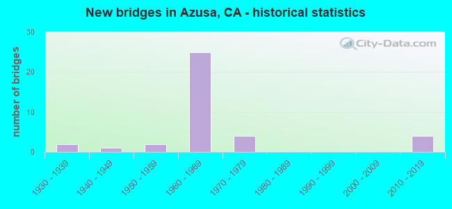
- New bridges - historical statistics
- 21930-1939
- 11940-1949
- 21950-1959
- 251960-1969
- 41970-1979
- 42010-2019


- Bridge Condition - Deck
- 40.0%Good
- 5.0%Satisfactory
- 50.0%Fair
- 5.0%Poor

- Bridge Condition - Superstructure
- 4.5%Very good
- 50.0%Good
- 4.5%Satisfactory
- 40.9%Fair

- Bridge Condition - Substructure
- 4.5%Very good
- 86.4%Good
- 9.1%Satisfactory

- Bridge Condition - Channel
- 57.1%Excellent
- 28.6%Very good
- 14.3%Good

- Bridge Condition - Culverts
- 50.0%Very good
- 50.0%Good
Find on map >> Show street view
Structure Number: 53 0113, Location: 07-LA-039-17.82 (Lat: 34.164042, Lng: -117.894964), Route carried "on" structure: State highway 39, Year Built: 1933, Status: Open, Structure Length: 10.84m (35.56ft), Average Daily Traffic: 2,350 (year 2017), Truck Traffic: 4%, Average Future Daily Traffic: 7,358 (year 2041), Design Load: H 20, Features Intersected: SAN GABRIEL RIVER
Minimum Vertical Clearance: 30+ m (98+ ft), Kilometerpoint: 17.820, Lanes on structure: 2, Base Highway Network: Yes (, Subroute: 1), Owner: State Highway Agency, Approaching Roadway Width: 10.7m (35.1ft), Material/Design: Steel, Design/Construction: Truss - Deck, Number Of Spans In Main Unit: 2, Number Of Approach Spans: 1, Length of Maximum Span: 46.5m (152.6ft), Curb or Sidewalk Widths: Left: 0.2m (0.7ft), Right: 0.2m (0.7ft), Curb-To-Curb Width: 10.4m (34.1ft), Out-to-Out Width: 11.4m (37.4ft)
Condition: Deck: Fair, Superstructure: Good, Substructure: Good, Channel: Good, Operating Rating: 35.3 metric tons, Method Used To Determine Operating Rating: Load Factor (LF), Inventory Rating: 21.1 metric tons, Method Used To Determine Inventory Rating: Load Factor (LF), Structural Evaluation: Somewhat better than minimum adequacy, Deck Geometry: Somewhat better than minimum adequacy, Waterway Adequacy: Equal to present desirable criteria, Approach Roadway Alignment: Superior to present desirable criteria, Designated Inspection Frequency: Every 24 months, Critical Feature Inspection Frequency: Every 24 months, Inspection Date: September 2020, Critical Feature Inspection Date: June 2020, Deck Structure Type: Concrete Cast-file-Place
Find on map >> Show street view
Structure Number: 53 0114, Location: 07-LA-039-18.36 (Lat: 34.169458, Lng: -117.892403), Route carried "on" structure: State highway 39, Year Built: 1934, Status: Open, Structure Length: 2.14m (7.02ft), Average Daily Traffic: 2,350 (year 2017), Truck Traffic: 4%, Average Future Daily Traffic: 7,358 (year 2041), Design Load: H 20, Features Intersected: CHAPMAN CANYON
Minimum Vertical Clearance: 30+ m (98+ ft), Kilometerpoint: 18.360, Lanes on structure: 2, Base Highway Network: Yes (, Subroute: 5), Owner: State Highway Agency, Approaching Roadway Width: 10.7m (35.1ft), Material/Design: Concrete, Design/Construction: Tee Beam, Number Of Spans In Main Unit: 3, Length of Maximum Span: 9.1m (29.9ft), Curb or Sidewalk Widths: Left: 0.2m (0.7ft), Right: 0.2m (0.7ft), Curb-To-Curb Width: 10.4m (34.1ft), Out-to-Out Width: 11.4m (37.4ft)
Condition: Deck: Good, Superstructure: Good, Substructure: Good, Channel: Good, Operating Rating: 30.5 metric tons, Method Used To Determine Operating Rating: Load and Resistance Factor Rating (LRFR) rating reported by rating factor(RF) method using HL-93 loadings, Inventory Rating: 23.7 metric tons, Method Used To Determine Inventory Rating: Load and Resistance Factor Rating (LRFR) rating reported by rating factor(RF) method using HL-93 loadings, Structural Evaluation: Equal to present minimum criteria, Deck Geometry: Somewhat better than minimum adequacy, Waterway Adequacy: Better than present minimum criteria, Approach Roadway Alignment: Equal to present desirable criteria, Designated Inspection Frequency: Every 24 months, Inspection Date: September 2020, Deck Structure Type: Concrete Cast-file-Place, Wearing Surface/Protective System: Wearing Surface: Bituminous
Find on map >> Show street view
Structure Number: 53 1871M, Location: 07-LA-005-R55.28 (Lat: 34.437531, Lng: -118.595281), Route carried "on" structure: Interstate 5, Year Built: 1964, Status: Open, Structure Length: 1.10m (3.61ft), Average Daily Traffic: 134,090 (year 2011), Truck Traffic: 16%, Average Future Daily Traffic: 202,800 (year 2038), Design Load: HS 20, Features Intersected: NEWHALL RANCH DRAIN
Minimum Vertical Clearance: 30+ m (98+ ft), Kilometerpoint: 55.280, Lanes on structure: 9, Base Highway Network: Yes (, Subroute: 1), Owner: State Highway Agency, Approaching Roadway Width: 52.4m (171.9ft), Skew: 4 degrees, Material/Design: Concrete continuous, Design/Construction: Culvert, Number Of Spans In Main Unit: 2, Length of Maximum Span: 5.5m (18.0ft), Curb-To-Curb Width: 52.4m (171.9ft), Out-to-Out Width: 67.0m (219.8ft)
Condition: Channel: Very good, Culverts: Good, Operating Rating: 54.1 metric tons, Method Used To Determine Operating Rating: Field evaluation and documented engineering judgment, Inventory Rating: 32.4 metric tons, Method Used To Determine Inventory Rating: Field evaluation and documented engineering judgment, Structural Evaluation: Better than present minimum criteria, Deck Geometry: Superior to present desirable criteria, Waterway Adequacy: Equal to present desirable criteria, Approach Roadway Alignment: Equal to present desirable criteria, Designated Inspection Frequency: Every 24 months, Inspection Date: April 2021
Find on map >> Show street view
Structure Number: 53 1879, Location: 07-LA-210-R38.58-AZU (Lat: 34.128983, Lng: -117.921831), Route carried "on" structure: City street , Year Built: 1968, Status: Open, Structure Length: 7.16m (23.49ft), Average Daily Traffic: 1,500 (year 2015), Truck Traffic: 1%, Average Future Daily Traffic: 2,162 (year 2042), Design Load: HS 20, Features Intersected: ROUTE 210, Facility Carried by Structure: ZACHARY PADILLA AV
Minimum Vertical Clearance: 30+ m (98+ ft), Kilometerpoint: 0.000, Lanes on structure: 2, Lanes under structure: 10, Owner: State Highway Agency, Approaching Roadway Width: 12.2m (40.0ft), Skew: 1 degrees, Material/Design: Concrete continuous, Design/Construction: Box Beam or Girders - Multiple, Number Of Spans In Main Unit: 2, Length of Maximum Span: 35.7m (117.1ft), Curb or Sidewalk Widths: Left: 1.5m (4.9ft), Right: 1.5m (4.9ft), Curb-To-Curb Width: 12.2m (40.0ft), Out-to-Out Width: 15.8m (51.8ft)
Condition: Deck: Good, Superstructure: Fair, Substructure: Good, Operating Rating: 62.9 metric tons, Method Used To Determine Operating Rating: Load and Resistance Factor Rating (LRFR) rating reported by rating factor(RF) method using HL-93 loadings, Inventory Rating: 48.6 metric tons, Method Used To Determine Inventory Rating: Load and Resistance Factor Rating (LRFR) rating reported by rating factor(RF) method using HL-93 loadings, Structural Evaluation: Somewhat better than minimum adequacy, Deck Geometry: Better than present minimum criteria, Underclear: Meets minimum limits, Approach Roadway Alignment: Equal to present desirable criteria, Designated Inspection Frequency: Every 24 months, Inspection Date: March 2021, Deck Structure Type: Concrete Cast-file-Place
Find on map >> Show street view
Structure Number: 53 1886, Location: 07-LA-210-R39.58-AZU (Lat: 34.120419, Lng: -117.907864), Route carried "on" structure: Interstate 210, Year Built: 1968, Status: Open, Structure Length: 5.36m (17.59ft), Average Daily Traffic: 250,000 (year 2015), Average Future Daily Traffic: 231,417 (year 2042), Design Load: HS 20, Features Intersected: S AZUSA AVE
Minimum Vertical Clearance: 30+ m (98+ ft), Kilometerpoint: 39.580, Lanes on structure: 11, Lanes under structure: 6, Base Highway Network: Yes (Inventory Route: 2, Subroute: 1), Owner: State Highway Agency, Approaching Roadway Width: 49.4m (162.1ft), Skew: 30 degrees, Material/Design: Concrete continuous, Design/Construction: Box Beam or Girders - Multiple, Number Of Spans In Main Unit: 4, Length of Maximum Span: 15.5m (50.9ft), Curb-To-Curb Width: 48.5m (159.1ft), Out-to-Out Width: 49.7m (163.1ft)
Condition: Deck: Fair, Superstructure: Good, Substructure: Good, Operating Rating: 28.8 metric tons, Method Used To Determine Operating Rating: Load and Resistance Factor Rating (LRFR) rating reported by rating factor(RF) method using HL-93 loadings, Inventory Rating: 22.0 metric tons, Method Used To Determine Inventory Rating: Load and Resistance Factor Rating (LRFR) rating reported by rating factor(RF) method using HL-93 loadings, Structural Evaluation: Somewhat better than minimum adequacy, Deck Geometry: Superior to present desirable criteria, Underclear: Somewhat better than minimum adequacy, Approach Roadway Alignment: Equal to present desirable criteria, Designated Inspection Frequency: Every 24 months, Inspection Date: March 2021, Deck Structure Type: Concrete Cast-file-Place
Find on map >> Show street view
Structure Number: 53 1886S, Location: 07-LA-210-R39.58-AZU (Lat: 34.120247, Lng: -117.907844), Route carried "on" structure: Ramp Interstate 210, Year Built: 1968, Status: Open, Structure Length: 4.72m (15.49ft), Average Daily Traffic: 4,100 (year 2015), Truck Traffic: 2%, Average Future Daily Traffic: 7,482 (year 2042), Design Load: HS 20, Features Intersected: S AZUSA AVE
Minimum Vertical Clearance: 30+ m (98+ ft), Kilometerpoint: 39.580, Lanes on structure: 1, Lanes under structure: 6, Base Highway Network: Yes (, Subroute: 1), Owner: State Highway Agency, Approaching Roadway Width: 6.7m (22.0ft), Material/Design: Concrete continuous, Design/Construction: Box Beam or Girders - Multiple, Number Of Spans In Main Unit: 4, Length of Maximum Span: 15.8m (51.8ft), Curb-To-Curb Width: 6.7m (22.0ft), Out-to-Out Width: 7.9m (25.9ft)
Condition: Deck: Good, Superstructure: Good, Substructure: Good, Operating Rating: 48.0 metric tons, Method Used To Determine Operating Rating: Load and Resistance Factor Rating (LRFR) rating reported by rating factor(RF) method using HL-93 loadings, Inventory Rating: 34.7 metric tons, Method Used To Determine Inventory Rating: Load and Resistance Factor Rating (LRFR) rating reported by rating factor(RF) method using HL-93 loadings, Structural Evaluation: Better than present minimum criteria, Deck Geometry: Equal to present minimum criteria, Underclear: Somewhat better than minimum adequacy, Approach Roadway Alignment: Equal to present desirable criteria, Designated Inspection Frequency: Every 24 months, Inspection Date: March 2021, Deck Structure Type: Concrete Cast-file-Place
Find on map >> Show street view
Structure Number: 53 1887, Location: 07-LA-210-R38.96-AZU (Lat: 34.126728, Lng: -117.916011), Route carried "on" structure: City street , Year Built: 1968, Status: Open, Structure Length: 8.34m (27.36ft), Average Daily Traffic: 8,700 (year 2015), Truck Traffic: 2%, Average Future Daily Traffic: 12,362 (year 2042), Design Load: HS 20, Features Intersected: ROUTE 210, Facility Carried by Structure: VERNON AVENUE
Minimum Vertical Clearance: 30+ m (98+ ft), Kilometerpoint: 0.000, Lanes on structure: 6, Lanes under structure: 10, Owner: State Highway Agency, Approaching Roadway Width: 19.5m (64.0ft), Skew: 23 degrees, Material/Design: Prestressed concrete continuous, Design/Construction: Box Beam or Girders - Multiple, Number Of Spans In Main Unit: 2, Length of Maximum Span: 41.5m (136.2ft), Curb or Sidewalk Widths: Left: 1.5m (4.9ft), Right: 1.5m (4.9ft), Curb-To-Curb Width: 14.6m (47.9ft), Out-to-Out Width: 23.2m (76.1ft)
Condition: Deck: Good, Superstructure: Good, Substructure: Good, Operating Rating: 99.8 metric tons, Method Used To Determine Operating Rating: Load Factor (LF), Inventory Rating: 32.4 metric tons, Method Used To Determine Inventory Rating: Load Factor (LF), Structural Evaluation: Better than present minimum criteria, Deck Geometry: High priority of replacement, Underclear: Meets minimum limits, Approach Roadway Alignment: Superior to present desirable criteria, Designated Inspection Frequency: Every 24 months, Inspection Date: March 2021, Deck Structure Type: Concrete Cast-file-Place
Find on map >> Show street view
Structure Number: 53 1888, Location: 07-LA-210-R39.36-AZU (Lat: 34.121872, Lng: -117.911858), Route carried "on" structure: Interstate 210, Year Built: 1968, Year Reconstructed: 2004, Status: Open, Structure Length: 8.01m (26.28ft), Average Daily Traffic: 250,000 (year 2015), Average Future Daily Traffic: 231,417 (year 2042), Design Load: HS 20, Features Intersected: FIRST STREET
Minimum Vertical Clearance: 30+ m (98+ ft), Kilometerpoint: 39.360, Lanes on structure: 13, Lanes under structure: 2, Base Highway Network: Yes (Inventory Route: 2, Subroute: 1), Owner: State Highway Agency, Approaching Roadway Width: 54.3m (178.1ft), Skew: 35 degrees, Material/Design: Concrete continuous, Design/Construction: Box Beam or Girders - Multiple, Number Of Spans In Main Unit: 4, Length of Maximum Span: 21.3m (69.9ft), Curb-To-Curb Width: 53.6m (175.9ft), Out-to-Out Width: 57.1m (187.3ft)
Condition: Deck: Fair, Superstructure: Good, Substructure: Good, Operating Rating: 94.3 metric tons, Method Used To Determine Operating Rating: Load Factor (LF), Inventory Rating: 56.7 metric tons, Method Used To Determine Inventory Rating: Load Factor (LF), Structural Evaluation: Better than present minimum criteria, Deck Geometry: Equal to present minimum criteria, Underclear: Somewhat better than minimum adequacy, Approach Roadway Alignment: Equal to present desirable criteria, Designated Inspection Frequency: Every 24 months, Inspection Date: March 2021, Deck Structure Type: Concrete Cast-file-Place
Find on map >> Show street view
Structure Number: 53 2020K, Location: 07-LA-210-R29.81-ADA (Lat: 34.149139, Lng: -118.068156), Route carried "on" structure: Ramp Interstate 210, Year Built: 1971, Status: Open, Structure Length: 11.77m (38.62ft), Average Daily Traffic: 7,500 (year 2012), Truck Traffic: 2%, Average Future Daily Traffic: 12,800 (year 2042), Design Load: HS 20, Features Intersected: MICHILLINDA AVE & ONRAMP
Minimum Vertical Clearance: 30+ m (98+ ft), Kilometerpoint: 29.810, Lanes on structure: 3, Lanes under structure: 8, Owner: State Highway Agency, Approaching Roadway Width: 11.0m (36.1ft), Skew: 9 degrees, Material/Design: Concrete continuous, Design/Construction: Box Beam or Girders - Multiple, Number Of Spans In Main Unit: 4, Length of Maximum Span: 33.5m (109.9ft), Curb-To-Curb Width: 11.0m (36.1ft), Out-to-Out Width: 11.6m (38.1ft)
Condition: Deck: Fair, Superstructure: Fair, Substructure: Good, Operating Rating: 65.3 metric tons, Method Used To Determine Operating Rating: Load Factor (LF), Inventory Rating: 39.0 metric tons, Method Used To Determine Inventory Rating: Load Factor (LF), Structural Evaluation: Somewhat better than minimum adequacy, Deck Geometry: High priority of replacement, Underclear: Better than present minimum criteria, Approach Roadway Alignment: Better than present minimum criteria, Designated Inspection Frequency: Every 24 months, Inspection Date: May 2021, Deck Structure Type: Concrete Cast-file-Place
Find on map >> Show street view
Structure Number: 53 2023, Location: 07-LA-210-R40.07-AZU (Lat: 34.121414, Lng: -117.899528), Route carried "on" structure: City street , Year Built: 1969, Status: Open, Structure Length: 6.50m (21.33ft), Average Daily Traffic: 8,500 (year 2015), Truck Traffic: 2%, Average Future Daily Traffic: 10,302 (year 2042), Design Load: HS 20, Features Intersected: INTERSTATE 210, Facility Carried by Structure: CERRITOS AVENUE
Minimum Vertical Clearance: 30+ m (98+ ft), Kilometerpoint: 0.000, Lanes on structure: 5, Lanes under structure: 10, Owner: State Highway Agency, Approaching Roadway Width: 19.5m (64.0ft), Material/Design: Concrete continuous, Design/Construction: Box Beam or Girders - Multiple, Number Of Spans In Main Unit: 2, Length of Maximum Span: 33.2m (108.9ft), Curb or Sidewalk Widths: Left: 1.5m (4.9ft), Right: 1.5m (4.9ft), Curb-To-Curb Width: 19.5m (64.0ft), Out-to-Out Width: 23.2m (76.1ft)
Condition: Deck: Fair, Superstructure: Fair, Substructure: Good, Operating Rating: 54.1 metric tons, Method Used To Determine Operating Rating: Load and Resistance Factor Rating (LRFR) rating reported by rating factor(RF) method using HL-93 loadings, Inventory Rating: 38.6 metric tons, Method Used To Determine Inventory Rating: Load and Resistance Factor Rating (LRFR) rating reported by rating factor(RF) method using HL-93 loadings, Structural Evaluation: Somewhat better than minimum adequacy, Deck Geometry: Meets minimum limits, Underclear: Meets minimum limits, Approach Roadway Alignment: Superior to present desirable criteria, Designated Inspection Frequency: Every 24 months, Inspection Date: March 2021, Deck Structure Type: Concrete Cast-file-Place
Find on map >> Show street view
Structure Number: 53 2024, Location: 07-LA-210-R40.60-AZU (Lat: 34.121178, Lng: -117.890297), Route carried "on" structure: City street L532, Year Built: 1969, Status: Open, Structure Length: 7.07m (23.20ft), Average Daily Traffic: 21,000 (year 2015), Truck Traffic: 1%, Average Future Daily Traffic: 31,951 (year 2042), Design Load: HS 20, Features Intersected: INTERSTATE 210, Facility Carried by Structure: CITRUS AVENUE
Minimum Vertical Clearance: 30+ m (98+ ft), Kilometerpoint: 0.000, Lanes on structure: 5, Lanes under structure: 11, Owner: State Highway Agency, Approaching Roadway Width: 20.7m (67.9ft), Skew: 20 degrees, Material/Design: Concrete continuous, Design/Construction: Box Beam or Girders - Multiple, Number Of Spans In Main Unit: 2, Length of Maximum Span: 37.2m (122.0ft), Curb or Sidewalk Widths: Left: 1.5m (4.9ft), Right: 1.5m (4.9ft), Curb-To-Curb Width: 19.5m (64.0ft), Out-to-Out Width: 24.4m (80.1ft)
Condition: Deck: Fair, Superstructure: Fair, Substructure: Good, Operating Rating: 38.9 metric tons, Method Used To Determine Operating Rating: Load and Resistance Factor Rating (LRFR) rating reported by rating factor(RF) method using HL-93 loadings, Inventory Rating: 29.8 metric tons, Method Used To Determine Inventory Rating: Load and Resistance Factor Rating (LRFR) rating reported by rating factor(RF) method using HL-93 loadings, Structural Evaluation: Somewhat better than minimum adequacy, Deck Geometry: Meets minimum limits, Underclear: High priority of corrective action, Approach Roadway Alignment: Equal to present desirable criteria, Designated Inspection Frequency: Every 24 months, Inspection Date: March 2021, Deck Structure Type: Concrete Cast-file-Place
Find on map >> Show street view
Structure Number: 53 2059, Location: 07-LA-210-R39.80-AZU (Lat: 34.120567, Lng: -117.905267), Route carried "on" structure: Interstate 210, Year Built: 1969, Status: Open, Structure Length: 1.19m (3.90ft), Average Daily Traffic: 250,000 (year 2015), Average Future Daily Traffic: 231,417 (year 2042), Design Load: HS 20, Features Intersected: LITTLE DALTON WASH
Minimum Vertical Clearance: 30+ m (98+ ft), Kilometerpoint: 39.800, Lanes on structure: 12, Lanes under structure: 1, Base Highway Network: Yes (Inventory Route: 2, Subroute: 1), Owner: State Highway Agency, Approaching Roadway Width: 64.0m (210.0ft), Skew: 34 degrees, Material/Design: Concrete, Design/Construction: Box Beam or Girders - Single/Spread, Number Of Spans In Main Unit: 1, Length of Maximum Span: 11.6m (38.1ft), Curb-To-Curb Width: 64.0m (210.0ft), Out-to-Out Width: 113.7m (373.0ft)
Condition: Deck: Good, Superstructure: Good, Substructure: Good, Channel: Very good, Operating Rating: 54.1 metric tons, Method Used To Determine Operating Rating: Assigned rating based on Load Factor Design (LFD) reported in metric tons, Inventory Rating: 32.4 metric tons, Method Used To Determine Inventory Rating: Assigned rating based on Load Factor Design (LFD) reported in metric tons, Structural Evaluation: Better than present minimum criteria, Deck Geometry: Somewhat better than minimum adequacy, Waterway Adequacy: Equal to present desirable criteria, Approach Roadway Alignment: Superior to present desirable criteria, Designated Inspection Frequency: Every 24 months, Inspection Date: March 2021
Find on map >> Show street view
Structure Number: 53C0054, Location: 0.1MI W/O AZUSA AVE (Lat: 34.106617, Lng: -117.906289), Route carried "on" structure: County highway L528, Year Built: 1956, Status: Open, Structure Length: 3.38m (11.09ft), Average Daily Traffic: 12,059 (year 2014), Truck Traffic: 3%, Average Future Daily Traffic: 13,868 (year 2040), Design Load: HS 20, Features Intersected: BIG DALTON WASH, Facility Carried by Structure: ARROW HWY
Minimum Vertical Clearance: 30.47m (99.97ft), Kilometerpoint: 0.000, Lanes on structure: 4, Owner: City or Municipal Highway Agency, Approaching Roadway Width: 24.4m (80.1ft), Skew: 5 degrees, Material/Design: Steel, Design/Construction: Stringer/Multi-beam, Number Of Spans In Main Unit: 2, Length of Maximum Span: 15.8m (51.8ft), Curb or Sidewalk Widths: Left: 1.5m (4.9ft), Right: 1.6m (5.2ft), Curb-To-Curb Width: 20.1m (65.9ft), Out-to-Out Width: 23.8m (78.1ft)
Condition: Deck: Good, Superstructure: Fair, Substructure: Good, Channel: Excellent, Operating Rating: 47.3 metric tons, Method Used To Determine Operating Rating: Load Factor (LF), Inventory Rating: 28.2 metric tons, Method Used To Determine Inventory Rating: Load Factor (LF), Structural Evaluation: Somewhat better than minimum adequacy, Deck Geometry: Better than present minimum criteria, Waterway Adequacy: Superior to present desirable criteria, Approach Roadway Alignment: Equal to present desirable criteria, Designated Inspection Frequency: Every 24 months, Inspection Date: April 2020, Deck Structure Type: Concrete Cast-file-Place
Find on map >> Show street view
Structure Number: 53C0374, Location: 0.3MI NE/O I-10 FWY (Lat: 34.287975, Lng: -118.401644), Route carried "on" structure: County highway , Year Built: 1975, Status: Open, Structure Length: 2.19m (7.19ft), Average Daily Traffic: 10,479 (year 2012), Truck Traffic: 10%, Average Future Daily Traffic: 12,051 (year 2040), Design Load: HS 20+Mod, Features Intersected: LOPEZ CYN CHAN, Facility Carried by Structure: PAXTON ST
Minimum Vertical Clearance: 30.47m (99.97ft), Kilometerpoint: 0.000, Lanes on structure: 3, Owner: County Highway Agency, Approaching Roadway Width: 12.8m (42.0ft), Material/Design: Prestressed concrete, Design/Construction: Stringer/Multi-beam, Number Of Spans In Main Unit: 1, Length of Maximum Span: 21.6m (70.9ft), Curb or Sidewalk Widths: Left: 3.0m (9.8ft), Right: 3.0m (9.8ft), Curb-To-Curb Width: 20.1m (65.9ft), Out-to-Out Width: 26.8m (87.9ft)
Condition: Deck: Good, Superstructure: Very good, Substructure: Good, Channel: Excellent, Operating Rating: 55.4 metric tons, Method Used To Determine Operating Rating: Load Factor (LF), Inventory Rating: 36.0 metric tons, Method Used To Determine Inventory Rating: Load Factor (LF), Structural Evaluation: Better than present minimum criteria, Deck Geometry: Superior to present desirable criteria, Waterway Adequacy: Superior to present desirable criteria, Approach Roadway Alignment: Equal to present minimum criteria, Designated Inspection Frequency: Every 48 months, Inspection Date: August 2020, Deck Structure Type: Concrete Cast-file-Place, Wearing Surface/Protective System: Wearing Surface: Monolithic Concrete
Find on map >> Show street view
Structure Number: 53C0395, Location: 0.8MI E/O AZUSA AVE (Lat: 34.131061, Lng: -117.895092), Route carried "on" structure: City street L535, Year Built: 1960, Status: Open, Structure Length: 0.91m (2.99ft), Average Daily Traffic: 11,900 (year 2014), Truck Traffic: 3%, Average Future Daily Traffic: 13,590 (year 2040), Features Intersected: LITTLE DALTON WASH, Facility Carried by Structure: ALOSTA AVE
Minimum Vertical Clearance: 30.47m (99.97ft), Kilometerpoint: 0.000, Lanes on structure: 4, Owner: City or Municipal Highway Agency, Approaching Roadway Width: 18.7m (61.4ft), Skew: 22 degrees, Material/Design: Concrete, Design/Construction: Culvert, Number Of Spans In Main Unit: 1, Length of Maximum Span: 7.6m (24.9ft), Curb or Sidewalk Widths: Left: 2.1m (6.9ft), Right: 2.2m (7.2ft), Curb-To-Curb Width: 18.9m (62.0ft), Out-to-Out Width: 27.7m (90.9ft)
Condition: Channel: Excellent, Culverts: Very good, Operating Rating: 54.1 metric tons, Method Used To Determine Operating Rating: Field evaluation and documented engineering judgment, Inventory Rating: 32.4 metric tons, Method Used To Determine Inventory Rating: Field evaluation and documented engineering judgment, Structural Evaluation: Equal to present desirable criteria, Deck Geometry: Equal to present minimum criteria, Waterway Adequacy: Superior to present desirable criteria, Approach Roadway Alignment: Better than present minimum criteria, Designated Inspection Frequency: Every 48 months, Inspection Date: April 2020, Deck Structure Type: Concrete Cast-file-Place, Wearing Surface/Protective System: Wearing Surface: Bituminous
Find on map >> Show street view
Structure Number: 53C0705, Location: 0.3MI N/O ACOSTA AVE (Lat: 34.131686, Lng: -117.889969), Route carried "on" structure: City street L532, Year Built: 1961, Status: Open, Structure Length: 0.69m (2.26ft), Average Daily Traffic: 5,000 (year 2012), Truck Traffic: 1%, Average Future Daily Traffic: 5,500 (year 2040), Design Load: HS 20+Mod, Features Intersected: LITTLE DALTON WASH, Facility Carried by Structure: CITRUS AVE
Minimum Vertical Clearance: 30.47m (99.97ft), Kilometerpoint: 0.000, Lanes on structure: 4, Owner: City or Municipal Highway Agency, Approaching Roadway Width: 18.9m (62.0ft), Material/Design: Concrete, Design/Construction: Slab, Number Of Spans In Main Unit: 1, Length of Maximum Span: 6.4m (21.0ft), Curb or Sidewalk Widths: Left: 1.6m (5.2ft), Right: 1.6m (5.2ft), Curb-To-Curb Width: 18.3m (60.0ft), Out-to-Out Width: 22.0m (72.2ft)
Condition: Deck: Satisfactory, Superstructure: Good, Substructure: Good, Channel: Excellent, Operating Rating: 55.1 metric tons, Method Used To Determine Operating Rating: Load Factor (LF), Inventory Rating: 33.0 metric tons, Method Used To Determine Inventory Rating: Load Factor (LF), Structural Evaluation: Better than present minimum criteria, Deck Geometry: Somewhat better than minimum adequacy, Waterway Adequacy: Superior to present desirable criteria, Approach Roadway Alignment: Equal to present desirable criteria, Designated Inspection Frequency: Every 48 months, Inspection Date: April 2020, Deck Structure Type: Concrete Cast-file-Place, Wearing Surface/Protective System: Wearing Surface: Bituminous
Find on map >> Show street view
Structure Number: 53C1446, Location: 0.1MI S/O ALOSTA BLVD (Lat: 34.130664, Lng: -117.896164), Route carried "on" structure: City street QP38, Year Built: 1961, Status: Open, Structure Length: 0.92m (3.02ft), Average Daily Traffic: 1,273 (year 2012), Truck Traffic: 1%, Average Future Daily Traffic: 1,400 (year 2040), Design Load: HS 20, Features Intersected: LITTLE DALTON WASH, Facility Carried by Structure: ROCKVALE AVE
Minimum Vertical Clearance: 30.47m (99.97ft), Kilometerpoint: 0.000, Lanes on structure: 2, Owner: City or Municipal Highway Agency, Approaching Roadway Width: 12.2m (40.0ft), Skew: 2 degrees, Material/Design: Concrete, Design/Construction: Slab, Number Of Spans In Main Unit: 1, Length of Maximum Span: 8.2m (26.9ft), Curb or Sidewalk Widths: Left: 1.8m (5.9ft), Right: 1.7m (5.6ft), Curb-To-Curb Width: 12.2m (40.0ft), Out-to-Out Width: 16.0m (52.5ft)
Condition: Deck: Fair, Superstructure: Fair, Substructure: Satisfactory, Channel: Very good, Operating Rating: 46.3 metric tons, Method Used To Determine Operating Rating: Load Factor (LF), Inventory Rating: 27.9 metric tons, Method Used To Determine Inventory Rating: Load Factor (LF), Structural Evaluation: Somewhat better than minimum adequacy, Deck Geometry: Better than present minimum criteria, Waterway Adequacy: Superior to present desirable criteria, Approach Roadway Alignment: Equal to present desirable criteria, Designated Inspection Frequency: Every 24 months, Inspection Date: April 2020, Deck Structure Type: Concrete Cast-file-Place
Find on map >> Show street view
Structure Number: 53C1455, Location: 0.2MI N/O ARROW HWY (Lat: 34.108197, Lng: -117.898847), Route carried "on" structure: City street Q923, Year Built: 1961, Status: Open, Structure Length: 1.04m (3.41ft), Average Daily Traffic: 6,302 (year 2012), Truck Traffic: 4%, Average Future Daily Traffic: 7,248 (year 2040), Features Intersected: BIG DALTON WASH, Facility Carried by Structure: CERRITOS AVE
Minimum Vertical Clearance: 30.47m (99.97ft), Kilometerpoint: 0.000, Lanes on structure: 4, Owner: City or Municipal Highway Agency, Approaching Roadway Width: 19.5m (64.0ft), Material/Design: Steel, Design/Construction: Stringer/Multi-beam, Number Of Spans In Main Unit: 1, Length of Maximum Span: 9.4m (30.8ft), Curb or Sidewalk Widths: Left: 1.3m (4.3ft), Right: 1.3m (4.3ft), Curb-To-Curb Width: 19.4m (63.6ft), Out-to-Out Width: 22.5m (73.8ft)
Condition: Deck: Good, Superstructure: Fair, Substructure: Good, Channel: Excellent, Operating Rating: 53.8 metric tons, Method Used To Determine Operating Rating: Load Factor (LF), Inventory Rating: 32.1 metric tons, Method Used To Determine Inventory Rating: Load Factor (LF), Structural Evaluation: Somewhat better than minimum adequacy, Deck Geometry: Better than present minimum criteria, Waterway Adequacy: Superior to present desirable criteria, Approach Roadway Alignment: Better than present minimum criteria, Designated Inspection Frequency: Every 24 months, Inspection Date: April 2020, Deck Structure Type: Concrete Cast-file-Place
Find on map >> Show street view
Structure Number: 53C1567, Location: 0.5MI E/O AZUSA AVE (Lat: 34.129739, Lng: -117.898411), Route carried "on" structure: City street QP33, Year Built: 1960, Status: Open, Structure Length: 1.37m (4.49ft), Average Daily Traffic: 1,273 (year 2012), Truck Traffic: 1%, Average Future Daily Traffic: 1,400 (year 2040), Features Intersected: LITTLE DALTON WASH, Facility Carried by Structure: FIFTH ST
Minimum Vertical Clearance: 30.47m (99.97ft), Kilometerpoint: 0.000, Lanes on structure: 2, Owner: City or Municipal Highway Agency, Approaching Roadway Width: 14.6m (47.9ft), Skew: 3 degrees, Material/Design: Concrete, Design/Construction: Slab, Number Of Spans In Main Unit: 1, Length of Maximum Span: 7.6m (24.9ft), Curb or Sidewalk Widths: Left: 1.7m (5.6ft), Right: 1.7m (5.6ft), Curb-To-Curb Width: 14.7m (48.2ft), Out-to-Out Width: 18.5m (60.7ft)
Condition: Deck: Fair, Superstructure: Fair, Substructure: Good, Channel: Excellent, Operating Rating: 41.1 metric tons, Method Used To Determine Operating Rating: Load Factor (LF), Inventory Rating: 24.6 metric tons, Method Used To Determine Inventory Rating: Load Factor (LF), Structural Evaluation: Somewhat better than minimum adequacy, Deck Geometry: Superior to present desirable criteria, Waterway Adequacy: Superior to present desirable criteria, Approach Roadway Alignment: Equal to present desirable criteria, Designated Inspection Frequency: Every 24 months, Inspection Date: April 2020, Deck Structure Type: Concrete Cast-file-Place
Find on map >> Show street view
Structure Number: 53C1568, Location: 0.3MI E/O AZUSA AVE (Lat: 34.121503, Lng: -117.904144), Route carried "on" structure: City street R060, Year Built: 1970, Status: Open, Structure Length: 1.43m (4.69ft), Average Daily Traffic: 2,550 (year 2016), Truck Traffic: 3%, Average Future Daily Traffic: 2,800 (year 2040), Features Intersected: LITTLE DALTON WASH, Facility Carried by Structure: FIRST ST
Minimum Vertical Clearance: 30.47m (99.97ft), Kilometerpoint: 0.000, Lanes on structure: 3, Owner: City or Municipal Highway Agency, Approaching Roadway Width: 19.4m (63.6ft), Skew: 4 degrees, Material/Design: Steel, Design/Construction: Stringer/Multi-beam, Number Of Spans In Main Unit: 1, Length of Maximum Span: 12.2m (40.0ft), Curb or Sidewalk Widths: Left: 2.3m (7.5ft), Right: 2.0m (6.6ft), Curb-To-Curb Width: 19.5m (64.0ft), Out-to-Out Width: 24.3m (79.7ft)
Condition: Deck: Fair, Superstructure: Fair, Substructure: Good, Channel: Excellent, Operating Rating: 48.0 metric tons, Method Used To Determine Operating Rating: Load Factor (LF), Inventory Rating: 28.8 metric tons, Method Used To Determine Inventory Rating: Load Factor (LF), Structural Evaluation: Somewhat better than minimum adequacy, Deck Geometry: Superior to present desirable criteria, Waterway Adequacy: Superior to present desirable criteria, Approach Roadway Alignment: Equal to present desirable criteria, Designated Inspection Frequency: Every 24 months, Inspection Date: March 2020, Deck Structure Type: Concrete Cast-file-Place, Wearing Surface/Protective System: Wearing Surface: Bituminous
Find on map >> Show street view
Structure Number: 53C1569, Location: 0.4MI S/O FOOTHILL BLVD (Lat: 34.128983, Lng: -117.899236), Route carried "on" structure: City street Q923, Year Built: 1960, Status: Open, Structure Length: 1.34m (4.40ft), Average Daily Traffic: 2,140 (year 2016), Truck Traffic: 1%, Average Future Daily Traffic: 22,350 (year 2040), Features Intersected: LITTLE DALTON WASH, Facility Carried by Structure: CERRITOS AVE
Minimum Vertical Clearance: 30.47m (99.97ft), Kilometerpoint: 0.000, Lanes on structure: 2, Owner: City or Municipal Highway Agency, Approaching Roadway Width: 16.9m (55.4ft), Skew: 5 degrees, Material/Design: Concrete, Design/Construction: Slab, Number Of Spans In Main Unit: 1, Length of Maximum Span: 12.8m (42.0ft), Curb or Sidewalk Widths: Left: 1.7m (5.6ft), Right: 1.7m (5.6ft), Curb-To-Curb Width: 19.9m (65.3ft), Out-to-Out Width: 23.4m (76.8ft)
Condition: Deck: Fair, Superstructure: Satisfactory, Substructure: Satisfactory, Channel: Excellent, Operating Rating: 40.8 metric tons, Method Used To Determine Operating Rating: Load Factor (LF), Inventory Rating: 24.6 metric tons, Method Used To Determine Inventory Rating: Load Factor (LF), Structural Evaluation: Equal to present minimum criteria, Deck Geometry: Superior to present desirable criteria, Waterway Adequacy: Superior to present desirable criteria, Approach Roadway Alignment: Somewhat better than minimum adequacy, Designated Inspection Frequency: Every 24 months, Inspection Date: April 2020, Deck Structure Type: Concrete Cast-file-Place
Find on map >> Show street view
Structure Number: 53C2186, Location: 0.3MI N/O GLADSTONE ST (Lat: 34.117022, Lng: -117.907494), Route carried "on" structure: City street , Year Built: 1959, Status: Open, Structure Length: 1.56m (5.12ft), Average Daily Traffic: 13,433 (year 2012), Truck Traffic: 4%, Average Future Daily Traffic: 15,448 (year 2040), Features Intersected: LITTLE DALTON WASH, Facility Carried by Structure: AZUSA AVE
Minimum Vertical Clearance: 30.47m (99.97ft), Kilometerpoint: 13.789, Lanes on structure: 4, Owner: City or Municipal Highway Agency, Approaching Roadway Width: 21.6m (70.9ft), Skew: 25 degrees, Material/Design: Concrete, Design/Construction: Tee Beam, Number Of Spans In Main Unit: 1, Length of Maximum Span: 15.1m (49.5ft), Curb or Sidewalk Widths: Left: 1.9m (6.2ft), Right: 1.9m (6.2ft), Curb-To-Curb Width: 20.8m (68.2ft), Out-to-Out Width: 30.3m (99.4ft)
Condition: Deck: Poor, Superstructure: Good, Substructure: Very good, Channel: Very good, Operating Rating: 54.1 metric tons, Method Used To Determine Operating Rating: Field evaluation and documented engineering judgment, Inventory Rating: 32.4 metric tons, Method Used To Determine Inventory Rating: Field evaluation and documented engineering judgment, Structural Evaluation: Better than present minimum criteria, Deck Geometry: Superior to present desirable criteria, Waterway Adequacy: Equal to present desirable criteria, Approach Roadway Alignment: Superior to present desirable criteria, Designated Inspection Frequency: Every 24 months, Inspection Date: May 2020, Deck Structure Type: Concrete Cast-file-Place
Find on map >> Show street view
Structure Number: 53C2214, Location: 0.8MI E/O N AZUSA AVE (Lat: 34.145147, Lng: -117.894300), Route carried "on" structure: City street , Year Built: 2012, Status: Open, Structure Length: 0.62m (2.03ft), Average Daily Traffic: 9,384 (year 2014), Truck Traffic: 1%, Average Future Daily Traffic: 10,792 (year 2040), Features Intersected: ROSEDALE PUC, Facility Carried by Structure: SIERRA MADRE AVE
Minimum Vertical Clearance: 30.47m (99.97ft), Kilometerpoint: 0.000, Lanes on structure: 3, Owner: City or Municipal Highway Agency, Approaching Roadway Width: 10.3m (33.8ft), Material/Design: Steel, Design/Construction: Arch - Deck, Number Of Spans In Main Unit: 1, Length of Maximum Span: 6.2m (20.3ft), Curb or Sidewalk Widths: Left: 1.9m (6.2ft), Right: 4.6m (15.1ft), Curb-To-Curb Width: 10.3m (33.8ft), Out-to-Out Width: 17.3m (56.8ft)
Condition: Superstructure: Good, Substructure: Good, Operating Rating: 54.1 metric tons, Method Used To Determine Operating Rating: Field evaluation and documented engineering judgment, Inventory Rating: 32.4 metric tons, Method Used To Determine Inventory Rating: Field evaluation and documented engineering judgment, Structural Evaluation: Better than present minimum criteria, Deck Geometry: High priority of replacement, Approach Roadway Alignment: Equal to present desirable criteria, Designated Inspection Frequency: Every 48 months, Inspection Date: April 2020
Find on map >> Show street view
Structure Number: 53C2314, Location: 0.7MI E/O SAN GBRL CYN RD (Lat: 34.236964, Lng: -117.840200), Route carried "on" structure: County highway , Year Built: 1973, Status: Open, Structure Length: 1.21m (3.97ft), Average Daily Traffic: 900 (year 2012), Average Future Daily Traffic: 990 (year 2039), Features Intersected: BURRO CYN, Facility Carried by Structure: E FRK RD
Minimum Vertical Clearance: 30.47m (99.97ft), Kilometerpoint: 0.000, Lanes on structure: 2, Owner: County Highway Agency, Approaching Roadway Width: 7.3m (24.0ft), Skew: 1 degrees, Material/Design: Steel, Design/Construction: Arch - Deck, Number Of Spans In Main Unit: 1, Length of Maximum Span: 9.4m (30.8ft), Curb-To-Curb Width: 11.1m (36.4ft), Out-to-Out Width: 12.0m (39.4ft)
Condition: Superstructure: Good, Substructure: Good, Operating Rating: 54.1 metric tons, Method Used To Determine Operating Rating: Field evaluation and documented engineering judgment, Inventory Rating: 32.4 metric tons, Method Used To Determine Inventory Rating: Field evaluation and documented engineering judgment, Structural Evaluation: Better than present minimum criteria, Deck Geometry: Better than present minimum criteria, Approach Roadway Alignment: Better than present minimum criteria, Designated Inspection Frequency: Every 24 months, Inspection Date: October 2021
Find on map >> Show street view
Structure Number: 53 1876, Location: 07-LA-210-R38.35-AZU (Lat: 34.130261, Lng: -117.924956), Route carried "under" structure: Interstate 210, Year Built: 1968, Structure Length: 0. m, Average Daily Traffic: 250,000 (year 2015), Features Intersected: INTERSTATE 210, Facility Carried by Structure: LACMTA & BNSF RY
Minimum Vertical Clearance: 5.26m (17.26ft), Kilometerpoint: 38.350, Lanes under structure: 10, Material/Design: Steel, Design/Construction: Stringer/Multi-beam, Length of Maximum Span: 32.9m (107.9ft)
Find on map >> Show street view
Structure Number: 53 1879, Location: 07-LA-210-R38.58-AZU (Lat: 34.128983, Lng: -117.921831), Route carried "under" structure: Interstate 210, Year Built: 1968, Structure Length: 0. m, Average Daily Traffic: 250,000 (year 2015), Features Intersected: ROUTE 210, Facility Carried by Structure: ZACHARY PADILLA AV
Minimum Vertical Clearance: 5.54m (18.18ft), Kilometerpoint: 38.580, Lanes on structure: 2, Lanes under structure: 10, Material/Design: Concrete continuous, Design/Construction: Box Beam or Girders - Multiple, Length of Maximum Span: 35.7m (117.1ft)
Find on map >> Show street view
Structure Number: 53 1886, Location: 07-LA-210-R39.58-AZU (Lat: 34.120419, Lng: -117.907864), Route carried "under" structure: City street , Year Built: 1968, Structure Length: 0. m, Average Daily Traffic: 23,500 (year 2015), Truck Traffic: 4%, Features Intersected: S AZUSA AVE, Facility Carried by Structure: INTERSTATE 210
Minimum Vertical Clearance: 4.93m (16.17ft), Kilometerpoint: 0.000, Lanes on structure: 11, Lanes under structure: 6, Material/Design: Concrete continuous, Design/Construction: Box Beam or Girders - Multiple, Length of Maximum Span: 15.5m (50.9ft)
Find on map >> Show street view
Structure Number: 53 1886S, Location: 07-LA-210-R39.58-AZU (Lat: 34.120247, Lng: -117.907844), Route carried "under" structure: City street , Year Built: 1968, Structure Length: 0. m, Average Daily Traffic: 23,500 (year 2015), Truck Traffic: 2%, Features Intersected: S AZUSA AVE, Facility Carried by Structure: AZUSA-E210 ON RAMP
Minimum Vertical Clearance: 4.93m (16.17ft), Kilometerpoint: 0.000, Lanes on structure: 1, Lanes under structure: 6, Material/Design: Concrete continuous, Design/Construction: Box Beam or Girders - Multiple, Length of Maximum Span: 15.8m (51.8ft)
Find on map >> Show street view
Structure Number: 53 1887, Location: 07-LA-210-R38.96-AZU (Lat: 34.126728, Lng: -117.916011), Route carried "under" structure: Interstate 210, Year Built: 1968, Structure Length: 0. m, Average Daily Traffic: 250,000 (year 2015), Features Intersected: ROUTE 210, Facility Carried by Structure: VERNON AVENUE
Minimum Vertical Clearance: 5.54m (18.18ft), Kilometerpoint: 38.960, Lanes on structure: 6, Lanes under structure: 10, Material/Design: Prestressed concrete continuous, Design/Construction: Box Beam or Girders - Multiple, Length of Maximum Span: 41.5m (136.2ft)
Find on map >> Show street view
Structure Number: 53 19, Location: 07-LA-210-R39.12-AZU (Lat: 34.124567, Lng: -117.913758), Route carried "under" structure: Interstate 210, Year Built: 1968, Structure Length: 0. m, Average Daily Traffic: 250,000 (year 2009), Features Intersected: INTERSTATE 210, Facility Carried by Structure: PEDESTRIAN WALKWAY
Minimum Vertical Clearance: 5.82m (19.09ft), Kilometerpoint: 39.120, Lanes under structure: 13, Material/Design: Concrete continuous, Design/Construction: Box Beam or Girders - Multiple, Length of Maximum Span: 32.0m (105.0ft)
Find on map >> Show street view
Structure Number: 53 2012, Location: 07-LA-210-R40.25-AZU (Lat: 34.121436, Lng: -117.896394), Route carried "under" structure: Interstate 210, Year Built: 1969, Structure Length: 0. m, Average Daily Traffic: 250,000 (year 2009), Features Intersected: INTERSTATE 210, Facility Carried by Structure: ROCKVALE AVE POC
Minimum Vertical Clearance: 5.92m (19.42ft), Kilometerpoint: 40.250, Lanes under structure: 11, Material/Design: Prestressed concrete continuous, Design/Construction: Box Beam or Girders - Multiple, Length of Maximum Span: 39.3m (128.9ft)
Find on map >> Show street view
Structure Number: 53 2023, Location: 07-LA-210-R40.07-AZU (Lat: 34.121414, Lng: -117.899528), Route carried "under" structure: Interstate 210, Year Built: 1969, Structure Length: 0. m, Average Daily Traffic: 250,000 (year 2015), Features Intersected: INTERSTATE 210, Facility Carried by Structure: CERRITOS AVENUE
Minimum Vertical Clearance: 4.95m (16.24ft), Kilometerpoint: 40.070, Lanes on structure: 5, Lanes under structure: 10, Material/Design: Concrete continuous, Design/Construction: Box Beam or Girders - Multiple, Length of Maximum Span: 33.2m (108.9ft)
Find on map >> Show street view
Structure Number: 53 2024, Location: 07-LA-210-R40.60-AZU (Lat: 34.121178, Lng: -117.890297), Route carried "under" structure: Interstate 210, Year Built: 1969, Structure Length: 0. m, Average Daily Traffic: 250,000 (year 2015), Features Intersected: INTERSTATE 210, Facility Carried by Structure: CITRUS AVENUE
Minimum Vertical Clearance: 5.36m (17.59ft), Kilometerpoint: 40.600, Lanes on structure: 5, Lanes under structure: 11, Material/Design: Concrete continuous, Design/Construction: Box Beam or Girders - Multiple, Length of Maximum Span: 37.2m (122.0ft)
Find on map >> Show street view
Structure Number: 53 205, Location: 07-LA-210-R40.92-AZU (Lat: 34.121325, Lng: -117.884683), Route carried "under" structure: Interstate 210, Year Built: 1969, Structure Length: 0. m, Average Daily Traffic: 250,000 (year 2009), Features Intersected: INTERSTATE 210, Facility Carried by Structure: GALANTO AVE POC
Minimum Vertical Clearance: 5.97m (19.59ft), Kilometerpoint: 40.920, Lanes under structure: 12, Material/Design: Prestressed concrete continuous, Design/Construction: Box Beam or Girders - Multiple, Length of Maximum Span: 41.1m (134.8ft)
Find on map >> Show street view
Structure Number: 53C0377, Location: 0.3MI W/O AZUSA AVE (Lat: 34.133444, Lng: -117.914133), Route carried "under" structure: City street L493, Year Built: 1941, Structure Length: 0. m, Average Daily Traffic: 15,554 (year 2012), Truck Traffic: 2%, Features Intersected: FOOTHILL BLVD, Facility Carried by Structure: METRO NB
Minimum Vertical Clearance: 4.42m (14.50ft), Kilometerpoint: 0.000, Lanes under structure: 4, Material/Design: Steel, Design/Construction: Girder and Floorbeam System, Length of Maximum Span: 39.9m (130.9ft)
Find on map >> Show street view
Structure Number: 53C236, Location: 07-LA-187-7.76-CLC (Lat: 34.028111, Lng: -118.391153), Route carried "under" structure: Alternate State highway 187, Year Built: 2014, Structure Length: 0. m, Average Daily Traffic: 42,250 (year 2012), Truck Traffic: 3%, Features Intersected: SR 187/VENICE BLVD, Facility Carried by Structure: LT RAIL EXPO LINE
Minimum Vertical Clearance: 4.85m (15.91ft), Kilometerpoint: 7.760, Lanes under structure: 8, Material/Design: Prestressed concrete continuous, Design/Construction: Box Beam or Girders - Single/Spread, Length of Maximum Span: 44.7m (146.7ft)
Find on map >> Show street view
Structure Number: 53C2367, Location: 0.37 MI W/O AZUSA AVE (Lat: 34.133583, Lng: -117.913528), Route carried "under" structure: City street , Year Built: 2014, Structure Length: 0. m, Average Daily Traffic: 15,600 (year 2012), Truck Traffic: 2%, Features Intersected: FOOTHILL BLVD, Facility Carried by Structure: METRO GOLD LINE S
Minimum Vertical Clearance: 4.57m (14.99ft), Kilometerpoint: 0.000, Lanes under structure: 4, Material/Design: Steel continuous, Design/Construction: Girder and Floorbeam System, Length of Maximum Span: 40.2m (131.9ft)
Find on map >> Show street view
Structure Number: 53C2368, Location: 0.37 MI W/O AZUSA AVE (Lat: 34.133583, Lng: -117.914056), Route carried "under" structure: City street , Year Built: 2014, Structure Length: 0. m, Average Daily Traffic: 15,600 (year 2012), Truck Traffic: 2%, Features Intersected: FOOTHILL BLVD, Facility Carried by Structure: METRO GOLD LINE N
Minimum Vertical Clearance: 4.57m (14.99ft), Kilometerpoint: 0.000, Lanes under structure: 4, Material/Design: Steel continuous, Design/Construction: Girder and Floorbeam System, Length of Maximum Span: 40.3m (132.2ft)