Bridge Statistics for Avenal, California (CA)
Condition, Traffic, Stress, Structural Evaluation, Project Costs
- National Bridge Inventory (NBI) Statistics
- 10Number of bridges
- 141ft / 43.0mTotal length
- 104,765Total average daily traffic
- 32,672Total average daily truck traffic
- National Bridge Inventory (NBI) Registered Bridges for Avenal
- No street view available for this location
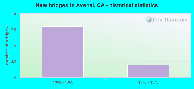
- New bridges - historical statistics
- 81960-1969
- 21970-1979


- Bridge Condition - Deck
- 85.7%Good
- 14.3%Fair

- Bridge Condition - Superstructure
- 14.3%Very good
- 71.4%Good
- 14.3%Fair

- Bridge Condition - Substructure
- 14.3%Very good
- 71.4%Good
- 14.3%Fair
Find on map >> Show street view
Structure Number: 45C0071, Location: 2.7 MI NE OF I-5 (Lat: 36.100036, Lng: -120.059500), Route carried "on" structure: County highway , Year Built: 1968, Status: Open, Structure Length: 5.76m (18.90ft), Average Daily Traffic: 1,000 (year 2017), Truck Traffic: 15%, Average Future Daily Traffic: 1,200 (year 2037), Design Load: HS 20, Features Intersected: San Luis Canal, Facility Carried by Structure: Avenal Cutoff Road
Minimum Vertical Clearance: 30+ m (98+ ft), Kilometerpoint: 264.520, Lanes on structure: 2, Owner: Bureau of Reclamation, Maintenance Responsibility: State Agenciy, Approaching Roadway Width: 9.9m (32.5ft), Material/Design: Prestressed concrete, Design/Construction: Stringer/Multi-beam, Number Of Spans In Main Unit: 2, Length of Maximum Span: 28.0m (91.9ft), Curb-To-Curb Width: 9.9m (32.5ft), Out-to-Out Width: 9.9m (32.5ft)
Condition: Deck: Good, Superstructure: Good, Substructure: Good, Channel: Excellent, Operating Rating: 43.7 metric tons, Method Used To Determine Operating Rating: Load and Resistance Factor Rating (LRFR) rating reported by rating factor(RF) method using HL-93 loadings, Inventory Rating: 33.7 metric tons, Method Used To Determine Inventory Rating: Load and Resistance Factor Rating (LRFR) rating reported by rating factor(RF) method using HL-93 loadings, Structural Evaluation: Better than present minimum criteria, Deck Geometry: Equal to present minimum criteria, Waterway Adequacy: Superior to present desirable criteria, Approach Roadway Alignment: Better than present minimum criteria, Designated Inspection Frequency: Every 48 months, Underwater Inspection Frequency: Every 60 months, Inspection Date: October 2018, Underwater Inspection Date: May 2018, Deck Structure Type: Concrete Cast-file-Place
Find on map >> Show street view
Structure Number: 45C0123, Location: 1.0 MI W 30TH AVE (Lat: 36.072461, Lng: -120.022689), Route carried "on" structure: County highway , Year Built: 1965, Status: Open, Structure Length: 5.92m (19.42ft), Average Daily Traffic: 200 (year 2017), Truck Traffic: 5%, Average Future Daily Traffic: 220 (year 2037), Design Load: HS 20, Features Intersected: San Luis Canal, Facility Carried by Structure: Plymouth Ave
Minimum Vertical Clearance: 30+ m (98+ ft), Kilometerpoint: 269.282, Lanes on structure: 2, Owner: Bureau of Reclamation, Maintenance Responsibility: State Agenciy, Approaching Roadway Width: 10.0m (32.8ft), Skew: 2 degrees, Material/Design: Prestressed concrete, Design/Construction: Stringer/Multi-beam, Number Of Spans In Main Unit: 2, Length of Maximum Span: 29.6m (97.1ft), Curb-To-Curb Width: 9.6m (31.5ft), Out-to-Out Width: 9.8m (32.2ft)
Condition: Deck: Good, Superstructure: Very good, Substructure: Very good, Channel: Excellent, Operating Rating: 99.0 metric tons, Method Used To Determine Operating Rating: Load Factor (LF), Inventory Rating: 32.4 metric tons, Method Used To Determine Inventory Rating: Load Factor (LF), Structural Evaluation: Equal to present desirable criteria, Deck Geometry: Equal to present minimum criteria, Waterway Adequacy: Equal to present desirable criteria, Approach Roadway Alignment: Equal to present desirable criteria, Designated Inspection Frequency: Every 48 months, Underwater Inspection Frequency: Every 60 months, Inspection Date: May 2020, Underwater Inspection Date: May 2018, Deck Structure Type: Concrete Cast-file-Place
Find on map >> Show street view
Structure Number: 42 023, Location: 06-FRE-269-0.40 (Lat: 36.076397, Lng: -120.101967), Route carried "on" structure: State highway 269, Year Built: 1967, Year Reconstructed: 2004, Status: Open, Structure Length: 9.05m (29.69ft), Average Daily Traffic: 4,650 (year 2009), Truck Traffic: 15%, Average Future Daily Traffic: 5,306 (year 2043), Design Load: HS 20+Mod, Features Intersected: INTERSTATE 5
Minimum Vertical Clearance: 30+ m (98+ ft), Kilometerpoint: 0.400, Lanes on structure: 2, Lanes under structure: 4, Base Highway Network: Yes (Inventory Route: 2, Subroute: 1), Owner: State Highway Agency, Approaching Roadway Width: 12.5m (41.0ft), Material/Design: Prestressed concrete continuous, Design/Construction: Box Beam or Girders - Multiple, Number Of Spans In Main Unit: 2, Length of Maximum Span: 45.2m (148.3ft), Curb-To-Curb Width: 12.5m (41.0ft), Out-to-Out Width: 13.4m (44.0ft)
Condition: Deck: Good, Superstructure: Good, Substructure: Good, Operating Rating: 40.8 metric tons, Method Used To Determine Operating Rating: Load and Resistance Factor Rating (LRFR) rating reported by rating factor(RF) method using HL-93 loadings, Inventory Rating: 16.8 metric tons, Method Used To Determine Inventory Rating: Load and Resistance Factor Rating (LRFR) rating reported by rating factor(RF) method using HL-93 loadings, Structural Evaluation: Meets minimum limits, Deck Geometry: Equal to present minimum criteria, Underclear: Meets minimum limits, Approach Roadway Alignment: Equal to present desirable criteria, Designated Inspection Frequency: Every 24 months, Inspection Date: January 2021, Deck Structure Type: Concrete Cast-file-Place
Find on map >> Show street view
Structure Number: 42 0274L, Location: 06-FRE-005-1.70 (Lat: 36.093344, Lng: -120.118467), Route carried "on" structure: Interstate 5, Year Built: 1970, Status: Open, Structure Length: 2.87m (9.42ft), Average Daily Traffic: 15,000 (year 2009), Truck Traffic: 33%, Average Future Daily Traffic: 19,639 (year 2043), Design Load: HS 20+Mod, Features Intersected: QUIST RD
Minimum Vertical Clearance: 30+ m (98+ ft), Kilometerpoint: 1.700, Lanes on structure: 2, Base Highway Network: Yes (, Subroute: 1), Owner: State Highway Agency, Approaching Roadway Width: 11.9m (39.0ft), Material/Design: Concrete continuous, Design/Construction: Slab, Number Of Spans In Main Unit: 3, Length of Maximum Span: 9.8m (32.2ft), Curb-To-Curb Width: 11.9m (39.0ft), Out-to-Out Width: 12.6m (41.3ft)
Condition: Deck: Good, Superstructure: Good, Substructure: Good, Operating Rating: 48.3 metric tons, Method Used To Determine Operating Rating: Load and Resistance Factor Rating (LRFR) rating reported by rating factor(RF) method using HL-93 loadings, Inventory Rating: 37.3 metric tons, Method Used To Determine Inventory Rating: Load and Resistance Factor Rating (LRFR) rating reported by rating factor(RF) method using HL-93 loadings, Structural Evaluation: Better than present minimum criteria, Deck Geometry: Equal to present minimum criteria, Approach Roadway Alignment: Equal to present desirable criteria, Designated Inspection Frequency: Every 24 months, Inspection Date: January 2021, Deck Structure Type: Concrete Cast-file-Place
Find on map >> Show street view
Structure Number: 42 0274R, Location: 06-FRE-005-1.70 (Lat: 36.093519, Lng: -120.118150), Route carried "on" structure: Interstate 5, Year Built: 1970, Status: Open, Structure Length: 2.62m (8.60ft), Average Daily Traffic: 15,000 (year 2009), Truck Traffic: 33%, Average Future Daily Traffic: 19,639 (year 2043), Design Load: HS 20+Mod, Features Intersected: QUIST RD
Minimum Vertical Clearance: 30+ m (98+ ft), Kilometerpoint: 1.700, Lanes on structure: 2, Base Highway Network: Yes (, Subroute: 1), Owner: State Highway Agency, Approaching Roadway Width: 11.9m (39.0ft), Material/Design: Concrete continuous, Design/Construction: Slab, Number Of Spans In Main Unit: 3, Length of Maximum Span: 9.8m (32.2ft), Curb-To-Curb Width: 11.9m (39.0ft), Out-to-Out Width: 12.6m (41.3ft)
Condition: Deck: Fair, Superstructure: Fair, Substructure: Good, Operating Rating: 39.2 metric tons, Method Used To Determine Operating Rating: Load and Resistance Factor Rating (LRFR) rating reported by rating factor(RF) method using HL-93 loadings, Inventory Rating: 30.1 metric tons, Method Used To Determine Inventory Rating: Load and Resistance Factor Rating (LRFR) rating reported by rating factor(RF) method using HL-93 loadings, Structural Evaluation: Somewhat better than minimum adequacy, Deck Geometry: Equal to present minimum criteria, Approach Roadway Alignment: Equal to present desirable criteria, Designated Inspection Frequency: Every 24 months, Inspection Date: January 2021, Deck Structure Type: Concrete Cast-file-Place
Find on map >> Show street view
Structure Number: 45 0073, Location: 06-KIN-005-24.28 (Lat: 36.053375, Lng: -120.063939), Route carried "on" structure: County highway , Year Built: 1969, Status: Open, Structure Length: 7.38m (24.21ft), Average Daily Traffic: 45 (year 2004), Truck Traffic: 20%, Average Future Daily Traffic: 54 (year 2039), Design Load: HS 20+Mod, Features Intersected: INTERSTATE 5, Facility Carried by Structure: QUEBEC AVE
Minimum Vertical Clearance: 30+ m (98+ ft), Kilometerpoint: 0.000, Lanes on structure: 2, Lanes under structure: 4, Owner: State Highway Agency, Approaching Roadway Width: 9.1m (29.9ft), Material/Design: Prestressed concrete continuous, Design/Construction: Box Beam or Girders - Multiple, Number Of Spans In Main Unit: 2, Length of Maximum Span: 39.9m (130.9ft), Curb-To-Curb Width: 8.5m (27.9ft), Out-to-Out Width: 9.1m (29.9ft)
Condition: Deck: Good, Superstructure: Good, Substructure: Fair, Operating Rating: 99.8 metric tons, Method Used To Determine Operating Rating: Load Factor (LF), Inventory Rating: 32.4 metric tons, Method Used To Determine Inventory Rating: Load Factor (LF), Structural Evaluation: Somewhat better than minimum adequacy, Deck Geometry: Better than present minimum criteria, Underclear: Meets minimum limits, Approach Roadway Alignment: Better than present minimum criteria, Designated Inspection Frequency: Every 24 months, Inspection Date: December 2020, Deck Structure Type: Concrete Cast-file-Place
Find on map >> Show street view
Structure Number: 45 0074, Location: 06-KIN-005-26.57 (Lat: 36.073314, Lng: -120.097006), Route carried "on" structure: County highway W302, Year Built: 1969, Status: Open, Structure Length: 9.39m (30.81ft), Average Daily Traffic: 270 (year 2004), Truck Traffic: 15%, Average Future Daily Traffic: 1,066 (year 2039), Design Load: HS 20+Mod, Features Intersected: INTERSTATE 5, Facility Carried by Structure: AVENAL CUT-OFF RD
Minimum Vertical Clearance: 30+ m (98+ ft), Kilometerpoint: 0.000, Lanes on structure: 2, Lanes under structure: 4, Base Highway Network: Yes, Owner: State Highway Agency, Approaching Roadway Width: 12.2m (40.0ft), Material/Design: Prestressed concrete continuous, Design/Construction: Box Beam or Girders - Multiple, Number Of Spans In Main Unit: 2, Length of Maximum Span: 48.2m (158.1ft), Curb-To-Curb Width: 9.8m (32.2ft), Out-to-Out Width: 10.4m (34.1ft)
Condition: Deck: Good, Superstructure: Good, Substructure: Good, Operating Rating: 39.9 metric tons, Method Used To Determine Operating Rating: Load and Resistance Factor Rating (LRFR) rating reported by rating factor(RF) method using HL-93 loadings, Inventory Rating: 30.8 metric tons, Method Used To Determine Inventory Rating: Load and Resistance Factor Rating (LRFR) rating reported by rating factor(RF) method using HL-93 loadings, Structural Evaluation: Better than present minimum criteria, Deck Geometry: Better than present minimum criteria, Underclear: Meets minimum limits, Approach Roadway Alignment: Better than present minimum criteria, Designated Inspection Frequency: Every 24 months, Inspection Date: December 2020, Deck Structure Type: Concrete Cast-file-Place
Find on map >> Show street view
Structure Number: 42 023, Location: 06-FRE-269-0.40 (Lat: 36.076397, Lng: -120.101967), Route carried "under" structure: Interstate 5, Year Built: 1967, Structure Length: 0. m, Average Daily Traffic: 30,000 (year 2009), Truck Traffic: 33%, Features Intersected: INTERSTATE 5, Facility Carried by Structure: STATE ROUTE 269
Minimum Vertical Clearance: 5.05m (16.57ft), Kilometerpoint: 0.230, Lanes on structure: 2, Lanes under structure: 4, Material/Design: Prestressed concrete continuous, Design/Construction: Box Beam or Girders - Multiple, Length of Maximum Span: 45.2m (148.3ft)
Find on map >> Show street view
Structure Number: 45 0073, Location: 06-KIN-005-24.28 (Lat: 36.053375, Lng: -120.063939), Route carried "under" structure: Interstate 5, Year Built: 1969, Structure Length: 0. m, Average Daily Traffic: 19,300 (year 2006), Truck Traffic: 31%, Features Intersected: INTERSTATE 5, Facility Carried by Structure: QUEBEC AVE
Minimum Vertical Clearance: 5.43m (17.81ft), Kilometerpoint: 24.280, Lanes on structure: 2, Lanes under structure: 4, Material/Design: Prestressed concrete continuous, Design/Construction: Box Beam or Girders - Multiple, Length of Maximum Span: 39.9m (130.9ft)
Find on map >> Show street view
Structure Number: 45 0074, Location: 06-KIN-005-26.57 (Lat: 36.073314, Lng: -120.097006), Route carried "under" structure: Interstate 5, Year Built: 1969, Structure Length: 0. m, Average Daily Traffic: 19,300 (year 2006), Truck Traffic: 31%, Features Intersected: INTERSTATE 5, Facility Carried by Structure: AVENAL CUT-OFF RD
Minimum Vertical Clearance: 5.26m (17.26ft), Kilometerpoint: 26.570, Lanes on structure: 2, Lanes under structure: 4, Material/Design: Prestressed concrete continuous, Design/Construction: Box Beam or Girders - Multiple, Length of Maximum Span: 48.2m (158.1ft)