Bridge Statistics for Auburn, Georgia (GA)
Condition, Traffic, Stress, Structural Evaluation, Project Costs
- National Bridge Inventory (NBI) Statistics
- 15Number of bridges
- 167ft / 51.3mTotal length
- $18,782,000Total costs
- 91,490Total average daily traffic
- 5,525Total average daily truck traffic
- 132,370Total future (year 2031) average daily traffic
- National Bridge Inventory (NBI) Registered Bridges for Auburn
- No street view available for this location
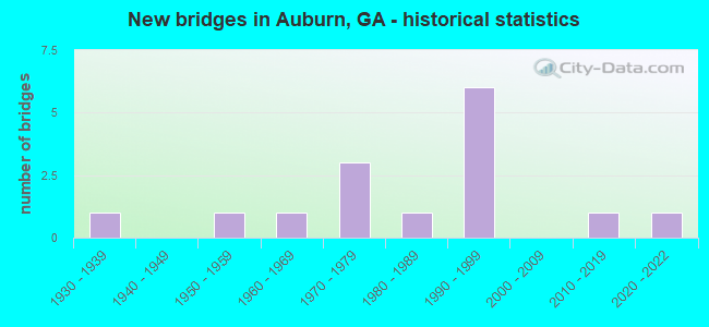
- New bridges - historical statistics
- 11930-1939
- 11950-1959
- 11960-1969
- 31970-1979
- 11980-1989
- 61990-1999
- 12010-2019
- 12020-2022


- Bridge Condition - Deck
- 11.1%Very good
- 66.7%Good
- 22.2%Satisfactory

- Bridge Condition - Superstructure
- 55.6%Very good
- 22.2%Good
- 22.2%Satisfactory

- Bridge Condition - Substructure
- 11.1%Very good
- 55.6%Good
- 33.3%Satisfactory

- Bridge Condition - Channel
- 35.7%Very good
- 28.6%Good
- 14.3%Satisfactory
- 21.4%Fair
Find on map >> Show street view
Structure Number: 130018, Location: 1.5 MI W OF AUBURN (Lat: 34.010697, Lng: -83.854108), Route carried "on" structure: State highway 324, Year Built: 1973, Status: Open, Structure Length: 6.40m (21.00ft), Average Daily Traffic: 6,810 (year 2012), Truck Traffic: 1%, Average Future Daily Traffic: 10,215 (year 2032), Design Load: HS 20+Mod, Features Intersected: CSX RAILROAD, Facility Carried by Structure: HILLS SHOP ROAD
Minimum Vertical Clearance: 30+ m (98+ ft), Kilometerpoint: 1.609, Lanes on structure: 2, Base Highway Network: Yes, Owner: State Highway Agency, Approaching Roadway Width: 6.7m (22.0ft), Skew: 4 degrees, Material/Design: Steel, Design/Construction: Stringer/Multi-beam, Number Of Spans In Main Unit: 3, Length of Maximum Span: 21.3m (69.9ft), Curb or Sidewalk Widths: Left: 0.2m (0.7ft), Right: 0.2m (0.7ft), Curb-To-Curb Width: 9.4m (30.8ft), Out-to-Out Width: 10.4m (34.1ft)
Condition: Deck: Satisfactory, Superstructure: Good, Substructure: Satisfactory, Operating Rating: 32.6 metric tons, Method Used To Determine Operating Rating: Load Factor (LF), Inventory Rating: 19.0 metric tons, Method Used To Determine Inventory Rating: Load Factor (LF), Structural Evaluation: Meets minimum limits, Deck Geometry: Meets minimum limits, Underclear: Meets minimum limits, Approach Roadway Alignment: Somewhat better than minimum adequacy, Designated Inspection Frequency: Every 24 months, Inspection Date: March 2021, Bridge Improvement Cost: $821,000, Roadway Improvement Cost: $82,000, Total Project Cost: $1,231,000, Deck Structure Type: Concrete Cast-file-Place
Find on map >> Show street view
Structure Number: 130024, Location: 1.4 MI N OF AUBURN (Lat: 34.030589, Lng: -83.837339), Route carried "on" structure: County highway 997, Year Built: 1970, Status: Open, Structure Length: 0.64m (2.10ft), Average Daily Traffic: 3,700 (year 2012), Truck Traffic: 1%, Average Future Daily Traffic: 5,550 (year 2032), Design Load: HS 20+Mod, Features Intersected: ROCK CREEK, Facility Carried by Structure: MT. MORIAH ROAD
Minimum Vertical Clearance: 30+ m (98+ ft), Kilometerpoint: 1.609, Lanes on structure: 2, Base Highway Network: Yes, Owner: County Highway Agency, Approaching Roadway Width: 5.8m (19.0ft), Material/Design: Concrete, Design/Construction: Culvert, Number Of Spans In Main Unit: 2, Length of Maximum Span: 3.0m (9.8ft)
Condition: Channel: Satisfactory, Culverts: Good, Operating Rating: 87.0 metric tons, Method Used To Determine Operating Rating: Load Factor (LF), Inventory Rating: 51.7 metric tons, Method Used To Determine Inventory Rating: Load Factor (LF), Structural Evaluation: Better than present minimum criteria, Waterway Adequacy: Equal to present minimum criteria, Approach Roadway Alignment: Equal to present minimum criteria, Designated Inspection Frequency: Every 24 months, Inspection Date: March 2021, Bridge Improvement Cost: $82,000, Roadway Improvement Cost: $8,000, Total Project Cost: $123,000
Find on map >> Show street view
Structure Number: 135005, Location: 3 MI N OF AUBURN (Lat: 34.055578, Lng: -83.825019), Route carried "on" structure: County highway 38, Year Built: 1986, Status: Open, Structure Length: 1.49m (4.89ft), Average Daily Traffic: 490 (year 2012), Truck Traffic: 1%, Average Future Daily Traffic: 735 (year 2032), Design Load: HS 20+Mod, Features Intersected: LITTLE MULBERRY RIVER, Facility Carried by Structure: DEE KENNEDY ROAD
Minimum Vertical Clearance: 30+ m (98+ ft), Kilometerpoint: 6.437, Lanes on structure: 2, Base Highway Network: Yes, Owner: County Highway Agency, Approaching Roadway Width: 6.1m (20.0ft), Skew: 2 degrees, Material/Design: Concrete, Design/Construction: Culvert, Number Of Spans In Main Unit: 4, Length of Maximum Span: 3.4m (11.2ft)
Condition: Channel: Fair, Culverts: Good, Inventory Rating: 64.4 metric tons, Method Used To Determine Inventory Rating: Load Factor (LF), Structural Evaluation: Better than present minimum criteria, Waterway Adequacy: Better than present minimum criteria, Approach Roadway Alignment: Equal to present desirable criteria, Designated Inspection Frequency: Every 24 months, Inspection Date: March 2021, Bridge Improvement Cost: $191,000, Roadway Improvement Cost: $19,000, Total Project Cost: $287,000
Find on map >> Show street view
Structure Number: 135006, Location: 3.6 MI NE OF AUBURN (Lat: 34.060939, Lng: -83.803739), Route carried "on" structure: County highway 42, Year Built: 1963, Status: Posted for load, Structure Length: 3.66m (12.01ft), Average Daily Traffic: 490 (year 2012), Truck Traffic: 1%, Average Future Daily Traffic: 735 (year 2032), Design Load: H 15, Features Intersected: LITTLE MULBERRY RIVER, Facility Carried by Structure: BOSS HARDY ROAD
Minimum Vertical Clearance: 30+ m (98+ ft), Kilometerpoint: 1.609, Lanes on structure: 2, Base Highway Network: Yes, Owner: County Highway Agency, Approaching Roadway Width: 6.1m (20.0ft), Skew: 2 degrees, Material/Design: Concrete, Design/Construction: Tee Beam, Number Of Spans In Main Unit: 3, Length of Maximum Span: 12.2m (40.0ft), Curb or Sidewalk Widths: Left: 0.6m (2.0ft), Right: 0.6m (2.0ft), Curb-To-Curb Width: 7.3m (24.0ft), Out-to-Out Width: 9.1m (29.9ft)
Condition: Deck: Satisfactory, Superstructure: Good, Substructure: Good, Channel: Satisfactory, Operating Rating: 20.8 metric tons, Method Used To Determine Operating Rating: Load Factor (LF), Inventory Rating: 12.7 metric tons, Method Used To Determine Inventory Rating: Load Factor (LF), Structural Evaluation: Meets minimum limits, Deck Geometry: Meets minimum limits, Waterway Adequacy: Better than present minimum criteria, Approach Roadway Alignment: Equal to present minimum criteria, Bridge Posting: Required (Relationship of Operating Rating to Maximum Legal Load: 30.0 - 39.9% below), Designated Inspection Frequency: Every 24 months, Inspection Date: March 2021, Bridge Improvement Cost: $469,000, Roadway Improvement Cost: $47,000, Total Project Cost: $703,000, Deck Structure Type: Concrete Cast-file-Place
Find on map >> Show street view
Structure Number: 13501, Location: IN AUBURN CITY LIMITS (Lat: 34.031028, Lng: -83.826639), Route carried "on" structure: County highway 57, Year Built: 1972, Status: Open, Structure Length: 0.64m (2.10ft), Average Daily Traffic: 1,930 (year 2012), Truck Traffic: 1%, Average Future Daily Traffic: 2,895 (year 2032), Design Load: HS 20+Mod, Features Intersected: ROCK CREEK, Facility Carried by Structure: PARKS MILL ROAD
Minimum Vertical Clearance: 30+ m (98+ ft), Kilometerpoint: 3.219, Lanes on structure: 2, Base Highway Network: Yes, Owner: County Highway Agency, Approaching Roadway Width: 6.1m (20.0ft), Material/Design: Concrete, Design/Construction: Culvert, Number Of Spans In Main Unit: 2, Length of Maximum Span: 3.0m (9.8ft)
Condition: Channel: Very good, Culverts: Good, Inventory Rating: 66.2 metric tons, Method Used To Determine Inventory Rating: Load Factor (LF), Structural Evaluation: Better than present minimum criteria, Waterway Adequacy: Better than present minimum criteria, Approach Roadway Alignment: Equal to present minimum criteria, Designated Inspection Frequency: Every 24 months, Inspection Date: March 2021, Bridge Improvement Cost: $82,000, Roadway Improvement Cost: $8,000, Total Project Cost: $123,000
Find on map >> Show street view
Structure Number: 135017, Location: 3.6 MI S OF CARL (Lat: 33.953089, Lng: -83.813100), Route carried "on" structure: County highway 93, Year Built: 1956, Status: Posted for load, Structure Length: 3.41m (11.19ft), Average Daily Traffic: 3,700 (year 2017), Truck Traffic: 1%, Average Future Daily Traffic: 735 (year 2032), Features Intersected: APALACHEE RIVER, Facility Carried by Structure: PATRICK MILL ROAD
Minimum Vertical Clearance: 30+ m (98+ ft), Kilometerpoint: 6.437, Lanes on structure: 2, Base Highway Network: Yes, Owner: County Highway Agency, Approaching Roadway Width: 6.4m (21.0ft), Material/Design: Steel, Design/Construction: Stringer/Multi-beam, Number Of Spans In Main Unit: 4, Length of Maximum Span: 8.5m (27.9ft), Curb or Sidewalk Widths: Left: 0.2m (0.7ft), Right: 0.2m (0.7ft), Curb-To-Curb Width: 7.4m (24.3ft), Out-to-Out Width: 7.7m (25.3ft)
Condition: Deck: Good, Superstructure: Satisfactory, Substructure: Satisfactory, Channel: Fair, Operating Rating: 29.0 metric tons, Method Used To Determine Operating Rating: Field evaluation and documented engineering judgment, Inventory Rating: 7.2 metric tons, Method Used To Determine Inventory Rating: Field evaluation and documented engineering judgment, Structural Evaluation: High priority of corrective action, Deck Geometry: High priority of replacement, Waterway Adequacy: Equal to present minimum criteria, Approach Roadway Alignment: Equal to present minimum criteria, Bridge Posting: Required (Relationship of Operating Rating to Maximum Legal Load: 20.0 - 29.9% below), Designated Inspection Frequency: Every 24 months, Inspection Date: March 2021, Bridge Improvement Cost: $438,000, Roadway Improvement Cost: $44,000, Total Project Cost: $656,000, Deck Structure Type: Concrete Cast-file-Place, Wearing Surface/Protective System: Wearing Surface: Monolithic Concrete
Find on map >> Show street view
Structure Number: 135045, Location: 2 MI S OF CARL (Lat: 33.984719, Lng: -83.812078), Route carried "on" structure: County highway 82, Year Built: 1993, Status: Open, Structure Length: 1.28m (4.20ft), Average Daily Traffic: 300 (year 2012), Truck Traffic: 1%, Average Future Daily Traffic: 450 (year 2032), Features Intersected: WILLIAMSON CREEK, Facility Carried by Structure: KENNEDY SELLS RD
Minimum Vertical Clearance: 30+ m (98+ ft), Kilometerpoint: 1.609, Lanes on structure: 2, Base Highway Network: Yes, Owner: County Highway Agency, Approaching Roadway Width: 5.5m (18.0ft), Material/Design: Steel, Design/Construction: Stringer/Multi-beam, Number Of Spans In Main Unit: 1, Length of Maximum Span: 12.8m (42.0ft), Curb-To-Curb Width: 7.5m (24.6ft), Out-to-Out Width: 8.3m (27.2ft)
Condition: Deck: Good, Superstructure: Satisfactory, Substructure: Good, Channel: Very good, Operating Rating: 89.8 metric tons, Method Used To Determine Operating Rating: Load Factor (LF), Inventory Rating: 68.9 metric tons, Method Used To Determine Inventory Rating: Load Factor (LF), Structural Evaluation: Equal to present minimum criteria, Deck Geometry: Somewhat better than minimum adequacy, Waterway Adequacy: Superior to present desirable criteria, Approach Roadway Alignment: Equal to present desirable criteria, Designated Inspection Frequency: Every 24 months, Inspection Date: March 2021, Bridge Improvement Cost: $164,000, Roadway Improvement Cost: $16,000, Total Project Cost: $246,000, Deck Structure Type: Concrete Cast-file-Place
Find on map >> Show street view
Structure Number: 135049, Location: 1.9 MI. SW OF AUBURN (Lat: 33.988208, Lng: -83.845239), Route carried "on" structure: County highway 72, Year Built: 1997, Status: Open, Structure Length: 1.74m (5.71ft), Average Daily Traffic: 110 (year 2012), Truck Traffic: 1%, Average Future Daily Traffic: 165 (year 2032), Design Load: HS 20+Mod, Features Intersected: APALACHEE RIVER, Facility Carried by Structure: BROWNS BRIDGE ROAD
Minimum Vertical Clearance: 30+ m (98+ ft), Kilometerpoint: 3.219, Lanes on structure: 2, Base Highway Network: Yes, Owner: County Highway Agency, Approaching Roadway Width: 5.8m (19.0ft), Skew: 2 degrees, Material/Design: Concrete, Design/Construction: Culvert, Number Of Spans In Main Unit: 5, Length of Maximum Span: 3.4m (11.2ft)
Condition: Channel: Good, Culverts: Good, Inventory Rating: 76.2 metric tons, Method Used To Determine Inventory Rating: Load Factor (LF), Structural Evaluation: Better than present minimum criteria, Waterway Adequacy: Equal to present desirable criteria, Approach Roadway Alignment: Equal to present minimum criteria, Designated Inspection Frequency: Every 24 months, Inspection Date: March 2021, Bridge Improvement Cost: $223,000, Roadway Improvement Cost: $22,000, Total Project Cost: $334,000
Find on map >> Show street view
Structure Number: 13505, Location: 3.3 MI. S OF AUBURN (Lat: 33.964128, Lng: -83.824189), Route carried "on" structure: County highway 74, Year Built: 1995, Status: Open, Structure Length: 5.49m (18.01ft), Average Daily Traffic: 490 (year 2012), Truck Traffic: 1%, Average Future Daily Traffic: 735 (year 2032), Design Load: HS 20+Mod, Features Intersected: APALACHEE RIVER, Facility Carried by Structure: FRED KILCREASE RD
Minimum Vertical Clearance: 30+ m (98+ ft), Kilometerpoint: 0.000, Lanes on structure: 2, Base Highway Network: Yes, Owner: County Highway Agency, Approaching Roadway Width: 6.4m (21.0ft), Material/Design: Prestressed concrete, Design/Construction: Stringer/Multi-beam, Number Of Spans In Main Unit: 4, Length of Maximum Span: 13.7m (44.9ft), Curb-To-Curb Width: 9.8m (32.2ft), Out-to-Out Width: 10.7m (35.1ft)
Condition: Deck: Good, Superstructure: Very good, Substructure: Satisfactory, Channel: Fair, Operating Rating: 63.5 metric tons, Method Used To Determine Operating Rating: Load Factor (LF), Inventory Rating: 38.1 metric tons, Method Used To Determine Inventory Rating: Load Factor (LF), Structural Evaluation: Equal to present minimum criteria, Deck Geometry: Equal to present minimum criteria, Waterway Adequacy: Equal to present desirable criteria, Approach Roadway Alignment: Equal to present minimum criteria, Designated Inspection Frequency: Every 24 months, Inspection Date: March 2021, Bridge Improvement Cost: $703,000, Roadway Improvement Cost: $70,000, Total Project Cost: $1,055,000, Deck Structure Type: Concrete Cast-file-Place
Find on map >> Show street view
Structure Number: 135062, Location: 3.5M SOUTH OF CARL (Lat: 33.968447, Lng: -83.790819), Route carried "on" structure: County highway 93, Year Built: 2021, Status: Open, Structure Length: 0.61m (2.00ft), Average Daily Traffic: 620 (year 2011), Truck Traffic: 1%, Average Future Daily Traffic: 930 (year 2031), Features Intersected: WILLIAMSON CREEK, Facility Carried by Structure: PATRICK MILL ROAD
Minimum Vertical Clearance: 30+ m (98+ ft), Kilometerpoint: 3.219, Lanes on structure: 6, Base Highway Network: Yes, Owner: County Highway Agency, Approaching Roadway Width: 21.9m (71.9ft), Skew: 4 degrees, Material/Design: Concrete, Design/Construction: Culvert, Number Of Spans In Main Unit: 2, Length of Maximum Span: 3.0m (9.8ft), Curb or Sidewalk Widths: Left: 1.5m (4.9ft), Right: 1.5m (4.9ft), Curb-To-Curb Width: 21.9m (71.9ft), Out-to-Out Width: 28.0m (91.9ft)
Condition: Channel: Very good, Culverts: Good, Operating Rating: 68.0 metric tons, Method Used To Determine Operating Rating: Load Factor (LF), Inventory Rating: 40.8 metric tons, Method Used To Determine Inventory Rating: Load Factor (LF), Structural Evaluation: Better than present minimum criteria, Deck Geometry: High priority of corrective action, Waterway Adequacy: Equal to present desirable criteria, Approach Roadway Alignment: Equal to present desirable criteria, Length Of Structure Improvement: 0.73m (2.40ft), Designated Inspection Frequency: Every 24 months, Inspection Date: March 2021, Bridge Improvement Cost: $1,776,000, Roadway Improvement Cost: $178,000, Total Project Cost: $2,664,000 ( Estimate for 2021)
Find on map >> Show street view
Structure Number: 1350007, Location: 2 MI NE OF DACULA (Lat: 34.002778, Lng: -83.865719), Route carried "on" structure: US 29, Year Built: 1933, Year Reconstructed: 1957, Status: Open, Structure Length: 1.55m (5.09ft), Average Daily Traffic: 9,310 (year 2012), Truck Traffic: 1%, Average Future Daily Traffic: 13,965 (year 2032), Design Load: H 15, Features Intersected: APALACHEE RIVER
Minimum Vertical Clearance: 30+ m (98+ ft), Kilometerpoint: 37.015, Lanes on structure: 2, Base Highway Network: Yes, Owner: State Highway Agency, Approaching Roadway Width: 8.8m (28.9ft), Material/Design: Concrete, Design/Construction: Culvert, Number Of Spans In Main Unit: 4, Length of Maximum Span: 3.7m (12.1ft)
Condition: Channel: Good, Culverts: Good, Inventory Rating: 76.2 metric tons, Method Used To Determine Inventory Rating: Load Factor (LF), Structural Evaluation: Better than present minimum criteria, Waterway Adequacy: Equal to present desirable criteria, Approach Roadway Alignment: Equal to present minimum criteria, Designated Inspection Frequency: Every 24 months, Inspection Date: September 2021, Bridge Improvement Cost: $199,000, Roadway Improvement Cost: $20,000, Total Project Cost: $299,000
Find on map >> Show street view
Structure Number: 1350117, Location: 4 MI E OF DACULA (Lat: 33.969919, Lng: -83.833578), Route carried "on" structure: US 29, Year Built: 1991, Status: Open, Structure Length: 9.75m (31.99ft), Average Daily Traffic: 28,850 (year 2012), Truck Traffic: 9%, Average Future Daily Traffic: 43,275 (year 2032), Design Load: HS 20+Mod, Features Intersected: APALACHEE RIVER
Minimum Vertical Clearance: 30+ m (98+ ft), Kilometerpoint: 25.750, Lanes on structure: 2, Base Highway Network: Yes, Owner: State Highway Agency, Approaching Roadway Width: 9.8m (32.2ft), Skew: 12 degrees, Material/Design: Prestressed concrete, Design/Construction: Stringer/Multi-beam, Number Of Spans In Main Unit: 8, Length of Maximum Span: 12.2m (40.0ft), Curb-To-Curb Width: 11.6m (38.1ft), Out-to-Out Width: 12.5m (41.0ft)
Condition: Deck: Good, Superstructure: Very good, Substructure: Good, Channel: Good, Operating Rating: 75.2 metric tons, Method Used To Determine Operating Rating: Allowable Stress (AS), Inventory Rating: 42.6 metric tons, Method Used To Determine Inventory Rating: Allowable Stress (AS), Structural Evaluation: Better than present minimum criteria, Deck Geometry: Better than present minimum criteria, Waterway Adequacy: Equal to present desirable criteria, Approach Roadway Alignment: Equal to present desirable criteria, Designated Inspection Frequency: Every 24 months, Inspection Date: September 2021, Bridge Improvement Cost: $1,250,000, Roadway Improvement Cost: $125,000, Total Project Cost: $1,875,000, Deck Structure Type: Concrete Cast-file-Place
Find on map >> Show street view
Structure Number: 1350118, Location: 4 MI E OF DACULA (Lat: 33.970119, Lng: -83.833589), Route carried "on" structure: US 29, Year Built: 1991, Status: Open, Structure Length: 9.75m (31.99ft), Average Daily Traffic: 28,850 (year 2012), Truck Traffic: 9%, Average Future Daily Traffic: 43,275 (year 2032), Design Load: HS 20+Mod, Features Intersected: APALACHEE RIVER
Minimum Vertical Clearance: 30+ m (98+ ft), Kilometerpoint: 25.750, Lanes on structure: 2, Base Highway Network: Yes, Owner: State Highway Agency, Approaching Roadway Width: 9.8m (32.2ft), Skew: 12 degrees, Material/Design: Prestressed concrete, Design/Construction: Stringer/Multi-beam, Number Of Spans In Main Unit: 8, Length of Maximum Span: 12.2m (40.0ft), Curb-To-Curb Width: 11.5m (37.7ft), Out-to-Out Width: 12.4m (40.7ft)
Condition: Deck: Good, Superstructure: Very good, Substructure: Good, Channel: Very good, Operating Rating: 75.2 metric tons, Method Used To Determine Operating Rating: Allowable Stress (AS), Inventory Rating: 42.6 metric tons, Method Used To Determine Inventory Rating: Allowable Stress (AS), Structural Evaluation: Better than present minimum criteria, Deck Geometry: Equal to present minimum criteria, Waterway Adequacy: Equal to present desirable criteria, Approach Roadway Alignment: Equal to present desirable criteria, Designated Inspection Frequency: Every 24 months, Inspection Date: September 2021, Bridge Improvement Cost: $1,250,000, Roadway Improvement Cost: $125,000, Total Project Cost: $1,875,000, Deck Structure Type: Concrete Cast-file-Place
Find on map >> Show street view
Structure Number: 1355151, Location: 5.7 MI N OF DACULA (Lat: 34.062353, Lng: -83.851617), Route carried "on" structure: County highway 1943, Year Built: 1995, Status: Open, Structure Length: 3.38m (11.09ft), Average Daily Traffic: 2,780 (year 2012), Truck Traffic: 1%, Average Future Daily Traffic: 4,170 (year 2032), Design Load: HS 20+Mod, Features Intersected: LITTLE MULBERRY RIVER, Facility Carried by Structure: MT MORIAH ROAD
Minimum Vertical Clearance: 30+ m (98+ ft), Kilometerpoint: 1.609, Lanes on structure: 2, Base Highway Network: Yes, Owner: County Highway Agency, Approaching Roadway Width: 6.7m (22.0ft), Skew: 3 degrees, Material/Design: Prestressed concrete, Design/Construction: Stringer/Multi-beam, Number Of Spans In Main Unit: 3, Length of Maximum Span: 15.5m (50.9ft), Curb-To-Curb Width: 12.2m (40.0ft), Out-to-Out Width: 13.1m (43.0ft)
Condition: Deck: Good, Superstructure: Very good, Substructure: Good, Channel: Good, Operating Rating: 51.7 metric tons, Method Used To Determine Operating Rating: Load Factor (LF), Inventory Rating: 32.6 metric tons, Method Used To Determine Inventory Rating: Load Factor (LF), Structural Evaluation: Better than present minimum criteria, Deck Geometry: Equal to present minimum criteria, Waterway Adequacy: Equal to present desirable criteria, Approach Roadway Alignment: Equal to present desirable criteria, Designated Inspection Frequency: Every 24 months, Inspection Date: September 2021, Bridge Improvement Cost: $434,000, Roadway Improvement Cost: $43,000, Total Project Cost: $651,000, Deck Structure Type: Concrete Cast-file-Place
Find on map >> Show street view
Structure Number: 1355271, Location: 2 MI N OF DACULA (Lat: 34.013500, Lng: -83.879139), Route carried "on" structure: County highway 218, Year Built: 2018, Status: Open, Structure Length: 1.52m (4.99ft), Average Daily Traffic: 3,060 (year 2017), Truck Traffic: 1%, Average Future Daily Traffic: 4,540 (year 2037), Design Load: HL 93, Features Intersected: APALACHEE RIVER TRIB, Facility Carried by Structure: BAILEY ROAD
Minimum Vertical Clearance: 30+ m (98+ ft), Kilometerpoint: 0.000, Lanes on structure: 2, Base Highway Network: Yes, Owner: County Highway Agency, Approaching Roadway Width: 7.9m (25.9ft), Material/Design: Concrete, Design/Construction: Box Beam or Girders - Multiple, Number Of Spans In Main Unit: 1, Length of Maximum Span: 15.2m (49.9ft), Curb or Sidewalk Widths: Left: 1.7m (5.6ft), Right: 1.7m (5.6ft), Curb-To-Curb Width: 8.5m (27.9ft), Out-to-Out Width: 13.7m (44.9ft)
Condition: Deck: Very good, Superstructure: Very good, Substructure: Very good, Channel: Very good, Operating Rating: 82.5 metric tons, Method Used To Determine Operating Rating: Load Factor (LF), Inventory Rating: 47.1 metric tons, Method Used To Determine Inventory Rating: Load Factor (LF), Structural Evaluation: Equal to present desirable criteria, Deck Geometry: Meets minimum limits, Waterway Adequacy: Equal to present desirable criteria, Approach Roadway Alignment: Better than present minimum criteria, Length Of Structure Improvement: 1.83m (6.00ft), Designated Inspection Frequency: Every 24 months, Inspection Date: September 2021, Bridge Improvement Cost: $4,440,000, Roadway Improvement Cost: $444,000, Total Project Cost: $6,660,000 ( Estimate for 2019), Deck Structure Type: Concrete Cast-file-Place, Wearing Surface/Protective System: Wearing Surface: Integral Concrete