Bridge Statistics for Arcata, California (CA)
Condition, Traffic, Stress, Structural Evaluation, Project Costs
- National Bridge Inventory (NBI) Statistics
- 39Number of bridges
- 430ft / 131mTotal length
- $670,000Total costs
- 550,538Total average daily traffic
- 43,888Total average daily truck traffic
- National Bridge Inventory (NBI) Registered Bridges for Arcata
- No street view available for this location
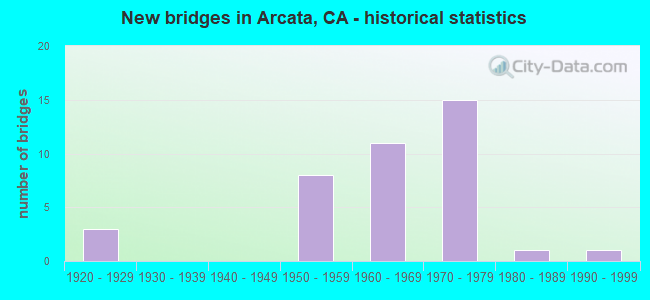
- New bridges - historical statistics
- 31920-1929
- 81950-1959
- 111960-1969
- 151970-1979
- 11980-1989
- 11990-1999

- Reconstructed bridges - Historical Statistics
- 11950-1959
- 01960-1969
- 01970-1979
- 41980-1989
- 11990-1999


- Bridge Condition - Deck
- 58.3%Good
- 4.2%Satisfactory
- 33.3%Fair
- 4.2%Poor

- Bridge Condition - Superstructure
- 66.7%Good
- 29.2%Fair
- 4.2%Poor

- Bridge Condition - Substructure
- 83.3%Good
- 16.7%Fair

- Bridge Condition - Channel
- 15.4%Excellent
- 69.2%Very good
- 15.4%Good
Find on map >> Show street view
Structure Number: 4 0023L, Location: 01-HUM-101-84.50-ARC (Lat: 40.843442, Lng: -124.082069), Route carried "on" structure: US 101, Year Built: 1920, Year Reconstructed: 1955, Status: Open, Structure Length: 2.23m (7.32ft), Average Daily Traffic: 18,125 (year 2009), Truck Traffic: 7%, Average Future Daily Traffic: 26,861 (year 2043), Features Intersected: JACOBY CREEK
Minimum Vertical Clearance: 30+ m (98+ ft), Kilometerpoint: 84.500, Lanes on structure: 2, Base Highway Network: Yes (Inventory Route: 1, Subroute: 1), Owner: State Highway Agency, Approaching Roadway Width: 11.3m (37.1ft), Material/Design: Concrete continuous, Design/Construction: Tee Beam, Number Of Spans In Main Unit: 3, Length of Maximum Span: 7.3m (24.0ft), Curb-To-Curb Width: 11.3m (37.1ft), Out-to-Out Width: 11.9m (39.0ft)
Condition: Deck: Good, Superstructure: Poor, Substructure: Good, Channel: Very good, Operating Rating: 24.6 metric tons, Method Used To Determine Operating Rating: Load and Resistance Factor Rating (LRFR) rating reported by rating factor(RF) method using HL-93 loadings, Inventory Rating: 18.8 metric tons, Method Used To Determine Inventory Rating: Load and Resistance Factor Rating (LRFR) rating reported by rating factor(RF) method using HL-93 loadings, Structural Evaluation: Meets minimum limits, Deck Geometry: Somewhat better than minimum adequacy, Waterway Adequacy: Equal to present desirable criteria, Approach Roadway Alignment: Equal to present desirable criteria, Length Of Structure Improvement: 2.23m (7.32ft), Designated Inspection Frequency: Every 24 months, Inspection Date: January 2021, Bridge Improvement Cost: $264,000, Roadway Improvement Cost: $52,000, Total Project Cost: $443,000 ( Estimate for 2017), Deck Structure Type: Concrete Cast-file-Place, Wearing Surface/Protective System: Wearing Surface: Bituminous
Find on map >> Show street view
Structure Number: 4 0023R, Location: 01-HUM-101-84.50-ARC (Lat: 40.843353, Lng: -124.081692), Route carried "on" structure: US 101, Year Built: 1955, Status: Open, Structure Length: 2.29m (7.51ft), Average Daily Traffic: 18,125 (year 2009), Truck Traffic: 7%, Average Future Daily Traffic: 24,272 (year 2038), Design Load: HS 20, Features Intersected: JACOBY CREEK
Minimum Vertical Clearance: 30+ m (98+ ft), Kilometerpoint: 84.500, Lanes on structure: 2, Base Highway Network: Yes (Inventory Route: 1, Subroute: 1), Owner: State Highway Agency, Approaching Roadway Width: 11.3m (37.1ft), Skew: 1 degrees, Material/Design: Concrete continuous, Design/Construction: Slab, Number Of Spans In Main Unit: 3, Length of Maximum Span: 7.3m (24.0ft), Curb-To-Curb Width: 11.3m (37.1ft), Out-to-Out Width: 12.5m (41.0ft)
Condition: Deck: Good, Superstructure: Good, Substructure: Good, Channel: Very good, Operating Rating: 59.9 metric tons, Method Used To Determine Operating Rating: Load Factor (LF), Inventory Rating: 36.0 metric tons, Method Used To Determine Inventory Rating: Load Factor (LF), Structural Evaluation: Better than present minimum criteria, Deck Geometry: Somewhat better than minimum adequacy, Waterway Adequacy: Equal to present desirable criteria, Approach Roadway Alignment: Equal to present desirable criteria, Designated Inspection Frequency: Every 24 months, Inspection Date: January 2021, Deck Structure Type: Concrete Cast-file-Place, Wearing Surface/Protective System: Wearing Surface: Integral Concrete
Find on map >> Show street view
Structure Number: 4 0024L, Location: 01-HUM-101-84.70 (Lat: 40.846161, Lng: -124.081992), Route carried "on" structure: US 101, Year Built: 1996, Status: Open, Structure Length: 12.12m (39.76ft), Average Daily Traffic: 17,500 (year 2010), Truck Traffic: 10%, Average Future Daily Traffic: 20,911 (year 2041), Design Load: HS 20+Mod, Features Intersected: GANNON SLOUGH
Minimum Vertical Clearance: 30+ m (98+ ft), Kilometerpoint: 84.700, Lanes on structure: 2, Base Highway Network: Yes (Inventory Route: 1, Subroute: 1), Owner: State Highway Agency, Approaching Roadway Width: 11.9m (39.0ft), Material/Design: Concrete continuous, Design/Construction: Slab, Number Of Spans In Main Unit: 11, Length of Maximum Span: 11.0m (36.1ft), Curb-To-Curb Width: 11.9m (39.0ft), Out-to-Out Width: 13.0m (42.7ft)
Condition: Deck: Good, Superstructure: Good, Substructure: Fair, Channel: Very good, Operating Rating: 54.1 metric tons, Method Used To Determine Operating Rating: Assigned rating based on Load Factor Design (LFD) reported in metric tons, Inventory Rating: 32.4 metric tons, Method Used To Determine Inventory Rating: Assigned rating based on Load Factor Design (LFD) reported in metric tons, Structural Evaluation: Somewhat better than minimum adequacy, Deck Geometry: Equal to present minimum criteria, Waterway Adequacy: Equal to present desirable criteria, Approach Roadway Alignment: Equal to present desirable criteria, Designated Inspection Frequency: Every 24 months, Inspection Date: September 2021, Deck Structure Type: Concrete Cast-file-Place
Find on map >> Show street view
Structure Number: 4 0024R, Location: 01-HUM-101-84.70-ARC (Lat: 40.846469, Lng: -124.081617), Route carried "on" structure: US 101, Year Built: 1955, Status: Open, Structure Length: 2.33m (7.64ft), Average Daily Traffic: 17,500 (year 2010), Truck Traffic: 10%, Average Future Daily Traffic: 51,366 (year 2041), Design Load: HS 20, Features Intersected: GANNON SLOUGH
Minimum Vertical Clearance: 30+ m (98+ ft), Kilometerpoint: 84.700, Lanes on structure: 2, Base Highway Network: Yes (Inventory Route: 1, Subroute: 1), Owner: State Highway Agency, Approaching Roadway Width: 11.9m (39.0ft), Material/Design: Concrete continuous, Design/Construction: Slab, Number Of Spans In Main Unit: 4, Length of Maximum Span: 6.4m (21.0ft), Curb-To-Curb Width: 11.9m (39.0ft), Out-to-Out Width: 12.5m (41.0ft)
Condition: Deck: Good, Superstructure: Good, Substructure: Good, Channel: Very good, Operating Rating: 58.3 metric tons, Method Used To Determine Operating Rating: Load and Resistance Factor Rating (LRFR) rating reported by rating factor(RF) method using HL-93 loadings, Inventory Rating: 45.0 metric tons, Method Used To Determine Inventory Rating: Load and Resistance Factor Rating (LRFR) rating reported by rating factor(RF) method using HL-93 loadings, Structural Evaluation: Better than present minimum criteria, Deck Geometry: Equal to present minimum criteria, Waterway Adequacy: Equal to present desirable criteria, Approach Roadway Alignment: Equal to present desirable criteria, Designated Inspection Frequency: Every 24 months, Inspection Date: September 2021, Deck Structure Type: Concrete Cast-file-Place, Wearing Surface/Protective System: Wearing Surface: Bituminous
Find on map >> Show street view
Structure Number: 4 0049, Location: 01-HUM-255-8.77-ARC (Lat: 40.862625, Lng: -124.082119), Route carried "on" structure: State highway 255, Year Built: 1965, Status: Open, Structure Length: 10.00m (32.81ft), Average Daily Traffic: 12,200 (year 2010), Truck Traffic: 8%, Average Future Daily Traffic: 18,875 (year 2041), Design Load: HS 20, Features Intersected: U.S. HIGHWAY 101
Minimum Vertical Clearance: 30+ m (98+ ft), Kilometerpoint: 8.770, Lanes on structure: 4, Lanes under structure: 8, Base Highway Network: Yes (Inventory Route: 2, Subroute: 1), Owner: State Highway Agency, Approaching Roadway Width: 15.8m (51.8ft), Skew: 1 degrees, Material/Design: Concrete continuous, Design/Construction: Box Beam or Girders - Multiple, Number Of Spans In Main Unit: 4, Length of Maximum Span: 32.9m (107.9ft), Curb or Sidewalk Widths: Left: 0.6m (2.0ft), Right: 0.6m (2.0ft), Curb-To-Curb Width: 15.8m (51.8ft), Out-to-Out Width: 17.7m (58.1ft)
Condition: Deck: Satisfactory, Superstructure: Good, Substructure: Good, Operating Rating: 44.7 metric tons, Method Used To Determine Operating Rating: Load and Resistance Factor Rating (LRFR) rating reported by rating factor(RF) method using HL-93 loadings, Inventory Rating: 34.3 metric tons, Method Used To Determine Inventory Rating: Load and Resistance Factor Rating (LRFR) rating reported by rating factor(RF) method using HL-93 loadings, Structural Evaluation: Better than present minimum criteria, Deck Geometry: Meets minimum limits, Underclear: High priority of corrective action, Approach Roadway Alignment: Equal to present desirable criteria, Designated Inspection Frequency: Every 24 months, Inspection Date: September 2021, Deck Structure Type: Concrete Cast-file-Place, Wearing Surface/Protective System: Wearing Surface: Bituminous
Find on map >> Show street view
Structure Number: 4 0054, Location: 01-HUM-101-86.10-ARC (Lat: 40.866572, Lng: -124.083511), Route carried "on" structure: City street , Year Built: 1966, Status: Open, Structure Length: 7.32m (24.02ft), Average Daily Traffic: 3,435 (year 2010), Truck Traffic: 5%, Average Future Daily Traffic: 2,180 (year 2041), Design Load: HS 20, Features Intersected: US HIGHWAY 101, Facility Carried by Structure: SEVENTH ST
Minimum Vertical Clearance: 30+ m (98+ ft), Kilometerpoint: 0.000, Lanes on structure: 2, Lanes under structure: 6, Owner: State Highway Agency, Approaching Roadway Width: 12.2m (40.0ft), Skew: 1 degrees, Material/Design: Concrete continuous, Design/Construction: Box Beam or Girders - Multiple, Number Of Spans In Main Unit: 2, Length of Maximum Span: 39.3m (128.9ft), Curb or Sidewalk Widths: Left: 1.5m (4.9ft), Right: 1.5m (4.9ft), Curb-To-Curb Width: 12.4m (40.7ft), Out-to-Out Width: 16.5m (54.1ft)
Condition: Deck: Fair, Superstructure: Fair, Substructure: Good, Operating Rating: 62.5 metric tons, Method Used To Determine Operating Rating: Load and Resistance Factor Rating (LRFR) rating reported by rating factor(RF) method using HL-93 loadings, Inventory Rating: 45.0 metric tons, Method Used To Determine Inventory Rating: Load and Resistance Factor Rating (LRFR) rating reported by rating factor(RF) method using HL-93 loadings, Structural Evaluation: Somewhat better than minimum adequacy, Deck Geometry: Equal to present minimum criteria, Underclear: High priority of corrective action, Approach Roadway Alignment: Equal to present desirable criteria, Designated Inspection Frequency: Every 24 months, Inspection Date: September 2021, Deck Structure Type: Concrete Cast-file-Place
Find on map >> Show street view
Structure Number: 4 0079L, Location: 01-HUM-101-87.84-ARC (Lat: 40.891383, Lng: -124.080361), Route carried "on" structure: US 101, Year Built: 1956, Year Reconstructed: 1991, Status: Open, Structure Length: 8.05m (26.41ft), Average Daily Traffic: 17,500 (year 2010), Truck Traffic: 12%, Average Future Daily Traffic: 26,381 (year 2041), Design Load: HS 20, Features Intersected: WEST END RD,CREEK, NCRRA
Minimum Vertical Clearance: 30+ m (98+ ft), Kilometerpoint: 87.840, Lanes on structure: 2, Lanes under structure: 2, Base Highway Network: Yes (Inventory Route: 1, Subroute: 1), Owner: State Highway Agency, Approaching Roadway Width: 12.8m (42.0ft), Skew: 3 degrees, Material/Design: Concrete continuous, Design/Construction: Tee Beam, Number Of Spans In Main Unit: 7, Length of Maximum Span: 16.0m (52.5ft), Curb-To-Curb Width: 11.8m (38.7ft), Out-to-Out Width: 12.8m (42.0ft)
Condition: Deck: Fair, Superstructure: Good, Substructure: Good, Channel: Excellent, Operating Rating: 32.4 metric tons, Method Used To Determine Operating Rating: Load and Resistance Factor Rating (LRFR) rating reported by rating factor(RF) method using HL-93 loadings, Inventory Rating: 23.0 metric tons, Method Used To Determine Inventory Rating: Load and Resistance Factor Rating (LRFR) rating reported by rating factor(RF) method using HL-93 loadings, Structural Evaluation: Somewhat better than minimum adequacy, Deck Geometry: Equal to present minimum criteria, Underclear: High priority of corrective action, Waterway Adequacy: Meets minimum limits, Approach Roadway Alignment: Equal to present desirable criteria, Designated Inspection Frequency: Every 24 months, Inspection Date: September 2021, Deck Structure Type: Concrete Cast-file-Place
Find on map >> Show street view
Structure Number: 4 0079R, Location: 01-HUM-101-87.84-ARC (Lat: 40.891542, Lng: -124.080219), Route carried "on" structure: US 101, Year Built: 1929, Year Reconstructed: 1995, Status: Open, Structure Length: 8.07m (26.48ft), Average Daily Traffic: 17,500 (year 2010), Truck Traffic: 12%, Average Future Daily Traffic: 26,381 (year 2041), Features Intersected: WEST END RD,CREEK, NCRRA
Minimum Vertical Clearance: 30+ m (98+ ft), Kilometerpoint: 87.840, Lanes on structure: 2, Lanes under structure: 2, Base Highway Network: Yes (Inventory Route: 1, Subroute: 1), Owner: State Highway Agency, Approaching Roadway Width: 11.9m (39.0ft), Skew: 3 degrees, Material/Design: Steel, Design/Construction: Stringer/Multi-beam, Number Of Spans In Main Unit: 2, Number Of Approach Spans: 5, Length of Maximum Span: 14.7m (48.2ft), Curb-To-Curb Width: 11.9m (39.0ft), Out-to-Out Width: 12.8m (42.0ft)
Condition: Deck: Poor, Superstructure: Fair, Substructure: Good, Channel: Excellent, Operating Rating: 34.0 metric tons, Method Used To Determine Operating Rating: Load Factor (LF), Inventory Rating: 20.4 metric tons, Method Used To Determine Inventory Rating: Load Factor (LF), Structural Evaluation: Somewhat better than minimum adequacy, Deck Geometry: Equal to present minimum criteria, Underclear: High priority of corrective action, Waterway Adequacy: Meets minimum limits, Approach Roadway Alignment: Equal to present desirable criteria, Designated Inspection Frequency: Every 24 months, Critical Feature Inspection Frequency: Every 24 months, Inspection Date: September 2021, Critical Feature Inspection Date: October 2021, Deck Structure Type: Concrete Cast-file-Place, Wearing Surface/Protective System: Wearing Surface: Bituminous
Find on map >> Show street view
Structure Number: 4 0083, Location: 01-HUM-101-88.87 (Lat: 40.905353, Lng: -124.087142), Route carried "on" structure: US 101, Year Built: 1959, Year Reconstructed: 1991, Status: Open, Structure Length: 4.02m (13.19ft), Average Daily Traffic: 12,900 (year 2010), Truck Traffic: 10%, Average Future Daily Traffic: 42,788 (year 2041), Design Load: HS 20, Features Intersected: JONES SLOUGH
Minimum Vertical Clearance: 30+ m (98+ ft), Kilometerpoint: 88.870, Lanes on structure: 4, Base Highway Network: Yes (Inventory Route: 1, Subroute: 1), Owner: State Highway Agency, Approaching Roadway Width: 27.1m (88.9ft), Skew: 30 degrees, Material/Design: Concrete continuous, Design/Construction: Tee Beam, Number Of Spans In Main Unit: 4, Length of Maximum Span: 11.0m (36.1ft), Curb-To-Curb Width: 27.1m (88.9ft), Out-to-Out Width: 28.6m (93.8ft)
Condition: Deck: Fair, Superstructure: Good, Substructure: Good, Channel: Very good, Operating Rating: 20.4 metric tons, Method Used To Determine Operating Rating: Load and Resistance Factor Rating (LRFR) rating reported by rating factor(RF) method using HL-93 loadings, Inventory Rating: 14.3 metric tons, Method Used To Determine Inventory Rating: Load and Resistance Factor Rating (LRFR) rating reported by rating factor(RF) method using HL-93 loadings, Structural Evaluation: High priority of corrective action, Deck Geometry: Superior to present desirable criteria, Waterway Adequacy: Equal to present desirable criteria, Approach Roadway Alignment: Equal to present desirable criteria, Designated Inspection Frequency: Every 24 months, Inspection Date: September 2021, Deck Structure Type: Concrete Cast-file-Place, Wearing Surface/Protective System: Wearing Surface: Integral Concrete
Find on map >> Show street view
Structure Number: 4 0084, Location: 01-HUM-101-89.18 (Lat: 40.909644, Lng: -124.089311), Route carried "on" structure: US 101, Year Built: 1956, Year Reconstructed: 1988, Status: Open, Structure Length: 3.42m (11.22ft), Average Daily Traffic: 12,900 (year 2010), Truck Traffic: 10%, Average Future Daily Traffic: 34,852 (year 2041), Design Load: HS 20+Mod, Features Intersected: TURNER DRAW
Minimum Vertical Clearance: 30+ m (98+ ft), Kilometerpoint: 89.180, Lanes on structure: 4, Base Highway Network: Yes (Inventory Route: 1, Subroute: 1), Owner: State Highway Agency, Approaching Roadway Width: 25.9m (85.0ft), Skew: 31 degrees, Material/Design: Concrete continuous, Design/Construction: Tee Beam, Number Of Spans In Main Unit: 3, Length of Maximum Span: 13.4m (44.0ft), Curb-To-Curb Width: 25.9m (85.0ft), Out-to-Out Width: 27.4m (89.9ft)
Condition: Deck: Fair, Superstructure: Good, Substructure: Good, Channel: Very good, Operating Rating: 42.4 metric tons, Method Used To Determine Operating Rating: Load and Resistance Factor Rating (LRFR) rating reported by rating factor(RF) method using HL-93 loadings, Inventory Rating: 32.1 metric tons, Method Used To Determine Inventory Rating: Load and Resistance Factor Rating (LRFR) rating reported by rating factor(RF) method using HL-93 loadings, Structural Evaluation: Better than present minimum criteria, Deck Geometry: Superior to present desirable criteria, Waterway Adequacy: Equal to present desirable criteria, Approach Roadway Alignment: Equal to present desirable criteria, Designated Inspection Frequency: Every 24 months, Inspection Date: September 2021, Deck Structure Type: Concrete Cast-file-Place, Wearing Surface/Protective System: Wearing Surface: Integral Concrete
Find on map >> Show street view
Structure Number: 4 0157, Location: 01-HUM-101-88.80-ARC (Lat: 40.904311, Lng: -124.087153), Route carried "on" structure: County highway , Year Built: 1969, Status: Open, Structure Length: 5.47m (17.95ft), Average Daily Traffic: 11,131 (year 2010), Truck Traffic: 5%, Average Future Daily Traffic: 21,448 (year 2041), Design Load: HS 20, Features Intersected: US HIGHWAY 101, Facility Carried by Structure: GUINTOLI LANE
Minimum Vertical Clearance: 30+ m (98+ ft), Kilometerpoint: 0.000, Lanes on structure: 2, Lanes under structure: 4, Base Highway Network: Yes, Owner: State Highway Agency, Approaching Roadway Width: 12.2m (40.0ft), Material/Design: Prestressed concrete, Design/Construction: Box Beam or Girders - Multiple, Number Of Spans In Main Unit: 1, Length of Maximum Span: 54.3m (178.1ft), Curb or Sidewalk Widths: Left: 0.0m, Right: 1.5m (4.9ft), Curb-To-Curb Width: 12.2m (40.0ft), Out-to-Out Width: 14.6m (47.9ft)
Condition: Deck: Fair, Superstructure: Good, Substructure: Fair, Operating Rating: 54.1 metric tons, Method Used To Determine Operating Rating: Load and Resistance Factor Rating (LRFR) rating reported by rating factor(RF) method using HL-93 loadings, Inventory Rating: 29.5 metric tons, Method Used To Determine Inventory Rating: Load and Resistance Factor Rating (LRFR) rating reported by rating factor(RF) method using HL-93 loadings, Structural Evaluation: Somewhat better than minimum adequacy, Deck Geometry: Somewhat better than minimum adequacy, Underclear: Somewhat better than minimum adequacy, Approach Roadway Alignment: Equal to present desirable criteria, Designated Inspection Frequency: Every 24 months, Inspection Date: September 2021, Deck Structure Type: Concrete Cast-file-Place
Find on map >> Show street view
Structure Number: 4 0161, Location: 01-HUM-299-0.01-ARC (Lat: 40.897042, Lng: -124.083475), Route carried "on" structure: State highway 299, Year Built: 1956, Year Reconstructed: 1992, Status: Open, Structure Length: 4.72m (15.49ft), Average Daily Traffic: 12,400 (year 2009), Truck Traffic: 7%, Average Future Daily Traffic: 15,455 (year 2038), Design Load: HS 20, Features Intersected: US HIGHWAY 101
Minimum Vertical Clearance: 30+ m (98+ ft), Kilometerpoint: 0.010, Lanes on structure: 2, Lanes under structure: 4, Base Highway Network: Yes (Inventory Route: 2, Subroute: 1), Owner: State Highway Agency, Approaching Roadway Width: 9.6m (31.5ft), Skew: 9 degrees, Material/Design: Prestressed concrete, Design/Construction: Tee Beam, Number Of Spans In Main Unit: 1, Number Of Approach Spans: 3, Length of Maximum Span: 14.3m (46.9ft), Curb-To-Curb Width: 9.6m (31.5ft), Out-to-Out Width: 10.8m (35.4ft)
Condition: Deck: Good, Superstructure: Good, Substructure: Good, Operating Rating: 64.5 metric tons, Method Used To Determine Operating Rating: Load Factor (LF), Inventory Rating: 32.4 metric tons, Method Used To Determine Inventory Rating: Load Factor (LF), Structural Evaluation: Better than present minimum criteria, Deck Geometry: High priority of corrective action, Underclear: High priority of corrective action, Approach Roadway Alignment: Equal to present minimum criteria, Designated Inspection Frequency: Every 48 months, Inspection Date: January 2021, Deck Structure Type: Concrete Cast-file-Place, Wearing Surface/Protective System: Wearing Surface: Bituminous
Find on map >> Show street view
Structure Number: 4 0222, Location: 01-HUM-255-7.77 (Lat: 40.867861, Lng: -124.102117), Route carried "on" structure: State highway 255, Year Built: 1963, Status: Open, Structure Length: 0.67m (2.20ft), Average Daily Traffic: 4,160 (year 2010), Truck Traffic: 8%, Average Future Daily Traffic: 8,042 (year 2037), Design Load: HS 20, Features Intersected: MCDANIEL SLOUGH
Minimum Vertical Clearance: 30+ m (98+ ft), Kilometerpoint: 7.770, Lanes on structure: 4, Owner: State Highway Agency, Approaching Roadway Width: 26.8m (87.9ft), Skew: 20 degrees, Material/Design: Concrete continuous, Design/Construction: Culvert, Number Of Spans In Main Unit: 2, Length of Maximum Span: 3.0m (9.8ft), Curb-To-Curb Width: 26.2m (86.0ft), Out-to-Out Width: 26.2m (86.0ft)
Condition: Channel: Very good, Culverts: Good, Operating Rating: 54.1 metric tons, Method Used To Determine Operating Rating: Field evaluation and documented engineering judgment, Inventory Rating: 32.4 metric tons, Method Used To Determine Inventory Rating: Field evaluation and documented engineering judgment, Structural Evaluation: Better than present minimum criteria, Deck Geometry: Superior to present desirable criteria, Waterway Adequacy: Equal to present desirable criteria, Approach Roadway Alignment: Equal to present desirable criteria, Designated Inspection Frequency: Every 48 months, Inspection Date: September 2019
Find on map >> Show street view
Structure Number: 4 0231, Location: 01-HUM-299-0.72-ARC (Lat: 40.904267, Lng: -124.073797), Route carried "on" structure: County highway , Year Built: 1969, Status: Open, Structure Length: 4.88m (16.01ft), Average Daily Traffic: 5,644 (year 2010), Truck Traffic: 15%, Average Future Daily Traffic: 15,248 (year 2041), Design Load: HS 20, Features Intersected: STATE ROUTE 299, Facility Carried by Structure: GUINTOLI LANE
Minimum Vertical Clearance: 30+ m (98+ ft), Kilometerpoint: 0.000, Lanes on structure: 2, Lanes under structure: 4, Owner: State Highway Agency, Approaching Roadway Width: 12.2m (40.0ft), Skew: 2 degrees, Material/Design: Prestressed concrete, Design/Construction: Box Beam or Girders - Multiple, Number Of Spans In Main Unit: 1, Length of Maximum Span: 48.5m (159.1ft), Curb-To-Curb Width: 12.2m (40.0ft), Out-to-Out Width: 12.8m (42.0ft)
Condition: Deck: Good, Superstructure: Good, Substructure: Good, Operating Rating: 57.0 metric tons, Method Used To Determine Operating Rating: Load and Resistance Factor Rating (LRFR) rating reported by rating factor(RF) method using HL-93 loadings, Inventory Rating: 32.7 metric tons, Method Used To Determine Inventory Rating: Load and Resistance Factor Rating (LRFR) rating reported by rating factor(RF) method using HL-93 loadings, Structural Evaluation: Better than present minimum criteria, Deck Geometry: Somewhat better than minimum adequacy, Underclear: High priority of corrective action, Approach Roadway Alignment: Equal to present desirable criteria, Designated Inspection Frequency: Every 24 months, Inspection Date: January 2021, Deck Structure Type: Concrete Cast-file-Place
Find on map >> Show street view
Structure Number: 4 0242, Location: 01-HUM-101-86.33-ARC (Lat: 40.869953, Lng: -124.083375), Route carried "on" structure: City street , Year Built: 1976, Status: Open, Structure Length: 8.25m (27.07ft), Average Daily Traffic: 2,956 (year 2010), Truck Traffic: 5%, Average Future Daily Traffic: 2,180 (year 2041), Design Load: HS 20, Features Intersected: US HIGHWAY 101, Facility Carried by Structure: 11TH ST
Minimum Vertical Clearance: 30+ m (98+ ft), Kilometerpoint: 0.000, Lanes on structure: 2, Lanes under structure: 4, Owner: State Highway Agency, Approaching Roadway Width: 12.2m (40.0ft), Material/Design: Prestressed concrete continuous, Design/Construction: Box Beam or Girders - Multiple, Number Of Spans In Main Unit: 2, Length of Maximum Span: 48.8m (160.1ft), Curb or Sidewalk Widths: Left: 1.5m (4.9ft), Right: 1.5m (4.9ft), Curb-To-Curb Width: 12.2m (40.0ft), Out-to-Out Width: 15.8m (51.8ft)
Condition: Deck: Good, Superstructure: Fair, Substructure: Good, Operating Rating: 56.4 metric tons, Method Used To Determine Operating Rating: Load and Resistance Factor Rating (LRFR) rating reported by rating factor(RF) method using HL-93 loadings, Inventory Rating: 43.4 metric tons, Method Used To Determine Inventory Rating: Load and Resistance Factor Rating (LRFR) rating reported by rating factor(RF) method using HL-93 loadings, Structural Evaluation: Somewhat better than minimum adequacy, Deck Geometry: Equal to present minimum criteria, Underclear: Equal to present minimum criteria, Approach Roadway Alignment: Equal to present desirable criteria, Designated Inspection Frequency: Every 24 months, Inspection Date: September 2021, Deck Structure Type: Concrete Cast-file-Place, Wearing Surface/Protective System: Wearing Surface: Integral Concrete
Find on map >> Show street view
Structure Number: 4 0243, Location: 01-HUM-101-86.77-ARC (Lat: 40.875731, Lng: -124.083103), Route carried "on" structure: City street , Year Built: 1976, Status: Open, Structure Length: 10.25m (33.63ft), Average Daily Traffic: 5,209 (year 2010), Truck Traffic: 5%, Average Future Daily Traffic: 12,868 (year 2041), Design Load: HS 20, Features Intersected: US HIGHWAY 101, Facility Carried by Structure: G STREET
Minimum Vertical Clearance: 30+ m (98+ ft), Kilometerpoint: 0.000, Lanes on structure: 2, Lanes under structure: 4, Owner: State Highway Agency, Approaching Roadway Width: 9.8m (32.2ft), Skew: 9 degrees, Material/Design: Prestressed concrete continuous, Design/Construction: Box Beam or Girders - Multiple, Number Of Spans In Main Unit: 2, Length of Maximum Span: 56.4m (185.0ft), Curb-To-Curb Width: 9.8m (32.2ft), Out-to-Out Width: 10.8m (35.4ft)
Condition: Deck: Good, Superstructure: Good, Substructure: Good, Operating Rating: 99.8 metric tons, Method Used To Determine Operating Rating: Load Factor (LF), Inventory Rating: 32.4 metric tons, Method Used To Determine Inventory Rating: Load Factor (LF), Structural Evaluation: Better than present minimum criteria, Deck Geometry: Meets minimum limits, Underclear: Meets minimum limits, Approach Roadway Alignment: Equal to present minimum criteria, Designated Inspection Frequency: Every 24 months, Inspection Date: September 2021, Deck Structure Type: Concrete Cast-file-Place, Wearing Surface/Protective System: Wearing Surface: Bituminous
Find on map >> Show street view
Structure Number: 4 0244, Location: 01-HUM-101-86.94-ARC (Lat: 40.878669, Lng: -124.082697), Route carried "on" structure: City street , Year Built: 1976, Status: Open, Structure Length: 7.89m (25.89ft), Average Daily Traffic: 6,378 (year 2010), Truck Traffic: 5%, Average Future Daily Traffic: 12,868 (year 2041), Design Load: HS 20, Features Intersected: US HIGHWAY 101, Facility Carried by Structure: SUNSET AVE
Minimum Vertical Clearance: 30+ m (98+ ft), Kilometerpoint: 0.000, Lanes on structure: 4, Lanes under structure: 6, Base Highway Network: Yes, Owner: State Highway Agency, Approaching Roadway Width: 17.1m (56.1ft), Material/Design: Prestressed concrete continuous, Design/Construction: Box Beam or Girders - Multiple, Number Of Spans In Main Unit: 2, Length of Maximum Span: 46.3m (151.9ft), Curb or Sidewalk Widths: Left: 0.0m, Right: 2.8m (9.2ft), Curb-To-Curb Width: 17.1m (56.1ft), Out-to-Out Width: 20.7m (67.9ft)
Condition: Deck: Good, Superstructure: Good, Substructure: Good, Operating Rating: 59.6 metric tons, Method Used To Determine Operating Rating: Load and Resistance Factor Rating (LRFR) rating reported by rating factor(RF) method using HL-93 loadings, Inventory Rating: 37.6 metric tons, Method Used To Determine Inventory Rating: Load and Resistance Factor Rating (LRFR) rating reported by rating factor(RF) method using HL-93 loadings, Structural Evaluation: Better than present minimum criteria, Deck Geometry: Somewhat better than minimum adequacy, Underclear: Better than present minimum criteria, Approach Roadway Alignment: Equal to present minimum criteria, Designated Inspection Frequency: Every 24 months, Inspection Date: September 2021, Deck Structure Type: Concrete Cast-file-Place, Wearing Surface/Protective System: Wearing Surface: Integral Concrete
Find on map >> Show street view
Structure Number: 4 0245, Location: 01-HUM-101-86.50-ARC (Lat: 40.872389, Lng: -124.082806), Route carried "on" structure: City street , Year Built: 1976, Status: Open, Structure Length: 6.58m (21.59ft), Average Daily Traffic: 5,597 (year 2010), Truck Traffic: 5%, Average Future Daily Traffic: 12,868 (year 2041), Design Load: HS 20, Features Intersected: US HIGHWAY 101, Facility Carried by Structure: 14TH ST
Minimum Vertical Clearance: 30+ m (98+ ft), Kilometerpoint: 0.000, Lanes on structure: 3, Lanes under structure: 4, Owner: State Highway Agency, Approaching Roadway Width: 16.5m (54.1ft), Skew: 1 degrees, Material/Design: Concrete continuous, Design/Construction: Box Beam or Girders - Multiple, Number Of Spans In Main Unit: 2, Length of Maximum Span: 37.2m (122.0ft), Curb or Sidewalk Widths: Left: 2.4m (7.9ft), Right: 0.0m, Curb-To-Curb Width: 17.1m (56.1ft), Out-to-Out Width: 20.3m (66.6ft)
Condition: Deck: Fair, Superstructure: Fair, Substructure: Good, Operating Rating: 65.4 metric tons, Method Used To Determine Operating Rating: Load and Resistance Factor Rating (LRFR) rating reported by rating factor(RF) method using HL-93 loadings, Inventory Rating: 50.5 metric tons, Method Used To Determine Inventory Rating: Load and Resistance Factor Rating (LRFR) rating reported by rating factor(RF) method using HL-93 loadings, Structural Evaluation: Somewhat better than minimum adequacy, Deck Geometry: Superior to present desirable criteria, Underclear: Meets minimum limits, Approach Roadway Alignment: Equal to present desirable criteria, Designated Inspection Frequency: Every 24 months, Inspection Date: September 2021, Deck Structure Type: Concrete Cast-file-Place
Find on map >> Show street view
Structure Number: 4 0254, Location: 01-HUM-101-87.48-ARC (Lat: 40.886433, Lng: -124.080819), Route carried "on" structure: City street , Year Built: 1976, Status: Open, Structure Length: 11.70m (38.39ft), Average Daily Traffic: 2,099 (year 2010), Truck Traffic: 5%, Average Future Daily Traffic: 2,180 (year 2041), Design Load: HS 20, Features Intersected: US HIGHWAY 101 & NCRRA, Facility Carried by Structure: SAINT LOUIS RD
Minimum Vertical Clearance: 30+ m (98+ ft), Kilometerpoint: 0.000, Lanes on structure: 2, Lanes under structure: 4, Owner: State Highway Agency, Approaching Roadway Width: 12.2m (40.0ft), Material/Design: Concrete continuous, Design/Construction: Box Beam or Girders - Multiple, Number Of Spans In Main Unit: 4, Length of Maximum Span: 34.1m (111.9ft), Curb or Sidewalk Widths: Left: 0.0m, Right: 2.8m (9.2ft), Curb-To-Curb Width: 12.2m (40.0ft), Out-to-Out Width: 15.8m (51.8ft)
Condition: Deck: Fair, Superstructure: Fair, Substructure: Good, Operating Rating: 99.8 metric tons, Method Used To Determine Operating Rating: Load Factor (LF), Inventory Rating: 60.9 metric tons, Method Used To Determine Inventory Rating: Load Factor (LF), Structural Evaluation: Somewhat better than minimum adequacy, Deck Geometry: Equal to present minimum criteria, Underclear: Meets minimum limits, Approach Roadway Alignment: Equal to present desirable criteria, Designated Inspection Frequency: Every 24 months, Inspection Date: September 2021, Deck Structure Type: Concrete Cast-file-Place
Find on map >> Show street view
Structure Number: 4C0124, Location: 0.1 MI S/O JACOBY CRK RD (Lat: 40.832006, Lng: -124.045392), Route carried "on" structure: County highway , Year Built: 1967, Status: Open, Structure Length: 2.07m (6.79ft), Average Daily Traffic: 162 (year 2011), Truck Traffic: 1%, Average Future Daily Traffic: 256 (year 2043), Features Intersected: JACOBY CREEK, Facility Carried by Structure: BROOKWOOD DRIVE
Minimum Vertical Clearance: 4.39m (14.40ft), Kilometerpoint: 0.000, Lanes on structure: 1, Owner: County Highway Agency, Approaching Roadway Width: 4.2m (13.8ft), Material/Design: Wood or Timber, Design/Construction: Truss - Thru, Number Of Spans In Main Unit: 1, Length of Maximum Span: 18.3m (60.0ft), Curb or Sidewalk Widths: Left: 0.9m (3.0ft), Right: 0.6m (2.0ft), Curb-To-Curb Width: 4.2m (13.8ft), Out-to-Out Width: 6.0m (19.7ft)
Condition: Deck: Good, Superstructure: Fair, Substructure: Fair, Channel: Good, Operating Rating: 27.9 metric tons, Method Used To Determine Operating Rating: Allowable Stress (AS), Inventory Rating: 20.4 metric tons, Method Used To Determine Inventory Rating: Allowable Stress (AS), Structural Evaluation: Somewhat better than minimum adequacy, Deck Geometry: High priority of replacement, Waterway Adequacy: Better than present minimum criteria, Approach Roadway Alignment: Equal to present minimum criteria, Designated Inspection Frequency: Every 24 months, Critical Feature Inspection Frequency: Every 24 months, Inspection Date: June 2021, Critical Feature Inspection Date: October 2021, Deck Structure Type: Wood or Timber, Wearing Surface/Protective System: Wearing Surface: Wood or Timber
Find on map >> Show street view
Structure Number: 4C0136, Location: 0.03 MI S FRESHWATER RD (Lat: 40.756700, Lng: -124.049358), Route carried "on" structure: County highway , Year Built: 1972, Status: Open, Structure Length: 1.65m (5.41ft), Average Daily Traffic: 100 (year 2010), Average Future Daily Traffic: 88 (year 2041), Features Intersected: FRESHWATER CREEK, Facility Carried by Structure: FRESHWATER POOL RD
Minimum Vertical Clearance: 30+ m (98+ ft), Kilometerpoint: 0.000, Lanes on structure: 1, Owner: County Highway Agency, Approaching Roadway Width: 4.0m (13.1ft), Material/Design: Steel, Design/Construction: Stringer/Multi-beam, Number Of Spans In Main Unit: 1, Length of Maximum Span: 15.5m (50.9ft), Curb or Sidewalk Widths: Left: 0.2m (0.7ft), Right: 0.2m (0.7ft), Curb-To-Curb Width: 3.6m (11.8ft), Out-to-Out Width: 3.6m (11.8ft)
Condition: Deck: Good, Superstructure: Fair, Substructure: Fair, Channel: Good, Operating Rating: 48.9 metric tons, Method Used To Determine Operating Rating: Load Factor (LF), Inventory Rating: 29.2 metric tons, Method Used To Determine Inventory Rating: Load Factor (LF), Structural Evaluation: Somewhat better than minimum adequacy, Deck Geometry: High priority of corrective action, Waterway Adequacy: Better than present minimum criteria, Approach Roadway Alignment: Equal to present minimum criteria, Length Of Structure Improvement: 1.65m (5.41ft), Designated Inspection Frequency: Every 24 months, Critical Feature Inspection Frequency: Every 24 months, Inspection Date: June 2021, Critical Feature Inspection Date: June 2021, Bridge Improvement Cost: $135,000, Roadway Improvement Cost: $27,000, Total Project Cost: $227,000 ( Estimate for 2017), Deck Structure Type: Wood or Timber, Wearing Surface/Protective System: Wearing Surface: Wood or Timber
Find on map >> Show street view
Structure Number: 4C0182, Location: 1/4 MI N BAYSIDE CUTOFF (Lat: 40.837686, Lng: -124.070064), Route carried "on" structure: County highway , Year Built: 1988, Status: Open, Structure Length: 2.74m (8.99ft), Average Daily Traffic: 3,030 (year 2011), Truck Traffic: 4%, Average Future Daily Traffic: 7,268 (year 2037), Design Load: HS 20+Mod, Features Intersected: JACOBY CREEK, Facility Carried by Structure: OLD ARCATA RD
Minimum Vertical Clearance: 30+ m (98+ ft), Kilometerpoint: 0.000, Lanes on structure: 2, Owner: County Highway Agency, Approaching Roadway Width: 7.3m (24.0ft), Skew: 2 degrees, Material/Design: Prestressed concrete, Design/Construction: Slab, Number Of Spans In Main Unit: 2, Length of Maximum Span: 13.7m (44.9ft), Curb-To-Curb Width: 10.8m (35.4ft), Out-to-Out Width: 11.0m (36.1ft)
Condition: Deck: Good, Superstructure: Good, Substructure: Good, Channel: Very good, Operating Rating: 54.1 metric tons, Method Used To Determine Operating Rating: Assigned rating based on Load Factor Design (LFD) reported in metric tons, Inventory Rating: 32.4 metric tons, Method Used To Determine Inventory Rating: Assigned rating based on Load Factor Design (LFD) reported in metric tons, Structural Evaluation: Better than present minimum criteria, Deck Geometry: Somewhat better than minimum adequacy, Waterway Adequacy: Better than present minimum criteria, Approach Roadway Alignment: Equal to present desirable criteria, Designated Inspection Frequency: Every 48 months, Inspection Date: June 2019, Deck Structure Type: Concrete Cast-file-Place, Wearing Surface/Protective System: Wearing Surface: Bituminous
Find on map >> Show street view
Structure Number: 4C0185, Location: 0.25 MI S FOSTER AVE (Lat: 40.879636, Lng: -124.130481), Route carried "on" structure: County highway , Year Built: 1960, Status: Open, Structure Length: 2.23m (7.32ft), Average Daily Traffic: 327 (year 2011), Truck Traffic: 5%, Average Future Daily Traffic: 515 (year 2043), Design Load: H 20, Features Intersected: LISCOMB SLOUGH, Facility Carried by Structure: JACKSON RANCH RD
Minimum Vertical Clearance: 30+ m (98+ ft), Kilometerpoint: 0.000, Lanes on structure: 2, Owner: County Highway Agency, Approaching Roadway Width: 6.1m (20.0ft), Material/Design: Concrete continuous, Design/Construction: Slab, Number Of Spans In Main Unit: 3, Length of Maximum Span: 8.5m (27.9ft), Curb-To-Curb Width: 6.5m (21.3ft), Out-to-Out Width: 6.7m (22.0ft)
Condition: Deck: Good, Superstructure: Good, Substructure: Good, Channel: Very good, Operating Rating: 63.8 metric tons, Method Used To Determine Operating Rating: Load Factor (LF), Inventory Rating: 38.2 metric tons, Method Used To Determine Inventory Rating: Load Factor (LF), Structural Evaluation: Better than present minimum criteria, Deck Geometry: Meets minimum limits, Waterway Adequacy: Better than present minimum criteria, Approach Roadway Alignment: Somewhat better than minimum adequacy, Designated Inspection Frequency: Every 24 months, Inspection Date: June 2021, Deck Structure Type: Concrete Cast-file-Place
Find on map >> Show street view
Structure Number: 4C0232L, Location: 0.2 MI N 14TH ST (Lat: 40.875367, Lng: -124.081844), Route carried "on" structure: City street , Year Built: 1976, Status: Open, Structure Length: 1.23m (4.04ft), Average Daily Traffic: 2,000 (year 2002), Truck Traffic: 2%, Average Future Daily Traffic: 3,630 (year 2041), Design Load: HS 20+Mod, Features Intersected: PEDESTRIAN WALKWAY, Facility Carried by Structure: EAST FRONTAGE ROAD
Minimum Vertical Clearance: 30+ m (98+ ft), Kilometerpoint: 0.000, Lanes on structure: 1, Owner: City or Municipal Highway Agency, Approaching Roadway Width: 7.9m (25.9ft), Material/Design: Concrete, Design/Construction: Box Beam or Girders - Multiple, Number Of Spans In Main Unit: 1, Length of Maximum Span: 11.9m (39.0ft), Curb-To-Curb Width: 7.9m (25.9ft), Out-to-Out Width: 9.2m (30.2ft)
Condition: Deck: Good, Superstructure: Good, Substructure: Good, Operating Rating: 35.0 metric tons, Method Used To Determine Operating Rating: Load and Resistance Factor Rating (LRFR) rating reported by rating factor(RF) method using HL-93 loadings, Inventory Rating: 26.9 metric tons, Method Used To Determine Inventory Rating: Load and Resistance Factor Rating (LRFR) rating reported by rating factor(RF) method using HL-93 loadings, Structural Evaluation: Equal to present minimum criteria, Deck Geometry: Meets minimum limits, Approach Roadway Alignment: Equal to present desirable criteria, Designated Inspection Frequency: Every 24 months, Inspection Date: June 2021, Deck Structure Type: Concrete Cast-file-Place, Wearing Surface/Protective System: Wearing Surface: Bituminous
Find on map >> Show street view
Structure Number: 4C0232R, Location: 0.2 MI N 14TH ST (Lat: 40.875372, Lng: -124.081644), Route carried "on" structure: City street , Year Built: 1976, Status: Open, Structure Length: 1.20m (3.94ft), Average Daily Traffic: 2,000 (year 2002), Truck Traffic: 2%, Average Future Daily Traffic: 3,325 (year 2041), Design Load: HS 20+Mod, Features Intersected: PEDESTRIAN WALKWAY, Facility Carried by Structure: EAST FRONTAGE ROAD
Minimum Vertical Clearance: 30+ m (98+ ft), Kilometerpoint: 0.000, Lanes on structure: 1, Owner: City or Municipal Highway Agency, Approaching Roadway Width: 9.1m (29.9ft), Material/Design: Concrete, Design/Construction: Box Beam or Girders - Multiple, Number Of Spans In Main Unit: 1, Length of Maximum Span: 11.6m (38.1ft), Curb-To-Curb Width: 9.1m (29.9ft), Out-to-Out Width: 10.4m (34.1ft)
Condition: Deck: Fair, Superstructure: Good, Substructure: Good, Operating Rating: 30.8 metric tons, Method Used To Determine Operating Rating: Load and Resistance Factor Rating (LRFR) rating reported by rating factor(RF) method using HL-93 loadings, Inventory Rating: 23.7 metric tons, Method Used To Determine Inventory Rating: Load and Resistance Factor Rating (LRFR) rating reported by rating factor(RF) method using HL-93 loadings, Structural Evaluation: Equal to present minimum criteria, Deck Geometry: Somewhat better than minimum adequacy, Approach Roadway Alignment: Equal to present desirable criteria, Designated Inspection Frequency: Every 24 months, Inspection Date: June 2021, Deck Structure Type: Concrete Cast-file-Place, Wearing Surface/Protective System: Wearing Surface: Bituminous
Find on map >> Show street view
Structure Number: 4 0049, Location: 01-HUM-255-8.77-ARC (Lat: 40.862625, Lng: -124.082119), Route carried "under" structure: US 101, Year Built: 1965, Structure Length: 0. m, Average Daily Traffic: 34,600 (year 2010), Truck Traffic: 8%, Features Intersected: U.S. HIGHWAY 101, Facility Carried by Structure: SR 255
Minimum Vertical Clearance: 4.93m (16.17ft), Kilometerpoint: 85.830, Lanes on structure: 4, Lanes under structure: 8, Material/Design: Concrete continuous, Design/Construction: Box Beam or Girders - Multiple, Length of Maximum Span: 32.9m (107.9ft)
Find on map >> Show street view
Structure Number: 4 0054, Location: 01-HUM-101-86.10-ARC (Lat: 40.866572, Lng: -124.083511), Route carried "under" structure: US 101, Year Built: 1966, Structure Length: 0. m, Average Daily Traffic: 34,600 (year 2010), Truck Traffic: 8%, Features Intersected: US HIGHWAY 101, Facility Carried by Structure: SEVENTH ST
Minimum Vertical Clearance: 4.65m (15.26ft), Kilometerpoint: 86.100, Lanes on structure: 2, Lanes under structure: 6, Material/Design: Concrete continuous, Design/Construction: Box Beam or Girders - Multiple, Length of Maximum Span: 39.3m (128.9ft)
Find on map >> Show street view
Structure Number: 4 0079L, Location: 01-HUM-101-87.84-ARC (Lat: 40.891383, Lng: -124.080361), Route carried "under" structure: County highway , Year Built: 1956, Structure Length: 0. m, Average Daily Traffic: 1,000 (year 2010), Truck Traffic: 40%, Features Intersected: WEST END RD,CREEK, NCRRA, Facility Carried by Structure: US HIGHWAY 101 SB
Minimum Vertical Clearance: 8.30m (27.23ft), Kilometerpoint: 0.000, Lanes on structure: 2, Lanes under structure: 2, Material/Design: Concrete continuous, Design/Construction: Tee Beam, Length of Maximum Span: 16.0m (52.5ft)
Find on map >> Show street view
Structure Number: 4 0079R, Location: 01-HUM-101-87.84-ARC (Lat: 40.891542, Lng: -124.080219), Route carried "under" structure: County highway , Year Built: 1929, Structure Length: 0. m, Average Daily Traffic: 1,000 (year 2010), Truck Traffic: 2%, Features Intersected: WEST END RD,CREEK, NCRRA, Facility Carried by Structure: US HIGHWAY 101 NB
Minimum Vertical Clearance: 7.85m (25.75ft), Kilometerpoint: 0.000, Lanes on structure: 2, Lanes under structure: 2, Material/Design: Steel, Design/Construction: Stringer/Multi-beam, Length of Maximum Span: 14.7m (48.2ft)
Find on map >> Show street view
Structure Number: 4 0157, Location: 01-HUM-101-88.80-ARC (Lat: 40.904311, Lng: -124.087153), Route carried "under" structure: US 101, Year Built: 1969, Structure Length: 0. m, Average Daily Traffic: 12,900 (year 2010), Truck Traffic: 10%, Features Intersected: US HIGHWAY 101, Facility Carried by Structure: GUINTOLI LANE
Minimum Vertical Clearance: 4.98m (16.34ft), Kilometerpoint: 88.800, Lanes on structure: 2, Lanes under structure: 4, Material/Design: Prestressed concrete, Design/Construction: Box Beam or Girders - Multiple, Length of Maximum Span: 54.3m (178.1ft)
Find on map >> Show street view
Structure Number: 4 0161, Location: 01-HUM-299-0.01-ARC (Lat: 40.897042, Lng: -124.083475), Route carried "under" structure: US 101, Year Built: 1956, Structure Length: 0. m, Average Daily Traffic: 33,000 (year 2009), Truck Traffic: 6%, Features Intersected: US HIGHWAY 101, Facility Carried by Structure: STATE ROUTE 299
Minimum Vertical Clearance: 4.90m (16.08ft), Kilometerpoint: 88.270, Lanes on structure: 2, Lanes under structure: 4, Material/Design: Prestressed concrete, Design/Construction: Tee Beam, Length of Maximum Span: 14.3m (46.9ft)
Find on map >> Show street view
Structure Number: 4 0231, Location: 01-HUM-299-0.72-ARC (Lat: 40.904267, Lng: -124.073797), Route carried "under" structure: State highway 299, Year Built: 1969, Structure Length: 0. m, Average Daily Traffic: 12,400 (year 2009), Truck Traffic: 7%, Features Intersected: STATE ROUTE 299, Facility Carried by Structure: GUINTOLI LANE
Minimum Vertical Clearance: 5.00m (16.40ft), Kilometerpoint: 0.720, Lanes on structure: 2, Lanes under structure: 4, Material/Design: Prestressed concrete, Design/Construction: Box Beam or Girders - Multiple, Length of Maximum Span: 48.5m (159.1ft)
Find on map >> Show street view
Structure Number: 4 0242, Location: 01-HUM-101-86.33-ARC (Lat: 40.869953, Lng: -124.083375), Route carried "under" structure: US 101, Year Built: 1976, Structure Length: 0. m, Average Daily Traffic: 34,600 (year 2010), Truck Traffic: 8%, Features Intersected: US HIGHWAY 101, Facility Carried by Structure: 11TH ST
Minimum Vertical Clearance: 5.02m (16.47ft), Kilometerpoint: 86.330, Lanes on structure: 2, Lanes under structure: 4, Material/Design: Prestressed concrete continuous, Design/Construction: Box Beam or Girders - Multiple, Length of Maximum Span: 48.8m (160.1ft)
Find on map >> Show street view
Structure Number: 4 0243, Location: 01-HUM-101-86.77-ARC (Lat: 40.875731, Lng: -124.083103), Route carried "under" structure: US 101, Year Built: 1976, Structure Length: 0. m, Average Daily Traffic: 34,600 (year 2010), Truck Traffic: 8%, Features Intersected: US HIGHWAY 101, Facility Carried by Structure: G STREET
Minimum Vertical Clearance: 5.44m (17.85ft), Kilometerpoint: 86.770, Lanes on structure: 2, Lanes under structure: 4, Material/Design: Prestressed concrete continuous, Design/Construction: Box Beam or Girders - Multiple, Length of Maximum Span: 56.4m (185.0ft)
Find on map >> Show street view
Structure Number: 4 0244, Location: 01-HUM-101-86.94-ARC (Lat: 40.878669, Lng: -124.082697), Route carried "under" structure: US 101, Year Built: 1976, Structure Length: 0. m, Average Daily Traffic: 34,600 (year 2010), Truck Traffic: 8%, Features Intersected: US HIGHWAY 101, Facility Carried by Structure: SUNSET AVE
Minimum Vertical Clearance: 5.69m (18.67ft), Kilometerpoint: 86.940, Lanes on structure: 4, Lanes under structure: 6, Material/Design: Prestressed concrete continuous, Design/Construction: Box Beam or Girders - Multiple, Length of Maximum Span: 46.3m (151.9ft)
Find on map >> Show street view
Structure Number: 4 0245, Location: 01-HUM-101-86.50-ARC (Lat: 40.872389, Lng: -124.082806), Route carried "under" structure: US 101, Year Built: 1976, Structure Length: 0. m, Average Daily Traffic: 34,600 (year 2010), Truck Traffic: 8%, Features Intersected: US HIGHWAY 101, Facility Carried by Structure: 14TH ST
Minimum Vertical Clearance: 5.49m (18.01ft), Kilometerpoint: 86.500, Lanes on structure: 3, Lanes under structure: 4, Material/Design: Concrete continuous, Design/Construction: Box Beam or Girders - Multiple, Length of Maximum Span: 37.2m (122.0ft)
Find on map >> Show street view
Structure Number: 4 0247, Location: 01-HUM-101-86.70-ARC (Lat: 40.875217, Lng: -124.082928), Route carried "under" structure: US 101, Year Built: 1976, Structure Length: 0. m, Average Daily Traffic: 33,000 (year 2009), Truck Traffic: 6%, Features Intersected: US HIGHWAY 101, Facility Carried by Structure: PEDESTRIAN WALKWAY
Minimum Vertical Clearance: 6.86m (22.51ft), Kilometerpoint: 86.700, Lanes under structure: 4, Material/Design: Prestressed concrete continuous, Design/Construction: Box Beam or Girders - Multiple, Length of Maximum Span: 40.2m (131.9ft)
Find on map >> Show street view
Structure Number: 4 0254, Location: 01-HUM-101-87.48-ARC (Lat: 40.886433, Lng: -124.080819), Route carried "under" structure: US 101, Year Built: 1976, Structure Length: 0. m, Average Daily Traffic: 34,600 (year 2010), Truck Traffic: 8%, Features Intersected: US HIGHWAY 101 & NCRRA, Facility Carried by Structure: SAINT LOUIS RD
Minimum Vertical Clearance: 6.25m (20.51ft), Kilometerpoint: 87.480, Lanes on structure: 2, Lanes under structure: 4, Material/Design: Concrete continuous, Design/Construction: Box Beam or Girders - Multiple, Length of Maximum Span: 34.1m (111.9ft)
Find on map >> Show street view
Structure Number: 4 0278Y, Location: 01-HUM-101-86.70-ARC (Lat: 40.875464, Lng: -124.083406), Route carried "under" structure: Ramp US 101, Year Built: 1976, Structure Length: 0. m, Average Daily Traffic: 4,160 (year 2011), Truck Traffic: 2%, Features Intersected: G ST-N101 ON-RAMP, Facility Carried by Structure: PEDESTRIAN WALKWAY
Minimum Vertical Clearance: 5.26m (17.26ft), Kilometerpoint: 86.700, Lanes under structure: 2, Material/Design: Concrete continuous, Design/Construction: Box Beam or Girders - Multiple, Length of Maximum Span: 21.3m (69.9ft)