Bridge Statistics for Arcadia, Florida (FL)
Condition, Traffic, Stress, Structural Evaluation, Project Costs
- National Bridge Inventory (NBI) Statistics
- 14Number of bridges
- 154ft / 47.1mTotal length
- 47,023Total average daily traffic
- 8,364Total average daily truck traffic
- National Bridge Inventory (NBI) Registered Bridges for Arcadia
- No street view available for this location
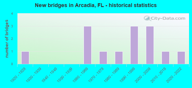
- New bridges - historical statistics
- 11920-1929
- 31960-1969
- 11970-1979
- 11980-1989
- 31990-1999
- 32000-2009
- 12010-2019
- 12020-2022

- Reconstructed bridges - Historical Statistics
- 21990-1999
- 02000-2009
- 12010-2019


- Bridge Condition - Deck
- 20.0%Very good
- 60.0%Good
- 20.0%Satisfactory

- Bridge Condition - Superstructure
- 10.0%Very good
- 80.0%Good
- 10.0%Poor

- Bridge Condition - Substructure
- 20.0%Very good
- 60.0%Good
- 10.0%Satisfactory
- 10.0%Poor

- Bridge Condition - Channel
- 7.7%Excellent
- 15.4%Very good
- 23.1%Good
- 38.5%Satisfactory
- 15.4%Fair
Find on map >> Show street view
Structure Number: 40002, Location: 1.2 MI W OF US-17 SR-35 (Lat: 27.223317, Lng: -81.883169), Route carried "on" structure: State highway 70, Year Built: 1961, Year Reconstructed: 1995, Status: Open, Structure Length: 17.07m (56.00ft), Average Daily Traffic: 13,500 (year 2020), Truck Traffic: 18%, Average Future Daily Traffic: 23,422 (year 2042), Design Load: HS 20, Features Intersected: PEACE RIVER RELIEF
Minimum Vertical Clearance: 30+ m (98+ ft), Kilometerpoint: 18.968, Lanes on structure: 2, Base Highway Network: Yes, Owner: State Highway Agency, Approaching Roadway Width: 13.6m (44.6ft), Material/Design: Prestressed concrete, Design/Construction: Stringer/Multi-beam, Number Of Spans In Main Unit: 14, Length of Maximum Span: 12.2m (40.0ft), Curb or Sidewalk Widths: Left: 1.9m (6.2ft), Right: 1.7m (5.6ft), Curb-To-Curb Width: 13.6m (44.6ft), Out-to-Out Width: 18.7m (61.4ft)
Condition: Deck: Good, Superstructure: Good, Substructure: Good, Channel: Very good, Operating Rating: 43.1 metric tons, Method Used To Determine Operating Rating: Load Factor (LF), Inventory Rating: 25.8 metric tons, Method Used To Determine Inventory Rating: Load Factor (LF), Structural Evaluation: Equal to present minimum criteria, Deck Geometry: Superior to present desirable criteria, Waterway Adequacy: Equal to present desirable criteria, Approach Roadway Alignment: Equal to present desirable criteria, Designated Inspection Frequency: Every 24 months, Inspection Date: May 2020, Deck Structure Type: Concrete Cast-file-Place
Find on map >> Show street view
Structure Number: 40023, Location: 1 MI W OF US-17/SR-35 (Lat: 27.221047, Lng: -81.876469), Route carried "on" structure: State highway 70, Year Built: 1961, Year Reconstructed: 1995, Status: Open, Structure Length: 8.53m (27.99ft), Average Daily Traffic: 13,500 (year 2020), Truck Traffic: 18%, Average Future Daily Traffic: 23,422 (year 2042), Design Load: HS 20, Features Intersected: PEACE RIVER
Minimum Vertical Clearance: 30+ m (98+ ft), Kilometerpoint: 19.731, Lanes on structure: 4, Base Highway Network: Yes, Owner: State Highway Agency, Approaching Roadway Width: 21.7m (71.2ft), Skew: 20 degrees, Material/Design: Prestressed concrete, Design/Construction: Stringer/Multi-beam, Number Of Spans In Main Unit: 7, Length of Maximum Span: 12.2m (40.0ft), Curb or Sidewalk Widths: Left: 1.9m (6.2ft), Right: 1.9m (6.2ft), Curb-To-Curb Width: 21.7m (71.2ft), Out-to-Out Width: 26.9m (88.3ft)
Condition: Deck: Good, Superstructure: Good, Substructure: Good, Channel: Satisfactory, Operating Rating: 43.1 metric tons, Method Used To Determine Operating Rating: Load Factor (LF), Inventory Rating: 25.8 metric tons, Method Used To Determine Inventory Rating: Load Factor (LF), Structural Evaluation: Equal to present minimum criteria, Deck Geometry: Superior to present desirable criteria, Waterway Adequacy: Equal to present desirable criteria, Approach Roadway Alignment: Equal to present desirable criteria, Designated Inspection Frequency: Every 24 months, Underwater Inspection Frequency: Every 24 months, Inspection Date: May 2020, Underwater Inspection Date: April 2020, Deck Structure Type: Concrete Cast-file-Place
Find on map >> Show street view
Structure Number: 40043, Location: 1.2 MI N OF SR-70 (Lat: 27.249433, Lng: -81.907900), Route carried "on" structure: County highway 661A, Year Built: 1960, Status: Open, Structure Length: 0.63m (2.07ft), Average Daily Traffic: 1,070 (year 2021), Truck Traffic: 1%, Average Future Daily Traffic: 1,857 (year 2042), Features Intersected: MUELLER CREEK
Minimum Vertical Clearance: 30+ m (98+ ft), Kilometerpoint: 2.028, Lanes on structure: 2, Owner: County Highway Agency, Approaching Roadway Width: 5.8m (19.0ft), Material/Design: Concrete, Design/Construction: Culvert, Number Of Spans In Main Unit: 2, Length of Maximum Span: 3.0m (9.8ft)
Condition: Channel: Satisfactory, Culverts: Good, Operating Rating: 78.4 metric tons, Method Used To Determine Operating Rating: Load Factor (LF), Inventory Rating: 47.0 metric tons, Method Used To Determine Inventory Rating: Load Factor (LF), Structural Evaluation: Better than present minimum criteria, Waterway Adequacy: Equal to present desirable criteria, Approach Roadway Alignment: Equal to present desirable criteria, Designated Inspection Frequency: Every 24 months, Underwater Inspection Frequency: Every 23 months, Inspection Date: January 2021, Underwater Inspection Date: January 2021
Find on map >> Show street view
Structure Number: 40044, Location: 0.8 MI N OF SR-70 (Lat: 27.239617, Lng: -81.891692), Route carried "on" structure: County highway 661, Year Built: 1979, Status: Open, Structure Length: 3.66m (12.01ft), Average Daily Traffic: 950 (year 2019), Truck Traffic: 20%, Average Future Daily Traffic: 1,649 (year 2041), Design Load: HS 20, Features Intersected: BUNKER CREEK
Minimum Vertical Clearance: 30+ m (98+ ft), Kilometerpoint: 1.276, Lanes on structure: 2, Owner: County Highway Agency, Approaching Roadway Width: 7.6m (24.9ft), Skew: 1 degrees, Material/Design: Prestressed concrete, Design/Construction: Slab, Number Of Spans In Main Unit: 4, Length of Maximum Span: 9.1m (29.9ft), Curb-To-Curb Width: 12.3m (40.4ft), Out-to-Out Width: 13.3m (43.6ft)
Condition: Deck: Good, Superstructure: Good, Substructure: Good, Channel: Excellent, Operating Rating: 57.0 metric tons, Method Used To Determine Operating Rating: Load Factor (LF), Inventory Rating: 35.4 metric tons, Method Used To Determine Inventory Rating: Load Factor (LF), Structural Evaluation: Better than present minimum criteria, Deck Geometry: Superior to present desirable criteria, Waterway Adequacy: Better than present minimum criteria, Approach Roadway Alignment: Equal to present desirable criteria, Designated Inspection Frequency: Every 24 months, Inspection Date: January 2021, Deck Structure Type: Concrete Precast Panels, Wearing Surface/Protective System: Wearing Surface: Bituminous
Find on map >> Show street view
Structure Number: 4006, Location: 5.4MI NORTH OF SR-70 (Lat: 27.287119, Lng: -81.828778), Route carried "on" structure: US 17, Year Built: 2005, Status: Open, Structure Length: 1.05m (3.44ft), Average Daily Traffic: 9,700 (year 2020), Truck Traffic: 21%, Average Future Daily Traffic: 16,830 (year 2042), Design Load: HS 25 or greater, Features Intersected: MARE BRANCH
Minimum Vertical Clearance: 30+ m (98+ ft), Kilometerpoint: 4.913, Lanes on structure: 5, Base Highway Network: Yes, Owner: State Highway Agency, Approaching Roadway Width: 25.0m (82.0ft), Skew: 12 degrees, Material/Design: Concrete, Design/Construction: Culvert, Number Of Spans In Main Unit: 3, Length of Maximum Span: 3.3m (10.8ft)
Condition: Channel: Good, Culverts: Good, Structural Evaluation: Better than present minimum criteria, Waterway Adequacy: Equal to present desirable criteria, Approach Roadway Alignment: Equal to present desirable criteria, Designated Inspection Frequency: Every 24 months, Inspection Date: May 2020
Find on map >> Show street view
Structure Number: 40063, Location: 0.5 MI N OF CR-760 (Lat: 27.166692, Lng: -81.879514), Route carried "on" structure: State highway 17, Year Built: 2015, Status: Open, Structure Length: 5.61m (18.41ft), Average Daily Traffic: 6,850 (year 2020), Truck Traffic: 18%, Average Future Daily Traffic: 11,885 (year 2042), Design Load: HL 93, Features Intersected: JOSHUA CREEK
Minimum Vertical Clearance: 30+ m (98+ ft), Kilometerpoint: 17.384, Lanes on structure: 2, Base Highway Network: Yes, Owner: State Highway Agency, Approaching Roadway Width: 9.9m (32.5ft), Material/Design: Prestressed concrete, Design/Construction: Stringer/Multi-beam, Number Of Spans In Main Unit: 3, Length of Maximum Span: 18.8m (61.7ft), Curb or Sidewalk Widths: Left: 1.5m (4.9ft), Right: 0.0m, Curb-To-Curb Width: 9.9m (32.5ft), Out-to-Out Width: 12.5m (41.0ft)
Condition: Deck: Very good, Superstructure: Very good, Substructure: Very good, Channel: Fair, Operating Rating: 53.5 metric tons, Method Used To Determine Operating Rating: Load and Resistance Factor (LRFR), Inventory Rating: 41.5 metric tons, Method Used To Determine Inventory Rating: Load and Resistance Factor (LRFR), Structural Evaluation: Equal to present desirable criteria, Deck Geometry: Meets minimum limits, Waterway Adequacy: Equal to present desirable criteria, Approach Roadway Alignment: Equal to present desirable criteria, Designated Inspection Frequency: Every 24 months, Inspection Date: Febuary 2022, Deck Structure Type: Concrete Cast-file-Place
Find on map >> Show street view
Structure Number: 44033, Location: 0.5 MI N OF SR-70 (Lat: 27.241572, Lng: -81.895750), Route carried "on" structure: County highway , Year Built: 1985, Year Reconstructed: 2018, Status: Posted for load-capacity, Structure Length: 1.68m (5.51ft), Average Daily Traffic: 200 (year 2021), Truck Traffic: 2%, Average Future Daily Traffic: 347 (year 2042), Design Load: HS 20, Features Intersected: BUNKER DITCH, Facility Carried by Structure: NW SECOND BUNKER
Minimum Vertical Clearance: 30+ m (98+ ft), Kilometerpoint: 2.028, Lanes on structure: 1, Owner: County Highway Agency, Approaching Roadway Width: 3.7m (12.1ft), Material/Design: Wood or Timber, Design/Construction: Stringer/Multi-beam, Number Of Spans In Main Unit: 4, Length of Maximum Span: 4.4m (14.4ft), Curb-To-Curb Width: 6.7m (22.0ft), Out-to-Out Width: 7.3m (24.0ft)
Condition: Deck: Good, Superstructure: Good, Substructure: Satisfactory, Channel: Satisfactory, Operating Rating: 44.0 metric tons, Method Used To Determine Operating Rating: Allowable Stress (AS), Inventory Rating: 32.7 metric tons, Method Used To Determine Inventory Rating: Allowable Stress (AS), Structural Evaluation: Equal to present minimum criteria, Deck Geometry: Meets minimum limits, Waterway Adequacy: Better than present minimum criteria, Approach Roadway Alignment: Better than present minimum criteria, Designated Inspection Frequency: Every 24 months, Underwater Inspection Frequency: Every 23 months, Inspection Date: January 2021, Underwater Inspection Date: January 2021, Deck Structure Type: Wood or Timber
Find on map >> Show street view
Structure Number: 4404, Location: 0.4 MI E OF CR-661A (Lat: 27.245611, Lng: -81.900033), Route carried "on" structure: County highway , Year Built: 1993, Status: Closed, Structure Length: 1.21m (3.97ft), Features Intersected: BONES CREEK, Facility Carried by Structure: OAK HILL CEMETERY
Minimum Vertical Clearance: 30+ m (98+ ft), Kilometerpoint: 0.000, Lanes on structure: 2, Owner: County Highway Agency, Approaching Roadway Width: 6.7m (22.0ft), Material/Design: Wood or Timber, Design/Construction: Stringer/Multi-beam, Number Of Spans In Main Unit: 3, Length of Maximum Span: 4.1m (13.5ft), Curb-To-Curb Width: 6.7m (22.0ft), Out-to-Out Width: 7.3m (24.0ft)
Condition: Deck: Satisfactory, Superstructure: Poor, Substructure: Poor, Channel: Satisfactory, Deck Geometry: Somewhat better than minimum adequacy, Waterway Adequacy: Better than present minimum criteria, Approach Roadway Alignment: Better than present minimum criteria, Bridge Posting: Required (Relationship of Operating Rating to Maximum Legal Load: > 39.9% below), Designated Inspection Frequency: Every 24 months, Underwater Inspection Frequency: Every 23 months, Other Special Inspection Frequency: Every 12 months, Inspection Date: January 2021, Underwater Inspection Date: January 2021, Other Special Inspection Date: January 2022, Deck Structure Type: Wood or Timber
Find on map >> Show street view
Structure Number: 44042, Location: 0.1 MI N OF CR-660 (Lat: 27.283633, Lng: -81.824356), Route carried "on" structure: County highway , Year Built: 1998, Status: Open, Structure Length: 1.40m (4.59ft), Average Daily Traffic: 200 (year 2021), Truck Traffic: 2%, Average Future Daily Traffic: 347 (year 2042), Design Load: HS 20+Mod, Features Intersected: MARE BRANCH, Facility Carried by Structure: NE MOORE AVE
Minimum Vertical Clearance: 30+ m (98+ ft), Kilometerpoint: 2.446, Lanes on structure: 2, Owner: County Highway Agency, Approaching Roadway Width: 7.3m (24.0ft), Material/Design: Concrete, Design/Construction: Tee Beam, Number Of Spans In Main Unit: 1, Length of Maximum Span: 14.0m (45.9ft), Curb-To-Curb Width: 7.3m (24.0ft), Out-to-Out Width: 8.2m (26.9ft)
Condition: Deck: Very good, Superstructure: Good, Substructure: Good, Channel: Good, Operating Rating: 78.7 metric tons, Method Used To Determine Operating Rating: Load Factor (LF), Inventory Rating: 47.3 metric tons, Method Used To Determine Inventory Rating: Load Factor (LF), Structural Evaluation: Better than present minimum criteria, Deck Geometry: Somewhat better than minimum adequacy, Waterway Adequacy: Better than present minimum criteria, Approach Roadway Alignment: Equal to present desirable criteria, Designated Inspection Frequency: Every 24 months, Inspection Date: January 2021, Deck Structure Type: Concrete Cast-file-Place
Find on map >> Show street view
Structure Number: 44044, Location: 0.3MI N/O NW GIRLSCOUT RD (Lat: 27.283086, Lng: -81.875317), Route carried "on" structure: County highway , Year Built: 2000, Status: Open, Structure Length: 1.32m (4.33ft), Average Daily Traffic: 40 (year 2021), Average Future Daily Traffic: 69 (year 2042), Design Load: HS 20, Features Intersected: WALKER BRANCH, Facility Carried by Structure: OAK HILL AVE.
Minimum Vertical Clearance: 30+ m (98+ ft), Kilometerpoint: 0.000, Lanes on structure: 2, Owner: County Highway Agency, Approaching Roadway Width: 5.5m (18.0ft), Material/Design: Wood or Timber, Design/Construction: Stringer/Multi-beam, Number Of Spans In Main Unit: 4, Length of Maximum Span: 3.4m (11.2ft), Curb-To-Curb Width: 5.5m (18.0ft), Out-to-Out Width: 6.1m (20.0ft)
Condition: Deck: Satisfactory, Superstructure: Good, Substructure: Good, Channel: Good, Operating Rating: 45.8 metric tons, Method Used To Determine Operating Rating: Allowable Stress (AS), Inventory Rating: 34.4 metric tons, Method Used To Determine Inventory Rating: Allowable Stress (AS), Structural Evaluation: Better than present minimum criteria, Deck Geometry: Meets minimum limits, Waterway Adequacy: Equal to present desirable criteria, Approach Roadway Alignment: Better than present minimum criteria, Designated Inspection Frequency: Every 24 months, Inspection Date: January 2021, Deck Structure Type: Wood or Timber
Find on map >> Show street view
Structure Number: 44045, Location: 0.4 MI WEST OF SR-31 (Lat: 27.184244, Lng: -81.838783), Route carried "on" structure: County highway , Year Built: 2001, Status: Open, Structure Length: 1.15m (3.77ft), Average Daily Traffic: 720 (year 2020), Truck Traffic: 3%, Average Future Daily Traffic: 12,492 (year 2040), Design Load: HS 25 or greater, Features Intersected: DURRANCE BRANCH, Facility Carried by Structure: DURRANCE STREET
Minimum Vertical Clearance: 30+ m (98+ ft), Kilometerpoint: 0.000, Lanes on structure: 2, Owner: County Highway Agency, Approaching Roadway Width: 6.3m (20.7ft), Material/Design: Concrete, Design/Construction: Culvert, Number Of Spans In Main Unit: 3, Length of Maximum Span: 3.7m (12.1ft)
Condition: Channel: Fair, Culverts: Good, Operating Rating: 40.7 metric tons, Method Used To Determine Operating Rating: Load and Resistance Factor (LRFR), Inventory Rating: 31.4 metric tons, Method Used To Determine Inventory Rating: Load and Resistance Factor (LRFR), Structural Evaluation: Better than present minimum criteria, Waterway Adequacy: Better than present minimum criteria, Approach Roadway Alignment: Better than present minimum criteria, Designated Inspection Frequency: Every 24 months, Inspection Date: May 2020
Find on map >> Show street view
Structure Number: 44046, Location: 1.5mi EAST OF US17 (Lat: 27.157736, Lng: -81.862156), Route carried "on" structure: County highway , Year Built: 2021, Status: Open, Structure Length: 2.87m (9.42ft), Average Daily Traffic: 250 (year 2021), Truck Traffic: 2%, Average Future Daily Traffic: 300 (year 2041), Design Load: HL 93, Features Intersected: HAWTHORNE CREEK, Facility Carried by Structure: REYNOLDS ST
Minimum Vertical Clearance: 30+ m (98+ ft), Kilometerpoint: 0.000, Lanes on structure: 2, Owner: County Highway Agency, Approaching Roadway Width: 6.2m (20.3ft), Material/Design: Concrete continuous, Design/Construction: Slab, Number Of Spans In Main Unit: 3, Length of Maximum Span: 11.0m (36.1ft), Curb-To-Curb Width: 8.6m (28.2ft), Out-to-Out Width: 9.3m (30.5ft)
Condition: Deck: Good, Superstructure: Good, Substructure: Very good, Channel: Very good, Operating Rating: 61.9 metric tons, Method Used To Determine Operating Rating: Load and Resistance Factor (LRFR), Inventory Rating: 47.7 metric tons, Method Used To Determine Inventory Rating: Load and Resistance Factor (LRFR), Structural Evaluation: Better than present minimum criteria, Deck Geometry: Equal to present minimum criteria, Waterway Adequacy: Equal to present desirable criteria, Approach Roadway Alignment: Equal to present desirable criteria, Designated Inspection Frequency: Every 24 months, Inspection Date: July 2021, Deck Structure Type: Concrete Cast-file-Place
Find on map >> Show street view
Structure Number: 134109, Location: 1.0MI S OF CLAY GULLY RD (Lat: 27.261061, Lng: -82.158044), Route carried "on" structure: County highway , Year Built: 1999, Status: Open, Structure Length: 0.91m (2.99ft), Average Daily Traffic: 42 (year 2020), Average Future Daily Traffic: 73 (year 2042), Design Load: HS 20, Features Intersected: BUD SLOUGH, Facility Carried by Structure: COKER GULLY ROAD
Minimum Vertical Clearance: 30+ m (98+ ft), Kilometerpoint: 0.000, Lanes on structure: 2, Owner: County Highway Agency, Approaching Roadway Width: 5.9m (19.4ft), Material/Design: Prestressed concrete, Design/Construction: Slab, Number Of Spans In Main Unit: 1, Length of Maximum Span: 9.1m (29.9ft), Curb-To-Curb Width: 7.7m (25.3ft), Out-to-Out Width: 8.6m (28.2ft)
Condition: Deck: Good, Superstructure: Good, Substructure: Good, Channel: Satisfactory, Operating Rating: 68.4 metric tons, Method Used To Determine Operating Rating: Load Factor (LF), Inventory Rating: 41.0 metric tons, Method Used To Determine Inventory Rating: Load Factor (LF), Structural Evaluation: Better than present minimum criteria, Deck Geometry: Equal to present minimum criteria, Waterway Adequacy: Equal to present minimum criteria, Approach Roadway Alignment: Equal to present desirable criteria, Designated Inspection Frequency: Every 24 months, Underwater Inspection Frequency: Every 23 months, Inspection Date: April 2020, Underwater Inspection Date: April 2020, Deck Structure Type: Concrete Precast Panels
Find on map >> Show street view
Structure Number: 49001, Location: 80FT W/O W. HICKORY ST (Lat: 27.222194, Lng: -81.876111), Route carried "under" structure: City street , Year Built: 1924, Structure Length: 0. m, Average Daily Traffic: 1 (year 2017), Features Intersected: PEACE RIVER, Facility Carried by Structure: AMERICAN LEGION DR
Minimum Vertical Clearance: 30+ m (98+ ft), Kilometerpoint: 0.650, Material/Design: Concrete, Design/Construction: Arch - Deck, Length of Maximum Span: 12.2m (40.0ft)