Bridge Statistics for Aptos, California (CA)
Condition, Traffic, Stress, Structural Evaluation, Project Costs
- National Bridge Inventory (NBI) Statistics
- 11Number of bridges
- 95ft / 29.0mTotal length
- 311,469Total average daily traffic
- 12,045Total average daily truck traffic
- National Bridge Inventory (NBI) Registered Bridges for Aptos
- No street view available for this location
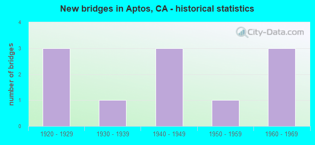
- New bridges - historical statistics
- 31920-1929
- 11930-1939
- 31940-1949
- 11950-1959
- 31960-1969


- Bridge Condition - Deck
- 40.0%Good
- 20.0%Satisfactory
- 40.0%Fair

- Bridge Condition - Superstructure
- 60.0%Good
- 20.0%Satisfactory
- 20.0%Fair

- Bridge Condition - Substructure
- 80.0%Good
- 20.0%Fair

- Bridge Condition - Channel
- 50.0%Good
- 25.0%Fair
- 25.0%Poor
Find on map >> Show street view
Structure Number: 36 0011, Location: 05-SCR-001-10.01 (Lat: 36.975167, Lng: -121.901828), Route carried "on" structure: State highway 1, Year Built: 1948, Status: Open, Structure Length: 7.92m (25.98ft), Average Daily Traffic: 78,000 (year 2019), Truck Traffic: 3%, Average Future Daily Traffic: 133,770 (year 2043), Design Load: HS 20, Features Intersected: APTOS CRK & SPRECKELS DR
Minimum Vertical Clearance: 30+ m (98+ ft), Kilometerpoint: 10.010, Lanes on structure: 4, Lanes under structure: 2, Base Highway Network: Yes (, Subroute: 1), Owner: State Highway Agency, Approaching Roadway Width: 20.7m (67.9ft), Skew: 30 degrees, Material/Design: Concrete continuous, Design/Construction: Tee Beam, Number Of Spans In Main Unit: 5, Length of Maximum Span: 17.1m (56.1ft), Curb-To-Curb Width: 16.8m (55.1ft), Out-to-Out Width: 18.5m (60.7ft)
Condition: Deck: Good, Superstructure: Good, Substructure: Good, Channel: Good, Operating Rating: 30.8 metric tons, Method Used To Determine Operating Rating: Load and Resistance Factor Rating (LRFR) rating reported by rating factor(RF) method using HL-93 loadings, Inventory Rating: 21.1 metric tons, Method Used To Determine Inventory Rating: Load and Resistance Factor Rating (LRFR) rating reported by rating factor(RF) method using HL-93 loadings, Structural Evaluation: Somewhat better than minimum adequacy, Deck Geometry: Meets minimum limits, Underclear: High priority of corrective action, Waterway Adequacy: Superior to present desirable criteria, Approach Roadway Alignment: Equal to present desirable criteria, Designated Inspection Frequency: Every 24 months, Inspection Date: July 2021, Deck Structure Type: Concrete Cast-file-Place, Wearing Surface/Protective System: Wearing Surface: Bituminous
Find on map >> Show street view
Structure Number: 36 0028, Location: 05-SCR-001-10.54 (Lat: 36.977678, Lng: -121.910592), Route carried "on" structure: County highway E197, Year Built: 1963, Status: Open, Structure Length: 6.46m (21.19ft), Average Daily Traffic: 16,200 (year 2019), Truck Traffic: 1%, Average Future Daily Traffic: 26,721 (year 2039), Design Load: HS 20, Features Intersected: STATE ROUTE 1, Facility Carried by Structure: STATE PARK DRIVE
Minimum Vertical Clearance: 30+ m (98+ ft), Kilometerpoint: 0.000, Lanes on structure: 2, Lanes under structure: 6, Owner: State Highway Agency, Approaching Roadway Width: 9.7m (31.8ft), Material/Design: Prestressed concrete continuous, Design/Construction: Stringer/Multi-beam, Number Of Spans In Main Unit: 2, Number Of Approach Spans: 2, Length of Maximum Span: 21.9m (71.9ft), Curb or Sidewalk Widths: Left: 1.5m (4.9ft), Right: 0.0m, Curb-To-Curb Width: 9.7m (31.8ft), Out-to-Out Width: 12.3m (40.4ft)
Condition: Deck: Fair, Superstructure: Good, Substructure: Good, Operating Rating: 36.6 metric tons, Method Used To Determine Operating Rating: Load and Resistance Factor Rating (LRFR) rating reported by rating factor(RF) method using HL-93 loadings, Inventory Rating: 26.9 metric tons, Method Used To Determine Inventory Rating: Load and Resistance Factor Rating (LRFR) rating reported by rating factor(RF) method using HL-93 loadings, Structural Evaluation: Equal to present minimum criteria, Deck Geometry: Meets minimum limits, Underclear: High priority of corrective action, Approach Roadway Alignment: Equal to present desirable criteria, Designated Inspection Frequency: Every 24 months, Inspection Date: July 2021, Deck Structure Type: Concrete Cast-file-Place
Find on map >> Show street view
Structure Number: 36C0075, Location: AT SPRECKLES DR (Lat: 36.976236, Lng: -121.904039), Route carried "on" structure: County highway , Year Built: 1928, Status: Open, Structure Length: 7.60m (24.93ft), Average Daily Traffic: 14,600 (year 2016), Truck Traffic: 10%, Average Future Daily Traffic: 15,915 (year 2041), Features Intersected: APTOS CREEK, Facility Carried by Structure: SOQUEL DR
Minimum Vertical Clearance: 30+ m (98+ ft), Kilometerpoint: 0.000, Lanes on structure: 2, Base Highway Network: Yes, Owner: County Highway Agency, Approaching Roadway Width: 7.3m (24.0ft), Skew: 9 degrees, Material/Design: Concrete, Design/Construction: Arch - Deck, Number Of Spans In Main Unit: 1, Number Of Approach Spans: 10, Length of Maximum Span: 41.1m (134.8ft), Curb or Sidewalk Widths: Left: 1.1m (3.6ft), Right: 1.1m (3.6ft), Curb-To-Curb Width: 7.3m (24.0ft), Out-to-Out Width: 10.1m (33.1ft)
Condition: Deck: Fair, Superstructure: Satisfactory, Substructure: Good, Channel: Fair, Operating Rating: 36.0 metric tons, Method Used To Determine Operating Rating: Load Factor (LF), Inventory Rating: 21.7 metric tons, Method Used To Determine Inventory Rating: Load Factor (LF), Structural Evaluation: Somewhat better than minimum adequacy, Deck Geometry: High priority of replacement, Waterway Adequacy: Equal to present desirable criteria, Approach Roadway Alignment: Meets minimum limits, Designated Inspection Frequency: Every 24 months, Inspection Date: September 2021, Deck Structure Type: Concrete Cast-file-Place
Find on map >> Show street view
Structure Number: 36C0116, Location: @ BEAR VALLEY ROAD (Lat: 36.996097, Lng: -121.866256), Route carried "on" structure: County highway , Year Built: 1935, Year Reconstructed: 2003, Status: Open, Structure Length: 4.77m (15.65ft), Average Daily Traffic: 3,000 (year 2016), Truck Traffic: 10%, Average Future Daily Traffic: 4,200 (year 2040), Features Intersected: VALENCIA CREEK, Facility Carried by Structure: VALENCIA RD
Minimum Vertical Clearance: 30+ m (98+ ft), Kilometerpoint: 0.000, Lanes on structure: 2, Owner: County Highway Agency, Approaching Roadway Width: 7.3m (24.0ft), Material/Design: Concrete continuous, Design/Construction: Tee Beam, Number Of Spans In Main Unit: 3, Length of Maximum Span: 27.3m (89.6ft), Curb or Sidewalk Widths: Left: 1.2m (3.9ft), Right: 0.2m (0.7ft), Curb-To-Curb Width: 7.3m (24.0ft), Out-to-Out Width: 9.3m (30.5ft)
Condition: Deck: Satisfactory, Superstructure: Good, Substructure: Good, Channel: Poor, Operating Rating: 44.7 metric tons, Method Used To Determine Operating Rating: Load Factor (LF), Inventory Rating: 26.9 metric tons, Method Used To Determine Inventory Rating: Load Factor (LF), Structural Evaluation: Equal to present minimum criteria, Deck Geometry: High priority of replacement, Waterway Adequacy: Superior to present desirable criteria, Approach Roadway Alignment: Equal to present minimum criteria, Designated Inspection Frequency: Every 24 months, Inspection Date: May 2020, Deck Structure Type: Concrete Cast-file-Place
Find on map >> Show street view
Structure Number: 36P0015, Location: FOREST OF NISENE MARKS SP (Lat: 37.001550, Lng: -121.906297), Route carried "on" structure: State lands road , Year Built: 1955, Status: Open, Structure Length: 2.23m (7.32ft), Average Daily Traffic: 200 (year 2015), Truck Traffic: 1%, Average Future Daily Traffic: 300 (year 2040), Features Intersected: APTOS CREEK, Facility Carried by Structure: APTOS CREEK ROAD
Minimum Vertical Clearance: 30+ m (98+ ft), Kilometerpoint: 0.000, Lanes on structure: 1, Owner: State Park, Forest, or Reservation Agency, Approaching Roadway Width: 4.6m (15.1ft), Material/Design: Steel, Design/Construction: Truss - Thru, Number Of Spans In Main Unit: 1, Length of Maximum Span: 21.3m (69.9ft), Curb or Sidewalk Widths: Left: 0.2m (0.7ft), Right: 0.2m (0.7ft), Curb-To-Curb Width: 3.4m (11.2ft), Out-to-Out Width: 3.8m (12.5ft)
Condition: Deck: Good, Superstructure: Fair, Substructure: Fair, Channel: Good, Operating Rating: 28.2 metric tons, Method Used To Determine Operating Rating: Load Factor (LF), Inventory Rating: 16.8 metric tons, Method Used To Determine Inventory Rating: Load Factor (LF), Structural Evaluation: Somewhat better than minimum adequacy, Deck Geometry: High priority of replacement, Waterway Adequacy: Equal to present desirable criteria, Approach Roadway Alignment: Equal to present minimum criteria, Designated Inspection Frequency: Every 24 months, Critical Feature Inspection Frequency: Every 24 months, Inspection Date: September 2021, Critical Feature Inspection Date: April 2021, Deck Structure Type: Wood or Timber, Wearing Surface/Protective System: Wearing Surface: Wood or Timber
Find on map >> Show street view
Structure Number: 36 0011, Location: 05-SCR-001-10.01 (Lat: 36.975167, Lng: -121.901828), Route carried "under" structure: County highway E199, Year Built: 1948, Structure Length: 0. m, Average Daily Traffic: 560 (year 2017), Truck Traffic: 2%, Features Intersected: APTOS CRK & SPRECKELS DR, Facility Carried by Structure: STATE ROUTE 1
Minimum Vertical Clearance: 4.67m (15.32ft), Kilometerpoint: 0.000, Lanes on structure: 4, Lanes under structure: 2, Material/Design: Concrete continuous, Design/Construction: Tee Beam, Length of Maximum Span: 17.1m (56.1ft)
Find on map >> Show street view
Structure Number: 36 0012, Location: 05-SCR-001-10.23 (Lat: 36.975594, Lng: -121.906039), Route carried "under" structure: State highway 1, Year Built: 1948, Structure Length: 0. m, Average Daily Traffic: 78,000 (year 2009), Truck Traffic: 3%, Features Intersected: STATE ROUTE 1, Facility Carried by Structure: UP RR
Minimum Vertical Clearance: 4.72m (15.49ft), Kilometerpoint: 10.230, Lanes under structure: 4, Material/Design: Steel, Design/Construction: Girder and Floorbeam System, Length of Maximum Span: 20.4m (66.9ft)
Find on map >> Show street view
Structure Number: 36 0028, Location: 05-SCR-001-10.54 (Lat: 36.977678, Lng: -121.910592), Route carried "under" structure: State highway 1, Year Built: 1963, Structure Length: 0. m, Average Daily Traffic: 78,000 (year 2019), Truck Traffic: 3%, Features Intersected: STATE ROUTE 1, Facility Carried by Structure: STATE PARK DRIVE
Minimum Vertical Clearance: 4.74m (15.55ft), Kilometerpoint: 10.540, Lanes on structure: 2, Lanes under structure: 6, Material/Design: Prestressed concrete continuous, Design/Construction: Stringer/Multi-beam, Length of Maximum Span: 21.9m (71.9ft)
Find on map >> Show street view
Structure Number: 36C0069, Location: W APTOS ST (Lat: 36.975919, Lng: -121.898778), Route carried "under" structure: County highway , Year Built: 1924, Structure Length: 0. m, Average Daily Traffic: 15,000 (year 2017), Truck Traffic: 2%, Features Intersected: SOQUEL DR, Facility Carried by Structure: UP RR
Minimum Vertical Clearance: 4.31m (14.14ft), Kilometerpoint: 0.000, Lanes under structure: 2, Material/Design: Steel, Design/Construction: Stringer/Multi-beam, Length of Maximum Span: 18.0m (59.1ft)
Find on map >> Show street view
Structure Number: 36C0077, Location: AT INTRX W/SPRECKLES DR (Lat: 36.976289, Lng: -121.904283), Route carried "under" structure: County highway , Year Built: 1929, Structure Length: 0. m, Average Daily Traffic: 12,909 (year 1980), Truck Traffic: 10%, Features Intersected: SOQUEL DR, Facility Carried by Structure: UP RR
Minimum Vertical Clearance: 4.46m (14.63ft), Kilometerpoint: 0.000, Lanes under structure: 2, Material/Design: Steel, Design/Construction: Girder and Floorbeam System, Length of Maximum Span: 21.0m (68.9ft)
Find on map >> Show street view
Structure Number: 36C0103, Location: 3.7 MI E OF SR 1 (Lat: 36.987919, Lng: -121.924294), Route carried "under" structure: County highway , Year Built: 1962, Structure Length: 0. m, Average Daily Traffic: 15,000 (year 2008), Truck Traffic: 10%, Features Intersected: SOQUEL DR, Facility Carried by Structure: PEDESTRIAN WALKWAY
Minimum Vertical Clearance: 4.67m (15.32ft), Kilometerpoint: 0.000, Lanes under structure: 4, Material/Design: Steel, Design/Construction: Stringer/Multi-beam, Length of Maximum Span: 14.9m (48.9ft)