Bridge Statistics for Annapolis, Maryland (MD)
Condition, Traffic, Stress, Structural Evaluation, Project Costs
- National Bridge Inventory (NBI) Statistics
- 12Number of bridges
- 686ft / 209mTotal length
- $2,369,000Total costs
- 451,083Total average daily traffic
- 28,323Total average daily truck traffic
- National Bridge Inventory (NBI) Registered Bridges for Annapolis
- No street view available for this location
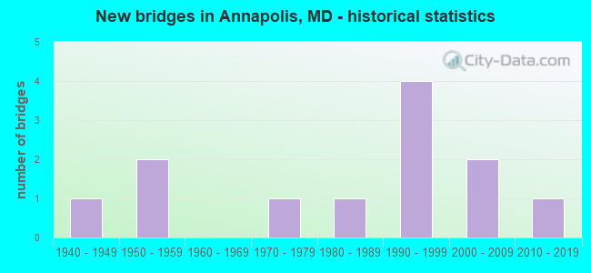
- New bridges - historical statistics
- 11940-1949
- 21950-1959
- 11970-1979
- 11980-1989
- 41990-1999
- 22000-2009
- 12010-2019

- Reconstructed bridges - Historical Statistics
- 11980-1989
- 01990-1999
- 12000-2009


- Bridge Condition - Deck
- 77.8%Good
- 11.1%Satisfactory
- 11.1%Fair

- Bridge Condition - Superstructure
- 11.1%Very good
- 55.6%Good
- 11.1%Satisfactory
- 22.2%Fair

- Bridge Condition - Substructure
- 11.1%Very good
- 44.4%Good
- 44.4%Satisfactory

- Bridge Condition - Channel
- 55.6%Very good
- 22.2%Good
- 22.2%Satisfactory

- Bridge Condition - Culverts
- 50.0%Good
- 50.0%Satisfactory
Find on map >> Show street view
Structure Number: 1MD0641, Location: 0.5 KM SE OF RT. 450 (Lat: 38.986028, Lng: -76.491694), Route carried "on" structure: Other road , Year Built: 1983, Status: Open, Structure Length: 15.22m (49.93ft), Average Daily Traffic: 4,400 (year 2005), Truck Traffic: 5%, Average Future Daily Traffic: 5,500 (year 2035), Design Load: HS 20, Features Intersected: DORSEY CREEK, Facility Carried by Structure: DECATUR ROAD
Minimum Vertical Clearance: 30+ m (98+ ft), Kilometerpoint: 0.000, Lanes on structure: 2, Owner: Navy/Marines, Approaching Roadway Width: 8.2m (26.9ft), Material/Design: Prestressed concrete, Design/Construction: Stringer/Multi-beam, Number Of Spans In Main Unit: 8, Length of Maximum Span: 19.0m (62.3ft), Curb or Sidewalk Widths: Left: 1.5m (4.9ft), Right: 0.0m, Curb-To-Curb Width: 8.2m (26.9ft), Out-to-Out Width: 11.0m (36.1ft)
Condition: Deck: Satisfactory, Superstructure: Fair, Substructure: Satisfactory, Channel: Very good, Operating Rating: 92.0 metric tons, Method Used To Determine Operating Rating: Load and Resistance Factor (LRFR), Inventory Rating: 71.1 metric tons, Method Used To Determine Inventory Rating: Load and Resistance Factor (LRFR), Structural Evaluation: Somewhat better than minimum adequacy, Deck Geometry: High priority of corrective action, Waterway Adequacy: Equal to present desirable criteria, Approach Roadway Alignment: Equal to present desirable criteria, Length Of Structure Improvement: 15.22m (49.93ft), Designated Inspection Frequency: Every 24 months, Underwater Inspection Frequency: Every 60 months, Inspection Date: June 2021, Underwater Inspection Date: June 2019, Bridge Improvement Cost: $105,000, Roadway Improvement Cost: $25,000, Total Project Cost: $130,000 ( Estimate for 2021), Deck Structure Type: Concrete Cast-file-Place
Find on map >> Show street view
Structure Number: 1MD0642, Location: 0.3 KM E OF DECATUR AVE (Lat: 38.985397, Lng: -76.486683), Route carried "on" structure: Other road , Year Built: 2011, Status: Open, Structure Length: 7.15m (23.46ft), Average Daily Traffic: 4,400 (year 2005), Truck Traffic: 5%, Average Future Daily Traffic: 5,500 (year 2035), Design Load: HS 20+Mod, Features Intersected: DORSEY CREEK, Facility Carried by Structure: MCNAIR ROAD
Minimum Vertical Clearance: 30+ m (98+ ft), Kilometerpoint: 0.000, Lanes on structure: 2, Owner: Navy/Marines, Approaching Roadway Width: 6.7m (22.0ft), Skew: 9 degrees, Material/Design: Prestressed concrete, Design/Construction: Slab, Number Of Spans In Main Unit: 6, Number Of Approach Spans: 1, Length of Maximum Span: 12.7m (41.7ft), Curb or Sidewalk Widths: Left: 2.6m (8.5ft), Right: 1.9m (6.2ft), Curb-To-Curb Width: 6.7m (22.0ft), Out-to-Out Width: 11.5m (37.7ft)
Condition: Deck: Good, Superstructure: Very good, Substructure: Very good, Channel: Very good, Operating Rating: 95.0 metric tons, Method Used To Determine Operating Rating: Load and Resistance Factor (LRFR), Inventory Rating: 73.1 metric tons, Method Used To Determine Inventory Rating: Load and Resistance Factor (LRFR), Structural Evaluation: Equal to present desirable criteria, Deck Geometry: High priority of replacement, Waterway Adequacy: Better than present minimum criteria, Approach Roadway Alignment: Equal to present desirable criteria, Length Of Structure Improvement: 7.15m (23.46ft), Designated Inspection Frequency: Every 24 months, Underwater Inspection Frequency: Every 60 months, Inspection Date: June 2021, Underwater Inspection Date: June 2019, Bridge Improvement Cost: $20,000, Roadway Improvement Cost: $55,000, Total Project Cost: $75,000 ( Estimate for 2021), Deck Structure Type: Concrete Cast-file-Place, Wearing Surface/Protective System: Wearing Surface: Monolithic Concrete, Deck Protection: Epoxy Coated Reinforcing
Find on map >> Show street view
Structure Number: 10000002003101, Location: 0.73 MI W OF IS 97 (Lat: 0.000108, Lng: -0.000019), Route carried "on" structure: Interstate 595, Year Built: 1950, Year Reconstructed: 1993, Status: Open, Structure Length: 1.92m (6.30ft), Average Daily Traffic: 101,670 (year 2009), Truck Traffic: 7%, Average Future Daily Traffic: 166,110 (year 2029), Design Load: HS 20, Features Intersected: SOUTH HAVEN ROAD
Minimum Vertical Clearance: 30+ m (98+ ft), Kilometerpoint: 9.976, Lanes on structure: 6, Lanes under structure: 2, Base Highway Network: Yes, Owner: State Highway Agency, Approaching Roadway Width: 39.6m (129.9ft), Skew: 33 degrees, Material/Design: Steel, Design/Construction: Stringer/Multi-beam, Number Of Spans In Main Unit: 1, Length of Maximum Span: 19.2m (63.0ft), Curb-To-Curb Width: 38.7m (127.0ft), Out-to-Out Width: 40.8m (133.9ft)
Condition: Deck: Good, Superstructure: Good, Substructure: Satisfactory, Inventory Rating: 60.8 metric tons, Method Used To Determine Inventory Rating: Load Factor (LF), Structural Evaluation: Equal to present minimum criteria, Deck Geometry: Superior to present desirable criteria, Underclear: Better than present minimum criteria, Approach Roadway Alignment: Equal to present desirable criteria, Designated Inspection Frequency: Every 24 months, Inspection Date: January 2020, Deck Structure Type: Concrete Cast-file-Place, Wearing Surface/Protective System: Wearing Surface: Monolithic Concrete, Deck Protection: Epoxy Coated Reinforcing
Find on map >> Show street view
Structure Number: 10000002004201, Location: 0.37 MI S OF IS 595 (Lat: 38.990528, Lng: -76.508256), Route carried "on" structure: State highway 70, Year Built: 2006, Status: Open, Structure Length: 21.70m (71.19ft), Average Daily Traffic: 38,762 (year 2009), Truck Traffic: 2%, Average Future Daily Traffic: 58,143 (year 2029), Design Load: HS 25 or greater, Features Intersected: WEEMS CREEK
Minimum Vertical Clearance: 30+ m (98+ ft), Kilometerpoint: 1.995, Lanes on structure: 4, Lanes under structure: 2, Owner: State Highway Agency, Approaching Roadway Width: 15.9m (52.2ft), Skew: 20 degrees, Navigation Control: Yes ( Vertical Clearance: 8.5m (27.9ft), Horizontal Clearance: 42.7m (140.1ft)), Material/Design: Steel continuous, Design/Construction: Stringer/Multi-beam, Number Of Spans In Main Unit: 5, Length of Maximum Span: 54.9m (180.1ft), Curb or Sidewalk Widths: Left: 1.6m (5.2ft), Right: 0.0m, Curb-To-Curb Width: 15.9m (52.2ft), Out-to-Out Width: 23.0m (75.5ft)
Condition: Deck: Good, Superstructure: Good, Substructure: Good, Channel: Very good, Inventory Rating: 61.2 metric tons, Method Used To Determine Inventory Rating: Load Factor (LF), Structural Evaluation: Better than present minimum criteria, Deck Geometry: Meets minimum limits, Underclear: High priority of corrective action, Waterway Adequacy: Superior to present desirable criteria, Approach Roadway Alignment: Equal to present desirable criteria, Designated Inspection Frequency: Every 24 months, Underwater Inspection Frequency: Every 48 months, Inspection Date: April 2021, Underwater Inspection Date: January 2020, Deck Structure Type: Concrete Cast-file-Place, Wearing Surface/Protective System: Wearing Surface: Integral Concrete, Deck Protection: Epoxy Coated Reinforcing
Find on map >> Show street view
Structure Number: 10000002004301, Location: 0.42 MI S OF MD 435 (Lat: 38.984083, Lng: -76.498139), Route carried "on" structure: State highway 70, Year Built: 1954, Year Reconstructed: 2006, Status: Open, Structure Length: 28.41m (93.21ft), Average Daily Traffic: 38,762 (year 2009), Truck Traffic: 2%, Average Future Daily Traffic: 47,091 (year 2026), Design Load: HS 20, Features Intersected: COLLEGE CREEK
Minimum Vertical Clearance: 30+ m (98+ ft), Kilometerpoint: 0.595, Lanes on structure: 4, Owner: State Highway Agency, Approaching Roadway Width: 16.5m (54.1ft), Skew: 20 degrees, Material/Design: Steel, Design/Construction: Stringer/Multi-beam, Number Of Spans In Main Unit: 16, Length of Maximum Span: 17.7m (58.1ft), Curb or Sidewalk Widths: Left: 2.2m (7.2ft), Right: 2.2m (7.2ft), Curb-To-Curb Width: 16.5m (54.1ft), Out-to-Out Width: 23.0m (75.5ft)
Condition: Deck: Good, Superstructure: Good, Substructure: Satisfactory, Channel: Very good, Operating Rating: 79.8 metric tons, Method Used To Determine Operating Rating: Load Factor (LF), Inventory Rating: 47.6 metric tons, Method Used To Determine Inventory Rating: Load Factor (LF), Structural Evaluation: Equal to present minimum criteria, Deck Geometry: Meets minimum limits, Waterway Adequacy: Equal to present desirable criteria, Approach Roadway Alignment: Equal to present desirable criteria, Designated Inspection Frequency: Every 24 months, Underwater Inspection Frequency: Every 48 months, Inspection Date: June 2021, Underwater Inspection Date: July 2021, Deck Structure Type: Concrete Cast-file-Place, Wearing Surface/Protective System: Wearing Surface: Integral Concrete, Deck Protection: Epoxy Coated Reinforcing
Find on map >> Show street view
Structure Number: 10000002005301, Location: ANNAPOLIS MD. (Lat: 38.972669, Lng: -76.485503), Route carried "on" structure: City street 2920, Year Built: 1946, Status: Open, Structure Length: 25.36m (83.20ft), Average Daily Traffic: 19,251 (year 2009), Truck Traffic: 5%, Average Future Daily Traffic: 28,877 (year 2029), Design Load: H 20, Features Intersected: SPA CREEK, Facility Carried by Structure: MD 181(SIXTH ST)
Minimum Vertical Clearance: 30+ m (98+ ft), Kilometerpoint: 0.129, Lanes on structure: 2, Base Highway Network: Yes, Owner: State Highway Agency, Approaching Roadway Width: 11.0m (36.1ft), Navigation Control: Yes ( Vertical Clearance: 5.2m (17.1ft), Horizontal Clearance: 12.2m (40.0ft)), Material/Design: Steel, Design/Construction: Movable - Bascule, Number Of Spans In Main Unit: 1, Number Of Approach Spans: 14, Length of Maximum Span: 18.9m (62.0ft), Curb or Sidewalk Widths: Left: 1.9m (6.2ft), Right: 1.9m (6.2ft), Curb-To-Curb Width: 7.9m (25.9ft), Out-to-Out Width: 11.9m (39.0ft)
Condition: Deck: Fair, Superstructure: Fair, Substructure: Satisfactory, Channel: Very good, Operating Rating: 35.8 metric tons, Method Used To Determine Operating Rating: Load Factor (LF), Inventory Rating: 24.0 metric tons, Method Used To Determine Inventory Rating: Load Factor (LF), Structural Evaluation: Somewhat better than minimum adequacy, Deck Geometry: High priority of corrective action, Waterway Adequacy: Superior to present desirable criteria, Approach Roadway Alignment: Equal to present minimum criteria, Length Of Structure Improvement: 25.36m (83.20ft), Designated Inspection Frequency: Every 24 months, Critical Feature Inspection Frequency: Every 24 months, Underwater Inspection Frequency: Every 48 months, Other Special Inspection Frequency: Every 24 months, Inspection Date: Febuary 2020, Critical Feature Inspection Date: Febuary 2020, Underwater Inspection Date: July 2021, Other Special Inspection Date: Febuary 2020, Bridge Improvement Cost: $1,957,000, Roadway Improvement Cost: $196,000, Total Project Cost: $2,153,000, Deck Structure Type: Concrete Cast-file-Place, Wearing Surface/Protective System: Wearing Surface: Latex Concrete
Find on map >> Show street view
Structure Number: 10000002007001, Location: 0.31 MI W OF MD 648A (Lat: 38.991333, Lng: -76.491722), Route carried "on" structure: State highway 450, Year Built: 1995, Status: Open, Structure Length: 86.41m (283.50ft), Average Daily Traffic: 18,874 (year 2017), Truck Traffic: 6%, Average Future Daily Traffic: 20,908 (year 2034), Design Load: HS 25 or greater, Features Intersected: SEVERN RIVER
Minimum Vertical Clearance: 30+ m (98+ ft), Kilometerpoint: 22.671, Lanes on structure: 2, Base Highway Network: Yes, Owner: State Highway Agency, Approaching Roadway Width: 17.4m (57.1ft), Navigation Control: Yes ( Vertical Clearance: 22.9m (75.1ft), Horizontal Clearance: 42.7m (140.1ft)), Material/Design: Steel continuous, Design/Construction: Box Beam or Girders - Multiple, Number Of Spans In Main Unit: 17, Length of Maximum Span: 96.0m (315.0ft), Curb or Sidewalk Widths: Left: 1.5m (4.9ft), Right: 1.5m (4.9ft), Curb-To-Curb Width: 12.5m (41.0ft), Out-to-Out Width: 16.8m (55.1ft)
Condition: Deck: Good, Superstructure: Satisfactory, Substructure: Good, Channel: Satisfactory, Operating Rating: 41.3 metric tons, Method Used To Determine Operating Rating: Load Factor (LF), Inventory Rating: 24.5 metric tons, Method Used To Determine Inventory Rating: Load Factor (LF), Structural Evaluation: Equal to present minimum criteria, Deck Geometry: Somewhat better than minimum adequacy, Waterway Adequacy: Superior to present desirable criteria, Approach Roadway Alignment: Equal to present desirable criteria, Designated Inspection Frequency: Every 24 months, Critical Feature Inspection Frequency: Every 24 months, Underwater Inspection Frequency: Every 48 months, Inspection Date: January 2020, Critical Feature Inspection Date: January 2020, Underwater Inspection Date: July 2021, Deck Structure Type: Concrete Cast-file-Place, Wearing Surface/Protective System: Wearing Surface: Monolithic Concrete, Deck Protection: Epoxy Coated Reinforcing
Find on map >> Show street view
Structure Number: 10000002008101, Location: 0.35 MILE SOUTH OF IS 595 (Lat: 38.993072, Lng: -76.508592), Route carried "on" structure: State highway 436, Year Built: 1997, Status: Open, Structure Length: 11.13m (36.52ft), Average Daily Traffic: 5,110 (year 2009), Truck Traffic: 2%, Average Future Daily Traffic: 6,180 (year 2026), Design Load: HS 25 or greater, Features Intersected: WEEMS CREEK
Minimum Vertical Clearance: 30+ m (98+ ft), Kilometerpoint: 0.756, Lanes on structure: 2, Owner: State Highway Agency, Approaching Roadway Width: 7.3m (24.0ft), Navigation Control: Yes ( Vertical Clearance: 2.1m (6.9ft), Horizontal Clearance: 8.5m (27.9ft)), Material/Design: Steel, Design/Construction: Movable - Swing, Number Of Spans In Main Unit: 2, Number Of Approach Spans: 3, Length of Maximum Span: 26.5m (86.9ft), Curb or Sidewalk Widths: Left: 1.5m (4.9ft), Right: 0.0m, Curb-To-Curb Width: 9.1m (29.9ft), Out-to-Out Width: 11.7m (38.4ft)
Condition: Deck: Good, Superstructure: Good, Substructure: Good, Channel: Good, Inventory Rating: 55.3 metric tons, Method Used To Determine Inventory Rating: Load Factor (LF), Structural Evaluation: Better than present minimum criteria, Deck Geometry: Meets minimum limits, Waterway Adequacy: Equal to present desirable criteria, Approach Roadway Alignment: Better than present minimum criteria, Designated Inspection Frequency: Every 24 months, Underwater Inspection Frequency: Every 48 months, Other Special Inspection Frequency: Every 24 months, Inspection Date: March 2021, Underwater Inspection Date: May 2020, Other Special Inspection Date: March 2021, Deck Structure Type: Concrete Cast-file-Place
Find on map >> Show street view
Structure Number: 10000002015901, Location: 1.77 MI W OF MD 450 (Lat: 38.984231, Lng: -76.578783), Route carried "on" structure: Ramp Interstate 595, Year Built: 1994, Status: Open, Structure Length: 9.75m (31.99ft), Average Daily Traffic: 101,670 (year 2009), Truck Traffic: 8%, Average Future Daily Traffic: 166,110 (year 2029), Design Load: HS 20, Features Intersected: IS 595
Minimum Vertical Clearance: 30+ m (98+ ft), Kilometerpoint: 10.829, Lanes on structure: 1, Lanes under structure: 6, Base Highway Network: Yes, Owner: State Highway Agency, Approaching Roadway Width: 10.7m (35.1ft), Skew: 5 degrees, Material/Design: Steel continuous, Design/Construction: Stringer/Multi-beam, Number Of Spans In Main Unit: 2, Length of Maximum Span: 53.0m (173.9ft), Curb-To-Curb Width: 8.8m (28.9ft), Out-to-Out Width: 10.4m (34.1ft)
Condition: Deck: Good, Superstructure: Good, Substructure: Good, Operating Rating: 67.6 metric tons, Method Used To Determine Operating Rating: Load Factor (LF), Inventory Rating: 40.4 metric tons, Method Used To Determine Inventory Rating: Load Factor (LF), Structural Evaluation: Better than present minimum criteria, Deck Geometry: Superior to present desirable criteria, Underclear: Equal to present minimum criteria, Approach Roadway Alignment: Equal to present desirable criteria, Designated Inspection Frequency: Every 24 months, Inspection Date: April 2021, Deck Structure Type: Concrete Cast-file-Place, Wearing Surface/Protective System: Wearing Surface: Monolithic Concrete, Deck Protection: Epoxy Coated Reinforcing
Find on map >> Show street view
Structure Number: 200000AA200801, Location: ANNE ARUNDEL MEDICAL PARK (Lat: 38.992003, Lng: -76.549064), Route carried "on" structure: Alternate County highway 5826, Year Built: 2002, Status: Open, Structure Length: 1.59m (5.22ft), Average Daily Traffic: 8,484 (year 2016), Truck Traffic: 10%, Average Future Daily Traffic: 7,200 (year 2030), Design Load: HS 25 or greater, Features Intersected: COWHIDE BRANCH, Facility Carried by Structure: MEDICAL PARKWAY
Minimum Vertical Clearance: 30+ m (98+ ft), Kilometerpoint: 0.002, Lanes on structure: 5, Owner: County Highway Agency, Approaching Roadway Width: 20.1m (65.9ft), Skew: 20 degrees, Material/Design: Steel, Design/Construction: Culvert, Number Of Spans In Main Unit: 1, Length of Maximum Span: 15.9m (52.2ft), Curb or Sidewalk Widths: Left: 2.7m (8.9ft), Right: 1.2m (3.9ft), Curb-To-Curb Width: 20.0m (65.6ft), Out-to-Out Width: 36.6m (120.1ft)
Condition: Channel: Good, Culverts: Good, Operating Rating: 63.0 metric tons, Method Used To Determine Operating Rating: Load Factor (LF), Inventory Rating: 52.6 metric tons, Method Used To Determine Inventory Rating: Load Factor (LF), Structural Evaluation: Better than present minimum criteria, Deck Geometry: Somewhat better than minimum adequacy, Waterway Adequacy: Equal to present desirable criteria, Approach Roadway Alignment: Equal to present desirable criteria, Designated Inspection Frequency: Every 24 months, Inspection Date: November 2021
Find on map >> Show street view
Structure Number: 200000AAA-0102, Location: 0.5 MI N OF FOREST DRIVE (Lat: 38.971550, Lng: -76.510300), Route carried "on" structure: City street 387, Year Built: 1970, Status: Open, Structure Length: 0.70m (2.30ft), Average Daily Traffic: 18,400 (year 2018), Truck Traffic: 4%, Average Future Daily Traffic: 22,300 (year 2040), Design Load: HS 20, Features Intersected: SPA CREEK, Facility Carried by Structure: SPA ROAD
Minimum Vertical Clearance: 30+ m (98+ ft), Kilometerpoint: 0.000, Lanes on structure: 2, Owner: City or Municipal Highway Agency, Approaching Roadway Width: 7.3m (24.0ft), Skew: 1 degrees, Material/Design: Concrete, Design/Construction: Culvert, Length of Maximum Span: 3.0m (9.8ft), Curb or Sidewalk Widths: Left: 1.2m (3.9ft), Right: 1.2m (3.9ft)
Condition: Channel: Satisfactory, Culverts: Satisfactory, Operating Rating: 58.0 metric tons, Method Used To Determine Operating Rating: Load Factor (LF), Inventory Rating: 34.9 metric tons, Method Used To Determine Inventory Rating: Load Factor (LF), Structural Evaluation: Equal to present minimum criteria, Waterway Adequacy: Equal to present desirable criteria, Approach Roadway Alignment: Equal to present desirable criteria, Length Of Structure Improvement: 0.67m (2.20ft), Designated Inspection Frequency: Every 24 months, Inspection Date: March 2020, Bridge Improvement Cost: $10,000, Roadway Improvement Cost: $1,000, Total Project Cost: $11,000
Find on map >> Show street view
Structure Number: 10000002015901, Location: 0.2 MILE WEST OF IS 97 (Lat: 38.984231, Lng: -76.578783), Route carried "under" structure: Interstate 595, Year Built: 1994, Structure Length: 0. m, Average Daily Traffic: 91,300 (year 2009), Truck Traffic: 8%, Features Intersected: IS 595
Minimum Vertical Clearance: 5.18m (16.99ft), Kilometerpoint: 10.829, Lanes on structure: 1, Lanes under structure: 6, Material/Design: Steel continuous, Design/Construction: Stringer/Multi-beam, Length of Maximum Span: 53.0m (173.9ft)