Bridge Statistics for Americus, Georgia (GA)
Condition, Traffic, Stress, Structural Evaluation, Project Costs
- National Bridge Inventory (NBI) Statistics
- 32Number of bridges
- 404ft / 123mTotal length
- $25,220,000Total costs
- 130,130Total average daily traffic
- 4,053Total average daily truck traffic
- National Bridge Inventory (NBI) Registered Bridges for Americus
- No street view available for this location
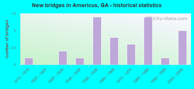
- New bridges - historical statistics
- 11910-1919
- 21930-1939
- 11940-1949
- 71950-1959
- 41960-1969
- 31970-1979
- 71980-1989
- 11990-1999
- 52000-2009

- Reconstructed bridges - Historical Statistics
- 31980-1989
- 11990-1999
- 22000-2009


- Bridge Condition - Deck
- 4.8%Very good
- 85.7%Good
- 4.8%Satisfactory
- 4.8%Fair

- Bridge Condition - Superstructure
- 19.0%Very good
- 76.2%Good
- 4.8%Fair

- Bridge Condition - Substructure
- 4.8%Very good
- 90.5%Good
- 4.8%Satisfactory

- Bridge Condition - Channel
- 24.0%Very good
- 52.0%Good
- 12.0%Satisfactory
- 12.0%Fair
Find on map >> Show street view
Structure Number: 2495006, Location: 6 MI SE OF ELLAVILLE (Lat: 32.160819, Lng: -84.238747), Route carried "on" structure: County highway 1804, Year Built: 1995, Status: Open, Structure Length: 0.64m (2.10ft), Average Daily Traffic: 260 (year 2011), Truck Traffic: 1%, Average Future Daily Traffic: 390 (year 2031), Design Load: HS 20+Mod, Features Intersected: SWEETWATER CREEK TRIB, Facility Carried by Structure: LA CROSSE RD.
Minimum Vertical Clearance: 30+ m (98+ ft), Kilometerpoint: 0.000, Lanes on structure: 2, Base Highway Network: Yes, Owner: County Highway Agency, Approaching Roadway Width: 6.1m (20.0ft), Material/Design: Concrete, Design/Construction: Culvert, Number Of Spans In Main Unit: 2, Length of Maximum Span: 3.0m (9.8ft)
Condition: Channel: Satisfactory, Culverts: Good, Operating Rating: 54.4 metric tons, Method Used To Determine Operating Rating: Field evaluation and documented engineering judgment, Inventory Rating: 32.6 metric tons, Method Used To Determine Inventory Rating: Field evaluation and documented engineering judgment, Structural Evaluation: Better than present minimum criteria, Waterway Adequacy: Somewhat better than minimum adequacy, Approach Roadway Alignment: Better than present minimum criteria, Designated Inspection Frequency: Every 24 months, Underwater Inspection Frequency: Every 60 months, Inspection Date: March 2021, Underwater Inspection Date: March 2019
Find on map >> Show street view
Structure Number: 2610004, Location: IN SW AMERICUS (Lat: 32.070578, Lng: -84.248003), Route carried "on" structure: US 19, Year Built: 1972, Year Reconstructed: 2009, Status: Open, Structure Length: 7.89m (25.89ft), Average Daily Traffic: 14,250 (year 2012), Truck Traffic: 8%, Average Future Daily Traffic: 21,375 (year 2032), Design Load: HS 20+Mod, Features Intersected: MUCKALEE CREEK
Minimum Vertical Clearance: 30+ m (98+ ft), Kilometerpoint: 17.703, Lanes on structure: 4, Base Highway Network: Yes, Owner: State Highway Agency, Approaching Roadway Width: 19.5m (64.0ft), Skew: 4 degrees, Material/Design: Concrete, Design/Construction: Tee Beam, Number Of Spans In Main Unit: 7, Length of Maximum Span: 11.3m (37.1ft), Curb-To-Curb Width: 27.0m (88.6ft), Out-to-Out Width: 28.0m (91.9ft)
Condition: Deck: Good, Superstructure: Good, Substructure: Good, Channel: Very good, Operating Rating: 37.1 metric tons, Method Used To Determine Operating Rating: Load Factor (LF), Inventory Rating: 21.7 metric tons, Method Used To Determine Inventory Rating: Load Factor (LF), Structural Evaluation: Somewhat better than minimum adequacy, Deck Geometry: Superior to present desirable criteria, Waterway Adequacy: Equal to present desirable criteria, Approach Roadway Alignment: Equal to present desirable criteria, Designated Inspection Frequency: Every 24 months, Underwater Inspection Frequency: Every 60 months, Inspection Date: Febuary 2021, Underwater Inspection Date: June 2021, Bridge Improvement Cost: $1,564,000, Roadway Improvement Cost: $156,000, Total Project Cost: $2,346,000, Deck Structure Type: Concrete Cast-file-Place
Find on map >> Show street view
Structure Number: 2610005, Location: 2 MI N OF AMERICUS (Lat: 32.107339, Lng: -84.244181), Route carried "on" structure: US 19, Year Built: 1964, Year Reconstructed: 2006, Status: Open, Structure Length: 0.98m (3.22ft), Average Daily Traffic: 5,840 (year 2011), Truck Traffic: 1%, Average Future Daily Traffic: 8,760 (year 2031), Design Load: HS 20+Mod, Features Intersected: ANGELICA CREEK
Minimum Vertical Clearance: 30+ m (98+ ft), Kilometerpoint: 22.531, Lanes on structure: 4, Base Highway Network: Yes, Owner: State Highway Agency, Approaching Roadway Width: 19.8m (65.0ft), Skew: 20 degrees, Material/Design: Concrete, Design/Construction: Culvert, Number Of Spans In Main Unit: 3, Length of Maximum Span: 3.0m (9.8ft)
Condition: Channel: Satisfactory, Culverts: Good, Operating Rating: 77.1 metric tons, Method Used To Determine Operating Rating: Load Factor (LF), Inventory Rating: 46.2 metric tons, Method Used To Determine Inventory Rating: Load Factor (LF), Structural Evaluation: Better than present minimum criteria, Waterway Adequacy: Equal to present minimum criteria, Approach Roadway Alignment: Better than present minimum criteria, Designated Inspection Frequency: Every 24 months, Inspection Date: January 2021, Bridge Improvement Cost: $193,000, Roadway Improvement Cost: $19,000, Total Project Cost: $290,000
Find on map >> Show street view
Structure Number: 2610007, Location: IN W AMERICUS (Lat: 32.073389, Lng: -84.241119), Route carried "on" structure: US 280, Year Built: 1961, Status: Open, Structure Length: 15.70m (51.51ft), Average Daily Traffic: 9,500 (year 2011), Truck Traffic: 5%, Average Future Daily Traffic: 14,250 (year 2031), Design Load: H 20, Features Intersected: NS RAILROAD
Minimum Vertical Clearance: 30+ m (98+ ft), Kilometerpoint: 20.921, Lanes on structure: 2, Base Highway Network: Yes, Owner: State Highway Agency, Approaching Roadway Width: 8.5m (27.9ft), Skew: 2 degrees, Material/Design: Steel continuous, Design/Construction: Stringer/Multi-beam, Number Of Spans In Main Unit: 6, Length of Maximum Span: 32.0m (105.0ft), Curb or Sidewalk Widths: Left: 0.6m (2.0ft), Right: 1.5m (4.9ft), Curb-To-Curb Width: 8.5m (27.9ft), Out-to-Out Width: 11.3m (37.1ft)
Condition: Deck: Good, Superstructure: Good, Substructure: Good, Operating Rating: 30.8 metric tons, Method Used To Determine Operating Rating: Load Factor (LF), Inventory Rating: 18.1 metric tons, Method Used To Determine Inventory Rating: Load Factor (LF), Structural Evaluation: Meets minimum limits, Deck Geometry: High priority of corrective action, Underclear: Superior to present desirable criteria, Approach Roadway Alignment: Equal to present desirable criteria, Designated Inspection Frequency: Every 24 months, Inspection Date: January 2021, Bridge Improvement Cost: $2,012,000, Roadway Improvement Cost: $201,000, Total Project Cost: $3,018,000, Deck Structure Type: Concrete Cast-file-Place, Wearing Surface/Protective System: Wearing Surface: Bituminous
Find on map >> Show street view
Structure Number: 2610009, Location: 4 MI E OF AMERICUS (Lat: 32.052708, Lng: -84.135050), Route carried "on" structure: State highway 27, Year Built: 1947, Year Reconstructed: 1993, Status: Open, Structure Length: 0.64m (2.10ft), Average Daily Traffic: 1,910 (year 2011), Truck Traffic: 8%, Average Future Daily Traffic: 2,865 (year 2031), Design Load: H 15, Features Intersected: WALKER BRANCH
Minimum Vertical Clearance: 30+ m (98+ ft), Kilometerpoint: 30.578, Lanes on structure: 2, Base Highway Network: Yes, Owner: State Highway Agency, Approaching Roadway Width: 8.2m (26.9ft), Material/Design: Concrete, Design/Construction: Culvert, Number Of Spans In Main Unit: 2, Length of Maximum Span: 3.0m (9.8ft)
Condition: Channel: Good, Culverts: Good, Operating Rating: 41.7 metric tons, Method Used To Determine Operating Rating: Field evaluation and documented engineering judgment, Inventory Rating: 24.4 metric tons, Method Used To Determine Inventory Rating: Field evaluation and documented engineering judgment, Structural Evaluation: Equal to present minimum criteria, Waterway Adequacy: Equal to present minimum criteria, Approach Roadway Alignment: Equal to present minimum criteria, Designated Inspection Frequency: Every 24 months, Inspection Date: January 2021, Bridge Improvement Cost: $82,000, Roadway Improvement Cost: $8,000, Total Project Cost: $123,000
Find on map >> Show street view
Structure Number: 2610014, Location: 2 MI E OF AMERICUS (Lat: 32.056039, Lng: -84.193200), Route carried "on" structure: US 280, Year Built: 1933, Year Reconstructed: 1994, Status: Open, Structure Length: 0.98m (3.22ft), Average Daily Traffic: 6,730 (year 2012), Truck Traffic: 9%, Average Future Daily Traffic: 10,095 (year 2032), Design Load: H 15, Features Intersected: MURPHY'S MILL CREEK
Minimum Vertical Clearance: 30+ m (98+ ft), Kilometerpoint: 27.359, Lanes on structure: 3, Base Highway Network: Yes, Owner: State Highway Agency, Approaching Roadway Width: 12.2m (40.0ft), Material/Design: Concrete, Design/Construction: Culvert, Number Of Spans In Main Unit: 3, Length of Maximum Span: 3.0m (9.8ft)
Condition: Channel: Good, Culverts: Good, Operating Rating: 41.7 metric tons, Method Used To Determine Operating Rating: Field evaluation and documented engineering judgment, Inventory Rating: 24.4 metric tons, Method Used To Determine Inventory Rating: Field evaluation and documented engineering judgment, Structural Evaluation: Equal to present minimum criteria, Waterway Adequacy: Equal to present minimum criteria, Approach Roadway Alignment: Equal to present desirable criteria, Designated Inspection Frequency: Every 24 months, Underwater Inspection Frequency: Every 60 months, Inspection Date: January 2021, Underwater Inspection Date: June 2021, Bridge Improvement Cost: $159,000, Roadway Improvement Cost: $16,000, Total Project Cost: $239,000
Find on map >> Show street view
Structure Number: 2610031, Location: NW SECT OF AMERICUS (Lat: 32.078069, Lng: -84.236050), Route carried "on" structure: City street 204, Year Built: 1950, Status: Open, Structure Length: 0.79m (2.59ft), Average Daily Traffic: 2,680 (year 2011), Truck Traffic: 1%, Average Future Daily Traffic: 4,020 (year 2031), Design Load: H 10, Features Intersected: TOWN CREEK, Facility Carried by Structure: McGARRAH STREET
Minimum Vertical Clearance: 30+ m (98+ ft), Kilometerpoint: 0.000, Lanes on structure: 2, Base Highway Network: Yes, Owner: City or Municipal Highway Agency, Approaching Roadway Width: 12.2m (40.0ft), Material/Design: Concrete, Design/Construction: Arch - Deck, Number Of Spans In Main Unit: 1, Length of Maximum Span: 7.9m (25.9ft), Curb or Sidewalk Widths: Left: 0.0m, Right: 1.8m (5.9ft), Curb-To-Curb Width: 11.6m (38.1ft), Out-to-Out Width: 17.4m (57.1ft)
Condition: Deck: Good, Superstructure: Good, Substructure: Good, Channel: Good, Operating Rating: 37.1 metric tons, Method Used To Determine Operating Rating: Allowable Stress (AS), Inventory Rating: 19.0 metric tons, Method Used To Determine Inventory Rating: Allowable Stress (AS), Structural Evaluation: Somewhat better than minimum adequacy, Deck Geometry: Somewhat better than minimum adequacy, Waterway Adequacy: Equal to present minimum criteria, Approach Roadway Alignment: Better than present minimum criteria, Length Of Structure Improvement: 7.22m (23.69ft), Designated Inspection Frequency: Every 24 months, Inspection Date: January 2021, Bridge Improvement Cost: $102,000, Roadway Improvement Cost: $10,000, Total Project Cost: $152,000, Deck Structure Type: Concrete Cast-file-Place, Wearing Surface/Protective System: Wearing Surface: Bituminous
Find on map >> Show street view
Structure Number: 2610032, Location: IN SE AMERICUS (Lat: 32.059908, Lng: -84.208408), Route carried "on" structure: City street 212, Year Built: 1985, Status: Open, Structure Length: 0.64m (2.10ft), Average Daily Traffic: 7,210 (year 2011), Truck Traffic: 1%, Average Future Daily Traffic: 10,815 (year 2031), Design Load: HS 20+Mod, Features Intersected: MURPHY'S MILL CREEK TRIB, Facility Carried by Structure: FELDER STREET
Minimum Vertical Clearance: 30+ m (98+ ft), Kilometerpoint: 1.609, Lanes on structure: 2, Base Highway Network: Yes, Owner: County Highway Agency, Approaching Roadway Width: 7.3m (24.0ft), Material/Design: Concrete, Design/Construction: Culvert, Number Of Spans In Main Unit: 2, Length of Maximum Span: 3.0m (9.8ft)
Condition: Channel: Good, Culverts: Good, Operating Rating: 55.3 metric tons, Method Used To Determine Operating Rating: Field evaluation and documented engineering judgment, Inventory Rating: 32.6 metric tons, Method Used To Determine Inventory Rating: Field evaluation and documented engineering judgment, Structural Evaluation: Better than present minimum criteria, Waterway Adequacy: Equal to present desirable criteria, Approach Roadway Alignment: Equal to present desirable criteria, Designated Inspection Frequency: Every 24 months, Inspection Date: January 2021, Bridge Improvement Cost: $82,000, Roadway Improvement Cost: $8,000, Total Project Cost: $123,000
Find on map >> Show street view
Structure Number: 2610033, Location: IN SE AMERICUS (Lat: 32.051869, Lng: -84.199639), Route carried "on" structure: City street 213, Year Built: 1957, Status: Open, Structure Length: 2.44m (8.01ft), Average Daily Traffic: 1,500 (year 2012), Truck Traffic: 1%, Average Future Daily Traffic: 2,250 (year 2032), Design Load: H 15, Features Intersected: MURPHY'S MILL CREEK, Facility Carried by Structure: BRADY ROAD
Minimum Vertical Clearance: 30+ m (98+ ft), Kilometerpoint: 1.609, Lanes on structure: 2, Base Highway Network: Yes, Owner: County Highway Agency, Approaching Roadway Width: 7.0m (23.0ft), Material/Design: Prestressed concrete, Design/Construction: Channel Beam, Number Of Spans In Main Unit: 4, Length of Maximum Span: 6.1m (20.0ft), Curb or Sidewalk Widths: Left: 0.2m (0.7ft), Right: 0.2m (0.7ft), Curb-To-Curb Width: 8.2m (26.9ft), Out-to-Out Width: 8.6m (28.2ft)
Condition: Deck: Good, Superstructure: Good, Substructure: Good, Channel: Good, Operating Rating: 45.3 metric tons, Method Used To Determine Operating Rating: Load Factor (LF), Inventory Rating: 27.2 metric tons, Method Used To Determine Inventory Rating: Load Factor (LF), Structural Evaluation: Equal to present minimum criteria, Deck Geometry: Meets minimum limits, Waterway Adequacy: Equal to present minimum criteria, Approach Roadway Alignment: Equal to present desirable criteria, Length Of Structure Improvement: 8.90m (29.20ft), Designated Inspection Frequency: Every 24 months, Underwater Inspection Frequency: Every 60 months, Inspection Date: January 2021, Underwater Inspection Date: June 2021, Bridge Improvement Cost: $313,000, Roadway Improvement Cost: $31,000, Total Project Cost: $469,000, Deck Structure Type: Concrete Precast Panels, Wearing Surface/Protective System: Wearing Surface: Bituminous
Find on map >> Show street view
Structure Number: 2610034, Location: IN SW AMERICUS (Lat: 32.067925, Lng: -84.247586), Route carried "on" structure: City street 215, Year Built: 1959, Status: Open, Structure Length: 6.58m (21.59ft), Average Daily Traffic: 3,350 (year 2011), Truck Traffic: 1%, Average Future Daily Traffic: 5,025 (year 2031), Design Load: H 15, Features Intersected: MUCKALEE CREEK, Facility Carried by Structure: SPRING STREET
Minimum Vertical Clearance: 30+ m (98+ ft), Kilometerpoint: 0.000, Lanes on structure: 2, Base Highway Network: Yes, Owner: City or Municipal Highway Agency, Approaching Roadway Width: 6.1m (20.0ft), Material/Design: Concrete, Design/Construction: Tee Beam, Number Of Spans In Main Unit: 6, Length of Maximum Span: 11.0m (36.1ft), Curb or Sidewalk Widths: Left: 0.6m (2.0ft), Right: 0.6m (2.0ft), Curb-To-Curb Width: 8.5m (27.9ft), Out-to-Out Width: 10.5m (34.4ft)
Condition: Deck: Satisfactory, Superstructure: Good, Substructure: Good, Channel: Fair, Operating Rating: 44.4 metric tons, Method Used To Determine Operating Rating: Load Factor (LF), Inventory Rating: 26.3 metric tons, Method Used To Determine Inventory Rating: Load Factor (LF), Structural Evaluation: Equal to present minimum criteria, Deck Geometry: Meets minimum limits, Waterway Adequacy: Equal to present desirable criteria, Approach Roadway Alignment: Better than present minimum criteria, Length Of Structure Improvement: 13.01m (42.68ft), Designated Inspection Frequency: Every 24 months, Underwater Inspection Frequency: Every 60 months, Inspection Date: January 2021, Underwater Inspection Date: June 2021, Bridge Improvement Cost: $844,000, Roadway Improvement Cost: $84,000, Total Project Cost: $1,266,000, Deck Structure Type: Concrete Cast-file-Place
Find on map >> Show street view
Structure Number: 2610035, Location: .5 MI N SR 30-IN AMERICUS (Lat: 32.079358, Lng: -84.232200), Route carried "on" structure: City street 216, Year Built: 1950, Status: Open, Structure Length: 0.98m (3.22ft), Average Daily Traffic: 3,320 (year 2011), Truck Traffic: 1%, Average Future Daily Traffic: 4,980 (year 2031), Design Load: H 15, Features Intersected: TOWN CREEK, Facility Carried by Structure: N LEE STREET
Minimum Vertical Clearance: 30+ m (98+ ft), Kilometerpoint: 4.828, Lanes on structure: 2, Base Highway Network: Yes, Owner: City or Municipal Highway Agency, Approaching Roadway Width: 9.8m (32.2ft), Material/Design: Concrete, Design/Construction: Culvert, Number Of Spans In Main Unit: 3, Length of Maximum Span: 3.0m (9.8ft), Curb or Sidewalk Widths: Left: 1.5m (4.9ft), Right: 1.5m (4.9ft)
Condition: Channel: Good, Culverts: Good, Operating Rating: 41.7 metric tons, Method Used To Determine Operating Rating: Field evaluation and documented engineering judgment, Inventory Rating: 24.4 metric tons, Method Used To Determine Inventory Rating: Field evaluation and documented engineering judgment, Structural Evaluation: Equal to present minimum criteria, Waterway Adequacy: Equal to present minimum criteria, Approach Roadway Alignment: Equal to present desirable criteria, Designated Inspection Frequency: Every 24 months, Inspection Date: January 2021, Bridge Improvement Cost: $125,000, Roadway Improvement Cost: $13,000, Total Project Cost: $188,000
Find on map >> Show street view
Structure Number: 261004, Location: IN AMERICUS (Lat: 32.066558, Lng: -84.230450), Route carried "on" structure: State highway 377, Year Built: 1911, Status: Open, Structure Length: 1.34m (4.40ft), Average Daily Traffic: 9,870 (year 2011), Truck Traffic: 1%, Average Future Daily Traffic: 14,805 (year 2031), Features Intersected: NS RAILROAD, Facility Carried by Structure: S. LEE STREET
Minimum Vertical Clearance: 30+ m (98+ ft), Kilometerpoint: 17.703, Lanes on structure: 2, Base Highway Network: Yes, Owner: State Highway Agency, Approaching Roadway Width: 11.3m (37.1ft), Skew: 3 degrees, Material/Design: Concrete continuous, Design/Construction: Slab, Number Of Spans In Main Unit: 3, Length of Maximum Span: 5.5m (18.0ft), Curb or Sidewalk Widths: Left: 3.3m (10.8ft), Right: 3.3m (10.8ft), Curb-To-Curb Width: 10.7m (35.1ft), Out-to-Out Width: 18.2m (59.7ft)
Condition: Deck: Fair, Superstructure: Fair, Substructure: Good, Operating Rating: 29.0 metric tons, Method Used To Determine Operating Rating: Allowable Stress (AS), Inventory Rating: 21.7 metric tons, Method Used To Determine Inventory Rating: Allowable Stress (AS), Structural Evaluation: Somewhat better than minimum adequacy, Deck Geometry: Meets minimum limits, Underclear: High priority of replacement, Approach Roadway Alignment: Better than present minimum criteria, Length Of Structure Improvement: 7.77m (25.49ft), Designated Inspection Frequency: Every 24 months, Inspection Date: January 2021, Bridge Improvement Cost: $172,000, Roadway Improvement Cost: $17,000, Total Project Cost: $258,000, Deck Structure Type: Concrete Cast-file-Place, Wearing Surface/Protective System: Wearing Surface: Bituminous
Find on map >> Show street view
Structure Number: 2610045, Location: 3.5 MI NW OF AMERICUS (Lat: 32.115769, Lng: -84.277419), Route carried "on" structure: County highway 2077, Year Built: 1980, Status: Open, Structure Length: 6.71m (22.01ft), Average Daily Traffic: 430 (year 2011), Truck Traffic: 1%, Average Future Daily Traffic: 645 (year 2031), Design Load: HS 15, Features Intersected: LITTLE MUCKALEE CREEK, Facility Carried by Structure: SHILOH ROAD
Minimum Vertical Clearance: 30+ m (98+ ft), Kilometerpoint: 1.609, Lanes on structure: 2, Base Highway Network: Yes, Owner: County Highway Agency, Approaching Roadway Width: 5.5m (18.0ft), Material/Design: Concrete, Design/Construction: Tee Beam, Number Of Spans In Main Unit: 6, Length of Maximum Span: 12.2m (40.0ft), Curb-To-Curb Width: 9.3m (30.5ft), Out-to-Out Width: 10.3m (33.8ft)
Condition: Deck: Good, Superstructure: Good, Substructure: Good, Channel: Very good, Operating Rating: 38.1 metric tons, Method Used To Determine Operating Rating: Load Factor (LF), Inventory Rating: 22.6 metric tons, Method Used To Determine Inventory Rating: Load Factor (LF), Structural Evaluation: Equal to present minimum criteria, Deck Geometry: Equal to present minimum criteria, Waterway Adequacy: Equal to present desirable criteria, Approach Roadway Alignment: Equal to present desirable criteria, Designated Inspection Frequency: Every 24 months, Inspection Date: Febuary 2021, Bridge Improvement Cost: $860,000, Roadway Improvement Cost: $86,000, Total Project Cost: $1,289,000, Deck Structure Type: Concrete Cast-file-Place
Find on map >> Show street view
Structure Number: 2610049, Location: CITY LIMITS AMERICUS GA (Lat: 32.071142, Lng: -84.209692), Route carried "on" structure: US 280, Year Built: 1961, Year Reconstructed: 1997, Status: Open, Structure Length: 0.79m (2.59ft), Average Daily Traffic: 10,420 (year 2011), Truck Traffic: 1%, Average Future Daily Traffic: 15,630 (year 2031), Design Load: HS 20+Mod, Features Intersected: MURPHY'S MILL CREEK TRIB, Facility Carried by Structure: E LAMAR STREET US
Minimum Vertical Clearance: 30+ m (98+ ft), Kilometerpoint: 24.140, Lanes on structure: 7, Base Highway Network: Yes, Owner: State Highway Agency, Approaching Roadway Width: 20.7m (67.9ft), Skew: 10 degrees, Material/Design: Concrete, Design/Construction: Culvert, Number Of Spans In Main Unit: 3, Length of Maximum Span: 2.4m (7.9ft)
Condition: Channel: Very good, Culverts: Good, Operating Rating: 55.3 metric tons, Method Used To Determine Operating Rating: Field evaluation and documented engineering judgment, Inventory Rating: 32.6 metric tons, Method Used To Determine Inventory Rating: Field evaluation and documented engineering judgment, Structural Evaluation: Better than present minimum criteria, Waterway Adequacy: Equal to present desirable criteria, Approach Roadway Alignment: Equal to present desirable criteria, Designated Inspection Frequency: Every 24 months, Inspection Date: January 2021, Bridge Improvement Cost: $240,000, Roadway Improvement Cost: $24,000, Total Project Cost: $360,000
Find on map >> Show street view
Structure Number: 261005, Location: IN W AMERICUS (Lat: 32.073889, Lng: -84.241358), Route carried "on" structure: US 280, Year Built: 1988, Year Reconstructed: 1994, Status: Open, Structure Length: 1.16m (3.81ft), Average Daily Traffic: 17,910 (year 2011), Truck Traffic: 1%, Average Future Daily Traffic: 26,865 (year 2031), Design Load: HS 20+Mod, Features Intersected: TOWN CREEK, Facility Carried by Structure: FORSYTH ST (WBL) U
Minimum Vertical Clearance: 30+ m (98+ ft), Kilometerpoint: 20.921, Lanes on structure: 2, Base Highway Network: Yes, Owner: State Highway Agency, Approaching Roadway Width: 8.5m (27.9ft), Skew: 3 degrees, Material/Design: Concrete, Design/Construction: Culvert, Number Of Spans In Main Unit: 3, Length of Maximum Span: 3.7m (12.1ft)
Condition: Channel: Very good, Culverts: Good, Structural Evaluation: Better than present minimum criteria, Waterway Adequacy: Equal to present desirable criteria, Approach Roadway Alignment: Better than present minimum criteria, Designated Inspection Frequency: Every 24 months, Inspection Date: January 2021, Bridge Improvement Cost: $148,000, Roadway Improvement Cost: $15,000, Total Project Cost: $223,000
Find on map >> Show street view
Structure Number: 2610051, Location: IN W AMERICUS (Lat: 32.073597, Lng: -84.240378), Route carried "on" structure: US 280, Year Built: 1988, Status: Open, Structure Length: 6.58m (21.59ft), Average Daily Traffic: 17,910 (year 2011), Truck Traffic: 1%, Average Future Daily Traffic: 26,865 (year 2031), Design Load: HS 20+Mod, Features Intersected: NS RAILROAD
Minimum Vertical Clearance: 30+ m (98+ ft), Kilometerpoint: 20.921, Lanes on structure: 2, Base Highway Network: Yes, Owner: State Highway Agency, Approaching Roadway Width: 8.5m (27.9ft), Skew: 10 degrees, Material/Design: Prestressed concrete, Design/Construction: Stringer/Multi-beam, Number Of Spans In Main Unit: 3, Length of Maximum Span: 33.5m (109.9ft), Curb or Sidewalk Widths: Left: 1.8m (5.9ft), Right: 1.8m (5.9ft), Curb-To-Curb Width: 8.5m (27.9ft), Out-to-Out Width: 12.9m (42.3ft)
Condition: Deck: Good, Superstructure: Good, Substructure: Good, Operating Rating: 43.5 metric tons, Method Used To Determine Operating Rating: Load Factor (LF), Inventory Rating: 25.4 metric tons, Method Used To Determine Inventory Rating: Load Factor (LF), Structural Evaluation: Equal to present minimum criteria, Deck Geometry: High priority of corrective action, Underclear: Superior to present desirable criteria, Approach Roadway Alignment: Better than present minimum criteria, Designated Inspection Frequency: Every 24 months, Inspection Date: January 2021, Bridge Improvement Cost: $844,000, Roadway Improvement Cost: $84,000, Total Project Cost: $1,266,000, Deck Structure Type: Concrete Cast-file-Place
Find on map >> Show street view
Structure Number: 2615012, Location: 4 MI S OF AMERICUS (Lat: 32.006728, Lng: -84.226658), Route carried "on" structure: County highway 44, Year Built: 1973, Status: Open, Structure Length: 13.41m (44.00ft), Average Daily Traffic: 490 (year 2012), Truck Traffic: 1%, Average Future Daily Traffic: 735 (year 2032), Design Load: H 15, Features Intersected: MUCKALEE CREEK, Facility Carried by Structure: McLITTLE BRIDGE RD
Minimum Vertical Clearance: 30+ m (98+ ft), Kilometerpoint: 1.609, Lanes on structure: 2, Base Highway Network: Yes, Owner: County Highway Agency, Approaching Roadway Width: 6.1m (20.0ft), Material/Design: Concrete, Design/Construction: Tee Beam, Number Of Spans In Main Unit: 11, Length of Maximum Span: 12.2m (40.0ft), Curb or Sidewalk Widths: Left: 0.2m (0.7ft), Right: 0.2m (0.7ft), Curb-To-Curb Width: 8.8m (28.9ft), Out-to-Out Width: 9.2m (30.2ft)
Condition: Deck: Good, Superstructure: Good, Substructure: Good, Channel: Fair, Operating Rating: 38.1 metric tons, Method Used To Determine Operating Rating: Load Factor (LF), Inventory Rating: 22.6 metric tons, Method Used To Determine Inventory Rating: Load Factor (LF), Structural Evaluation: Equal to present minimum criteria, Deck Geometry: Somewhat better than minimum adequacy, Waterway Adequacy: Equal to present desirable criteria, Approach Roadway Alignment: Equal to present desirable criteria, Designated Inspection Frequency: Every 24 months, Underwater Inspection Frequency: Every 60 months, Inspection Date: January 2021, Underwater Inspection Date: June 2021, Bridge Improvement Cost: $1,719,000, Roadway Improvement Cost: $172,000, Total Project Cost: $2,579,000, Deck Structure Type: Concrete Cast-file-Place
Find on map >> Show street view
Structure Number: 261502, Location: 7.3 MI NW OF AMERICUS (Lat: 32.135228, Lng: -84.329047), Route carried "on" structure: County highway 74, Year Built: 1960, Status: Open, Structure Length: 2.93m (9.61ft), Average Daily Traffic: 490 (year 2012), Truck Traffic: 1%, Average Future Daily Traffic: 735 (year 2032), Design Load: H 15, Features Intersected: MUCKALEE CRK OVERFLOW, Facility Carried by Structure: LASCO HARVEY RD
Minimum Vertical Clearance: 30+ m (98+ ft), Kilometerpoint: 6.437, Lanes on structure: 2, Base Highway Network: Yes, Owner: County Highway Agency, Approaching Roadway Width: 5.5m (18.0ft), Material/Design: Concrete, Design/Construction: Slab, Number Of Spans In Main Unit: 6, Length of Maximum Span: 4.9m (16.1ft), Curb or Sidewalk Widths: Left: 0.2m (0.7ft), Right: 0.2m (0.7ft), Curb-To-Curb Width: 7.3m (24.0ft), Out-to-Out Width: 7.6m (24.9ft)
Condition: Deck: Good, Superstructure: Good, Substructure: Good, Channel: Good, Operating Rating: 38.1 metric tons, Method Used To Determine Operating Rating: Load Factor (LF), Inventory Rating: 22.6 metric tons, Method Used To Determine Inventory Rating: Load Factor (LF), Structural Evaluation: Equal to present minimum criteria, Deck Geometry: Meets minimum limits, Waterway Adequacy: Better than present minimum criteria, Approach Roadway Alignment: Somewhat better than minimum adequacy, Designated Inspection Frequency: Every 24 months, Underwater Inspection Frequency: Every 60 months, Inspection Date: Febuary 2021, Underwater Inspection Date: June 2021, Bridge Improvement Cost: $375,000, Roadway Improvement Cost: $38,000, Total Project Cost: $563,000, Deck Structure Type: Concrete Precast Panels
Find on map >> Show street view
Structure Number: 2615023, Location: SOUTH AMERICUS (Lat: 32.043125, Lng: -84.214708), Route carried "on" structure: County highway 147, Year Built: 1938, Status: Posted for load, Structure Length: 1.34m (4.40ft), Average Daily Traffic: 170 (year 2012), Truck Traffic: 1%, Average Future Daily Traffic: 255 (year 2032), Features Intersected: MURPHYS MILL POND, Facility Carried by Structure: MURPHYS MILL RD
Minimum Vertical Clearance: 30+ m (98+ ft), Kilometerpoint: 0.000, Lanes on structure: 1, Base Highway Network: Yes, Owner: County Highway Agency, Approaching Roadway Width: 5.5m (18.0ft), Material/Design: Steel, Design/Construction: Stringer/Multi-beam, Number Of Spans In Main Unit: 2, Length of Maximum Span: 6.7m (22.0ft), Curb-To-Curb Width: 4.9m (16.1ft), Out-to-Out Width: 4.9m (16.1ft)
Condition: Deck: Good, Superstructure: Good, Substructure: Satisfactory, Channel: Good, Operating Rating: 5.4 metric tons, Method Used To Determine Operating Rating: Allowable Stress (AS), Inventory Rating: 3.6 metric tons, Method Used To Determine Inventory Rating: Allowable Stress (AS), Structural Evaluation: High priority of replacement, Deck Geometry: High priority of replacement, Waterway Adequacy: Better than present minimum criteria, Approach Roadway Alignment: High priority of corrective action, Bridge Posting: Required (Relationship of Operating Rating to Maximum Legal Load: > 39.9% below), Length Of Structure Improvement: 162.28m (532.41ft), Designated Inspection Frequency: Every 24 months, Underwater Inspection Frequency: Every 60 months, Inspection Date: January 2021, Underwater Inspection Date: June 2021, Other Special Inspection Date: January 2022, Bridge Improvement Cost: $125,000, Roadway Improvement Cost: $13,000, Total Project Cost: $188,000, Deck Structure Type: Wood or Timber
Find on map >> Show street view
Structure Number: 2615025, Location: 3.6 MI SW OF AMERICUS (Lat: 32.070900, Lng: -84.293469), Route carried "on" structure: County highway 195, Year Built: 1980, Status: Open, Structure Length: 3.66m (12.01ft), Average Daily Traffic: 490 (year 2012), Truck Traffic: 1%, Average Future Daily Traffic: 735 (year 2032), Design Load: HS 15, Features Intersected: WOLF CREEK, Facility Carried by Structure: McMATH MILL ROAD
Minimum Vertical Clearance: 30+ m (98+ ft), Kilometerpoint: 3.219, Lanes on structure: 2, Base Highway Network: Yes, Owner: County Highway Agency, Approaching Roadway Width: 5.5m (18.0ft), Material/Design: Concrete, Design/Construction: Tee Beam, Number Of Spans In Main Unit: 3, Length of Maximum Span: 12.2m (40.0ft), Curb-To-Curb Width: 9.3m (30.5ft), Out-to-Out Width: 10.3m (33.8ft)
Condition: Deck: Good, Superstructure: Good, Substructure: Good, Channel: Very good, Operating Rating: 35.3 metric tons, Method Used To Determine Operating Rating: Load Factor (LF), Inventory Rating: 20.8 metric tons, Method Used To Determine Inventory Rating: Load Factor (LF), Structural Evaluation: Equal to present minimum criteria, Deck Geometry: Equal to present minimum criteria, Waterway Adequacy: Equal to present desirable criteria, Approach Roadway Alignment: Equal to present minimum criteria, Designated Inspection Frequency: Every 24 months, Underwater Inspection Frequency: Every 60 months, Inspection Date: January 2021, Underwater Inspection Date: June 2021, Bridge Improvement Cost: $469,000, Roadway Improvement Cost: $47,000, Total Project Cost: $703,000, Deck Structure Type: Concrete Cast-file-Place
Find on map >> Show street view
Structure Number: 2615026, Location: NW SECT OF AMERICUS (Lat: 32.096028, Lng: -84.255269), Route carried "on" structure: County highway 217, Year Built: 1980, Status: Open, Structure Length: 0.88m (2.89ft), Average Daily Traffic: 830 (year 2012), Truck Traffic: 1%, Average Future Daily Traffic: 1,245 (year 2032), Design Load: HS 20+Mod, Features Intersected: PARKERS MILL CREEK, Facility Carried by Structure: PATTON DRIVE
Minimum Vertical Clearance: 30+ m (98+ ft), Kilometerpoint: 1.609, Lanes on structure: 2, Base Highway Network: Yes, Owner: County Highway Agency, Approaching Roadway Width: 6.1m (20.0ft), Material/Design: Concrete, Design/Construction: Culvert, Number Of Spans In Main Unit: 3, Length of Maximum Span: 2.7m (8.9ft)
Condition: Channel: Good, Culverts: Good, Operating Rating: 55.3 metric tons, Method Used To Determine Operating Rating: Field evaluation and documented engineering judgment, Inventory Rating: 32.6 metric tons, Method Used To Determine Inventory Rating: Field evaluation and documented engineering judgment, Structural Evaluation: Better than present minimum criteria, Waterway Adequacy: Better than present minimum criteria, Approach Roadway Alignment: Somewhat better than minimum adequacy, Designated Inspection Frequency: Every 24 months, Underwater Inspection Frequency: Every 60 months, Inspection Date: January 2021, Underwater Inspection Date: June 2021, Bridge Improvement Cost: $113,000, Roadway Improvement Cost: $11,000, Total Project Cost: $170,000
Find on map >> Show street view
Structure Number: 2615029, Location: 4.3 MI NW OF AMERICUS (Lat: 32.118358, Lng: -84.301008), Route carried "on" structure: County highway 306, Year Built: 1959, Status: Posted for load, Structure Length: 6.10m (20.01ft), Average Daily Traffic: 490 (year 2012), Truck Traffic: 1%, Average Future Daily Traffic: 735 (year 2032), Design Load: H 15, Features Intersected: MUCKALEE CREEK, Facility Carried by Structure: TALLENT STORE RD
Minimum Vertical Clearance: 30+ m (98+ ft), Kilometerpoint: 1.609, Lanes on structure: 2, Base Highway Network: Yes, Owner: County Highway Agency, Approaching Roadway Width: 6.4m (21.0ft), Material/Design: Concrete, Design/Construction: Tee Beam, Number Of Spans In Main Unit: 5, Length of Maximum Span: 12.2m (40.0ft), Curb or Sidewalk Widths: Left: 0.6m (2.0ft), Right: 0.6m (2.0ft), Curb-To-Curb Width: 7.2m (23.6ft), Out-to-Out Width: 9.1m (29.9ft)
Condition: Deck: Good, Superstructure: Good, Substructure: Good, Channel: Fair, Operating Rating: 27.2 metric tons, Method Used To Determine Operating Rating: Load Factor (LF), Inventory Rating: 16.3 metric tons, Method Used To Determine Inventory Rating: Load Factor (LF), Structural Evaluation: Somewhat better than minimum adequacy, Deck Geometry: Meets minimum limits, Waterway Adequacy: Equal to present desirable criteria, Approach Roadway Alignment: Equal to present desirable criteria, Bridge Posting: Required (Relationship of Operating Rating to Maximum Legal Load: 10.0 - 19.9% below), Length Of Structure Improvement: 12.53m (41.11ft), Designated Inspection Frequency: Every 24 months, Underwater Inspection Frequency: Every 60 months, Inspection Date: Febuary 2021, Underwater Inspection Date: June 2021, Bridge Improvement Cost: $781,000, Roadway Improvement Cost: $78,000, Total Project Cost: $1,172,000, Deck Structure Type: Concrete Cast-file-Place
Find on map >> Show street view
Structure Number: 261503, Location: 6.5 MI NW OF AMERICUS (Lat: 32.158628, Lng: -84.289008), Route carried "on" structure: County highway 306, Year Built: 1959, Status: Posted for load, Structure Length: 3.38m (11.09ft), Average Daily Traffic: 250 (year 2011), Truck Traffic: 1%, Average Future Daily Traffic: 375 (year 2031), Design Load: H 15, Features Intersected: LITTLE MUCKALEE CREEK, Facility Carried by Structure: TALLENT STORE RD
Minimum Vertical Clearance: 30+ m (98+ ft), Kilometerpoint: 6.437, Lanes on structure: 2, Base Highway Network: Yes, Owner: County Highway Agency, Approaching Roadway Width: 6.1m (20.0ft), Material/Design: Concrete, Design/Construction: Tee Beam, Number Of Spans In Main Unit: 3, Length of Maximum Span: 11.3m (37.1ft), Curb or Sidewalk Widths: Left: 0.6m (2.0ft), Right: 0.6m (2.0ft), Curb-To-Curb Width: 7.2m (23.6ft), Out-to-Out Width: 9.1m (29.9ft)
Condition: Deck: Good, Superstructure: Good, Substructure: Good, Channel: Good, Operating Rating: 29.9 metric tons, Method Used To Determine Operating Rating: Load Factor (LF), Inventory Rating: 17.2 metric tons, Method Used To Determine Inventory Rating: Load Factor (LF), Structural Evaluation: Somewhat better than minimum adequacy, Deck Geometry: Meets minimum limits, Waterway Adequacy: Better than present minimum criteria, Approach Roadway Alignment: Equal to present desirable criteria, Bridge Posting: Required (Relationship of Operating Rating to Maximum Legal Load: 0.1 - 9.9% below), Designated Inspection Frequency: Every 24 months, Inspection Date: Febuary 2021, Bridge Improvement Cost: $434,000, Roadway Improvement Cost: $43,000, Total Project Cost: $651,000, Deck Structure Type: Concrete Cast-file-Place
Find on map >> Show street view
Structure Number: 2615038, Location: IN AMERICUS (Lat: 32.066258, Lng: -84.227708), Route carried "on" structure: City street 669, Year Built: 1975, Status: Posted for load, Structure Length: 3.47m (11.38ft), Average Daily Traffic: 320 (year 2011), Truck Traffic: 1%, Average Future Daily Traffic: 480 (year 2031), Design Load: H 15, Features Intersected: CSX RAILROAD, Facility Carried by Structure: BARLOW STREET
Minimum Vertical Clearance: 30+ m (98+ ft), Kilometerpoint: 0.000, Lanes on structure: 2, Base Highway Network: Yes, Owner: City or Municipal Highway Agency, Approaching Roadway Width: 9.1m (29.9ft), Skew: 1 degrees, Material/Design: Steel, Design/Construction: Stringer/Multi-beam, Number Of Spans In Main Unit: 3, Length of Maximum Span: 11.6m (38.1ft), Curb or Sidewalk Widths: Left: 1.4m (4.6ft), Right: 1.4m (4.6ft), Curb-To-Curb Width: 9.1m (29.9ft), Out-to-Out Width: 12.5m (41.0ft)
Condition: Deck: Good, Superstructure: Good, Substructure: Good, Operating Rating: 28.1 metric tons, Method Used To Determine Operating Rating: Load Factor (LF), Inventory Rating: 16.3 metric tons, Method Used To Determine Inventory Rating: Load Factor (LF), Structural Evaluation: Somewhat better than minimum adequacy, Deck Geometry: Equal to present minimum criteria, Underclear: Meets minimum limits, Approach Roadway Alignment: Equal to present minimum criteria, Bridge Posting: Required (Relationship of Operating Rating to Maximum Legal Load: 20.0 - 29.9% below), Designated Inspection Frequency: Every 24 months, Inspection Date: January 2021, Bridge Improvement Cost: $445,000, Roadway Improvement Cost: $45,000, Total Project Cost: $668,000, Deck Structure Type: Concrete Cast-file-Place
Find on map >> Show street view
Structure Number: 261504, Location: IN AMERICUS (Lat: 32.079397, Lng: -84.234028), Route carried "on" structure: City street 745, Year Built: 1950, Status: Posted for load, Structure Length: 0.91m (2.99ft), Average Daily Traffic: 960 (year 2011), Truck Traffic: 1%, Average Future Daily Traffic: 1,440 (year 2031), Design Load: H 15, Features Intersected: TOWN CREEK, Facility Carried by Structure: JACKSON STREET
Minimum Vertical Clearance: 30+ m (98+ ft), Kilometerpoint: 1.609, Lanes on structure: 2, Base Highway Network: Yes, Owner: City or Municipal Highway Agency, Approaching Roadway Width: 7.3m (24.0ft), Material/Design: Concrete, Design/Construction: Slab, Number Of Spans In Main Unit: 2, Length of Maximum Span: 4.6m (15.1ft), Curb-To-Curb Width: 7.3m (24.0ft), Out-to-Out Width: 8.0m (26.2ft)
Condition: Deck: Good, Superstructure: Good, Substructure: Good, Channel: Good, Operating Rating: 9.9 metric tons, Method Used To Determine Operating Rating: Load Factor (LF), Structural Evaluation: High priority of replacement, Deck Geometry: Meets minimum limits, Waterway Adequacy: Better than present minimum criteria, Approach Roadway Alignment: Somewhat better than minimum adequacy, Bridge Posting: Required (Relationship of Operating Rating to Maximum Legal Load: > 39.9% below), Length Of Structure Improvement: 161.85m (531.00ft), Designated Inspection Frequency: Every 24 months, Inspection Date: January 2021, Bridge Improvement Cost: $117,000, Roadway Improvement Cost: $12,000, Total Project Cost: $176,000, Deck Structure Type: Concrete Precast Panels
Find on map >> Show street view
Structure Number: 2615044, Location: 3 MI NE OF AMERICUS (Lat: 32.118497, Lng: -84.229119), Route carried "on" structure: County highway 366, Year Built: 2001, Status: Open, Structure Length: 4.88m (16.01ft), Average Daily Traffic: 630 (year 2011), Truck Traffic: 1%, Average Future Daily Traffic: 945 (year 2031), Design Load: HS 20+Mod, Features Intersected: ALGELICA CREEK, Facility Carried by Structure: N AMERICUS BYPASS
Minimum Vertical Clearance: 30+ m (98+ ft), Kilometerpoint: 1.609, Lanes on structure: 2, Base Highway Network: Yes, Owner: County Highway Agency, Approaching Roadway Width: 10.1m (33.1ft), Skew: 2 degrees, Material/Design: Concrete, Design/Construction: Tee Beam, Number Of Spans In Main Unit: 4, Length of Maximum Span: 12.2m (40.0ft), Curb-To-Curb Width: 13.4m (44.0ft), Out-to-Out Width: 14.4m (47.2ft)
Condition: Deck: Good, Superstructure: Good, Substructure: Good, Channel: Very good, Operating Rating: 60.7 metric tons, Method Used To Determine Operating Rating: Load Factor (LF), Inventory Rating: 36.2 metric tons, Method Used To Determine Inventory Rating: Load Factor (LF), Structural Evaluation: Better than present minimum criteria, Deck Geometry: Superior to present desirable criteria, Waterway Adequacy: Equal to present desirable criteria, Approach Roadway Alignment: Better than present minimum criteria, Designated Inspection Frequency: Every 24 months, Inspection Date: January 2021, Bridge Improvement Cost: $625,000, Roadway Improvement Cost: $63,000, Total Project Cost: $938,000, Deck Structure Type: Concrete Cast-file-Place
Find on map >> Show street view
Structure Number: 2615045, Location: 3.1 MI NE OF AMERICUS (Lat: 32.118719, Lng: -84.209478), Route carried "on" structure: County highway 366, Year Built: 2001, Status: Open, Structure Length: 5.21m (17.09ft), Average Daily Traffic: 630 (year 2011), Truck Traffic: 1%, Average Future Daily Traffic: 945 (year 2031), Design Load: HS 20+Mod, Features Intersected: NS RAILROAD, Facility Carried by Structure: N AMERICUS BPASS
Minimum Vertical Clearance: 30+ m (98+ ft), Kilometerpoint: 3.219, Lanes on structure: 2, Base Highway Network: Yes, Owner: County Highway Agency, Approaching Roadway Width: 10.1m (33.1ft), Material/Design: Prestressed concrete, Design/Construction: Stringer/Multi-beam, Number Of Spans In Main Unit: 3, Length of Maximum Span: 19.2m (63.0ft), Curb-To-Curb Width: 13.4m (44.0ft), Out-to-Out Width: 14.5m (47.6ft)
Condition: Deck: Good, Superstructure: Very good, Substructure: Good, Operating Rating: 71.6 metric tons, Method Used To Determine Operating Rating: Load Factor (LF), Inventory Rating: 39.9 metric tons, Method Used To Determine Inventory Rating: Load Factor (LF), Structural Evaluation: Better than present minimum criteria, Deck Geometry: Superior to present desirable criteria, Underclear: Superior to present desirable criteria, Approach Roadway Alignment: Equal to present desirable criteria, Designated Inspection Frequency: Every 24 months, Inspection Date: January 2021, Bridge Improvement Cost: $668,000, Roadway Improvement Cost: $67,000, Total Project Cost: $1,002,000, Deck Structure Type: Concrete Cast-file-Place
Find on map >> Show street view
Structure Number: 2615049, Location: .5 MILES W OF AMERICUS (Lat: 32.083700, Lng: -84.258728), Route carried "on" structure: State highway 30, Year Built: 2007, Status: Open, Structure Length: 10.67m (35.01ft), Average Daily Traffic: 2,480 (year 2011), Truck Traffic: 8%, Average Future Daily Traffic: 3,720 (year 2031), Design Load: HS 20+Mod, Features Intersected: MUCKALEE CREEK
Minimum Vertical Clearance: 30+ m (98+ ft), Kilometerpoint: 19.312, Lanes on structure: 2, Base Highway Network: Yes, Owner: State Highway Agency, Approaching Roadway Width: 8.5m (27.9ft), Material/Design: Prestressed concrete, Design/Construction: Stringer/Multi-beam, Number Of Spans In Main Unit: 4, Length of Maximum Span: 42.7m (140.1ft), Curb-To-Curb Width: 13.4m (44.0ft), Out-to-Out Width: 14.4m (47.2ft)
Condition: Deck: Good, Superstructure: Very good, Substructure: Good, Channel: Good, Operating Rating: 54.4 metric tons, Method Used To Determine Operating Rating: Allowable Stress (AS), Inventory Rating: 32.6 metric tons, Method Used To Determine Inventory Rating: Allowable Stress (AS), Structural Evaluation: Better than present minimum criteria, Deck Geometry: Better than present minimum criteria, Waterway Adequacy: Equal to present minimum criteria, Approach Roadway Alignment: Better than present minimum criteria, Designated Inspection Frequency: Every 24 months, Inspection Date: January 2021, Bridge Improvement Cost: $1,368,000, Roadway Improvement Cost: $137,000, Total Project Cost: $2,051,000, Deck Structure Type: Concrete Cast-file-Place
Find on map >> Show street view
Structure Number: 261505, Location: 5 M.N. OF DESOTO (Lat: 32.032089, Lng: -84.052139), Route carried "on" structure: State highway 195, Year Built: 2008, Status: Open, Structure Length: 4.75m (15.58ft), Average Daily Traffic: 690 (year 2012), Truck Traffic: 1%, Average Future Daily Traffic: 1,035 (year 2032), Design Load: HS 20+Mod, Features Intersected: LIME CREEK.
Minimum Vertical Clearance: 30+ m (98+ ft), Kilometerpoint: 16.093, Lanes on structure: 2, Base Highway Network: Yes, Owner: State Highway Agency, Approaching Roadway Width: 7.9m (25.9ft), Material/Design: Prestressed concrete, Design/Construction: Stringer/Multi-beam, Number Of Spans In Main Unit: 3, Length of Maximum Span: 15.8m (51.8ft), Curb-To-Curb Width: 11.6m (38.1ft), Out-to-Out Width: 12.6m (41.3ft)
Condition: Deck: Good, Superstructure: Very good, Substructure: Good, Channel: Good, Operating Rating: 52.6 metric tons, Method Used To Determine Operating Rating: Allowable Stress (AS), Inventory Rating: 32.6 metric tons, Method Used To Determine Inventory Rating: Allowable Stress (AS), Structural Evaluation: Better than present minimum criteria, Deck Geometry: Better than present minimum criteria, Waterway Adequacy: Equal to present desirable criteria, Approach Roadway Alignment: Better than present minimum criteria, Designated Inspection Frequency: Every 24 months, Underwater Inspection Frequency: Every 60 months, Inspection Date: January 2021, Underwater Inspection Date: June 2021, Bridge Improvement Cost: $610,000, Roadway Improvement Cost: $61,000, Total Project Cost: $914,000, Deck Structure Type: Concrete Cast-file-Place
Find on map >> Show street view
Structure Number: 2615053, Location: S.W AMERICUS (Lat: 32.071378, Lng: -84.244658), Route carried "on" structure: City street 8170, Year Built: 1980, Status: Open, Structure Length: 1.07m (3.51ft), Average Daily Traffic: 2,220 (year 2011), Truck Traffic: 1%, Average Future Daily Traffic: 3,330 (year 2031), Design Load: H 15, Features Intersected: TOWN CRK., Facility Carried by Structure: MAGNOLIA STREET
Minimum Vertical Clearance: 30+ m (98+ ft), Kilometerpoint: 1.609, Lanes on structure: 2, Base Highway Network: Yes, Owner: City or Municipal Highway Agency, Approaching Roadway Width: 6.4m (21.0ft), Skew: 2 degrees, Material/Design: Steel, Design/Construction: Culvert, Number Of Spans In Main Unit: 3, Length of Maximum Span: 3.0m (9.8ft)
Condition: Channel: Satisfactory, Culverts: Good, Operating Rating: 41.7 metric tons, Method Used To Determine Operating Rating: Field evaluation and documented engineering judgment, Inventory Rating: 24.4 metric tons, Method Used To Determine Inventory Rating: Field evaluation and documented engineering judgment, Structural Evaluation: Equal to present minimum criteria, Waterway Adequacy: Equal to present minimum criteria, Approach Roadway Alignment: Better than present minimum criteria, Designated Inspection Frequency: Every 24 months, Inspection Date: January 2021, Bridge Improvement Cost: $137,000, Roadway Improvement Cost: $14,000, Total Project Cost: $205,000
Find on map >> Show street view
Structure Number: 2615057, Location: .5 MILES SOUTH OF AMERIC (Lat: 32.061269, Lng: -84.252658), Route carried "on" structure: US 19, Year Built: 2009, Status: Open, Structure Length: 5.49m (18.01ft), Average Daily Traffic: 4,940 (year 2011), Truck Traffic: 12%, Average Future Daily Traffic: 7,410 (year 2031), Design Load: HS 20+Mod, Features Intersected: HEART OF GEORGIA RR
Minimum Vertical Clearance: 30+ m (98+ ft), Kilometerpoint: 16.093, Lanes on structure: 4, Base Highway Network: Yes, Owner: State Highway Agency, Approaching Roadway Width: 10.1m (33.1ft), Material/Design: Prestressed concrete, Design/Construction: Stringer/Multi-beam, Number Of Spans In Main Unit: 3, Length of Maximum Span: 21.3m (69.9ft), Curb-To-Curb Width: 26.8m (87.9ft), Out-to-Out Width: 27.8m (91.2ft)
Condition: Deck: Very good, Superstructure: Very good, Substructure: Very good, Operating Rating: 57.1 metric tons, Method Used To Determine Operating Rating: Load Factor (LF), Inventory Rating: 29.0 metric tons, Method Used To Determine Inventory Rating: Load Factor (LF), Structural Evaluation: Better than present minimum criteria, Deck Geometry: Superior to present desirable criteria, Underclear: Superior to present desirable criteria, Approach Roadway Alignment: Better than present minimum criteria, Designated Inspection Frequency: Every 24 months, Inspection Date: Febuary 2021, Bridge Improvement Cost: $1,087,000, Roadway Improvement Cost: $109,000, Total Project Cost: $1,630,000, Deck Structure Type: Concrete Cast-file-Place
Find on map >> Show street view
Structure Number: 2615041, Location: IN AMERICUS (Lat: 32.079194, Lng: -84.233947), Route carried "under" structure: City street 745, Structure Length: 0. m, Average Daily Traffic: 960 (year 2011), Truck Traffic: 1%, Features Intersected: CR 745 JACKSON STREET, Facility Carried by Structure: NORFOLK RAILROAD
Minimum Vertical Clearance: 3.30m (10.83ft), Kilometerpoint: 1.609, Length of Maximum Span: 0.0m