Bridge Statistics for Aliquippa, Pennsylvania (PA)
Condition, Traffic, Stress, Structural Evaluation, Project Costs
- National Bridge Inventory (NBI) Statistics
- 42Number of bridges
- 358ft / 109mTotal length
- $6,596,000Total costs
- 293,183Total average daily traffic
- 26,498Total average daily truck traffic
- National Bridge Inventory (NBI) Registered Bridges for Aliquippa
- No street view available for this location
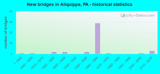
- New bridges - historical statistics
- 1Before 1900
- 11900-1909
- 21920-1929
- 21930-1939
- 21950-1959
- 291960-1969
- 11970-1979
- 12000-2009
- 32010-2019

- Reconstructed bridges - Historical Statistics
- 11950-1959
- 01960-1969
- 11970-1979
- 11980-1989
- 21990-1999
- 22000-2009
- 32010-2019


- Bridge Condition - Deck
- 10.0%Very good
- 15.0%Good
- 55.0%Satisfactory
- 20.0%Fair

- Bridge Condition - Superstructure
- 9.1%Very good
- 18.2%Good
- 31.8%Satisfactory
- 31.8%Fair
- 9.1%Poor

- Bridge Condition - Substructure
- 9.1%Very good
- 13.6%Good
- 40.9%Satisfactory
- 22.7%Fair
- 13.6%Poor

- Bridge Condition - Channel
- 22.2%Very good
- 11.1%Good
- 27.8%Satisfactory
- 33.3%Fair
- 5.6%Poor

- Bridge Condition - Culverts
- 50.0%Very good
- 50.0%Satisfactory
Find on map >> Show street view
Structure Number: 3477, Location: ALIQUIPPA OVER SR 3016 (Lat: 40.619031, Lng: -80.243631), Route carried "on" structure: State highway 51, Year Built: 1963, Status: Open, Structure Length: 2.71m (8.89ft), Average Daily Traffic: 8,304 (year 2022), Truck Traffic: 7%, Average Future Daily Traffic: 8,984 (year 2032), Design Load: HS 20, Features Intersected: SR 3016-FRANKLIN AVENUE, Facility Carried by Structure: CONSTITUTION BL
Minimum Vertical Clearance: 30+ m (98+ ft), Kilometerpoint: 5.625, Lanes on structure: 4, Lanes under structure: 2, Base Highway Network: Yes, Owner: State Highway Agency, Approaching Roadway Width: 16.5m (54.1ft), Skew: 23 degrees, Material/Design: Prestressed concrete, Design/Construction: Box Beam or Girders - Multiple, Number Of Spans In Main Unit: 1, Length of Maximum Span: 26.5m (86.9ft), Curb or Sidewalk Widths: Left: 0.9m (3.0ft), Right: 0.9m (3.0ft), Curb-To-Curb Width: 16.5m (54.1ft), Out-to-Out Width: 19.1m (62.7ft)
Condition: Deck: Good, Superstructure: Good, Substructure: Satisfactory, Operating Rating: 99.8 metric tons, Method Used To Determine Operating Rating: Load Factor (LF), Inventory Rating: 12.7 metric tons, Method Used To Determine Inventory Rating: Load Factor (LF), Structural Evaluation: High priority of corrective action, Deck Geometry: Meets minimum limits, Underclear: Equal to present minimum criteria, Approach Roadway Alignment: Equal to present desirable criteria, Length Of Structure Improvement: 2.30m (7.55ft), Designated Inspection Frequency: Every 24 months, Inspection Date: August 2021, Bridge Improvement Cost: $40,000, Roadway Improvement Cost: $117,000, Total Project Cost: $537,000, Deck Structure Type: Concrete Cast-file-Place, Wearing Surface/Protective System: Wearing Surface: Monolithic Concrete
Find on map >> Show street view
Structure Number: 3508, Location: OVER CLOSED SR 3024 (Lat: 40.578542, Lng: -80.289619), Route carried "on" structure: Interstate 376, Year Built: 1969, Year Reconstructed: 2008, Status: Open, Structure Length: 4.27m (14.01ft), Average Daily Traffic: 16,582 (year 2021), Truck Traffic: 16%, Average Future Daily Traffic: 11,261 (year 2032), Design Load: HS 20, Features Intersected: CLOSED SR 3024
Minimum Vertical Clearance: 30+ m (98+ ft), Kilometerpoint: 23.677, Lanes on structure: 2, Lanes under structure: 2, Base Highway Network: Yes, Owner: State Highway Agency, Approaching Roadway Width: 12.2m (40.0ft), Skew: 11 degrees, Material/Design: Steel continuous, Design/Construction: Stringer/Multi-beam, Number Of Spans In Main Unit: 3, Length of Maximum Span: 17.1m (56.1ft), Curb or Sidewalk Widths: Left: 0.2m (0.7ft), Right: 0.2m (0.7ft), Curb-To-Curb Width: 12.2m (40.0ft), Out-to-Out Width: 13.4m (44.0ft)
Condition: Deck: Satisfactory, Superstructure: Satisfactory, Substructure: Satisfactory, Operating Rating: 71.7 metric tons, Method Used To Determine Operating Rating: Load Factor (LF), Inventory Rating: 42.6 metric tons, Method Used To Determine Inventory Rating: Load Factor (LF), Structural Evaluation: Equal to present minimum criteria, Deck Geometry: Better than present minimum criteria, Underclear: Superior to present desirable criteria, Approach Roadway Alignment: Equal to present desirable criteria, Length Of Structure Improvement: 5.20m (17.06ft), Designated Inspection Frequency: Every 24 months, Inspection Date: April 2021, Bridge Improvement Cost: $40,000, Roadway Improvement Cost: $118,000, Total Project Cost: $540,000, Deck Structure Type: Concrete Cast-file-Place, Wearing Surface/Protective System: Wearing Surface: Latex Concrete, Deck Protection: Epoxy Coated Reinforcing
Find on map >> Show street view
Structure Number: 3509, Location: I376 WB O/GREEN GARDEN RD (Lat: 40.600842, Lng: -80.299033), Route carried "on" structure: Interstate 376, Year Built: 1969, Year Reconstructed: 2002, Status: Open, Structure Length: 5.09m (16.70ft), Average Daily Traffic: 16,688 (year 2021), Truck Traffic: 12%, Average Future Daily Traffic: 10,656 (year 2032), Design Load: HS 20, Features Intersected: SR 3016-GREEN GARDEN RD
Minimum Vertical Clearance: 30+ m (98+ ft), Kilometerpoint: 21.243, Lanes on structure: 2, Lanes under structure: 8, Base Highway Network: Yes, Owner: State Highway Agency, Approaching Roadway Width: 11.9m (39.0ft), Skew: 10 degrees, Material/Design: Prestressed concrete, Design/Construction: Box Beam or Girders - Multiple, Number Of Spans In Main Unit: 1, Number Of Approach Spans: 2, Length of Maximum Span: 22.6m (74.1ft), Curb or Sidewalk Widths: Left: 0.2m (0.7ft), Right: 0.2m (0.7ft), Curb-To-Curb Width: 11.7m (38.4ft), Out-to-Out Width: 13.0m (42.7ft)
Condition: Deck: Satisfactory, Superstructure: Satisfactory, Substructure: Fair, Operating Rating: 53.5 metric tons, Method Used To Determine Operating Rating: Load Factor (LF), Inventory Rating: 17.2 metric tons, Method Used To Determine Inventory Rating: Load Factor (LF), Structural Evaluation: Meets minimum limits, Deck Geometry: Equal to present minimum criteria, Underclear: Meets minimum limits, Approach Roadway Alignment: Equal to present desirable criteria, Length Of Structure Improvement: 5.10m (16.73ft), Designated Inspection Frequency: Every 24 months, Inspection Date: April 2021, Bridge Improvement Cost: $24,000, Roadway Improvement Cost: $72,000, Total Project Cost: $329,000, Deck Structure Type: Concrete Cast-file-Place, Wearing Surface/Protective System: Wearing Surface: Latex Concrete
Find on map >> Show street view
Structure Number: 3511, Location: INTER. OF GREENGARDENRD (Lat: 40.600914, Lng: -80.299411), Route carried "on" structure: Interstate 376, Year Built: 1969, Status: Open, Structure Length: 4.97m (16.31ft), Average Daily Traffic: 16,582 (year 2021), Truck Traffic: 16%, Average Future Daily Traffic: 11,261 (year 2032), Design Load: HS 20, Features Intersected: SR 3016-GREEN GARDEN RD, Facility Carried by Structure: BEAVER VALLEY EX
Minimum Vertical Clearance: 30+ m (98+ ft), Kilometerpoint: 21.309, Lanes on structure: 3, Lanes under structure: 8, Base Highway Network: Yes, Owner: State Highway Agency, Approaching Roadway Width: 15.8m (51.8ft), Skew: 10 degrees, Material/Design: Prestressed concrete, Design/Construction: Box Beam or Girders - Single/Spread, Number Of Spans In Main Unit: 3, Length of Maximum Span: 24.1m (79.1ft), Curb or Sidewalk Widths: Left: 0.2m (0.7ft), Right: 0.2m (0.7ft), Curb-To-Curb Width: 15.4m (50.5ft), Out-to-Out Width: 16.6m (54.5ft)
Condition: Deck: Fair, Superstructure: Fair, Substructure: Poor, Operating Rating: 64.4 metric tons, Method Used To Determine Operating Rating: Load Factor (LF), Inventory Rating: 23.6 metric tons, Method Used To Determine Inventory Rating: Load Factor (LF), Structural Evaluation: Meets minimum limits, Deck Geometry: Somewhat better than minimum adequacy, Underclear: Somewhat better than minimum adequacy, Approach Roadway Alignment: Equal to present desirable criteria, Length Of Structure Improvement: 5.00m (16.40ft), Designated Inspection Frequency: Every 24 months, Inspection Date: April 2021, Bridge Improvement Cost: $75,000, Roadway Improvement Cost: $222,000, Total Project Cost: $1,016,000, Deck Structure Type: Concrete Cast-file-Place, Wearing Surface/Protective System: Wearing Surface: Latex Concrete
Find on map >> Show street view
Structure Number: 3512, Location: 600' N OF ALIQ INTER (Lat: 40.603933, Lng: -80.302158), Route carried "on" structure: Interstate 376, Year Built: 1969, Year Reconstructed: 2015, Status: Open, Structure Length: 9.20m (30.18ft), Average Daily Traffic: 14,710 (year 2021), Truck Traffic: 14%, Average Future Daily Traffic: 15,050 (year 2032), Design Load: HS 20, Features Intersected: SR 3013,RACCOON CREEK, Facility Carried by Structure: BEAVER VALLEY EXPY
Minimum Vertical Clearance: 30+ m (98+ ft), Kilometerpoint: 20.392, Lanes on structure: 3, Lanes under structure: 2, Base Highway Network: Yes, Owner: State Highway Agency, Approaching Roadway Width: 14.6m (47.9ft), Skew: 11 degrees, Material/Design: Prestressed concrete, Design/Construction: Stringer/Multi-beam, Number Of Spans In Main Unit: 4, Length of Maximum Span: 25.6m (84.0ft), Curb or Sidewalk Widths: Left: 0.2m (0.7ft), Right: 0.2m (0.7ft), Curb-To-Curb Width: 12.2m (40.0ft), Out-to-Out Width: 13.4m (44.0ft)
Condition: Deck: Good, Superstructure: Satisfactory, Substructure: Satisfactory, Channel: Satisfactory, Operating Rating: 77.1 metric tons, Method Used To Determine Operating Rating: Load Factor (LF), Inventory Rating: 22.7 metric tons, Method Used To Determine Inventory Rating: Load Factor (LF), Structural Evaluation: Somewhat better than minimum adequacy, Deck Geometry: High priority of corrective action, Underclear: Meets minimum limits, Waterway Adequacy: Superior to present desirable criteria, Approach Roadway Alignment: Better than present minimum criteria, Length Of Structure Improvement: 9.20m (30.18ft), Designated Inspection Frequency: Every 24 months, Inspection Date: April 2021, Deck Structure Type: Concrete Cast-file-Place, Wearing Surface/Protective System: Wearing Surface: Monolithic Concrete, Deck Protection: Epoxy Coated Reinforcing
Find on map >> Show street view
Structure Number: 3514, Location: 1 MI N OF ALIQUIPPA INT (Lat: 40.609031, Lng: -80.314142), Route carried "on" structure: Interstate 376, Year Built: 1969, Year Reconstructed: 2015, Status: Open, Structure Length: 11.89m (39.01ft), Average Daily Traffic: 14,710 (year 2021), Truck Traffic: 14%, Average Future Daily Traffic: 15,050 (year 2032), Design Load: HS 20, Features Intersected: RELOCATED RACCOON CREEK
Minimum Vertical Clearance: 30+ m (98+ ft), Kilometerpoint: 19.603, Lanes on structure: 2, Base Highway Network: Yes, Owner: State Highway Agency, Approaching Roadway Width: 11.3m (37.1ft), Skew: 12 degrees, Material/Design: Steel continuous, Design/Construction: Girder and Floorbeam System, Number Of Spans In Main Unit: 3, Length of Maximum Span: 44.8m (147.0ft), Curb or Sidewalk Widths: Left: 0.2m (0.7ft), Right: 0.2m (0.7ft), Curb-To-Curb Width: 10.2m (33.5ft), Out-to-Out Width: 11.4m (37.4ft)
Condition: Deck: Satisfactory, Superstructure: Satisfactory, Substructure: Fair, Channel: Very good, Operating Rating: 50.8 metric tons, Method Used To Determine Operating Rating: Load Factor (LF), Inventory Rating: 30.8 metric tons, Method Used To Determine Inventory Rating: Load Factor (LF), Structural Evaluation: Somewhat better than minimum adequacy, Deck Geometry: Meets minimum limits, Waterway Adequacy: Superior to present desirable criteria, Approach Roadway Alignment: Equal to present desirable criteria, Length Of Structure Improvement: 11.90m (39.04ft), Designated Inspection Frequency: Every 24 months, Critical Feature Inspection Frequency: Every 24 months, Inspection Date: April 2020, Critical Feature Inspection Date: April 2020, Bridge Improvement Cost: $35,000, Roadway Improvement Cost: $102,000, Total Project Cost: $468,000, Deck Structure Type: Concrete Cast-file-Place, Wearing Surface/Protective System: Wearing Surface: Latex Concrete, Deck Protection: Epoxy Coated Reinforcing
Find on map >> Show street view
Structure Number: 3515, Location: 1.5 MI N OF SR 3016 (Lat: 40.611625, Lng: -80.318317), Route carried "on" structure: Interstate 376, Year Built: 1969, Status: Open, Structure Length: 4.18m (13.71ft), Average Daily Traffic: 14,710 (year 2021), Truck Traffic: 14%, Average Future Daily Traffic: 15,050 (year 2032), Design Load: HS 20, Features Intersected: BUNKER HILL ROAD, Facility Carried by Structure: BEAVER VALLEY EX
Minimum Vertical Clearance: 30+ m (98+ ft), Kilometerpoint: 18.813, Lanes on structure: 2, Lanes under structure: 2, Base Highway Network: Yes, Owner: State Highway Agency, Approaching Roadway Width: 12.2m (40.0ft), Skew: 12 degrees, Material/Design: Prestressed concrete, Design/Construction: Box Beam or Girders - Single/Spread, Number Of Spans In Main Unit: 3, Length of Maximum Span: 14.3m (46.9ft), Curb or Sidewalk Widths: Left: 0.2m (0.7ft), Right: 0.2m (0.7ft), Curb-To-Curb Width: 11.7m (38.4ft), Out-to-Out Width: 13.0m (42.7ft)
Condition: Deck: Satisfactory, Superstructure: Fair, Substructure: Fair, Operating Rating: 70.8 metric tons, Method Used To Determine Operating Rating: Load Factor (LF), Inventory Rating: 30.8 metric tons, Method Used To Determine Inventory Rating: Load Factor (LF), Structural Evaluation: Somewhat better than minimum adequacy, Deck Geometry: Equal to present minimum criteria, Underclear: Equal to present minimum criteria, Approach Roadway Alignment: Equal to present desirable criteria, Length Of Structure Improvement: 4.20m (13.78ft), Designated Inspection Frequency: Every 24 months, Inspection Date: April 2021, Bridge Improvement Cost: $40,000, Roadway Improvement Cost: $119,000, Total Project Cost: $545,000, Deck Structure Type: Concrete Cast-file-Place, Wearing Surface/Protective System: Wearing Surface: Latex Concrete
Find on map >> Show street view
Structure Number: 3689, Location: @ INTER W/ SR 3016 (Lat: 40.614942, Lng: -80.259978), Route carried "on" structure: State highway , Year Built: 1930, Status: Open, Structure Length: 0.79m (2.59ft), Average Daily Traffic: 4,357 (year 2022), Truck Traffic: 2%, Average Future Daily Traffic: 8,553 (year 2032), Design Load: HS 20, Features Intersected: LOGTOWN RUN, Facility Carried by Structure: SHEFFIELD AVE
Minimum Vertical Clearance: 30+ m (98+ ft), Kilometerpoint: 0.000, Lanes on structure: 2, Owner: State Highway Agency, Approaching Roadway Width: 10.4m (34.1ft), Material/Design: Concrete, Design/Construction: Culvert, Number Of Spans In Main Unit: 1, Length of Maximum Span: 7.9m (25.9ft), Curb or Sidewalk Widths: Left: 1.5m (4.9ft), Right: 0.0m
Condition: Channel: Fair, Culverts: Satisfactory, Operating Rating: 49.0 metric tons, Method Used To Determine Operating Rating: Field evaluation and documented engineering judgment, Inventory Rating: 32.7 metric tons, Method Used To Determine Inventory Rating: Field evaluation and documented engineering judgment, Structural Evaluation: Equal to present minimum criteria, Waterway Adequacy: Equal to present minimum criteria, Approach Roadway Alignment: Equal to present desirable criteria, Length Of Structure Improvement: 0.80m (2.62ft), Designated Inspection Frequency: Every 24 months, Inspection Date: April 2021
Find on map >> Show street view
Structure Number: 3704, Location: 300'E.OF INTER.W/TR60 (Lat: 40.601358, Lng: -80.297631), Route carried "on" structure: State highway , Year Built: 1969, Status: Open, Structure Length: 0.73m (2.40ft), Average Daily Traffic: 14,230 (year 2022), Truck Traffic: 4%, Average Future Daily Traffic: 17,639 (year 2032), Design Load: HS 20, Features Intersected: TRAMPMILL RUN, Facility Carried by Structure: GREEN GARDEN RD
Minimum Vertical Clearance: 30+ m (98+ ft), Kilometerpoint: 13.699, Lanes on structure: 6, Owner: State Highway Agency, Approaching Roadway Width: 22.9m (75.1ft), Skew: 22 degrees, Material/Design: Concrete, Design/Construction: Culvert, Number Of Spans In Main Unit: 1, Length of Maximum Span: 6.1m (20.0ft)
Condition: Channel: Satisfactory, Culverts: Satisfactory, Inventory Rating: 99.8 metric tons, Method Used To Determine Inventory Rating: Field evaluation and documented engineering judgment, Structural Evaluation: Equal to present minimum criteria, Waterway Adequacy: Superior to present desirable criteria, Approach Roadway Alignment: Equal to present desirable criteria, Length Of Structure Improvement: 0.60m (1.97ft), Designated Inspection Frequency: Every 24 months, Inspection Date: April 2021
Find on map >> Show street view
Structure Number: 3707, Location: 1000 FT SW OF SR 3001 (Lat: 40.612431, Lng: -80.261892), Route carried "on" structure: State highway , Year Built: 1962, Year Reconstructed: 1989, Status: Open, Structure Length: 0.79m (2.59ft), Average Daily Traffic: 10,039 (year 2022), Truck Traffic: 5%, Average Future Daily Traffic: 12,678 (year 2032), Design Load: HS 20, Features Intersected: LOGTOWN RUN, Facility Carried by Structure: KENNEDY BL
Minimum Vertical Clearance: 30+ m (98+ ft), Kilometerpoint: 17.246, Lanes on structure: 4, Owner: State Highway Agency, Approaching Roadway Width: 15.2m (49.9ft), Skew: 3 degrees, Material/Design: Concrete, Design/Construction: Slab, Number Of Spans In Main Unit: 1, Length of Maximum Span: 7.0m (23.0ft), Curb or Sidewalk Widths: Left: 1.5m (4.9ft), Right: 0.9m (3.0ft), Curb-To-Curb Width: 15.2m (49.9ft), Out-to-Out Width: 19.1m (62.7ft)
Condition: Deck: Good, Superstructure: Good, Substructure: Satisfactory, Channel: Fair, Operating Rating: 93.4 metric tons, Method Used To Determine Operating Rating: Load Factor (LF), Inventory Rating: 56.2 metric tons, Method Used To Determine Inventory Rating: Load Factor (LF), Structural Evaluation: Equal to present minimum criteria, Deck Geometry: High priority of corrective action, Waterway Adequacy: Equal to present minimum criteria, Approach Roadway Alignment: Equal to present desirable criteria, Length Of Structure Improvement: 0.80m (2.62ft), Designated Inspection Frequency: Every 24 months, Inspection Date: April 2021, Bridge Improvement Cost: $12,000, Roadway Improvement Cost: $34,000, Total Project Cost: $157,000, Deck Structure Type: Concrete Cast-file-Place, Wearing Surface/Protective System: Wearing Surface: Latex Concrete
Find on map >> Show street view
Structure Number: 3714, Location: INTERSECTION WITH SR 3020 (Lat: 40.578367, Lng: -80.340481), Route carried "on" structure: State highway , Year Built: 1900, Year Reconstructed: 1977, Status: Open, Structure Length: 1.37m (4.49ft), Average Daily Traffic: 206 (year 2022), Truck Traffic: 9%, Average Future Daily Traffic: 534 (year 2032), Design Load: HS 20, Features Intersected: SERVICE CREEK, Facility Carried by Structure: CLEARVIEW RD
Minimum Vertical Clearance: 30+ m (98+ ft), Kilometerpoint: 2.763, Lanes on structure: 2, Owner: State Highway Agency, Approaching Roadway Width: 5.5m (18.0ft), Material/Design: Steel, Design/Construction: Stringer/Multi-beam, Number Of Spans In Main Unit: 1, Length of Maximum Span: 12.2m (40.0ft), Curb-To-Curb Width: 6.2m (20.3ft), Out-to-Out Width: 6.9m (22.6ft)
Condition: Deck: Fair, Superstructure: Poor, Substructure: Satisfactory, Channel: Good, Operating Rating: 46.3 metric tons, Method Used To Determine Operating Rating: Load Factor (LF), Inventory Rating: 28.1 metric tons, Method Used To Determine Inventory Rating: Load Factor (LF), Structural Evaluation: Meets minimum limits, Deck Geometry: Meets minimum limits, Waterway Adequacy: Superior to present desirable criteria, Approach Roadway Alignment: Meets minimum limits, Length Of Structure Improvement: 1.30m (4.27ft), Designated Inspection Frequency: Every 24 months, Other Special Inspection Frequency: Every 6 months, Inspection Date: April 2021, Other Special Inspection Date: April 2021, Bridge Improvement Cost: $6,000, Roadway Improvement Cost: $23,000, Total Project Cost: $76,000, Deck Structure Type: Open Grating, Wearing Surface/Protective System: Wearing Surface: Other
Find on map >> Show street view
Structure Number: 3892, Location: 302002 WEST ALIQ (RAMP G) (Lat: 40.639533, Lng: -80.243758), Route carried "on" structure: Ramp State highway , Year Built: 1961, Year Reconstructed: 2015, Status: Open, Structure Length: 22.13m (72.60ft), Average Daily Traffic: 124 (year 2015), Truck Traffic: 40%, Average Future Daily Traffic: 135 (year 2035), Design Load: HS 20, Features Intersected: CSX,A&S,MAIN AV&MAPLE, Facility Carried by Structure: RAMP-G RD
Minimum Vertical Clearance: 30+ m (98+ ft), Kilometerpoint: 0.000, Lanes on structure: 2, Lanes under structure: 6, Owner: City or Municipal Highway Agency, Approaching Roadway Width: 8.5m (27.9ft), Material/Design: Steel continuous, Design/Construction: Stringer/Multi-beam, Number Of Spans In Main Unit: 3, Number Of Approach Spans: 5, Length of Maximum Span: 45.1m (148.0ft), Curb or Sidewalk Widths: Left: 0.2m (0.7ft), Right: 1.4m (4.6ft), Curb-To-Curb Width: 8.5m (27.9ft), Out-to-Out Width: 11.3m (37.1ft)
Condition: Deck: Satisfactory, Superstructure: Fair, Substructure: Good, Operating Rating: 66.2 metric tons, Method Used To Determine Operating Rating: Load Factor (LF), Inventory Rating: 39.9 metric tons, Method Used To Determine Inventory Rating: Load Factor (LF), Structural Evaluation: Somewhat better than minimum adequacy, Deck Geometry: High priority of corrective action, Underclear: High priority of corrective action, Approach Roadway Alignment: Equal to present desirable criteria, Length Of Structure Improvement: 23.60m (77.43ft), Designated Inspection Frequency: Every 24 months, Inspection Date: June 2021, Bridge Improvement Cost: $23,000, Roadway Improvement Cost: $68,000, Total Project Cost: $311,000, Deck Structure Type: Concrete Cast-file-Place, Wearing Surface/Protective System: Wearing Surface: Latex Concrete, Deck Protection: Epoxy Coated Reinforcing
Find on map >> Show street view
Structure Number: 4883, Location: 2 MI.E.OF JACKSONWALD (Lat: 40.322767, Lng: -75.817331), Route carried "on" structure: State highway 562, Year Built: 1926, Year Reconstructed: 1964, Status: Open, Structure Length: 0.82m (2.69ft), Average Daily Traffic: 3,910 (year 2021), Truck Traffic: 5%, Average Future Daily Traffic: 6,488 (year 2032), Design Load: HS 20, Features Intersected: OWATIN CREEK
Minimum Vertical Clearance: 30+ m (98+ ft), Kilometerpoint: 5.052, Lanes on structure: 2, Base Highway Network: Yes, Owner: State Highway Agency, Approaching Roadway Width: 7.3m (24.0ft), Skew: 3 degrees, Material/Design: Concrete, Design/Construction: Tee Beam, Number Of Spans In Main Unit: 1, Length of Maximum Span: 7.6m (24.9ft), Curb-To-Curb Width: 10.0m (32.8ft), Out-to-Out Width: 11.7m (38.4ft)
Condition: Deck: Satisfactory, Superstructure: Satisfactory, Substructure: Satisfactory, Channel: Satisfactory, Operating Rating: 49.0 metric tons, Method Used To Determine Operating Rating: Load Factor (LF), Inventory Rating: 29.0 metric tons, Method Used To Determine Inventory Rating: Load Factor (LF), Structural Evaluation: Equal to present minimum criteria, Deck Geometry: Meets minimum limits, Waterway Adequacy: Equal to present minimum criteria, Approach Roadway Alignment: Equal to present desirable criteria, Length Of Structure Improvement: 1.40m (4.59ft), Designated Inspection Frequency: Every 24 months, Inspection Date: June 2021, Bridge Improvement Cost: $11,000, Roadway Improvement Cost: $31,000, Total Project Cost: $144,000, Deck Structure Type: Concrete Cast-file-Place, Wearing Surface/Protective System: Wearing Surface: Integral Concrete
Find on map >> Show street view
Structure Number: 7307, Location: NEWTOWN & YARDLEY 32F12 (Lat: 40.235489, Lng: -74.896269), Route carried "on" structure: State highway , Year Built: 1966, Status: Open, Structure Length: 1.28m (4.20ft), Average Daily Traffic: 8,095 (year 2022), Truck Traffic: 6%, Average Future Daily Traffic: 11,837 (year 2032), Design Load: HS 20, Features Intersected: CORE CREEK, Facility Carried by Structure: LINDENHURST ROAD
Minimum Vertical Clearance: 30+ m (98+ ft), Kilometerpoint: 7.606, Lanes on structure: 2, Owner: State Highway Agency, Approaching Roadway Width: 7.3m (24.0ft), Skew: 4 degrees, Material/Design: Prestressed concrete, Design/Construction: Box Beam or Girders - Single/Spread, Number Of Spans In Main Unit: 1, Length of Maximum Span: 11.6m (38.1ft), Curb or Sidewalk Widths: Left: 0.5m (1.6ft), Right: 0.5m (1.6ft), Curb-To-Curb Width: 11.1m (36.4ft), Out-to-Out Width: 12.7m (41.7ft)
Condition: Deck: Satisfactory, Superstructure: Satisfactory, Substructure: Fair, Channel: Fair, Operating Rating: 55.3 metric tons, Method Used To Determine Operating Rating: Load Factor (LF), Inventory Rating: 30.8 metric tons, Method Used To Determine Inventory Rating: Load Factor (LF), Structural Evaluation: Somewhat better than minimum adequacy, Deck Geometry: Meets minimum limits, Waterway Adequacy: Better than present minimum criteria, Approach Roadway Alignment: Somewhat better than minimum adequacy, Length Of Structure Improvement: 1.90m (6.23ft), Designated Inspection Frequency: Every 24 months, Inspection Date: July 2021, Deck Structure Type: Concrete Cast-file-Place, Wearing Surface/Protective System: Wearing Surface: Bituminous
Find on map >> Show street view
Structure Number: 10916, Location: GREENVILLE PIKE NO.1 (Lat: 41.176708, Lng: -79.348478), Route carried "on" structure: State highway 66, Year Built: 1965, Year Reconstructed: 2001, Status: Open, Structure Length: 8.11m (26.61ft), Average Daily Traffic: 6,478 (year 2022), Truck Traffic: 10%, Average Future Daily Traffic: 7,526 (year 2032), Design Load: HS 20, Features Intersected: SR0080 EB & BRUSH RUN
Minimum Vertical Clearance: 30+ m (98+ ft), Kilometerpoint: 20.818, Lanes on structure: 4, Lanes under structure: 2, Base Highway Network: Yes, Owner: State Highway Agency, Approaching Roadway Width: 18.6m (61.0ft), Skew: 22 degrees, Material/Design: Prestressed concrete, Design/Construction: Box Beam or Girders - Single/Spread, Number Of Spans In Main Unit: 4, Length of Maximum Span: 22.9m (75.1ft), Curb or Sidewalk Widths: Left: 0.2m (0.7ft), Right: 0.2m (0.7ft), Curb-To-Curb Width: 18.7m (61.4ft), Out-to-Out Width: 19.9m (65.3ft)
Condition: Deck: Satisfactory, Superstructure: Fair, Substructure: Satisfactory, Channel: Satisfactory, Operating Rating: 59.0 metric tons, Method Used To Determine Operating Rating: Load Factor (LF), Inventory Rating: 28.1 metric tons, Method Used To Determine Inventory Rating: Load Factor (LF), Structural Evaluation: Somewhat better than minimum adequacy, Deck Geometry: Equal to present minimum criteria, Underclear: Somewhat better than minimum adequacy, Waterway Adequacy: Superior to present desirable criteria, Approach Roadway Alignment: Equal to present desirable criteria, Length Of Structure Improvement: 9.10m (29.86ft), Designated Inspection Frequency: Every 24 months, Inspection Date: May 2021, Bridge Improvement Cost: $85,000, Roadway Improvement Cost: $251,000, Total Project Cost: $1,151,000, Deck Structure Type: Concrete Cast-file-Place, Wearing Surface/Protective System: Wearing Surface: Epoxy Overlay, Membrane: Epoxy, Deck Protection: Epoxy Coated Reinforcing
Find on map >> Show street view
Structure Number: 12889, Location: WEST MEAD TOWNSHIP (Lat: 41.640000, Lng: -80.156667), Route carried "on" structure: State highway , Year Built: 1973, Status: Open, Structure Length: 8.78m (28.81ft), Average Daily Traffic: 212 (year 2022), Truck Traffic: 8%, Average Future Daily Traffic: 289 (year 2032), Design Load: HS 20, Features Intersected: OVER SR 6,FRENCH CK.PWY., Facility Carried by Structure: SR 2101,TERRACE ST
Minimum Vertical Clearance: 30+ m (98+ ft), Kilometerpoint: 0.000, Lanes on structure: 2, Lanes under structure: 8, Owner: State Highway Agency, Approaching Roadway Width: 7.6m (24.9ft), Skew: 5 degrees, Material/Design: Steel continuous, Design/Construction: Stringer/Multi-beam, Number Of Spans In Main Unit: 2, Length of Maximum Span: 43.3m (142.1ft), Curb or Sidewalk Widths: Left: 0.2m (0.7ft), Right: 1.5m (4.9ft), Curb-To-Curb Width: 11.0m (36.1ft), Out-to-Out Width: 13.6m (44.6ft)
Condition: Deck: Fair, Superstructure: Satisfactory, Substructure: Good, Operating Rating: 58.1 metric tons, Method Used To Determine Operating Rating: Load Factor (LF), Inventory Rating: 34.5 metric tons, Method Used To Determine Inventory Rating: Load Factor (LF), Structural Evaluation: Equal to present minimum criteria, Deck Geometry: Equal to present desirable criteria, Underclear: Equal to present minimum criteria, Approach Roadway Alignment: Better than present minimum criteria, Length Of Structure Improvement: 8.80m (28.87ft), Designated Inspection Frequency: Every 24 months, Inspection Date: August 2021, Bridge Improvement Cost: $32,000, Roadway Improvement Cost: $94,000, Total Project Cost: $431,000, Deck Structure Type: Concrete Cast-file-Place, Wearing Surface/Protective System: Wearing Surface: Monolithic Concrete
Find on map >> Show street view
Structure Number: 19714, Location: STUMP CREEK NO.3 (Lat: 41.034903, Lng: -78.820831), Route carried "on" structure: State highway , Year Built: 1938, Status: Open, Structure Length: 2.26m (7.41ft), Average Daily Traffic: 201 (year 2022), Truck Traffic: 1%, Average Future Daily Traffic: 268 (year 2032), Features Intersected: STUMP CREEK, Facility Carried by Structure: SR2012
Minimum Vertical Clearance: 30+ m (98+ ft), Kilometerpoint: 0.000, Lanes on structure: 2, Owner: State Highway Agency, Approaching Roadway Width: 5.5m (18.0ft), Material/Design: Steel, Design/Construction: Stringer/Multi-beam, Number Of Spans In Main Unit: 1, Length of Maximum Span: 21.9m (71.9ft), Curb or Sidewalk Widths: Left: 0.2m (0.7ft), Right: 0.2m (0.7ft), Curb-To-Curb Width: 6.7m (22.0ft), Out-to-Out Width: 7.3m (24.0ft)
Condition: Deck: Fair, Superstructure: Fair, Substructure: Fair, Channel: Poor, Operating Rating: 61.7 metric tons, Method Used To Determine Operating Rating: Load Factor (LF), Inventory Rating: 36.3 metric tons, Method Used To Determine Inventory Rating: Load Factor (LF), Structural Evaluation: Somewhat better than minimum adequacy, Deck Geometry: Meets minimum limits, Waterway Adequacy: Better than present minimum criteria, Approach Roadway Alignment: Equal to present desirable criteria, Length Of Structure Improvement: 3.00m (9.84ft), Designated Inspection Frequency: Every 24 months, Inspection Date: September 2020, Bridge Improvement Cost: $20,000, Roadway Improvement Cost: $58,000, Total Project Cost: $268,000, Deck Structure Type: Closed Grating, Wearing Surface/Protective System: Wearing Surface: Bituminous
Find on map >> Show street view
Structure Number: 21746, Location: 0.2 MI.E. OF T.R. 72 (Lat: 40.223217, Lng: -76.425467), Route carried "on" structure: State highway , Year Built: 1920, Status: Open, Structure Length: 0.82m (2.69ft), Average Daily Traffic: 894 (year 2020), Truck Traffic: 14%, Average Future Daily Traffic: 943 (year 2032), Design Load: H 15, Features Intersected: CHICKIES CREEK, Facility Carried by Structure: SR4032 Mountain Rd
Minimum Vertical Clearance: 30+ m (98+ ft), Kilometerpoint: 6.140, Lanes on structure: 2, Owner: State Highway Agency, Approaching Roadway Width: 6.7m (22.0ft), Material/Design: Steel, Design/Construction: Stringer/Multi-beam, Number Of Spans In Main Unit: 1, Length of Maximum Span: 7.3m (24.0ft), Curb-To-Curb Width: 5.4m (17.7ft), Out-to-Out Width: 6.2m (20.3ft)
Condition: Deck: Satisfactory, Superstructure: Fair, Substructure: Poor, Channel: Satisfactory, Operating Rating: 49.0 metric tons, Method Used To Determine Operating Rating: Load Factor (LF), Inventory Rating: 32.7 metric tons, Method Used To Determine Inventory Rating: Load Factor (LF), Structural Evaluation: Meets minimum limits, Deck Geometry: High priority of replacement, Waterway Adequacy: Better than present minimum criteria, Approach Roadway Alignment: Somewhat better than minimum adequacy, Length Of Structure Improvement: 1.40m (4.59ft), Designated Inspection Frequency: Every 24 months, Inspection Date: April 2021, Bridge Improvement Cost: $24,000, Roadway Improvement Cost: $71,000, Total Project Cost: $324,000, Deck Structure Type: Concrete Cast-file-Place, Wearing Surface/Protective System: Wearing Surface: Bituminous, Membrane: Preformed Fabric
Find on map >> Show street view
Structure Number: 23462, Location: MOSSERVILLE (Lat: 40.694417, Lng: -75.763569), Route carried "on" structure: City street , Year Built: 1834, Status: Posted for load, Structure Length: 0.85m (2.79ft), Average Daily Traffic: 100 (year 1980), Truck Traffic: 1%, Average Future Daily Traffic: 140 (year 2000), Design Load: HS 20+Mod, Features Intersected: ONTELAUNEE CREEK, Facility Carried by Structure: SPRINGHOUSE ROAD
Minimum Vertical Clearance: 30+ m (98+ ft), Kilometerpoint: 0.000, Lanes on structure: 2, Owner: County Highway Agency, Approaching Roadway Width: 4.9m (16.1ft), Skew: 2 degrees, Material/Design: Masonry, Design/Construction: Arch - Deck, Number Of Spans In Main Unit: 2, Length of Maximum Span: 4.3m (14.1ft), Curb-To-Curb Width: 5.2m (17.1ft), Out-to-Out Width: 6.4m (21.0ft)
Condition: Superstructure: Poor, Substructure: Poor, Channel: Fair, Operating Rating: 32.7 metric tons, Method Used To Determine Operating Rating: Field evaluation and documented engineering judgment, Inventory Rating: 21.8 metric tons, Method Used To Determine Inventory Rating: Field evaluation and documented engineering judgment, Structural Evaluation: Meets minimum limits, Deck Geometry: High priority of corrective action, Waterway Adequacy: Equal to present minimum criteria, Approach Roadway Alignment: Equal to present desirable criteria, Length Of Structure Improvement: 0.80m (2.62ft), Designated Inspection Frequency: Every 24 months, Other Special Inspection Frequency: Every 12 months, Inspection Date: April 2020, Other Special Inspection Date: May 2021, Bridge Improvement Cost: $1,000, Roadway Improvement Cost: $10,000, Total Project Cost: $13,000
Find on map >> Show street view
Structure Number: 23546, Location: NEAR EMMAUS BOROUGH (Lat: 40.531033, Lng: -75.520169), Route carried "on" structure: State highway , Year Built: 1955, Status: Open, Structure Length: 4.36m (14.30ft), Average Daily Traffic: 1,079 (year 2020), Truck Traffic: 3%, Average Future Daily Traffic: 1,867 (year 2030), Design Load: HS 20, Features Intersected: PA TPK (I-476), Facility Carried by Structure: SR 2018, LR39026
Minimum Vertical Clearance: 30+ m (98+ ft), Kilometerpoint: 7.873, Lanes on structure: 2, Lanes under structure: 4, Owner: State Toll Authority, Approaching Roadway Width: 5.8m (19.0ft), Skew: 2 degrees, Material/Design: Steel continuous, Design/Construction: Stringer/Multi-beam, Number Of Spans In Main Unit: 3, Length of Maximum Span: 24.7m (81.0ft), Curb or Sidewalk Widths: Left: 0.5m (1.6ft), Right: 0.5m (1.6ft), Curb-To-Curb Width: 9.1m (29.9ft), Out-to-Out Width: 10.7m (35.1ft)
Condition: Deck: Satisfactory, Superstructure: Fair, Substructure: Satisfactory, Operating Rating: 52.6 metric tons, Method Used To Determine Operating Rating: Load Factor (LF), Inventory Rating: 30.8 metric tons, Method Used To Determine Inventory Rating: Load Factor (LF), Structural Evaluation: Somewhat better than minimum adequacy, Deck Geometry: Somewhat better than minimum adequacy, Underclear: High priority of corrective action, Approach Roadway Alignment: Equal to present desirable criteria, Length Of Structure Improvement: 5.30m (17.39ft), Designated Inspection Frequency: Every 24 months, Critical Feature Inspection Frequency: Every 24 months, Inspection Date: August 2021, Critical Feature Inspection Date: August 2021, Bridge Improvement Cost: $13,000, Roadway Improvement Cost: $39,000, Total Project Cost: $179,000, Deck Structure Type: Concrete Cast-file-Place, Wearing Surface/Protective System: Wearing Surface: Bituminous
Find on map >> Show street view
Structure Number: 27375, Location: N. OF T-PIKE 31A5/3257H9 (Lat: 40.131422, Lng: -75.201867), Route carried "on" structure: State highway 309, Year Built: 1958, Year Reconstructed: 2007, Status: Open, Structure Length: 1.65m (5.41ft), Average Daily Traffic: 51,390 (year 2022), Truck Traffic: 4%, Average Future Daily Traffic: 67,664 (year 2032), Design Load: HL 93, Features Intersected: BRANCH OF SANDY RUN
Minimum Vertical Clearance: 30+ m (98+ ft), Kilometerpoint: 10.120, Lanes on structure: 4, Base Highway Network: Yes, Owner: State Highway Agency, Approaching Roadway Width: 21.3m (69.9ft), Skew: 31 degrees, Material/Design: Concrete, Design/Construction: Tee Beam, Number Of Spans In Main Unit: 2, Length of Maximum Span: 7.0m (23.0ft)
Condition: Superstructure: Good, Substructure: Satisfactory, Channel: Fair, Operating Rating: 76.2 metric tons, Method Used To Determine Operating Rating: Load Factor (LF), Inventory Rating: 33.6 metric tons, Method Used To Determine Inventory Rating: Load Factor (LF), Structural Evaluation: Equal to present minimum criteria, Waterway Adequacy: Equal to present minimum criteria, Approach Roadway Alignment: Equal to present desirable criteria, Length Of Structure Improvement: 2.30m (7.55ft), Designated Inspection Frequency: Every 24 months, Inspection Date: September 2020
Find on map >> Show street view
Structure Number: 3356, Location: 2.5 MI NE OF HARTLETON (Lat: 40.923281, Lng: -77.128331), Route carried "on" structure: State highway , Year Built: 1961, Status: Open, Structure Length: 1.25m (4.10ft), Average Daily Traffic: 307 (year 2020), Truck Traffic: 6%, Average Future Daily Traffic: 360 (year 2032), Design Load: H 20, Features Intersected: OVER BUFFALO CREEK, Facility Carried by Structure: SR 3005
Minimum Vertical Clearance: 30+ m (98+ ft), Kilometerpoint: 3.722, Lanes on structure: 2, Owner: State Highway Agency, Approaching Roadway Width: 8.5m (27.9ft), Material/Design: Concrete, Design/Construction: Tee Beam, Number Of Spans In Main Unit: 1, Length of Maximum Span: 12.2m (40.0ft), Curb or Sidewalk Widths: Left: 0.5m (1.6ft), Right: 0.5m (1.6ft), Curb-To-Curb Width: 10.4m (34.1ft), Out-to-Out Width: 12.1m (39.7ft)
Condition: Deck: Satisfactory, Superstructure: Good, Substructure: Good, Channel: Fair, Operating Rating: 54.4 metric tons, Method Used To Determine Operating Rating: Load Factor (LF), Inventory Rating: 32.7 metric tons, Method Used To Determine Inventory Rating: Load Factor (LF), Structural Evaluation: Better than present minimum criteria, Deck Geometry: Better than present minimum criteria, Waterway Adequacy: Superior to present desirable criteria, Approach Roadway Alignment: Somewhat better than minimum adequacy, Length Of Structure Improvement: 1.20m (3.94ft), Designated Inspection Frequency: Every 24 months, Inspection Date: May 2020, Bridge Improvement Cost: $8,000, Roadway Improvement Cost: $51,000, Total Project Cost: $107,000, Deck Structure Type: Concrete Cast-file-Place, Wearing Surface/Protective System: Wearing Surface: Monolithic Concrete
Find on map >> Show street view
Structure Number: 44029, Location: INT W/ TODD ROAD (Lat: 40.600000, Lng: -80.301667), Route carried "on" structure: State highway , Year Built: 2006, Status: Open, Structure Length: 4.02m (13.19ft), Average Daily Traffic: 8,198 (year 2022), Truck Traffic: 9%, Average Future Daily Traffic: 14,000 (year 2033), Design Load: HS 20, Features Intersected: RACCOON CREEK, Facility Carried by Structure: GREEN GARDEN ROAD
Minimum Vertical Clearance: 30+ m (98+ ft), Kilometerpoint: 13.448, Lanes on structure: 2, Owner: State Highway Agency, Approaching Roadway Width: 17.1m (56.1ft), Skew: 1 degrees, Material/Design: Steel, Design/Construction: Stringer/Multi-beam, Number Of Spans In Main Unit: 1, Length of Maximum Span: 38.4m (126.0ft), Curb or Sidewalk Widths: Left: 0.2m (0.7ft), Right: 0.2m (0.7ft), Curb-To-Curb Width: 17.3m (56.8ft), Out-to-Out Width: 18.4m (60.4ft)
Condition: Deck: Very good, Superstructure: Very good, Substructure: Very good, Channel: Very good, Operating Rating: 97.1 metric tons, Method Used To Determine Operating Rating: Load Factor (LF), Inventory Rating: 58.1 metric tons, Method Used To Determine Inventory Rating: Load Factor (LF), Structural Evaluation: Equal to present desirable criteria, Deck Geometry: Superior to present desirable criteria, Waterway Adequacy: Superior to present desirable criteria, Approach Roadway Alignment: Equal to present desirable criteria, Designated Inspection Frequency: Every 24 months, Inspection Date: April 2021, Deck Structure Type: Concrete Cast-file-Place, Wearing Surface/Protective System: Wearing Surface: Monolithic Concrete, Deck Protection: Epoxy Coated Reinforcing
Find on map >> Show street view
Structure Number: 46918, Location: SR 3013 INTERSECTION (Lat: 40.573333, Lng: -80.307222), Route carried "on" structure: State highway , Year Built: 2011, Status: Open, Structure Length: 4.42m (14.50ft), Average Daily Traffic: 304 (year 2022), Truck Traffic: 4%, Average Future Daily Traffic: 500 (year 2037), Design Load: HL 93, Features Intersected: RACCOON CREEK, Facility Carried by Structure: TANK FARM ROAD
Minimum Vertical Clearance: 30+ m (98+ ft), Kilometerpoint: 6.122, Lanes on structure: 2, Owner: State Highway Agency, Approaching Roadway Width: 10.1m (33.1ft), Material/Design: Prestressed concrete continuous, Design/Construction: Box Beam or Girders - Single/Spread, Number Of Spans In Main Unit: 2, Length of Maximum Span: 22.3m (73.2ft), Curb-To-Curb Width: 8.9m (29.2ft), Out-to-Out Width: 9.9m (32.5ft)
Condition: Deck: Very good, Superstructure: Very good, Substructure: Very good, Channel: Very good, Operating Rating: 62.2 metric tons, Method Used To Determine Operating Rating: Assigned ratings based on Load and Resistance Factor Design (LRFD) reported by rating factor (RF) using HL93 loadings, Inventory Rating: 39.2 metric tons, Method Used To Determine Inventory Rating: Assigned ratings based on Load and Resistance Factor Design (LRFD) reported by rating factor (RF) using HL93 loadings, Structural Evaluation: Equal to present desirable criteria, Deck Geometry: Equal to present minimum criteria, Waterway Adequacy: Equal to present desirable criteria, Approach Roadway Alignment: Meets minimum limits, Designated Inspection Frequency: Every 24 months, Inspection Date: April 2021, Deck Structure Type: Concrete Cast-file-Place, Wearing Surface/Protective System: Wearing Surface: Monolithic Concrete, Deck Protection: Epoxy Coated Reinforcing
Find on map >> Show street view
Structure Number: 52619, Location: 1350' EAST OF SR 3022 (Lat: 40.577625, Lng: -80.337422), Route carried "on" structure: State highway , Year Built: 2015, Status: Open, Structure Length: 1.46m (4.79ft), Average Daily Traffic: 275 (year 2022), Truck Traffic: 7%, Average Future Daily Traffic: 400 (year 2035), Design Load: HL 93, Features Intersected: SERVICE CREEK, Facility Carried by Structure: SERVICE CREEK ROAD
Minimum Vertical Clearance: 30+ m (98+ ft), Kilometerpoint: 0.000, Lanes on structure: 2, Owner: State Highway Agency, Approaching Roadway Width: 8.5m (27.9ft), Skew: 2 degrees, Material/Design: Concrete, Design/Construction: Culvert, Number Of Spans In Main Unit: 1, Length of Maximum Span: 14.6m (47.9ft)
Condition: Channel: Very good, Culverts: Very good, Operating Rating: 51.8 metric tons, Method Used To Determine Operating Rating: Assigned ratings based on Load and Resistance Factor Design (LRFD) reported by rating factor (RF) using HL93 loadings, Inventory Rating: 38.9 metric tons, Method Used To Determine Inventory Rating: Assigned ratings based on Load and Resistance Factor Design (LRFD) reported by rating factor (RF) using HL93 loadings, Structural Evaluation: Equal to present desirable criteria, Waterway Adequacy: Superior to present desirable criteria, Approach Roadway Alignment: Equal to present desirable criteria, Designated Inspection Frequency: Every 24 months, Inspection Date: April 2021
Find on map >> Show street view
Structure Number: 54057, Location: 0.5 MI.SOUTH OF SR 3007 (Lat: 40.595208, Lng: -80.280292), Route carried "on" structure: State highway , Year Built: 2017, Status: Open, Structure Length: 1.04m (3.41ft), Average Daily Traffic: 1,592 (year 2020), Truck Traffic: 2%, Average Future Daily Traffic: 1,613 (year 2037), Design Load: HL 93, Features Intersected: TRAMPMILL RUN CREEK, Facility Carried by Structure: KANE RD (SR 3009)
Minimum Vertical Clearance: 30+ m (98+ ft), Kilometerpoint: 4.212, Lanes on structure: 2, Owner: State Highway Agency, Maintenance Responsibility: Private, Approaching Roadway Width: 6.4m (21.0ft), Skew: 5 degrees, Material/Design: Concrete, Design/Construction: Culvert, Number Of Spans In Main Unit: 1, Length of Maximum Span: 9.4m (30.8ft), Curb-To-Curb Width: 8.7m (28.5ft), Out-to-Out Width: 12.6m (41.3ft)
Condition: Channel: Good, Culverts: Very good, Operating Rating: 51.5 metric tons, Method Used To Determine Operating Rating: Assigned ratings based on Load and Resistance Factor Design (LRFD) reported by rating factor (RF) using HL93 loadings, Inventory Rating: 36.0 metric tons, Method Used To Determine Inventory Rating: Assigned ratings based on Load and Resistance Factor Design (LRFD) reported by rating factor (RF) using HL93 loadings, Structural Evaluation: Equal to present desirable criteria, Deck Geometry: Somewhat better than minimum adequacy, Waterway Adequacy: Better than present minimum criteria, Approach Roadway Alignment: Equal to present desirable criteria, Designated Inspection Frequency: Every 24 months, Inspection Date: March 2021, Wearing Surface/Protective System: Wearing Surface: Bituminous, Membrane: Preformed Fabric, Deck Protection: Epoxy Coated Reinforcing
Find on map >> Show street view
Structure Number: 3477, Location: ALIQUIPPA OVER SR 3016 (Lat: 40.619031, Lng: -80.243631), Route carried "under" structure: State highway , Year Built: 1963, Structure Length: 0. m, Average Daily Traffic: 11,351 (year 2022), Truck Traffic: 3%, Features Intersected: SR 3016-FRANKLIN AVENUE, Facility Carried by Structure: CONSTITUTION BL
Minimum Vertical Clearance: 4.52m (14.83ft), Kilometerpoint: 18.577, Lanes on structure: 4, Lanes under structure: 2, Material/Design: Prestressed concrete, Design/Construction: Box Beam or Girders - Multiple, Length of Maximum Span: 26.5m (86.9ft)
Find on map >> Show street view
Structure Number: 3507, Location: 1.6 MI S OF GREENGARDEN R (Lat: 40.578533, Lng: -80.289339), Route carried "under" structure: State highway 3024, Year Built: 1969, Structure Length: 0. m, Average Daily Traffic: 1 (year 2011), Truck Traffic: 6%, Features Intersected: BRYSON ROAD, Facility Carried by Structure: BEAVER VALLEY EXPY
Minimum Vertical Clearance: 4.40m (14.44ft), Kilometerpoint: 0.000, Lanes on structure: 2, Lanes under structure: 2, Material/Design: Steel, Design/Construction: Stringer/Multi-beam, Length of Maximum Span: 31.1m (102.0ft)
Find on map >> Show street view
Structure Number: 3508, Location: OVER CLOSED SR 3024 (Lat: 40.578542, Lng: -80.289619), Route carried "under" structure: State highway 3024, Year Built: 1969, Structure Length: 0. m, Average Daily Traffic: 100 (year 1997), Truck Traffic: 6%, Features Intersected: CLOSED SR 3024, Facility Carried by Structure: SR 0376 EB
Minimum Vertical Clearance: 7.42m (24.34ft), Kilometerpoint: 0.000, Lanes on structure: 2, Lanes under structure: 2, Material/Design: Steel continuous, Design/Construction: Stringer/Multi-beam, Length of Maximum Span: 17.1m (56.1ft)
Find on map >> Show street view
Structure Number: 3509, Location: I376 WB O/GREEN GARDEN RD (Lat: 40.600842, Lng: -80.299033), Route carried "under" structure: State highway , Year Built: 1969, Structure Length: 0. m, Average Daily Traffic: 7,230 (year 2022), Truck Traffic: 5%, Features Intersected: SR 3016-GREEN GARDEN RD, Facility Carried by Structure: SR 0376 WB
Minimum Vertical Clearance: 4.42m (14.50ft), Kilometerpoint: 13.699, Lanes on structure: 2, Lanes under structure: 4, Material/Design: Prestressed concrete, Design/Construction: Box Beam or Girders - Multiple, Length of Maximum Span: 22.6m (74.1ft)
Find on map >> Show street view
Structure Number: 3509, Location: I376 WB O/GREEN GARDEN RD (Lat: 40.600842, Lng: -80.299033), Route carried "under" structure: State highway , Year Built: 1969, Structure Length: 0. m, Average Daily Traffic: 7,000 (year 2022), Truck Traffic: 4%, Features Intersected: SR 3016-GREEN GARDEN RD, Facility Carried by Structure: SR 0376 WB
Minimum Vertical Clearance: 4.42m (14.50ft), Kilometerpoint: 13.699, Lanes on structure: 2, Lanes under structure: 4, Material/Design: Prestressed concrete, Design/Construction: Box Beam or Girders - Multiple, Length of Maximum Span: 22.6m (74.1ft)
Find on map >> Show street view
Structure Number: 3511, Location: INTER. OF GREENGARDENRD (Lat: 40.600914, Lng: -80.299411), Route carried "under" structure: State highway , Year Built: 1969, Structure Length: 0. m, Average Daily Traffic: 7,000 (year 2022), Truck Traffic: 4%, Features Intersected: SR 3016-GREEN GARDEN RD, Facility Carried by Structure: BEAVER VALLEY EX
Minimum Vertical Clearance: 4.95m (16.24ft), Kilometerpoint: 13.699, Lanes on structure: 3, Lanes under structure: 4, Material/Design: Prestressed concrete, Design/Construction: Box Beam or Girders - Single/Spread, Length of Maximum Span: 24.1m (79.1ft)
Find on map >> Show street view
Structure Number: 3511, Location: INTER. OF GREENGARDENRD (Lat: 40.600914, Lng: -80.299411), Route carried "under" structure: State highway , Year Built: 1969, Structure Length: 0. m, Average Daily Traffic: 7,230 (year 2022), Truck Traffic: 5%, Features Intersected: SR 3016-GREEN GARDEN RD, Facility Carried by Structure: BEAVER VALLEY EX
Minimum Vertical Clearance: 4.95m (16.24ft), Kilometerpoint: 13.699, Lanes on structure: 3, Lanes under structure: 4, Material/Design: Prestressed concrete, Design/Construction: Box Beam or Girders - Single/Spread, Length of Maximum Span: 24.1m (79.1ft)
Find on map >> Show street view
Structure Number: 3512, Location: 600' N OF ALIQ INTER (Lat: 40.603933, Lng: -80.302158), Route carried "under" structure: State highway , Year Built: 1969, Structure Length: 0. m, Average Daily Traffic: 919 (year 2021), Truck Traffic: 25%, Features Intersected: SR 3013,RACCOON CREEK, Facility Carried by Structure: BEAVER VALLEY EXPY
Minimum Vertical Clearance: 5.49m (18.01ft), Kilometerpoint: 7.424, Lanes on structure: 3, Lanes under structure: 2, Material/Design: Prestressed concrete, Design/Construction: Stringer/Multi-beam, Length of Maximum Span: 25.6m (84.0ft)
Find on map >> Show street view
Structure Number: 3513, Location: 600'N.OF ALIQ.INTERCH. (Lat: 40.604042, Lng: -80.302706), Route carried "under" structure: State highway , Year Built: 1969, Structure Length: 0. m, Average Daily Traffic: 919 (year 2021), Truck Traffic: 25%, Features Intersected: SR 3013,RACCOON CREEK, Facility Carried by Structure: BEAVER VALLEY EX
Minimum Vertical Clearance: 5.23m (17.16ft), Kilometerpoint: 7.424, Lanes on structure: 2, Lanes under structure: 2, Material/Design: Prestressed concrete, Design/Construction: Stringer/Multi-beam, Length of Maximum Span: 25.9m (85.0ft)
Find on map >> Show street view
Structure Number: 3515, Location: 1.5 MI N OF SR 3016 (Lat: 40.611625, Lng: -80.318317), Route carried "under" structure: City street , Year Built: 1969, Structure Length: 0. m, Average Daily Traffic: 250 (year 1991), Truck Traffic: 1%, Features Intersected: BUNKER HILL ROAD, Facility Carried by Structure: BEAVER VALLEY EX
Minimum Vertical Clearance: 4.62m (15.16ft), Kilometerpoint: 0.000, Lanes on structure: 2, Lanes under structure: 2, Material/Design: Prestressed concrete, Design/Construction: Box Beam or Girders - Single/Spread, Length of Maximum Span: 14.3m (46.9ft)
Find on map >> Show street view
Structure Number: 3517, Location: 1.5 MI N OF SR 3016 (Lat: 40.611892, Lng: -80.318881), Route carried "under" structure: City street , Year Built: 1969, Structure Length: 0. m, Average Daily Traffic: 250 (year 1991), Truck Traffic: 1%, Features Intersected: BUNKER HILL ROAD, Facility Carried by Structure: BEAVER VALLEY EXPY
Minimum Vertical Clearance: 6.12m (20.08ft), Kilometerpoint: 0.000, Lanes on structure: 2, Lanes under structure: 2, Material/Design: Prestressed concrete, Design/Construction: Box Beam or Girders - Single/Spread, Length of Maximum Span: 15.2m (49.9ft)
Find on map >> Show street view
Structure Number: 3518, Location: TWP.RD.625 OVER TR 60 (Lat: 40.600789, Lng: -80.316631), Route carried "under" structure: Interstate 376, Year Built: 1969, Structure Length: 0. m, Average Daily Traffic: 15,678 (year 2021), Truck Traffic: 13%, Features Intersected: BEAVER VALLEY EX., Facility Carried by Structure: MAIN STREET
Minimum Vertical Clearance: 4.50m (14.76ft), Kilometerpoint: 15.630, Lanes on structure: 2, Lanes under structure: 4, Material/Design: Prestressed concrete, Design/Construction: Box Beam or Girders - Single/Spread, Length of Maximum Span: 18.3m (60.0ft)
Find on map >> Show street view
Structure Number: 3518, Location: TWP.RD.625 OVER TR 60 (Lat: 40.600789, Lng: -80.316631), Route carried "under" structure: Interstate 376, Year Built: 1969, Structure Length: 0. m, Average Daily Traffic: 15,454 (year 2021), Truck Traffic: 14%, Features Intersected: BEAVER VALLEY EX., Facility Carried by Structure: MAIN STREET
Minimum Vertical Clearance: 4.50m (14.76ft), Kilometerpoint: 15.593, Lanes on structure: 2, Lanes under structure: 4, Material/Design: Prestressed concrete, Design/Construction: Box Beam or Girders - Single/Spread, Length of Maximum Span: 18.3m (60.0ft)
Find on map >> Show street view
Structure Number: 373, Location: RAMP G OVER APPL 294 (Lat: 40.592222, Lng: -80.240725), Route carried "under" structure: State highway 51, Year Built: 1965, Structure Length: 0. m, Average Daily Traffic: 5,424 (year 2020), Truck Traffic: 10%, Features Intersected: SR 51 NB, Facility Carried by Structure: RAMP G RD
Minimum Vertical Clearance: 5.43m (17.81ft), Kilometerpoint: 7.429, Lanes on structure: 2, Lanes under structure: 2, Material/Design: Steel, Design/Construction: Stringer/Multi-beam, Length of Maximum Span: 16.5m (54.1ft)
Find on map >> Show street view
Structure Number: 3892, Location: 302002 WEST ALIQ (RAMP G) (Lat: 40.639533, Lng: -80.243758), Route carried "under" structure: City street , Year Built: 1961, Structure Length: 0. m, Average Daily Traffic: 50 (year 2019), Features Intersected: CSX,A&S,MAIN AV&MAPLE, Facility Carried by Structure: RAMP-G RD
Minimum Vertical Clearance: 4.27m (14.01ft), Kilometerpoint: 0.000, Lanes on structure: 2, Lanes under structure: 2, Material/Design: Steel continuous, Design/Construction: Stringer/Multi-beam, Length of Maximum Span: 45.1m (148.0ft)
Find on map >> Show street view
Structure Number: 3892, Location: 302002 WEST ALIQ (RAMP G) (Lat: 40.639533, Lng: -80.243758), Route carried "under" structure: City street , Year Built: 1961, Structure Length: 0. m, Average Daily Traffic: 50 (year 2019), Features Intersected: CSX,A&S,MAIN AV&MAPLE, Facility Carried by Structure: RAMP-G RD
Minimum Vertical Clearance: 7.29m (23.92ft), Kilometerpoint: 0.000, Lanes on structure: 2, Lanes under structure: 2, Material/Design: Steel continuous, Design/Construction: Stringer/Multi-beam, Length of Maximum Span: 45.1m (148.0ft)