Bridge Statistics for Albany, California (CA)
Condition, Traffic, Stress, Structural Evaluation, Project Costs
- National Bridge Inventory (NBI) Statistics
- 12Number of bridges
- 266ft / 81.4mTotal length
- 730,162Total average daily traffic
- 33,107Total average daily truck traffic
- National Bridge Inventory (NBI) Registered Bridges for Albany
- No street view available for this location
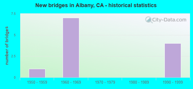
- New bridges - historical statistics
- 11950-1959
- 71960-1969
- 41990-1999


- Bridge Condition - Superstructure
- 66.7%Good
- 33.3%Fair
Find on map >> Show street view
Structure Number: 33 0051R, Location: 04-ALA-080-R7.20-ALB (Lat: 37.886017, Lng: -122.308786), Route carried "on" structure: Interstate 80, Year Built: 1999, Status: Open, Structure Length: 64.31m (210.99ft), Average Daily Traffic: 111,600 (year 2009), Truck Traffic: 9%, Average Future Daily Traffic: 445,815 (year 2043), Design Load: HS 20+Mod, Features Intersected: UP RR,BNSF,AMTRAK,I 580
Minimum Vertical Clearance: 30+ m (98+ ft), Kilometerpoint: 7.200, Lanes on structure: 4, Lanes under structure: 8, Base Highway Network: Yes (, Subroute: 1), Owner: State Highway Agency, Approaching Roadway Width: 20.7m (67.9ft), Skew: 3 degrees, Material/Design: Prestressed concrete continuous, Design/Construction: Box Beam or Girders - Multiple, Number Of Spans In Main Unit: 17, Length of Maximum Span: 49.6m (162.7ft), Curb-To-Curb Width: 20.7m (67.9ft), Out-to-Out Width: 21.8m (71.5ft)
Condition: Deck: Fair, Superstructure: Good, Substructure: Good, Operating Rating: 54.1 metric tons, Method Used To Determine Operating Rating: Assigned rating based on Load Factor Design (LFD) reported in metric tons, Inventory Rating: 32.4 metric tons, Method Used To Determine Inventory Rating: Assigned rating based on Load Factor Design (LFD) reported in metric tons, Structural Evaluation: Better than present minimum criteria, Deck Geometry: Equal to present minimum criteria, Underclear: Somewhat better than minimum adequacy, Approach Roadway Alignment: Equal to present desirable criteria, Designated Inspection Frequency: Every 24 months, Inspection Date: March 2021, Deck Structure Type: Concrete Cast-file-Place
Find on map >> Show street view
Structure Number: 33 0156, Location: 04-ALA-580-48.04-ALB (Lat: 37.897131, Lng: -122.311361), Route carried "on" structure: Interstate 580, Year Built: 1991, Status: Open, Structure Length: 1.95m (6.40ft), Average Daily Traffic: 99,000 (year 2017), Truck Traffic: 15%, Average Future Daily Traffic: 230,917 (year 2038), Design Load: HS 20+Mod, Features Intersected: CERRITO CREEK
Minimum Vertical Clearance: 30+ m (98+ ft), Kilometerpoint: 48.040, Lanes on structure: 6, Base Highway Network: Yes, Owner: State Highway Agency, Approaching Roadway Width: 32.9m (107.9ft), Skew: 30 degrees, Material/Design: Concrete continuous, Design/Construction: Slab, Number Of Spans In Main Unit: 2, Length of Maximum Span: 9.4m (30.8ft), Curb-To-Curb Width: 38.0m (124.7ft), Out-to-Out Width: 44.6m (146.3ft)
Condition: Deck: Fair, Superstructure: Fair, Substructure: Good, Channel: Very good, Operating Rating: 54.1 metric tons, Method Used To Determine Operating Rating: Assigned rating based on Load Factor Design (LFD) reported in metric tons, Inventory Rating: 32.4 metric tons, Method Used To Determine Inventory Rating: Assigned rating based on Load Factor Design (LFD) reported in metric tons, Structural Evaluation: Somewhat better than minimum adequacy, Deck Geometry: Superior to present desirable criteria, Waterway Adequacy: Equal to present desirable criteria, Approach Roadway Alignment: Equal to present desirable criteria, Designated Inspection Frequency: Every 24 months, Inspection Date: August 2020, Deck Structure Type: Concrete Cast-file-Place
Find on map >> Show street view
Structure Number: 33C0184, Location: NEAR I-80 (Lat: 37.887044, Lng: -122.307753), Route carried "on" structure: City street , Year Built: 1963, Year Reconstructed: 2000, Status: Open, Structure Length: 13.81m (45.31ft), Average Daily Traffic: 10,629 (year 1977), Truck Traffic: 5%, Average Future Daily Traffic: 27,169 (year 2040), Design Load: HS 20, Features Intersected: UP RR, BNSF RY, & AMTRAK, Facility Carried by Structure: BUCHANAN ST
Minimum Vertical Clearance: 30+ m (98+ ft), Kilometerpoint: 0.000, Lanes on structure: 4, Lanes under structure: 2, Base Highway Network: Yes, Owner: City or Municipal Highway Agency, Approaching Roadway Width: 17.0m (55.8ft), Skew: 10 degrees, Material/Design: Concrete continuous, Design/Construction: Stringer/Multi-beam, Number Of Spans In Main Unit: 9, Length of Maximum Span: 20.7m (67.9ft), Curb or Sidewalk Widths: Left: 3.7m (12.1ft), Right: 0.9m (3.0ft), Curb-To-Curb Width: 17.0m (55.8ft), Out-to-Out Width: 23.4m (76.8ft)
Condition: Deck: Fair, Superstructure: Good, Substructure: Good, Operating Rating: 45.3 metric tons, Method Used To Determine Operating Rating: Allowable Stress (AS), Inventory Rating: 32.6 metric tons, Method Used To Determine Inventory Rating: Allowable Stress (AS), Structural Evaluation: Better than present minimum criteria, Deck Geometry: Somewhat better than minimum adequacy, Underclear: High priority of corrective action, Approach Roadway Alignment: Equal to present minimum criteria, Designated Inspection Frequency: Every 24 months, Inspection Date: November 2020, Deck Structure Type: Concrete Cast-file-Place
Find on map >> Show street view
Structure Number: 33C025, Location: 100 FT N BURKHART AVE (Lat: 37.685497, Lng: -122.153408), Route carried "on" structure: City street , Year Built: 1955, Status: Open, Structure Length: 1.31m (4.30ft), Average Daily Traffic: 1,000 (year 2016), Average Future Daily Traffic: 814 (year 2040), Features Intersected: ESTUDILLO CANAL, Facility Carried by Structure: INVERNESS ST
Minimum Vertical Clearance: 30+ m (98+ ft), Kilometerpoint: 0.000, Lanes on structure: 2, Owner: City or Municipal Highway Agency, Approaching Roadway Width: 9.8m (32.2ft), Material/Design: Concrete continuous, Design/Construction: Culvert, Number Of Spans In Main Unit: 4, Length of Maximum Span: 3.0m (9.8ft), Curb or Sidewalk Widths: Left: 2.4m (7.9ft), Right: 2.4m (7.9ft), Curb-To-Curb Width: 9.7m (31.8ft), Out-to-Out Width: 15.3m (50.2ft)
Condition: Channel: Very good, Culverts: Satisfactory, Operating Rating: 40.5 metric tons, Method Used To Determine Operating Rating: Field evaluation and documented engineering judgment, Inventory Rating: 24.3 metric tons, Method Used To Determine Inventory Rating: Field evaluation and documented engineering judgment, Structural Evaluation: Equal to present minimum criteria, Deck Geometry: Equal to present minimum criteria, Waterway Adequacy: Meets minimum limits, Approach Roadway Alignment: Equal to present desirable criteria, Designated Inspection Frequency: Every 24 months, Inspection Date: October 2020, Deck Structure Type: Concrete Cast-file-Place, Wearing Surface/Protective System: Wearing Surface: Bituminous
Find on map >> Show street view
Structure Number: 33 0051L, Location: 04-ALA-080-R7.20-ALB (Lat: 37.886003, Lng: -122.309033), Route carried "under" structure: Interstate 580, Year Built: 1960, Structure Length: 0. m, Average Daily Traffic: 220,000 (year 2009), Truck Traffic: 2%, Features Intersected: UP,BNSF,AMTRAK,E80-W580, Facility Carried by Structure: INTERSTATE 80 WB
Minimum Vertical Clearance: 4.67m (15.32ft), Kilometerpoint: 47.340, Lanes on structure: 4, Lanes under structure: 11, Material/Design: Steel, Design/Construction: Stringer/Multi-beam, Length of Maximum Span: 38.3m (125.7ft)
Find on map >> Show street view
Structure Number: 33 0051L, Location: 04-ALA-080-R7.20-ALB (Lat: 37.886003, Lng: -122.309033), Route carried "under" structure: City street , Year Built: 1960, Structure Length: 0. m, Average Daily Traffic: 3,000 (year 2009), Truck Traffic: 1%, Features Intersected: UP,BNSF,AMTRAK,E80-W580, Facility Carried by Structure: INTERSTATE 80 WB
Minimum Vertical Clearance: 6.24m (20.47ft), Kilometerpoint: 0.000, Lanes on structure: 4, Lanes under structure: 2, Material/Design: Steel, Design/Construction: Stringer/Multi-beam, Length of Maximum Span: 38.3m (125.7ft)
Find on map >> Show street view
Structure Number: 33 0051L, Location: 04-ALA-080-R7.20-ALB (Lat: 37.886003, Lng: -122.309033), Route carried "under" structure: City street , Year Built: 1960, Structure Length: 0. m, Average Daily Traffic: 7,000 (year 2009), Truck Traffic: 1%, Features Intersected: UP,BNSF,AMTRAK,E80-W580, Facility Carried by Structure: INTERSTATE 80 WB
Minimum Vertical Clearance: 5.05m (16.57ft), Kilometerpoint: 0.000, Lanes on structure: 4, Lanes under structure: 6, Material/Design: Steel, Design/Construction: Stringer/Multi-beam, Length of Maximum Span: 38.3m (125.7ft)
Find on map >> Show street view
Structure Number: 33 0051R, Location: 04-ALA-080-R7.20-ALB (Lat: 37.886017, Lng: -122.308786), Route carried "under" structure: Ramp Interstate 580, Year Built: 1999, Structure Length: 0. m, Average Daily Traffic: 220,000 (year 2009), Truck Traffic: 1%, Features Intersected: UP RR,BNSF,AMTRAK,I 580, Facility Carried by Structure: INTERSTATE 80 EB
Minimum Vertical Clearance: 5.79m (19.00ft), Kilometerpoint: 47.300, Lanes on structure: 4, Lanes under structure: 2, Material/Design: Prestressed concrete continuous, Design/Construction: Box Beam or Girders - Multiple, Length of Maximum Span: 49.6m (162.7ft)
Find on map >> Show street view
Structure Number: 33 0051R, Location: 04-ALA-080-R7.20-ALB (Lat: 37.886017, Lng: -122.308786), Route carried "under" structure: Ramp Interstate 580, Year Built: 1999, Structure Length: 0. m, Average Daily Traffic: 7,000 (year 2009), Truck Traffic: 1%, Features Intersected: UP RR,BNSF,AMTRAK,I 580, Facility Carried by Structure: INTERSTATE 80 EB
Minimum Vertical Clearance: 5.69m (18.67ft), Kilometerpoint: 47.530, Lanes on structure: 4, Lanes under structure: 1, Material/Design: Prestressed concrete continuous, Design/Construction: Box Beam or Girders - Multiple, Length of Maximum Span: 49.6m (162.7ft)
Find on map >> Show street view
Structure Number: 33C0184, Location: NEAR I-80 (Lat: 37.887044, Lng: -122.307753), Route carried "under" structure: City street , Year Built: 1963, Structure Length: 0. m, Average Daily Traffic: 10,629 (year 1998), Truck Traffic: 1%, Features Intersected: UP RR, BNSF RY, & AMTRAK, Facility Carried by Structure: BUCHANAN ST
Minimum Vertical Clearance: 4.52m (14.83ft), Kilometerpoint: 0.000, Lanes on structure: 4, Lanes under structure: 2, Material/Design: Concrete continuous, Design/Construction: Stringer/Multi-beam, Length of Maximum Span: 20.7m (67.9ft)
Find on map >> Show street view
Structure Number: 33C0258, Location: 0.3 MI E/O SAN PABLO AVE (Lat: 37.890467, Lng: -122.293325), Route carried "under" structure: City street , Year Built: 1968, Structure Length: 0. m, Average Daily Traffic: 19,700 (year 1997), Truck Traffic: 2%, Features Intersected: SOLANO AVE, Facility Carried by Structure: BARTD (R3002)
Minimum Vertical Clearance: 4.80m (15.75ft), Kilometerpoint: 0.000, Lanes under structure: 3, Material/Design: Prestressed concrete, Design/Construction: Box Beam or Girders - Multiple, Length of Maximum Span: 27.1m (88.9ft)
Find on map >> Show street view
Structure Number: 33C0259, Location: 0.3 MI E/O SAN PABLO AVE (Lat: 37.887706, Lng: -122.292433), Route carried "under" structure: City street , Year Built: 1968, Structure Length: 0. m, Average Daily Traffic: 20,604 (year 1999), Truck Traffic: 2%, Features Intersected: MARIN AVE, Facility Carried by Structure: BARTD (R3002)
Minimum Vertical Clearance: 5.51m (18.08ft), Kilometerpoint: 0.000, Lanes under structure: 4, Material/Design: Prestressed concrete, Design/Construction: Box Beam or Girders - Multiple, Length of Maximum Span: 31.4m (103.0ft)