Bridge Statistics for Acworth, Georgia (GA)
Condition, Traffic, Stress, Structural Evaluation, Project Costs
- National Bridge Inventory (NBI) Statistics
- 39Number of bridges
- 755ft / 230mTotal length
- $299,094,000Total costs
- 1,173,034Total average daily traffic
- 15,761Total average daily truck traffic
- National Bridge Inventory (NBI) Registered Bridges for Acworth
- No street view available for this location
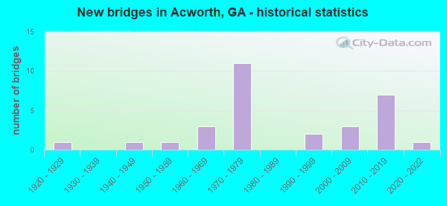
- New bridges - historical statistics
- 11920-1929
- 11940-1949
- 11950-1959
- 31960-1969
- 111970-1979
- 21990-1999
- 32000-2009
- 72010-2019
- 12020-2022

- Reconstructed bridges - Historical Statistics
- 11990-1999
- 22000-2009


- Bridge Condition - Deck
- 9.5%Very good
- 85.7%Good
- 4.8%Satisfactory

- Bridge Condition - Superstructure
- 33.3%Very good
- 61.9%Good
- 4.8%Satisfactory

- Bridge Condition - Substructure
- 23.8%Very good
- 57.1%Good
- 14.3%Satisfactory
- 4.8%Fair

- Bridge Condition - Channel
- 8.0%Excellent
- 48.0%Very good
- 28.0%Good
- 12.0%Satisfactory
- 4.0%Fair

- Bridge Condition - Culverts
- 11.1%Very good
- 77.8%Good
- 11.1%Satisfactory
Find on map >> Show street view
Structure Number: 150073, Location: 4.3 MI SE OF EMERSON (Lat: 34.088289, Lng: -84.697308), Route carried "on" structure: County highway 375, Year Built: 1977, Status: Open, Structure Length: 11.58m (37.99ft), Average Daily Traffic: 1,200 (year 2011), Truck Traffic: 1%, Average Future Daily Traffic: 1,800 (year 2031), Design Load: HS 20+Mod, Features Intersected: I-75, Facility Carried by Structure: GROOVERS ROAD
Minimum Vertical Clearance: 30+ m (98+ ft), Kilometerpoint: 1.609, Lanes on structure: 2, Lanes under structure: 6, Base Highway Network: Yes, Owner: State Highway Agency, Approaching Roadway Width: 14.0m (45.9ft), Skew: 3 degrees, Material/Design: Steel continuous, Design/Construction: Stringer/Multi-beam, Number Of Spans In Main Unit: 4, Length of Maximum Span: 38.1m (125.0ft), Curb-To-Curb Width: 14.6m (47.9ft), Out-to-Out Width: 15.4m (50.5ft)
Condition: Deck: Good, Superstructure: Good, Substructure: Good, Operating Rating: 59.8 metric tons, Method Used To Determine Operating Rating: Load Factor (LF), Inventory Rating: 35.3 metric tons, Method Used To Determine Inventory Rating: Load Factor (LF), Structural Evaluation: Better than present minimum criteria, Deck Geometry: Superior to present desirable criteria, Underclear: Better than present minimum criteria, Approach Roadway Alignment: Equal to present desirable criteria, Designated Inspection Frequency: Every 24 months, Inspection Date: October 2020, Bridge Improvement Cost: $1,485,000, Roadway Improvement Cost: $148,000, Total Project Cost: $2,227,000, Deck Structure Type: Concrete Cast-file-Place
Find on map >> Show street view
Structure Number: 150074, Location: 5.5 MI SE OF EMERSON (Lat: 34.080958, Lng: -84.676458), Route carried "on" structure: Interstate 75, Year Built: 1977, Status: Open, Structure Length: 5.61m (18.41ft), Average Daily Traffic: 99,550 (year 2011), Truck Traffic: 1%, Average Future Daily Traffic: 149,325 (year 2031), Design Load: HS 20+Mod, Features Intersected: M-9464 GLADE ROAD
Minimum Vertical Clearance: 30+ m (98+ ft), Kilometerpoint: 449.007, Lanes on structure: 3, Lanes under structure: 4, Base Highway Network: Yes, Owner: State Highway Agency, Approaching Roadway Width: 18.3m (60.0ft), Skew: 11 degrees, Material/Design: Steel, Design/Construction: Stringer/Multi-beam, Number Of Spans In Main Unit: 4, Length of Maximum Span: 16.5m (54.1ft), Curb-To-Curb Width: 18.3m (60.0ft), Out-to-Out Width: 19.0m (62.3ft)
Condition: Deck: Good, Superstructure: Good, Substructure: Good, Operating Rating: 48.9 metric tons, Method Used To Determine Operating Rating: Load Factor (LF), Inventory Rating: 29.0 metric tons, Method Used To Determine Inventory Rating: Load Factor (LF), Structural Evaluation: Better than present minimum criteria, Deck Geometry: Better than present minimum criteria, Underclear: Meets minimum limits, Approach Roadway Alignment: Equal to present desirable criteria, Designated Inspection Frequency: Every 24 months, Inspection Date: August 2020, Bridge Improvement Cost: $915,000, Roadway Improvement Cost: $91,000, Total Project Cost: $1,372,000, Deck Structure Type: Concrete Cast-file-Place, Wearing Surface/Protective System: Wearing Surface: Epoxy Overlay
Find on map >> Show street view
Structure Number: 150076, Location: 4.8 MI SE OF EMERSON (Lat: 34.085819, Lng: -84.688878), Route carried "on" structure: Interstate 75, Year Built: 1977, Status: Open, Structure Length: 0.82m (2.69ft), Average Daily Traffic: 83,640 (year 2011), Truck Traffic: 1%, Average Future Daily Traffic: 125,460 (year 2031), Design Load: HS 20+Mod, Features Intersected: TANYARD CREEK
Minimum Vertical Clearance: 30+ m (98+ ft), Kilometerpoint: 449.007, Lanes on structure: 6, Base Highway Network: Yes, Owner: State Highway Agency, Approaching Roadway Width: 31.7m (104.0ft), Skew: 14 degrees, Material/Design: Concrete, Design/Construction: Culvert, Number Of Spans In Main Unit: 2, Length of Maximum Span: 4.0m (13.1ft)
Condition: Channel: Very good, Culverts: Satisfactory, Structural Evaluation: Equal to present minimum criteria, Waterway Adequacy: Superior to present desirable criteria, Approach Roadway Alignment: Equal to present desirable criteria, Designated Inspection Frequency: Every 24 months, Underwater Inspection Frequency: Every 60 months, Inspection Date: October 2020, Underwater Inspection Date: May 2019, Bridge Improvement Cost: $221,000, Roadway Improvement Cost: $22,000, Total Project Cost: $331,000
Find on map >> Show street view
Structure Number: 570015, Location: 7.8 MI W OF WOODSTOCK (Lat: 34.079275, Lng: -84.653728), Route carried "on" structure: State highway 92, Year Built: 1976, Year Reconstructed: 2008, Status: Open, Structure Length: 9.88m (32.41ft), Average Daily Traffic: 18,950 (year 2011), Truck Traffic: 1%, Average Future Daily Traffic: 28,425 (year 2031), Design Load: HS 20+Mod, Features Intersected: I-75
Minimum Vertical Clearance: 30+ m (98+ ft), Kilometerpoint: 0.000, Lanes on structure: 8, Lanes under structure: 6, Base Highway Network: Yes, Owner: State Highway Agency, Approaching Roadway Width: 17.1m (56.1ft), Skew: 21 degrees, Material/Design: Steel continuous, Design/Construction: Stringer/Multi-beam, Number Of Spans In Main Unit: 4, Length of Maximum Span: 32.0m (105.0ft), Curb or Sidewalk Widths: Left: 1.9m (6.2ft), Right: 1.9m (6.2ft), Curb-To-Curb Width: 31.1m (102.0ft), Out-to-Out Width: 36.8m (120.7ft)
Condition: Deck: Good, Superstructure: Good, Substructure: Satisfactory, Operating Rating: 39.9 metric tons, Method Used To Determine Operating Rating: Load Factor (LF), Inventory Rating: 23.5 metric tons, Method Used To Determine Inventory Rating: Load Factor (LF), Structural Evaluation: Somewhat better than minimum adequacy, Deck Geometry: Somewhat better than minimum adequacy, Underclear: Better than present minimum criteria, Approach Roadway Alignment: Equal to present desirable criteria, Designated Inspection Frequency: Every 24 months, Inspection Date: May 2020, Bridge Improvement Cost: $3,337,000, Roadway Improvement Cost: $334,000, Total Project Cost: $5,006,000, Deck Structure Type: Concrete Cast-file-Place, Wearing Surface/Protective System: Deck Protection: Epoxy Coated Reinforcing
Find on map >> Show street view
Structure Number: 570037, Location: 6.5 MI W OF WOODSTOCK (Lat: 34.081378, Lng: -84.628228), Route carried "on" structure: Interstate 75, Year Built: 1976, Status: Open, Structure Length: 0.76m (2.49ft), Average Daily Traffic: 105,710 (year 2011), Truck Traffic: 1%, Average Future Daily Traffic: 158,565 (year 2031), Design Load: HS 20+Mod, Features Intersected: CLARK CREEK
Minimum Vertical Clearance: 30+ m (98+ ft), Kilometerpoint: 444.179, Lanes on structure: 3, Base Highway Network: Yes, Owner: State Highway Agency, Approaching Roadway Width: 18.3m (60.0ft), Skew: 3 degrees, Material/Design: Concrete, Design/Construction: Culvert, Number Of Spans In Main Unit: 2, Length of Maximum Span: 3.7m (12.1ft)
Condition: Channel: Good, Culverts: Good, Structural Evaluation: Better than present minimum criteria, Waterway Adequacy: Superior to present desirable criteria, Approach Roadway Alignment: Equal to present desirable criteria, Designated Inspection Frequency: Every 24 months, Inspection Date: May 2020, Bridge Improvement Cost: $124,000, Roadway Improvement Cost: $12,000, Total Project Cost: $186,000
Find on map >> Show street view
Structure Number: 570062, Location: 7.2 MI W OF WOODSTOCK (Lat: 34.079719, Lng: -84.641658), Route carried "on" structure: County highway 433, Year Built: 1976, Status: Open, Structure Length: 12.71m (41.70ft), Average Daily Traffic: 2,202 (year 2011), Truck Traffic: 1%, Average Future Daily Traffic: 3,303 (year 2031), Design Load: HS 20, Features Intersected: I-75, Facility Carried by Structure: PRIEST ROAD
Minimum Vertical Clearance: 30+ m (98+ ft), Kilometerpoint: 0.000, Lanes on structure: 2, Lanes under structure: 6, Base Highway Network: Yes, Owner: State Highway Agency, Approaching Roadway Width: 7.3m (24.0ft), Skew: 4 degrees, Material/Design: Steel continuous, Design/Construction: Stringer/Multi-beam, Number Of Spans In Main Unit: 4, Length of Maximum Span: 39.9m (130.9ft), Curb-To-Curb Width: 13.4m (44.0ft), Out-to-Out Width: 14.1m (46.3ft)
Condition: Deck: Good, Superstructure: Good, Substructure: Good, Operating Rating: 36.2 metric tons, Method Used To Determine Operating Rating: Load Factor (LF), Inventory Rating: 21.7 metric tons, Method Used To Determine Inventory Rating: Load Factor (LF), Structural Evaluation: Somewhat better than minimum adequacy, Deck Geometry: Better than present minimum criteria, Underclear: Equal to present minimum criteria, Approach Roadway Alignment: Equal to present desirable criteria, Designated Inspection Frequency: Every 24 months, Inspection Date: May 2020, Bridge Improvement Cost: $1,629,000, Roadway Improvement Cost: $163,000, Total Project Cost: $2,444,000, Deck Structure Type: Concrete Cast-file-Place, Wearing Surface/Protective System: Deck Protection: Epoxy Coated Reinforcing
Find on map >> Show street view
Structure Number: 57007, Location: 6.3 MI W OF WOODSTOCK (Lat: 34.079458, Lng: -84.626208), Route carried "on" structure: County highway 1375, Year Built: 1976, Status: Open, Structure Length: 19.05m (62.50ft), Average Daily Traffic: 5,790 (year 2011), Truck Traffic: 1%, Average Future Daily Traffic: 8,685 (year 2031), Design Load: HS 20+Mod, Features Intersected: I-75 - CLARK CREEK, Facility Carried by Structure: WOODSTOCK ROAD
Minimum Vertical Clearance: 30+ m (98+ ft), Kilometerpoint: 0.000, Lanes on structure: 2, Lanes under structure: 6, Base Highway Network: Yes, Owner: State Highway Agency, Approaching Roadway Width: 7.3m (24.0ft), Skew: 1 degrees, Material/Design: Steel continuous, Design/Construction: Stringer/Multi-beam, Number Of Spans In Main Unit: 5, Number Of Approach Spans: 2, Length of Maximum Span: 36.9m (121.1ft), Curb-To-Curb Width: 13.5m (44.3ft), Out-to-Out Width: 14.2m (46.6ft)
Condition: Deck: Good, Superstructure: Good, Substructure: Good, Channel: Very good, Operating Rating: 54.4 metric tons, Method Used To Determine Operating Rating: Load Factor (LF), Inventory Rating: 31.7 metric tons, Method Used To Determine Inventory Rating: Load Factor (LF), Structural Evaluation: Better than present minimum criteria, Deck Geometry: Superior to present desirable criteria, Underclear: Equal to present minimum criteria, Waterway Adequacy: Superior to present desirable criteria, Approach Roadway Alignment: Equal to present desirable criteria, Designated Inspection Frequency: Every 24 months, Inspection Date: May 2020, Bridge Improvement Cost: $2,442,000, Roadway Improvement Cost: $244,000, Total Project Cost: $3,663,000, Deck Structure Type: Concrete Cast-file-Place, Wearing Surface/Protective System: Deck Protection: Epoxy Coated Reinforcing
Find on map >> Show street view
Structure Number: 575084, Location: 6.8 MI W OF WOODSTOCK (Lat: 34.085578, Lng: -84.636828), Route carried "on" structure: County highway 433, Year Built: 2002, Status: Open, Structure Length: 2.23m (7.32ft), Average Daily Traffic: 2,202 (year 2011), Truck Traffic: 1%, Average Future Daily Traffic: 3,303 (year 2031), Design Load: HS 20+Mod, Features Intersected: CLARK CREEK, Facility Carried by Structure: PRIEST ROAD
Minimum Vertical Clearance: 30+ m (98+ ft), Kilometerpoint: 1.609, Lanes on structure: 2, Base Highway Network: Yes, Owner: County Highway Agency, Approaching Roadway Width: 6.1m (20.0ft), Skew: 1 degrees, Material/Design: Prestressed concrete, Design/Construction: Stringer/Multi-beam, Number Of Spans In Main Unit: 1, Length of Maximum Span: 22.3m (73.2ft), Curb-To-Curb Width: 9.7m (31.8ft), Out-to-Out Width: 10.7m (35.1ft)
Condition: Deck: Good, Superstructure: Very good, Substructure: Good, Channel: Very good, Operating Rating: 83.4 metric tons, Method Used To Determine Operating Rating: Load Factor (LF), Inventory Rating: 33.5 metric tons, Method Used To Determine Inventory Rating: Load Factor (LF), Structural Evaluation: Better than present minimum criteria, Deck Geometry: Meets minimum limits, Waterway Adequacy: Superior to present desirable criteria, Approach Roadway Alignment: Equal to present minimum criteria, Designated Inspection Frequency: Every 24 months, Inspection Date: March 2020, Bridge Improvement Cost: $285,000, Roadway Improvement Cost: $29,000, Total Project Cost: $428,000, Deck Structure Type: Concrete Cast-file-Place
Find on map >> Show street view
Structure Number: 575093, Location: 7.8 MI. WEST OF WOODSTOCK (Lat: 34.090022, Lng: -84.652819), Route carried "on" structure: State highway 92, Year Built: 2008, Status: Open, Structure Length: 34.87m (114.40ft), Average Daily Traffic: 23,500 (year 2008), Truck Traffic: 4%, Average Future Daily Traffic: 3,533 (year 2031), Design Load: HS 20, Features Intersected: CLARK CREEK
Minimum Vertical Clearance: 30+ m (98+ ft), Kilometerpoint: 1.609, Lanes on structure: 2, Owner: State Highway Agency, Approaching Roadway Width: 8.5m (27.9ft), Skew: 10 degrees, Material/Design: Prestressed concrete, Design/Construction: Stringer/Multi-beam, Number Of Spans In Main Unit: 11, Length of Maximum Span: 31.7m (104.0ft), Curb or Sidewalk Widths: Left: 0.0m, Right: 1.8m (5.9ft), Curb-To-Curb Width: 9.6m (31.5ft), Out-to-Out Width: 12.3m (40.4ft)
Condition: Deck: Good, Superstructure: Very good, Substructure: Good, Channel: Satisfactory, Operating Rating: 72.5 metric tons, Method Used To Determine Operating Rating: Load Factor (LF), Inventory Rating: 31.7 metric tons, Method Used To Determine Inventory Rating: Load Factor (LF), Structural Evaluation: Better than present minimum criteria, Deck Geometry: Meets minimum limits, Waterway Adequacy: Superior to present desirable criteria, Approach Roadway Alignment: Equal to present desirable criteria, Designated Inspection Frequency: Every 24 months, Inspection Date: May 2020, Bridge Improvement Cost: $4,470,000, Roadway Improvement Cost: $447,000, Total Project Cost: $6,705,000, Deck Structure Type: Concrete Cast-file-Place
Find on map >> Show street view
Structure Number: 575094, Location: 7.8 MI. WEST OF WOODSTOCK (Lat: 34.090083, Lng: -84.653031), Route carried "on" structure: State highway 92, Year Built: 2008, Status: Open, Structure Length: 34.87m (114.40ft), Average Daily Traffic: 23,500 (year 2008), Truck Traffic: 4%, Average Future Daily Traffic: 3,533 (year 2031), Design Load: HS 20+Mod, Features Intersected: CLARK CREEK
Minimum Vertical Clearance: 30+ m (98+ ft), Kilometerpoint: 1.609, Lanes on structure: 2, Owner: State Highway Agency, Approaching Roadway Width: 8.5m (27.9ft), Skew: 10 degrees, Material/Design: Prestressed concrete, Design/Construction: Stringer/Multi-beam, Number Of Spans In Main Unit: 11, Length of Maximum Span: 31.7m (104.0ft), Curb or Sidewalk Widths: Left: 0.0m, Right: 1.8m (5.9ft), Curb-To-Curb Width: 9.6m (31.5ft), Out-to-Out Width: 12.3m (40.4ft)
Condition: Deck: Good, Superstructure: Good, Substructure: Good, Channel: Satisfactory, Operating Rating: 72.5 metric tons, Method Used To Determine Operating Rating: Load Factor (LF), Inventory Rating: 32.6 metric tons, Method Used To Determine Inventory Rating: Load Factor (LF), Structural Evaluation: Better than present minimum criteria, Deck Geometry: Meets minimum limits, Waterway Adequacy: Superior to present desirable criteria, Approach Roadway Alignment: Equal to present desirable criteria, Designated Inspection Frequency: Every 24 months, Inspection Date: May 2020, Bridge Improvement Cost: $4,470,000, Roadway Improvement Cost: $447,000, Total Project Cost: $6,705,000, Deck Structure Type: Concrete Cast-file-Place
Find on map >> Show street view
Structure Number: 575105, Location: 5 MI W OF WOODSTOCK (Lat: 34.113439, Lng: -84.611900), Route carried "on" structure: County highway 800, Year Built: 2017, Status: Open, Structure Length: 0.82m (2.69ft), Average Daily Traffic: 430 (year 2011), Truck Traffic: 8%, Average Future Daily Traffic: 645 (year 2031), Design Load: H 15, Features Intersected: KELLOGG CREEK, Facility Carried by Structure: CHELSEA LANE
Minimum Vertical Clearance: 30+ m (98+ ft), Kilometerpoint: 0.000, Lanes on structure: 2, Base Highway Network: Yes, Owner: County Highway Agency, Approaching Roadway Width: 7.3m (24.0ft), Material/Design: Steel, Design/Construction: Culvert, Number Of Spans In Main Unit: 3, Length of Maximum Span: 1.8m (5.9ft), Curb-To-Curb Width: 7.3m (24.0ft), Out-to-Out Width: 7.3m (24.0ft)
Condition: Channel: Very good, Culverts: Very good, Operating Rating: 29.9 metric tons, Method Used To Determine Operating Rating: Field evaluation and documented engineering judgment, Inventory Rating: 24.4 metric tons, Method Used To Determine Inventory Rating: Field evaluation and documented engineering judgment, Structural Evaluation: Equal to present minimum criteria, Deck Geometry: Meets minimum limits, Waterway Adequacy: Equal to present desirable criteria, Approach Roadway Alignment: Equal to present desirable criteria, Length Of Structure Improvement: 2.77m (9.09ft), Designated Inspection Frequency: Every 24 months, Inspection Date: March 2020, Bridge Improvement Cost: $6,734,000, Roadway Improvement Cost: $673,000, Total Project Cost: $10,101,000 ( Estimate for 2018)
Find on map >> Show street view
Structure Number: 670009, Location: 2.3 MI SOUTH OF ACWORTH (Lat: 34.033008, Lng: -84.668358), Route carried "on" structure: US 41, Year Built: 1949, Status: Open, Structure Length: 1.31m (4.30ft), Average Daily Traffic: 30,210 (year 2012), Truck Traffic: 1%, Average Future Daily Traffic: 45,315 (year 2032), Design Load: H 15, Features Intersected: BUTLER CREEK
Minimum Vertical Clearance: 30+ m (98+ ft), Kilometerpoint: 28.968, Lanes on structure: 4, Base Highway Network: Yes, Owner: State Highway Agency, Approaching Roadway Width: 18.3m (60.0ft), Skew: 10 degrees, Material/Design: Concrete, Design/Construction: Culvert, Number Of Spans In Main Unit: 4, Length of Maximum Span: 3.0m (9.8ft)
Condition: Channel: Satisfactory, Culverts: Good, Structural Evaluation: Better than present minimum criteria, Waterway Adequacy: Superior to present desirable criteria, Approach Roadway Alignment: Equal to present desirable criteria, Designated Inspection Frequency: Every 24 months, Inspection Date: May 2021, Bridge Improvement Cost: $260,000, Roadway Improvement Cost: $26,000, Total Project Cost: $389,000
Find on map >> Show street view
Structure Number: 67001, Location: 2 MI W OF ACWORTH (Lat: 34.055756, Lng: -84.709425), Route carried "on" structure: US 41, Year Built: 1950, Status: Open, Structure Length: 8.05m (26.41ft), Average Daily Traffic: 35,740 (year 2012), Truck Traffic: 1%, Average Future Daily Traffic: 53,610 (year 2032), Design Load: HS 20, Features Intersected: ALLATOONA CREEK (LAKE)
Minimum Vertical Clearance: 30+ m (98+ ft), Kilometerpoint: 33.796, Lanes on structure: 4, Base Highway Network: Yes, Owner: State Highway Agency, Approaching Roadway Width: 18.3m (60.0ft), Skew: 30 degrees, Material/Design: Steel continuous, Design/Construction: Stringer/Multi-beam, Number Of Spans In Main Unit: 3, Length of Maximum Span: 30.5m (100.1ft), Curb or Sidewalk Widths: Left: 0.7m (2.3ft), Right: 0.7m (2.3ft), Curb-To-Curb Width: 17.0m (55.8ft), Out-to-Out Width: 19.5m (64.0ft)
Condition: Deck: Good, Superstructure: Good, Substructure: Satisfactory, Channel: Fair, Operating Rating: 45.3 metric tons, Method Used To Determine Operating Rating: Load Factor (LF), Inventory Rating: 27.2 metric tons, Method Used To Determine Inventory Rating: Load Factor (LF), Structural Evaluation: Equal to present minimum criteria, Deck Geometry: Somewhat better than minimum adequacy, Waterway Adequacy: Superior to present desirable criteria, Approach Roadway Alignment: Equal to present desirable criteria, Length Of Structure Improvement: 14.51m (47.60ft), Designated Inspection Frequency: Every 24 months, Underwater Inspection Frequency: Every 60 months, Inspection Date: September 2021, Underwater Inspection Date: October 2018, Bridge Improvement Cost: $1,594,000, Roadway Improvement Cost: $159,000, Total Project Cost: $2,391,000, Deck Structure Type: Concrete Cast-file-Place
Find on map >> Show street view
Structure Number: 670036, Location: IN NORTH ACWORTH (Lat: 34.068728, Lng: -84.685858), Route carried "on" structure: State highway 92, Year Built: 1974, Status: Posted for load, Structure Length: 7.28m (23.88ft), Average Daily Traffic: 22,820 (year 2012), Truck Traffic: 4%, Average Future Daily Traffic: 34,230 (year 2032), Design Load: HS 20+Mod, Features Intersected: M-9028 -CSX RR - CS 108
Minimum Vertical Clearance: 30+ m (98+ ft), Kilometerpoint: 8.047, Lanes on structure: 4, Lanes under structure: 5, Base Highway Network: Yes, Owner: State Highway Agency, Approaching Roadway Width: 14.6m (47.9ft), Material/Design: Steel, Design/Construction: Stringer/Multi-beam, Number Of Spans In Main Unit: 4, Length of Maximum Span: 25.3m (83.0ft), Curb or Sidewalk Widths: Left: 1.6m (5.2ft), Right: 1.6m (5.2ft), Curb-To-Curb Width: 14.7m (48.2ft), Out-to-Out Width: 18.5m (60.7ft)
Condition: Deck: Good, Superstructure: Good, Substructure: Good, Operating Rating: 28.1 metric tons, Method Used To Determine Operating Rating: Load Factor (LF), Inventory Rating: 16.3 metric tons, Method Used To Determine Inventory Rating: Load Factor (LF), Structural Evaluation: Meets minimum limits, Deck Geometry: High priority of replacement, Underclear: Meets minimum limits, Approach Roadway Alignment: Equal to present desirable criteria, Bridge Posting: Required (Relationship of Operating Rating to Maximum Legal Load: 0.1 - 9.9% below), Designated Inspection Frequency: Every 24 months, Inspection Date: March 2021, Deck Structure Type: Concrete Cast-file-Place, Wearing Surface/Protective System: Wearing Surface: Bituminous
Find on map >> Show street view
Structure Number: 670037, Location: IN NORTH ACWORTH (Lat: 34.073000, Lng: -84.682058), Route carried "on" structure: State highway 92, Year Built: 1974, Status: Open, Structure Length: 0.64m (2.10ft), Average Daily Traffic: 22,820 (year 2012), Truck Traffic: 4%, Average Future Daily Traffic: 34,230 (year 2032), Design Load: HS 20+Mod, Features Intersected: TANYARD CREEK
Minimum Vertical Clearance: 30+ m (98+ ft), Kilometerpoint: 8.047, Lanes on structure: 2, Base Highway Network: Yes, Owner: State Highway Agency, Approaching Roadway Width: 7.3m (24.0ft), Skew: 1 degrees, Material/Design: Concrete, Design/Construction: Culvert, Number Of Spans In Main Unit: 2, Length of Maximum Span: 3.0m (9.8ft)
Condition: Channel: Good, Culverts: Good, Operating Rating: 55.3 metric tons, Method Used To Determine Operating Rating: Field evaluation and documented engineering judgment, Inventory Rating: 32.6 metric tons, Method Used To Determine Inventory Rating: Field evaluation and documented engineering judgment, Structural Evaluation: Better than present minimum criteria, Waterway Adequacy: Superior to present desirable criteria, Approach Roadway Alignment: Equal to present desirable criteria, Designated Inspection Frequency: Every 24 months, Inspection Date: March 2021
Find on map >> Show street view
Structure Number: 67005, Location: 3.7 MI S OF ACWORTH (Lat: 34.016369, Lng: -84.699108), Route carried "on" structure: County highway 4514, Year Built: 1967, Status: Open, Structure Length: 3.29m (10.79ft), Average Daily Traffic: 13,260 (year 2012), Truck Traffic: 1%, Average Future Daily Traffic: 19,890 (year 2032), Design Load: HS 20+Mod, Features Intersected: ALLATOONA CREEK, Facility Carried by Structure: MARS HILL ROAD
Minimum Vertical Clearance: 30+ m (98+ ft), Kilometerpoint: 20.921, Lanes on structure: 2, Base Highway Network: Yes, Owner: County Highway Agency, Approaching Roadway Width: 8.5m (27.9ft), Material/Design: Concrete, Design/Construction: Tee Beam, Number Of Spans In Main Unit: 3, Length of Maximum Span: 11.0m (36.1ft), Curb or Sidewalk Widths: Left: 0.7m (2.3ft), Right: 0.7m (2.3ft), Curb-To-Curb Width: 8.5m (27.9ft), Out-to-Out Width: 10.5m (34.4ft)
Condition: Deck: Good, Superstructure: Good, Substructure: Satisfactory, Channel: Good, Operating Rating: 46.2 metric tons, Method Used To Determine Operating Rating: Allowable Stress (AS), Inventory Rating: 32.6 metric tons, Method Used To Determine Inventory Rating: Allowable Stress (AS), Structural Evaluation: Equal to present minimum criteria, Deck Geometry: High priority of replacement, Waterway Adequacy: Superior to present desirable criteria, Approach Roadway Alignment: Equal to present desirable criteria, Designated Inspection Frequency: Every 24 months, Inspection Date: March 2021, Deck Structure Type: Concrete Cast-file-Place
Find on map >> Show street view
Structure Number: 67006, Location: IN SE ACWORTH (Lat: 34.052158, Lng: -84.663289), Route carried "on" structure: City street 9028, Year Built: 1927, Year Reconstructed: 2002, Status: Open, Structure Length: 3.17m (10.40ft), Average Daily Traffic: 12,870 (year 2012), Truck Traffic: 1%, Average Future Daily Traffic: 19,305 (year 2032), Design Load: H 15, Features Intersected: PROCTOR CREEK, Facility Carried by Structure: SOUTH MAIN STREET
Minimum Vertical Clearance: 30+ m (98+ ft), Kilometerpoint: 12.875, Lanes on structure: 2, Base Highway Network: Yes, Owner: City or Municipal Highway Agency, Approaching Roadway Width: 9.4m (30.8ft), Material/Design: Concrete, Design/Construction: Tee Beam, Number Of Spans In Main Unit: 4, Length of Maximum Span: 7.9m (25.9ft), Curb or Sidewalk Widths: Left: 1.8m (5.9ft), Right: 1.8m (5.9ft), Curb-To-Curb Width: 9.4m (30.8ft), Out-to-Out Width: 13.6m (44.6ft)
Condition: Deck: Good, Superstructure: Satisfactory, Substructure: Good, Channel: Good, Operating Rating: 48.0 metric tons, Method Used To Determine Operating Rating: Load Factor (LF), Inventory Rating: 29.0 metric tons, Method Used To Determine Inventory Rating: Load Factor (LF), Structural Evaluation: Equal to present minimum criteria, Deck Geometry: High priority of corrective action, Waterway Adequacy: Equal to present desirable criteria, Approach Roadway Alignment: Equal to present desirable criteria, Length Of Structure Improvement: 9.60m (31.50ft), Designated Inspection Frequency: Every 24 months, Inspection Date: March 2021, Bridge Improvement Cost: $204,000, Roadway Improvement Cost: $68,000, Total Project Cost: $333,000, Deck Structure Type: Concrete Cast-file-Place, Wearing Surface/Protective System: Wearing Surface: Bituminous
Find on map >> Show street view
Structure Number: 670087, Location: AT COBB-CHEROKEE LINE (Lat: 34.078608, Lng: -84.623989), Route carried "on" structure: Interstate 75, Year Built: 1977, Status: Open, Structure Length: 0.91m (2.99ft), Average Daily Traffic: 101,490 (year 2012), Truck Traffic: 1%, Average Future Daily Traffic: 152,235 (year 2032), Design Load: HS 20+Mod, Features Intersected: CLARK CREEK
Minimum Vertical Clearance: 30+ m (98+ ft), Kilometerpoint: 442.570, Lanes on structure: 3, Base Highway Network: Yes, Owner: State Highway Agency, Approaching Roadway Width: 19.2m (63.0ft), Skew: 4 degrees, Material/Design: Concrete, Design/Construction: Culvert, Number Of Spans In Main Unit: 2, Length of Maximum Span: 4.3m (14.1ft)
Condition: Channel: Very good, Culverts: Good, Structural Evaluation: Better than present minimum criteria, Waterway Adequacy: Superior to present desirable criteria, Approach Roadway Alignment: Equal to present desirable criteria, Designated Inspection Frequency: Every 24 months, Inspection Date: April 2021
Find on map >> Show street view
Structure Number: 670123, Location: 5 MI SOUTH OF ACWORTH (Lat: 33.995447, Lng: -84.692919), Route carried "on" structure: City street 9029, Year Built: 1972, Year Reconstructed: 2000, Status: Open, Structure Length: 4.88m (16.01ft), Average Daily Traffic: 13,180 (year 2012), Truck Traffic: 1%, Average Future Daily Traffic: 19,770 (year 2032), Design Load: H 15, Features Intersected: ALLATOONA CREEK, Facility Carried by Structure: STILESBORO ROAD
Minimum Vertical Clearance: 30+ m (98+ ft), Kilometerpoint: 1.609, Lanes on structure: 2, Base Highway Network: Yes, Owner: County Highway Agency, Approaching Roadway Width: 9.4m (30.8ft), Material/Design: Concrete, Design/Construction: Slab, Number Of Spans In Main Unit: 8, Length of Maximum Span: 6.1m (20.0ft), Curb-To-Curb Width: 12.2m (40.0ft), Out-to-Out Width: 13.2m (43.3ft)
Condition: Deck: Good, Superstructure: Good, Substructure: Fair, Channel: Very good, Operating Rating: 38.1 metric tons, Method Used To Determine Operating Rating: Load Factor (LF), Inventory Rating: 22.6 metric tons, Method Used To Determine Inventory Rating: Load Factor (LF), Structural Evaluation: Somewhat better than minimum adequacy, Deck Geometry: Somewhat better than minimum adequacy, Waterway Adequacy: Superior to present desirable criteria, Approach Roadway Alignment: Equal to present desirable criteria, Designated Inspection Frequency: Every 24 months, Inspection Date: April 2021, Bridge Improvement Cost: $625,000, Roadway Improvement Cost: $63,000, Total Project Cost: $938,000, Deck Structure Type: Concrete Precast Panels, Wearing Surface/Protective System: Wearing Surface: Bituminous
Find on map >> Show street view
Structure Number: 675005, Location: 3 MI W OF KENNESAW (Lat: 34.015839, Lng: -84.666489), Route carried "on" structure: County highway 55, Year Built: 1992, Status: Open, Structure Length: 1.22m (4.00ft), Average Daily Traffic: 1,930 (year 2012), Truck Traffic: 1%, Average Future Daily Traffic: 2,895 (year 2032), Design Load: H 15, Features Intersected: BUTLER CREEK, Facility Carried by Structure: JIM OWENS ROAD
Minimum Vertical Clearance: 30+ m (98+ ft), Kilometerpoint: 3.219, Lanes on structure: 2, Base Highway Network: Yes, Owner: County Highway Agency, Approaching Roadway Width: 8.8m (28.9ft), Skew: 2 degrees, Material/Design: Concrete, Design/Construction: Culvert, Number Of Spans In Main Unit: 2, Length of Maximum Span: 5.8m (19.0ft), Curb or Sidewalk Widths: Left: 0.0m, Right: 1.7m (5.6ft)
Condition: Channel: Very good, Culverts: Good, Operating Rating: 43.5 metric tons, Method Used To Determine Operating Rating: Field evaluation and documented engineering judgment, Inventory Rating: 24.4 metric tons, Method Used To Determine Inventory Rating: Field evaluation and documented engineering judgment, Structural Evaluation: Equal to present minimum criteria, Waterway Adequacy: Superior to present desirable criteria, Approach Roadway Alignment: Equal to present desirable criteria, Designated Inspection Frequency: Every 24 months, Inspection Date: April 2021, Bridge Improvement Cost: $156,000, Roadway Improvement Cost: $16,000, Total Project Cost: $234,000
Find on map >> Show street view
Structure Number: 675006, Location: 5 MILES SW OF ACWORTH (Lat: 34.006597, Lng: -84.734778), Route carried "on" structure: County highway 94, Year Built: 1968, Status: Open, Structure Length: 0.79m (2.59ft), Average Daily Traffic: 1,930 (year 2015), Truck Traffic: 1%, Average Future Daily Traffic: 2,895 (year 2032), Design Load: H 15, Features Intersected: LITTLE ALLATOONA CREEK, Facility Carried by Structure: COLLINS ROAD
Minimum Vertical Clearance: 30+ m (98+ ft), Kilometerpoint: 1.609, Lanes on structure: 2, Base Highway Network: Yes, Owner: County Highway Agency, Approaching Roadway Width: 6.1m (20.0ft), Material/Design: Prestressed concrete, Design/Construction: Channel Beam, Number Of Spans In Main Unit: 1, Length of Maximum Span: 7.9m (25.9ft), Curb or Sidewalk Widths: Left: 0.2m (0.7ft), Right: 0.2m (0.7ft), Curb-To-Curb Width: 7.3m (24.0ft), Out-to-Out Width: 7.7m (25.3ft)
Condition: Deck: Good, Superstructure: Good, Substructure: Good, Channel: Good, Operating Rating: 36.2 metric tons, Method Used To Determine Operating Rating: Load Factor (LF), Inventory Rating: 21.7 metric tons, Method Used To Determine Inventory Rating: Load Factor (LF), Structural Evaluation: Somewhat better than minimum adequacy, Deck Geometry: Meets minimum limits, Waterway Adequacy: Equal to present desirable criteria, Approach Roadway Alignment: Equal to present desirable criteria, Designated Inspection Frequency: Every 24 months, Inspection Date: April 2021, Bridge Improvement Cost: $102,000, Roadway Improvement Cost: $10,000, Total Project Cost: $152,000, Deck Structure Type: Concrete Precast Panels, Wearing Surface/Protective System: Wearing Surface: Bituminous
Find on map >> Show street view
Structure Number: 675039, Location: 5.5 MILES SOUTH OF ACWORT (Lat: 33.987658, Lng: -84.684078), Route carried "on" structure: County highway 784, Year Built: 1966, Status: Open, Structure Length: 2.93m (9.61ft), Average Daily Traffic: 1,930 (year 2012), Truck Traffic: 1%, Average Future Daily Traffic: 2,895 (year 2032), Design Load: H 15, Features Intersected: ALLATOONA CREEK, Facility Carried by Structure: HADAWAY ROAD
Minimum Vertical Clearance: 30+ m (98+ ft), Kilometerpoint: 1.609, Lanes on structure: 2, Base Highway Network: Yes, Owner: County Highway Agency, Approaching Roadway Width: 7.3m (24.0ft), Material/Design: Concrete, Design/Construction: Tee Beam, Number Of Spans In Main Unit: 3, Length of Maximum Span: 9.8m (32.2ft), Curb or Sidewalk Widths: Left: 0.7m (2.3ft), Right: 0.7m (2.3ft), Curb-To-Curb Width: 8.5m (27.9ft), Out-to-Out Width: 10.5m (34.4ft)
Condition: Deck: Satisfactory, Superstructure: Good, Substructure: Good, Channel: Good, Operating Rating: 51.7 metric tons, Method Used To Determine Operating Rating: Load Factor (LF), Inventory Rating: 30.8 metric tons, Method Used To Determine Inventory Rating: Load Factor (LF), Structural Evaluation: Better than present minimum criteria, Deck Geometry: Somewhat better than minimum adequacy, Waterway Adequacy: Superior to present desirable criteria, Approach Roadway Alignment: Equal to present desirable criteria, Designated Inspection Frequency: Every 24 months, Inspection Date: May 2021, Bridge Improvement Cost: $375,000, Roadway Improvement Cost: $38,000, Total Project Cost: $563,000, Deck Structure Type: Concrete Cast-file-Place
Find on map >> Show street view
Structure Number: 675211, Location: IN ACWORTH (Lat: 34.069058, Lng: -84.677000), Route carried "on" structure: City street 178, Year Built: 1999, Status: Open, Structure Length: 1.07m (3.51ft), Average Daily Traffic: 3,610 (year 2012), Truck Traffic: 1%, Average Future Daily Traffic: 5,415 (year 2032), Design Load: HS 20, Features Intersected: TANYARD CREEK, Facility Carried by Structure: CHEROKEE STREET
Minimum Vertical Clearance: 30+ m (98+ ft), Kilometerpoint: 0.000, Lanes on structure: 2, Base Highway Network: Yes, Owner: City or Municipal Highway Agency, Approaching Roadway Width: 7.6m (24.9ft), Skew: 3 degrees, Material/Design: Concrete, Design/Construction: Culvert, Number Of Spans In Main Unit: 3, Length of Maximum Span: 3.4m (11.2ft), Curb or Sidewalk Widths: Left: 1.2m (3.9ft), Right: 1.2m (3.9ft)
Condition: Channel: Good, Culverts: Good, Operating Rating: 55.3 metric tons, Method Used To Determine Operating Rating: Field evaluation and documented engineering judgment, Inventory Rating: 32.6 metric tons, Method Used To Determine Inventory Rating: Field evaluation and documented engineering judgment, Structural Evaluation: Better than present minimum criteria, Waterway Adequacy: Equal to present minimum criteria, Approach Roadway Alignment: Equal to present desirable criteria, Designated Inspection Frequency: Every 24 months, Inspection Date: March 2021
Find on map >> Show street view
Structure Number: 675294, Location: 5 MI SW OF ACWORTH (Lat: 34.002483, Lng: -84.724528), Route carried "on" structure: County highway 129, Year Built: 2011, Status: Open, Structure Length: 0.64m (2.10ft), Average Daily Traffic: 1,930 (year 2012), Truck Traffic: 1%, Average Future Daily Traffic: 2,895 (year 2032), Design Load: HS 20+Mod, Features Intersected: LITTLE ALLATOON CREEK, Facility Carried by Structure: COUNTY LINE ROAD
Minimum Vertical Clearance: 30+ m (98+ ft), Kilometerpoint: 3.219, Lanes on structure: 2, Base Highway Network: Yes, Owner: County Highway Agency, Approaching Roadway Width: 7.3m (24.0ft), Material/Design: Concrete, Design/Construction: Culvert, Number Of Spans In Main Unit: 2, Length of Maximum Span: 3.0m (9.8ft), Curb or Sidewalk Widths: Left: 0.0m, Right: 1.5m (4.9ft)
Condition: Channel: Very good, Culverts: Good, Operating Rating: 46.2 metric tons, Method Used To Determine Operating Rating: Field evaluation and documented engineering judgment, Inventory Rating: 32.6 metric tons, Method Used To Determine Inventory Rating: Field evaluation and documented engineering judgment, Structural Evaluation: Better than present minimum criteria, Waterway Adequacy: Equal to present desirable criteria, Approach Roadway Alignment: Equal to present desirable criteria, Designated Inspection Frequency: Every 24 months, Inspection Date: April 2021, Bridge Improvement Cost: $82,000, Roadway Improvement Cost: $8,000, Total Project Cost: $123,000
Find on map >> Show street view
Structure Number: 6753, Location: 3.5 MILES SW OF ACWORTH (Lat: 34.021294, Lng: -84.708436), Route carried "on" structure: County highway 53, Year Built: 2011, Status: Open, Structure Length: 4.11m (13.48ft), Average Daily Traffic: 4,375 (year 2010), Truck Traffic: 2%, Average Future Daily Traffic: 8,500 (year 2030), Design Load: HS 20+Mod, Features Intersected: ALLATOONA CREEK, Facility Carried by Structure: COUNTY LINE ROAD
Minimum Vertical Clearance: 30+ m (98+ ft), Kilometerpoint: 3.219, Lanes on structure: 2, Base Highway Network: Yes, Owner: County Highway Agency, Approaching Roadway Width: 8.2m (26.9ft), Material/Design: Prestressed concrete, Design/Construction: Stringer/Multi-beam, Number Of Spans In Main Unit: 1, Length of Maximum Span: 41.1m (134.8ft), Curb or Sidewalk Widths: Left: 1.7m (5.6ft), Right: 1.7m (5.6ft), Curb-To-Curb Width: 8.2m (26.9ft), Out-to-Out Width: 12.4m (40.7ft)
Condition: Deck: Good, Superstructure: Very good, Substructure: Very good, Channel: Very good, Operating Rating: 89.8 metric tons, Method Used To Determine Operating Rating: Load Factor (LF), Inventory Rating: 29.0 metric tons, Method Used To Determine Inventory Rating: Load Factor (LF), Structural Evaluation: Better than present minimum criteria, Deck Geometry: High priority of corrective action, Waterway Adequacy: Superior to present desirable criteria, Approach Roadway Alignment: Equal to present desirable criteria, Designated Inspection Frequency: Every 24 months, Inspection Date: August 2021, Bridge Improvement Cost: $527,000, Roadway Improvement Cost: $53,000, Total Project Cost: $791,000, Deck Structure Type: Concrete Cast-file-Place
Find on map >> Show street view
Structure Number: 675312, Location: 4 MI W OF KENNESAW (Lat: 34.006467, Lng: -84.684050), Route carried "on" structure: County highway 53, Year Built: 2013, Status: Open, Structure Length: 0.98m (3.22ft), Average Daily Traffic: 4,375 (year 2010), Truck Traffic: 2%, Average Future Daily Traffic: 8,500 (year 2030), Design Load: HS 20+Mod, Features Intersected: WALNUT CREEK, Facility Carried by Structure: STERLING POINTE DR
Minimum Vertical Clearance: 30+ m (98+ ft), Kilometerpoint: 0.000, Lanes on structure: 2, Owner: County Highway Agency, Approaching Roadway Width: 8.2m (26.9ft), Material/Design: Prestressed concrete, Design/Construction: Stringer/Multi-beam, Number Of Spans In Main Unit: 1, Length of Maximum Span: 9.8m (32.2ft), Curb or Sidewalk Widths: Left: 1.5m (4.9ft), Right: 1.2m (3.9ft), Curb-To-Curb Width: 7.0m (23.0ft), Out-to-Out Width: 9.8m (32.2ft)
Condition: Deck: Very good, Superstructure: Very good, Substructure: Very good, Channel: Very good, Operating Rating: 57.1 metric tons, Method Used To Determine Operating Rating: Field evaluation and documented engineering judgment, Inventory Rating: 33.5 metric tons, Method Used To Determine Inventory Rating: Field evaluation and documented engineering judgment, Structural Evaluation: Equal to present desirable criteria, Deck Geometry: High priority of replacement, Waterway Adequacy: Superior to present desirable criteria, Approach Roadway Alignment: Equal to present desirable criteria, Length Of Structure Improvement: 1.17m (3.84ft), Designated Inspection Frequency: Every 24 months, Inspection Date: September 2021, Bridge Improvement Cost: $2,841,000, Roadway Improvement Cost: $284,000, Total Project Cost: $4,262,000, Deck Structure Type: Concrete Cast-file-Place
Find on map >> Show street view
Structure Number: 675316, Location: 3.8 MILES SOUTH WEST OF A (Lat: 34.021119, Lng: -84.721069), Route carried "on" structure: County highway 40, Year Built: 2014, Status: Open, Structure Length: 2.44m (8.01ft), Average Daily Traffic: 1,930 (year 2012), Truck Traffic: 1%, Average Future Daily Traffic: 2,895 (year 2032), Design Load: HS 20, Features Intersected: LITTLE ALLATOONA CREEK, Facility Carried by Structure: OLD STILESBORO ROA
Minimum Vertical Clearance: 30+ m (98+ ft), Kilometerpoint: 0.000, Lanes on structure: 2, Base Highway Network: Yes, Owner: County Highway Agency, Approaching Roadway Width: 7.3m (24.0ft), Skew: 2 degrees, Material/Design: Concrete, Design/Construction: Box Beam or Girders - Multiple, Number Of Spans In Main Unit: 3, Length of Maximum Span: 12.2m (40.0ft), Curb or Sidewalk Widths: Left: 1.8m (5.9ft), Right: 1.8m (5.9ft), Curb-To-Curb Width: 8.2m (26.9ft), Out-to-Out Width: 13.4m (44.0ft)
Condition: Deck: Good, Superstructure: Very good, Substructure: Very good, Channel: Very good, Operating Rating: 73.4 metric tons, Method Used To Determine Operating Rating: Load Factor (LF), Inventory Rating: 38.1 metric tons, Method Used To Determine Inventory Rating: Load Factor (LF), Structural Evaluation: Equal to present desirable criteria, Deck Geometry: Meets minimum limits, Waterway Adequacy: Better than present minimum criteria, Approach Roadway Alignment: Somewhat better than minimum adequacy, Length Of Structure Improvement: 2.93m (9.61ft), Designated Inspection Frequency: Every 24 months, Inspection Date: April 2021, Bridge Improvement Cost: $7,104,000, Roadway Improvement Cost: $710,000, Total Project Cost: $10,656,000 ( Estimate for 2015), Deck Structure Type: Concrete Precast Panels, Wearing Surface/Protective System: Wearing Surface: Monolithic Concrete
Find on map >> Show street view
Structure Number: 675317, Location: IN SE ACWORTH (Lat: 34.046250, Lng: -84.665217), Route carried "on" structure: City street 9455, Year Built: 2014, Status: Open, Structure Length: 8.99m (29.49ft), Average Daily Traffic: 10,870 (year 2012), Truck Traffic: 1%, Average Future Daily Traffic: 16,305 (year 2032), Design Load: HS 20, Features Intersected: BUTLER CREEK, Facility Carried by Structure: NANCE ROAD
Minimum Vertical Clearance: 30+ m (98+ ft), Kilometerpoint: 11.265, Lanes on structure: 2, Base Highway Network: Yes, Owner: City or Municipal Highway Agency, Approaching Roadway Width: 7.3m (24.0ft), Material/Design: Concrete, Design/Construction: Stringer/Multi-beam, Number Of Spans In Main Unit: 6, Length of Maximum Span: 21.3m (69.9ft), Curb or Sidewalk Widths: Left: 1.8m (5.9ft), Right: 0.1m (0.3ft), Curb-To-Curb Width: 10.4m (34.1ft), Out-to-Out Width: 13.1m (43.0ft)
Condition: Deck: Very good, Superstructure: Very good, Substructure: Good, Channel: Very good, Operating Rating: 63.5 metric tons, Method Used To Determine Operating Rating: Load Factor (LF), Inventory Rating: 38.1 metric tons, Method Used To Determine Inventory Rating: Load Factor (LF), Structural Evaluation: Better than present minimum criteria, Deck Geometry: Meets minimum limits, Waterway Adequacy: Equal to present desirable criteria, Approach Roadway Alignment: Better than present minimum criteria, Length Of Structure Improvement: 10.79m (35.40ft), Designated Inspection Frequency: Every 24 months, Inspection Date: August 2021, Bridge Improvement Cost: $26,196,000, Roadway Improvement Cost: $2,619,000, Total Project Cost: $39,294,000 ( Estimate for 2015), Deck Structure Type: Concrete Precast Panels
Find on map >> Show street view
Structure Number: 675328, Location: 4.5 MILES SOUTH WEST OF A (Lat: 34.016739, Lng: -84.733097), Route carried "on" structure: County highway 95, Year Built: 2015, Status: Open, Structure Length: 1.22m (4.00ft), Average Daily Traffic: 1,930 (year 2015), Truck Traffic: 1%, Average Future Daily Traffic: 2,895 (year 2035), Design Load: HS 20+Mod, Features Intersected: LITTLE ALLATOONA CREEK, Facility Carried by Structure: PITNER ROAD
Minimum Vertical Clearance: 30+ m (98+ ft), Kilometerpoint: 0.000, Lanes on structure: 2, Base Highway Network: Yes, Owner: County Highway Agency, Approaching Roadway Width: 7.3m (24.0ft), Material/Design: Concrete, Design/Construction: Box Beam or Girders - Multiple, Number Of Spans In Main Unit: 3, Length of Maximum Span: 12.2m (40.0ft), Curb or Sidewalk Widths: Left: 1.7m (5.6ft), Right: 1.7m (5.6ft), Curb-To-Curb Width: 8.5m (27.9ft), Out-to-Out Width: 13.4m (44.0ft)
Condition: Deck: Good, Superstructure: Good, Substructure: Very good, Channel: Excellent, Operating Rating: 47.1 metric tons, Method Used To Determine Operating Rating: Load Factor (LF), Inventory Rating: 28.1 metric tons, Method Used To Determine Inventory Rating: Load Factor (LF), Structural Evaluation: Better than present minimum criteria, Deck Geometry: Somewhat better than minimum adequacy, Waterway Adequacy: Superior to present desirable criteria, Approach Roadway Alignment: Better than present minimum criteria, Length Of Structure Improvement: 2.93m (9.61ft), Designated Inspection Frequency: Every 24 months, Inspection Date: April 2021, Bridge Improvement Cost: $7,104,000, Roadway Improvement Cost: $710,000, Total Project Cost: $10,656,000 ( Estimate for 2017), Deck Structure Type: Concrete Precast Panels, Wearing Surface/Protective System: Wearing Surface: Monolithic Concrete
Find on map >> Show street view
Structure Number: 675369, Location: IN SW ACWORTH (Lat: 34.059447, Lng: -84.692964), Route carried "on" structure: State highway 92, Year Built: 2021, Status: Open, Structure Length: 43.28m (141.99ft), Average Daily Traffic: 28,650 (year 2021), Truck Traffic: 5%, Average Future Daily Traffic: 40,950 (year 2043), Design Load: HS 20+Mod, Features Intersected: PROCTOR CREEK (LAKE)
Minimum Vertical Clearance: 30+ m (98+ ft), Kilometerpoint: 6.437, Lanes on structure: 4, Base Highway Network: Yes, Owner: State Highway Agency, Approaching Roadway Width: 16.5m (54.1ft), Skew: 10 degrees, Material/Design: Concrete, Design/Construction: Stringer/Multi-beam, Number Of Spans In Main Unit: 10, Length of Maximum Span: 48.8m (160.1ft), Curb or Sidewalk Widths: Left: 1.5m (4.9ft), Right: 3.0m (9.8ft), Curb-To-Curb Width: 16.5m (54.1ft), Out-to-Out Width: 22.6m (74.1ft)
Condition: Deck: Good, Superstructure: Very good, Substructure: Very good, Channel: Excellent, Operating Rating: 68.9 metric tons, Method Used To Determine Operating Rating: Load Factor (LF), Inventory Rating: 40.8 metric tons, Method Used To Determine Inventory Rating: Load Factor (LF), Structural Evaluation: Equal to present desirable criteria, Deck Geometry: Meets minimum limits, Waterway Adequacy: Equal to present desirable criteria, Approach Roadway Alignment: Equal to present desirable criteria, Length Of Structure Improvement: 51.94m (170.41ft), Designated Inspection Frequency: Every 24 months, Inspection Date: June 2021, Bridge Improvement Cost: $126,096,000, Roadway Improvement Cost: $12,610,000, Total Project Cost: $189,144,000 ( Estimate for 2021), Deck Structure Type: Concrete Cast-file-Place
Find on map >> Show street view
Structure Number: 150072, Location: 4.1 MI SE OF EMERSON (Lat: 34.088478, Lng: -84.700608), Route carried "under" structure: Interstate 75, Structure Length: 0. m, Average Daily Traffic: 84,300 (year 1999), Truck Traffic: 1%, Features Intersected: CR 369, Facility Carried by Structure: ALLTOONA SHORES RD
Minimum Vertical Clearance: 5.96m (19.55ft), Kilometerpoint: 450.616, Lanes on structure: 2, Length of Maximum Span: 0.0m
Find on map >> Show street view
Structure Number: 150073, Location: 4.3 MI SE OF EMERSON (Lat: 34.088289, Lng: -84.697308), Route carried "under" structure: Interstate 75, Structure Length: 0. m, Average Daily Traffic: 84,300 (year 1999), Truck Traffic: 1%, Features Intersected: CR 375 GROOVERS ROAD, Facility Carried by Structure: GROOVERS ROAD
Minimum Vertical Clearance: 5.63m (18.47ft), Kilometerpoint: 450.616, Lanes on structure: 2, Length of Maximum Span: 0.0m
Find on map >> Show street view
Structure Number: 150074, Location: 5.5 MI SE OF EMERSON (Lat: 34.080958, Lng: -84.676458), Route carried "under" structure: City street 9464, Structure Length: 0. m, Average Daily Traffic: 4,500 (year 1999), Truck Traffic: 1%, Features Intersected: I-75 NBL, Facility Carried by Structure: I-75 (NBL)
Minimum Vertical Clearance: 5.46m (17.91ft), Kilometerpoint: 0.000, Lanes on structure: 3, Length of Maximum Span: 0.0m
Find on map >> Show street view
Structure Number: 150075, Location: 5.5 MI SE OF EMERSON (Lat: 34.080669, Lng: -84.676469), Route carried "under" structure: City street 9464, Structure Length: 0. m, Average Daily Traffic: 4,500 (year 1999), Truck Traffic: 1%, Features Intersected: I-75 SBL, Facility Carried by Structure: I-75 (SBL)
Minimum Vertical Clearance: 6.24m (20.47ft), Kilometerpoint: 0.000, Lanes on structure: 3, Length of Maximum Span: 0.0m
Find on map >> Show street view
Structure Number: 570015, Location: 7.8 MI W OF WOODSTOCK (Lat: 34.079275, Lng: -84.653728), Route carried "under" structure: Interstate 75, Structure Length: 0. m, Average Daily Traffic: 95,300 (year 1999), Truck Traffic: 1%, Features Intersected: SR 92, Facility Carried by Structure: SR 92
Minimum Vertical Clearance: 5.63m (18.47ft), Kilometerpoint: 445.788, Lanes on structure: 8, Length of Maximum Span: 0.0m
Find on map >> Show street view
Structure Number: 570062, Location: 7.2 MI W OF WOODSTOCK (Lat: 34.079719, Lng: -84.641658), Route carried "under" structure: Interstate 75, Structure Length: 0. m, Average Daily Traffic: 104,200 (year 1999), Truck Traffic: 1%, Features Intersected: CR 433 PRIEST ROAD, Facility Carried by Structure: PRIEST ROAD
Minimum Vertical Clearance: 6.75m (22.15ft), Kilometerpoint: 445.788, Lanes on structure: 2, Length of Maximum Span: 0.0m
Find on map >> Show street view
Structure Number: 57007, Location: 6.3 MI W OF WOODSTOCK (Lat: 34.079458, Lng: -84.626208), Route carried "under" structure: Interstate 75, Structure Length: 0. m, Average Daily Traffic: 104,200 (year 1999), Truck Traffic: 1%, Features Intersected: FAS 1375 WOODSTOCK RD, Facility Carried by Structure: WOODSTOCK ROAD
Minimum Vertical Clearance: 5.46m (17.91ft), Kilometerpoint: 444.179, Lanes on structure: 2, Length of Maximum Span: 0.0m
Find on map >> Show street view
Structure Number: 670036, Location: IN NORTH ACWORTH (Lat: 34.068728, Lng: -84.685858), Route carried "under" structure: City street 108, Structure Length: 0. m, Average Daily Traffic: 1,710 (year 1994), Truck Traffic: 1%, Features Intersected: SR 92, Facility Carried by Structure: SR 92
Minimum Vertical Clearance: 5.58m (18.31ft), Kilometerpoint: 1.609, Lanes on structure: 4, Length of Maximum Span: 0.0m
Find on map >> Show street view
Structure Number: 670036, Location: IN NORTH ACWORTH (Lat: 34.068728, Lng: -84.685858), Route carried "under" structure: County highway 9028, Structure Length: 0. m, Average Daily Traffic: 7,500 (year 1999), Truck Traffic: 1%, Features Intersected: SR 92, Facility Carried by Structure: SR 92
Minimum Vertical Clearance: 5.35m (17.55ft), Kilometerpoint: 8.047, Lanes on structure: 4, Length of Maximum Span: 0.0m