Bridge Statistics for Accokeek, Maryland (MD)
Condition, Traffic, Stress, Structural Evaluation, Project Costs
- National Bridge Inventory (NBI) Statistics
- 14Number of bridges
- 66ft / 19.9mTotal length
- $837,000Total costs
- 400,880Total average daily traffic
- 17,555Total average daily truck traffic
- National Bridge Inventory (NBI) Registered Bridges for Accokeek
- No street view available for this location
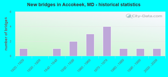
- New bridges - historical statistics
- 11920-1929
- 11940-1949
- 21950-1959
- 31960-1969
- 41970-1979
- 11980-1989
- 11990-1999
- 12000-2009


- Bridge Condition - Deck
- 66.7%Good
- 33.3%Fair

- Bridge Condition - Superstructure
- 33.3%Satisfactory
- 66.7%Fair

- Bridge Condition - Channel
- 60.0%Good
- 20.0%Satisfactory
- 20.0%Fair
Find on map >> Show street view
Structure Number: 10000016003701, Location: 2.42 MILES N OF MD 373 (Lat: 38.698322, Lng: -76.986339), Route carried "on" structure: State highway 210, Year Built: 1946, Year Reconstructed: 1994, Status: Open, Structure Length: 5.97m (19.59ft), Average Daily Traffic: 49,700 (year 2009), Truck Traffic: 5%, Average Future Daily Traffic: 77,380 (year 2029), Design Load: HS 20, Features Intersected: PISCATAWAY CREEK
Minimum Vertical Clearance: 30+ m (98+ ft), Kilometerpoint: 9.348, Lanes on structure: 6, Base Highway Network: Yes, Owner: State Highway Agency, Approaching Roadway Width: 28.3m (92.8ft), Skew: 30 degrees, Material/Design: Steel, Design/Construction: Stringer/Multi-beam, Number Of Spans In Main Unit: 3, Length of Maximum Span: 27.4m (89.9ft), Curb-To-Curb Width: 33.3m (109.3ft), Out-to-Out Width: 35.8m (117.5ft)
Condition: Deck: Good, Superstructure: Fair, Substructure: Fair, Channel: Good, Operating Rating: 85.7 metric tons, Method Used To Determine Operating Rating: Load Factor (LF), Inventory Rating: 51.2 metric tons, Method Used To Determine Inventory Rating: Load Factor (LF), Structural Evaluation: Somewhat better than minimum adequacy, Deck Geometry: Superior to present desirable criteria, Waterway Adequacy: Superior to present desirable criteria, Approach Roadway Alignment: Equal to present desirable criteria, Length Of Structure Improvement: 5.91m (19.39ft), Designated Inspection Frequency: Every 24 months, Inspection Date: June 2020, Bridge Improvement Cost: $602,000, Roadway Improvement Cost: $60,000, Total Project Cost: $662,000, Deck Structure Type: Concrete Cast-file-Place, Wearing Surface/Protective System: Wearing Surface: Monolithic Concrete, Deck Protection: Epoxy Coated Reinforcing
Find on map >> Show street view
Structure Number: 10000016005201, Location: 0.1 MILE NORTH OF MD 223A (Lat: 38.705461, Lng: -76.966031), Route carried "on" structure: State highway 223, Year Built: 1974, Status: Open, Structure Length: 3.60m (11.81ft), Average Daily Traffic: 112 (year 2018), Truck Traffic: 8%, Average Future Daily Traffic: 112 (year 2038), Design Load: HS 20, Features Intersected: PISCATAWAY CREEK
Minimum Vertical Clearance: 30+ m (98+ ft), Kilometerpoint: 1.303, Lanes on structure: 2, Base Highway Network: Yes, Owner: State Highway Agency, Approaching Roadway Width: 13.4m (44.0ft), Material/Design: Steel continuous, Design/Construction: Stringer/Multi-beam, Number Of Spans In Main Unit: 3, Length of Maximum Span: 13.4m (44.0ft), Curb-To-Curb Width: 14.4m (47.2ft), Out-to-Out Width: 15.4m (50.5ft)
Condition: Deck: Good, Superstructure: Satisfactory, Substructure: Fair, Channel: Fair, Operating Rating: 63.0 metric tons, Method Used To Determine Operating Rating: Load Factor (LF), Inventory Rating: 37.6 metric tons, Method Used To Determine Inventory Rating: Load Factor (LF), Structural Evaluation: Somewhat better than minimum adequacy, Deck Geometry: Superior to present desirable criteria, Waterway Adequacy: Equal to present desirable criteria, Approach Roadway Alignment: Equal to present desirable criteria, Designated Inspection Frequency: Every 24 months, Underwater Inspection Frequency: Every 48 months, Inspection Date: October 2020, Underwater Inspection Date: December 2020, Deck Structure Type: Concrete Cast-file-Place, Wearing Surface/Protective System: Wearing Surface: Monolithic Concrete
Find on map >> Show street view
Structure Number: 200000BC121201, Location: 0.1 MI S OF FRANKLIN ST (Lat: 39.293742, Lng: -76.647339), Route carried "on" structure: State highway 43, Year Built: 1976, Status: Open, Structure Length: 8.05m (26.41ft), Average Daily Traffic: 18,450 (year 2007), Truck Traffic: 5%, Average Future Daily Traffic: 22,140 (year 2036), Design Load: HS 20, Features Intersected: I-170, Facility Carried by Structure: MONROE STREET
Minimum Vertical Clearance: 30+ m (98+ ft), Kilometerpoint: 0.000, Lanes on structure: 4, Lanes under structure: 6, Owner: City or Municipal Highway Agency, Approaching Roadway Width: 15.9m (52.2ft), Material/Design: Concrete continuous, Design/Construction: Box Beam or Girders - Single/Spread, Number Of Spans In Main Unit: 3, Length of Maximum Span: 31.1m (102.0ft), Curb or Sidewalk Widths: Left: 2.4m (7.9ft), Right: 2.4m (7.9ft), Curb-To-Curb Width: 15.9m (52.2ft), Out-to-Out Width: 23.8m (78.1ft)
Condition: Deck: Fair, Superstructure: Fair, Substructure: Fair, Operating Rating: 68.9 metric tons, Method Used To Determine Operating Rating: Load Factor (LF), Inventory Rating: 41.3 metric tons, Method Used To Determine Inventory Rating: Load Factor (LF), Structural Evaluation: Somewhat better than minimum adequacy, Deck Geometry: Meets minimum limits, Underclear: High priority of corrective action, Approach Roadway Alignment: Equal to present desirable criteria, Length Of Structure Improvement: 8.11m (26.61ft), Designated Inspection Frequency: Every 24 months, Inspection Date: June 2020, Bridge Improvement Cost: $166,000, Roadway Improvement Cost: $9,000, Total Project Cost: $175,000, Deck Structure Type: Concrete Cast-file-Place, Wearing Surface/Protective System: Wearing Surface: Bituminous
Find on map >> Show street view
Structure Number: 200000P-040403, Location: 2.66 MILES W OF MD 210 (Lat: 38.689211, Lng: -77.051764), Route carried "on" structure: County highway 228, Year Built: 1960, Status: Open, Structure Length: 0.64m (2.10ft), Average Daily Traffic: 857 (year 2019), Truck Traffic: 10%, Average Future Daily Traffic: 1,280 (year 2039), Design Load: H 20, Features Intersected: ACCOKEEK CREEK, Facility Carried by Structure: BRYAN POINT ROAD
Minimum Vertical Clearance: 30+ m (98+ ft), Kilometerpoint: 4.280, Lanes on structure: 2, Owner: County Highway Agency, Approaching Roadway Width: 7.9m (25.9ft), Material/Design: Steel, Design/Construction: Culvert, Length of Maximum Span: 3.0m (9.8ft)
Condition: Channel: Satisfactory, Culverts: Satisfactory, Operating Rating: 84.8 metric tons, Method Used To Determine Operating Rating: Load Factor (LF), Inventory Rating: 50.8 metric tons, Method Used To Determine Inventory Rating: Load Factor (LF), Structural Evaluation: Equal to present minimum criteria, Waterway Adequacy: Equal to present minimum criteria, Approach Roadway Alignment: Equal to present minimum criteria, Length Of Structure Improvement: 2.07m (6.79ft), Designated Inspection Frequency: Every 24 months, Inspection Date: January 2021
Find on map >> Show street view
Structure Number: 200000P-040503, Location: 1600 W OF LIVINGSTON ROAD (Lat: 38.691794, Lng: -76.984147), Route carried "on" structure: County highway , Year Built: 2005, Status: Open, Structure Length: 0.67m (2.20ft), Average Daily Traffic: 290 (year 2019), Truck Traffic: 5%, Average Future Daily Traffic: 320 (year 2039), Design Load: HS 25 or greater, Features Intersected: TRIBUTARY TO PISCATAWAY, Facility Carried by Structure: ST. JAMES ROAD
Minimum Vertical Clearance: 30+ m (98+ ft), Kilometerpoint: 0.000, Lanes on structure: 2, Owner: County Highway Agency, Approaching Roadway Width: 11.9m (39.0ft), Skew: 4 degrees, Material/Design: Concrete, Design/Construction: Culvert, Number Of Spans In Main Unit: 2, Length of Maximum Span: 2.4m (7.9ft)
Condition: Channel: Good, Culverts: Satisfactory, Structural Evaluation: Equal to present minimum criteria, Waterway Adequacy: Equal to present desirable criteria, Approach Roadway Alignment: Equal to present desirable criteria, Length Of Structure Improvement: 0.67m (2.20ft), Designated Inspection Frequency: Every 24 months, Inspection Date: May 2021
Find on map >> Show street view
Structure Number: 200000P-041102, Location: 0.6 MI EAST OF MD 210 (Lat: 38.641161, Lng: -77.030636), Route carried "on" structure: County highway 5979, Year Built: 1997, Status: Open, Structure Length: 0.98m (3.22ft), Average Daily Traffic: 1,308 (year 2021), Truck Traffic: 2%, Average Future Daily Traffic: 1,948 (year 2041), Design Load: HS 20, Features Intersected: TRIBUTARY TO MATTAWOMAN, Facility Carried by Structure: BOHAC LANE
Minimum Vertical Clearance: 30+ m (98+ ft), Kilometerpoint: 0.000, Lanes on structure: 2, Owner: County Highway Agency, Approaching Roadway Width: 11.0m (36.1ft), Material/Design: Concrete, Design/Construction: Culvert, Number Of Spans In Main Unit: 3, Length of Maximum Span: 3.4m (11.2ft), Curb or Sidewalk Widths: Left: 1.2m (3.9ft), Right: 0.0m
Condition: Channel: Good, Culverts: Satisfactory, Operating Rating: 32.7 metric tons, Method Used To Determine Operating Rating: Field evaluation and documented engineering judgment, Inventory Rating: 32.7 metric tons, Method Used To Determine Inventory Rating: Field evaluation and documented engineering judgment, Structural Evaluation: Equal to present minimum criteria, Waterway Adequacy: Equal to present desirable criteria, Approach Roadway Alignment: Equal to present desirable criteria, Designated Inspection Frequency: Every 24 months, Inspection Date: March 2021
Find on map >> Show street view
Structure Number: 200000BC110301, Location: 0.03 MI W OF NORTH AVE (Lat: 39.310200, Lng: -76.621778), Route carried "under" structure: US 1, Year Built: 1959, Structure Length: 0. m, Average Daily Traffic: 27,082 (year 2002), Truck Traffic: 5%, Features Intersected: CSXT RR AND NORTH AVENUE, Facility Carried by Structure: I-83
Minimum Vertical Clearance: 5.49m (18.01ft), Kilometerpoint: 22.220, Lanes on structure: 7, Lanes under structure: 4, Design/Construction: Stringer/Multi-beam, Length of Maximum Span: 58.2m (190.9ft)
Find on map >> Show street view
Structure Number: 200000BC120401, Location: 0.3 MI N MD STATE PEN (Lat: 39.304694, Lng: -76.611333), Route carried "under" structure: Interstate 83, Year Built: 1959, Structure Length: 0. m, Average Daily Traffic: 52,800 (year 2012), Features Intersected: I-83 & AMTRAK, Facility Carried by Structure: PRESTON ST
Minimum Vertical Clearance: 5.79m (19.00ft), Kilometerpoint: 3.315, Lanes on structure: 4, Lanes under structure: 6, Design/Construction: Stringer/Multi-beam, Length of Maximum Span: 31.1m (102.0ft)
Find on map >> Show street view
Structure Number: 200000BC140301, Location: 0.1 MI N OF MT ROYAL AVE (Lat: 39.306092, Lng: -76.613447), Route carried "under" structure: Interstate 83, Year Built: 1920, Structure Length: 0. m, Average Daily Traffic: 40,000 (year 2012), Features Intersected: I-83, AMTRAK, Facility Carried by Structure: CALVERT ST
Minimum Vertical Clearance: 30+ m (98+ ft), Kilometerpoint: 1.979, Lanes on structure: 4, Lanes under structure: 6, Design/Construction: Stringer/Multi-beam, Length of Maximum Span: 40.8m (133.9ft)
Find on map >> Show street view
Structure Number: 200000BC150101, Location: 0.03 MI S OF BIDDLE ST (Lat: 39.302889, Lng: -76.611114), Route carried "under" structure: City street 1382, Year Built: 1968, Structure Length: 0. m, Average Daily Traffic: 15,374 (year 0000), Features Intersected: I-83 & PARKING LOTS, Facility Carried by Structure: FALLSWAY
Minimum Vertical Clearance: 4.57m (14.99ft), Kilometerpoint: 1.545, Lanes on structure: 3, Lanes under structure: 6, Design/Construction: Box Beam or Girders - Multiple, Length of Maximum Span: 26.2m (86.0ft)
Find on map >> Show street view
Structure Number: 200000BC320901, Location: 1.5 MI N COLD SPRING LANE (Lat: 39.360533, Lng: -76.650081), Route carried "under" structure: Interstate 83, Year Built: 1962, Structure Length: 0. m, Average Daily Traffic: 25,727 (year 0000), Features Intersected: I-83 & JONES FALLS, Facility Carried by Structure: NORTHERN PKWY
Minimum Vertical Clearance: 8.23m (27.00ft), Kilometerpoint: 9.429, Lanes on structure: 5, Lanes under structure: 7, Design/Construction: Stringer/Multi-beam, Length of Maximum Span: 54.0m (177.2ft)
Find on map >> Show street view
Structure Number: 200000BC420101, Location: 0.2 MI N OF IS 895 (Lat: 39.301106, Lng: -76.550561), Route carried "under" structure: US 40, Year Built: 1985, Structure Length: 0. m, Average Daily Traffic: 42,200 (year 2012), Features Intersected: PULASKI HIGHWAY, Facility Carried by Structure: ERDMAN AVENUE
Minimum Vertical Clearance: 4.88m (16.01ft), Kilometerpoint: 1608.984, Lanes on structure: 6, Lanes under structure: 7, Design/Construction: Culvert, Length of Maximum Span: 21.3m (69.9ft)
Find on map >> Show street view
Structure Number: 300000BCW51901, Location: 0.41 MI S OF CATON AVE (Lat: 0.654233, Lng: -1.277828), Route carried "under" structure: Interstate 95, Year Built: 1971, Structure Length: 0. m, Average Daily Traffic: 1,229 (year 2010), Truck Traffic: 7%, Features Intersected: IS 95, Facility Carried by Structure: JOH AVENUE
Minimum Vertical Clearance: 4.88m (16.01ft), Kilometerpoint: 0.064, Lanes on structure: 4, Lanes under structure: 8, Material/Design: Concrete continuous, Design/Construction: Box Beam or Girders - Multiple, Length of Maximum Span: 36.0m (118.1ft)
Find on map >> Show street view
Structure Number: 300000BCW58601, Location: MILEPOST 58.6 (Lat: 0.654772, Lng: -1.275556), Route carried "under" structure: Interstate 150, Year Built: 1971, Structure Length: 0. m, Average Daily Traffic: 125,751 (year 2010), Truck Traffic: 10%, Features Intersected: IS 95, Facility Carried by Structure: EASTERN AVENUE
Minimum Vertical Clearance: 4.88m (16.01ft), Kilometerpoint: 14.047, Lanes on structure: 6, Lanes under structure: 10, Material/Design: Prestressed concrete continuous, Design/Construction: Box Beam or Girders - Multiple, Length of Maximum Span: 50.3m (165.0ft)