Bridge Statistics for Aberdeen, Maryland (MD)
Condition, Traffic, Stress, Structural Evaluation, Project Costs
- National Bridge Inventory (NBI) Statistics
- 32Number of bridges
- 364ft / 111mTotal length
- $18,618,000Total costs
- 925,529Total average daily traffic
- 99,395Total average daily truck traffic
- National Bridge Inventory (NBI) Registered Bridges for Aberdeen
- No street view available for this location
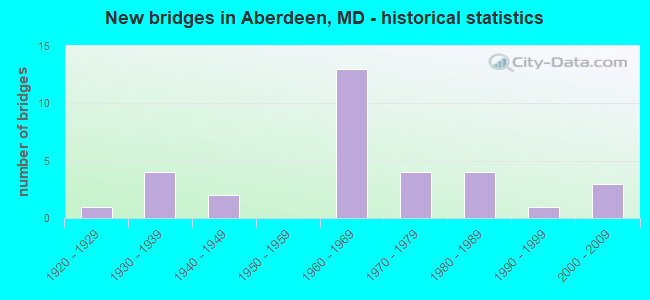
- New bridges - historical statistics
- 11920-1929
- 41930-1939
- 21940-1949
- 131960-1969
- 41970-1979
- 41980-1989
- 11990-1999
- 32000-2009

- Reconstructed bridges - Historical Statistics
- 11940-1949
- 01950-1959
- 31960-1969
- 01970-1979
- 31980-1989
- 11990-1999
- 12000-2009
- 12010-2019


- Bridge Condition - Deck
- 9.5%Very good
- 33.3%Good
- 33.3%Satisfactory
- 23.8%Fair

- Bridge Condition - Superstructure
- 14.3%Very good
- 28.6%Good
- 33.3%Satisfactory
- 23.8%Fair

- Bridge Condition - Substructure
- 4.8%Very good
- 28.6%Good
- 47.6%Satisfactory
- 19.0%Fair

- Bridge Condition - Channel
- 5.9%Very good
- 23.5%Good
- 64.7%Satisfactory
- 5.9%Fair

- Bridge Condition - Culverts
- 42.9%Good
- 28.6%Satisfactory
- 28.6%Fair
Find on map >> Show street view
Structure Number: 10000012000501, Location: 0.06 MILE EAST OF US 40 (Lat: 39.514853, Lng: -76.157594), Route carried "on" structure: State highway 22, Year Built: 1968, Year Reconstructed: 1971, Status: Open, Structure Length: 3.57m (11.71ft), Average Daily Traffic: 22,420 (year 2018), Truck Traffic: 8%, Average Future Daily Traffic: 33,315 (year 2038), Design Load: HS 20, Features Intersected: AMTRAK, TRIB TO SWAN CR
Minimum Vertical Clearance: 30+ m (98+ ft), Kilometerpoint: 19.128, Lanes on structure: 4, Base Highway Network: Yes, Owner: State Highway Agency, Approaching Roadway Width: 30.5m (100.1ft), Skew: 21 degrees, Material/Design: Steel, Design/Construction: Stringer/Multi-beam, Number Of Spans In Main Unit: 2, Length of Maximum Span: 27.4m (89.9ft), Curb-To-Curb Width: 27.7m (90.9ft), Out-to-Out Width: 28.7m (94.2ft)
Condition: Deck: Satisfactory, Superstructure: Fair, Substructure: Satisfactory, Channel: Very good, Operating Rating: 68.5 metric tons, Method Used To Determine Operating Rating: Load Factor (LF), Inventory Rating: 41.3 metric tons, Method Used To Determine Inventory Rating: Load Factor (LF), Structural Evaluation: Somewhat better than minimum adequacy, Deck Geometry: Superior to present desirable criteria, Underclear: Better than present minimum criteria, Waterway Adequacy: Superior to present desirable criteria, Approach Roadway Alignment: Equal to present desirable criteria, Length Of Structure Improvement: 3.57m (11.71ft), Designated Inspection Frequency: Every 24 months, Inspection Date: November 2020, Deck Structure Type: Concrete Cast-file-Place, Wearing Surface/Protective System: Wearing Surface: Low Slump Concrete
Find on map >> Show street view
Structure Number: 10000012000701, Location: 0.34 MILE SOUTH OF US 40 (Lat: 39.491017, Lng: -76.203397), Route carried "on" structure: State highway 7, Year Built: 1993, Status: Open, Structure Length: 4.11m (13.48ft), Average Daily Traffic: 12,210 (year 2009), Truck Traffic: 8%, Average Future Daily Traffic: 14,678 (year 2026), Design Load: HS 25 or greater, Features Intersected: CSX TRANS.
Minimum Vertical Clearance: 30+ m (98+ ft), Kilometerpoint: 17.667, Lanes on structure: 2, Owner: State Highway Agency, Approaching Roadway Width: 12.2m (40.0ft), Skew: 1 degrees, Material/Design: Steel, Design/Construction: Girder and Floorbeam System, Number Of Spans In Main Unit: 1, Length of Maximum Span: 39.6m (129.9ft), Curb-To-Curb Width: 12.2m (40.0ft), Out-to-Out Width: 13.2m (43.3ft)
Condition: Deck: Good, Superstructure: Very good, Substructure: Good, Operating Rating: 73.0 metric tons, Method Used To Determine Operating Rating: Load Factor (LF), Inventory Rating: 44.0 metric tons, Method Used To Determine Inventory Rating: Load Factor (LF), Structural Evaluation: Better than present minimum criteria, Deck Geometry: Somewhat better than minimum adequacy, Underclear: Better than present minimum criteria, Approach Roadway Alignment: Equal to present desirable criteria, Designated Inspection Frequency: Every 24 months, Inspection Date: August 2021, Deck Structure Type: Concrete Cast-file-Place, Wearing Surface/Protective System: Wearing Surface: Integral Concrete, Deck Protection: Epoxy Coated Reinforcing
Find on map >> Show street view
Structure Number: 10000012001301, Location: 0.33 MILE SOUTH OF US 40 (Lat: 39.520314, Lng: -76.140006), Route carried "on" structure: State highway 132B, Year Built: 1930, Status: Open, Structure Length: 1.22m (4.00ft), Average Daily Traffic: 4,030 (year 2009), Truck Traffic: 8%, Average Future Daily Traffic: 4,877 (year 2026), Features Intersected: SWAN CREEK
Minimum Vertical Clearance: 30+ m (98+ ft), Kilometerpoint: 1.770, Lanes on structure: 2, Owner: State Highway Agency, Approaching Roadway Width: 7.3m (24.0ft), Material/Design: Concrete, Design/Construction: Tee Beam, Number Of Spans In Main Unit: 1, Length of Maximum Span: 11.0m (36.1ft), Curb-To-Curb Width: 6.7m (22.0ft), Out-to-Out Width: 7.3m (24.0ft)
Condition: Deck: Fair, Superstructure: Fair, Substructure: Fair, Channel: Satisfactory, Operating Rating: 59.4 metric tons, Method Used To Determine Operating Rating: Load Factor (LF), Inventory Rating: 35.8 metric tons, Method Used To Determine Inventory Rating: Load Factor (LF), Structural Evaluation: Somewhat better than minimum adequacy, Deck Geometry: High priority of replacement, Waterway Adequacy: Equal to present minimum criteria, Approach Roadway Alignment: Equal to present desirable criteria, Length Of Structure Improvement: 1.22m (4.00ft), Designated Inspection Frequency: Every 24 months, Inspection Date: August 2020, Bridge Improvement Cost: $58,000, Roadway Improvement Cost: $6,000, Total Project Cost: $64,000, Deck Structure Type: Concrete Cast-file-Place, Wearing Surface/Protective System: Wearing Surface: Bituminous
Find on map >> Show street view
Structure Number: 10000012002201, Location: 0.26 MILE WEST OF MD 132B (Lat: 39.522628, Lng: -76.142336), Route carried "on" structure: US 40, Year Built: 1935, Status: Open, Structure Length: 1.28m (4.20ft), Average Daily Traffic: 27,800 (year 2009), Truck Traffic: 8%, Average Future Daily Traffic: 33,068 (year 2026), Design Load: HS 20, Features Intersected: SWAN CREEK
Minimum Vertical Clearance: 30+ m (98+ ft), Kilometerpoint: 23.491, Lanes on structure: 4, Base Highway Network: Yes, Owner: State Highway Agency, Approaching Roadway Width: 34.7m (113.8ft), Skew: 20 degrees, Material/Design: Concrete, Design/Construction: Tee Beam, Number Of Spans In Main Unit: 1, Length of Maximum Span: 12.2m (40.0ft), Curb-To-Curb Width: 33.5m (109.9ft), Out-to-Out Width: 34.7m (113.8ft)
Condition: Deck: Fair, Superstructure: Fair, Substructure: Fair, Channel: Satisfactory, Operating Rating: 51.2 metric tons, Method Used To Determine Operating Rating: Load Factor (LF), Inventory Rating: 30.8 metric tons, Method Used To Determine Inventory Rating: Load Factor (LF), Structural Evaluation: Somewhat better than minimum adequacy, Deck Geometry: Superior to present desirable criteria, Waterway Adequacy: Superior to present desirable criteria, Approach Roadway Alignment: Equal to present desirable criteria, Length Of Structure Improvement: 1.28m (4.20ft), Designated Inspection Frequency: Every 12 months, Inspection Date: April 2021, Bridge Improvement Cost: $287,000, Roadway Improvement Cost: $29,000, Total Project Cost: $316,000, Deck Structure Type: Concrete Cast-file-Place, Wearing Surface/Protective System: Wearing Surface: Bituminous
Find on map >> Show street view
Structure Number: 10000012002301, Location: 2 MILES WEST OF MD 22 (Lat: 39.493881, Lng: -76.183664), Route carried "on" structure: State highway 715, Year Built: 1985, Year Reconstructed: 2013, Status: Open, Structure Length: 6.37m (20.90ft), Average Daily Traffic: 11,583 (year 2012), Truck Traffic: 8%, Average Future Daily Traffic: 15,058 (year 2032), Design Load: HS 20, Features Intersected: US 40
Minimum Vertical Clearance: 30+ m (98+ ft), Kilometerpoint: 0.434, Lanes on structure: 5, Lanes under structure: 4, Owner: State Highway Agency, Approaching Roadway Width: 22.6m (74.1ft), Skew: 23 degrees, Material/Design: Steel, Design/Construction: Stringer/Multi-beam, Number Of Spans In Main Unit: 2, Length of Maximum Span: 31.1m (102.0ft), Curb-To-Curb Width: 21.9m (71.9ft), Out-to-Out Width: 23.8m (78.1ft)
Condition: Deck: Satisfactory, Superstructure: Satisfactory, Substructure: Good, Operating Rating: 89.3 metric tons, Method Used To Determine Operating Rating: Load Factor (LF), Inventory Rating: 53.5 metric tons, Method Used To Determine Inventory Rating: Load Factor (LF), Structural Evaluation: Equal to present minimum criteria, Deck Geometry: Somewhat better than minimum adequacy, Underclear: Equal to present minimum criteria, Approach Roadway Alignment: Equal to present desirable criteria, Designated Inspection Frequency: Every 24 months, Inspection Date: April 2021, Deck Structure Type: Concrete Cast-file-Place, Wearing Surface/Protective System: Wearing Surface: Monolithic Concrete, Deck Protection: Epoxy Coated Reinforcing
Find on map >> Show street view
Structure Number: 10000012002401, Location: 0.32 MILE EAST OF MD 159 (Lat: 39.490647, Lng: -76.192094), Route carried "on" structure: US 40, Year Built: 1935, Year Reconstructed: 2018, Status: Open, Structure Length: 1.01m (3.31ft), Average Daily Traffic: 34,600 (year 2009), Truck Traffic: 9%, Average Future Daily Traffic: 42,000 (year 2029), Design Load: HS 20, Features Intersected: CRANBERRY RUN
Minimum Vertical Clearance: 30+ m (98+ ft), Kilometerpoint: 17.747, Lanes on structure: 7, Base Highway Network: Yes, Owner: State Highway Agency, Approaching Roadway Width: 38.7m (127.0ft), Skew: 33 degrees, Material/Design: Steel, Design/Construction: Stringer/Multi-beam, Number Of Spans In Main Unit: 1, Length of Maximum Span: 8.2m (26.9ft), Curb-To-Curb Width: 3.9m (12.8ft), Out-to-Out Width: 4.1m (13.5ft)
Condition: Deck: Good, Superstructure: Good, Substructure: Satisfactory, Channel: Satisfactory, Operating Rating: 73.0 metric tons, Method Used To Determine Operating Rating: Load Factor (LF), Inventory Rating: 43.5 metric tons, Method Used To Determine Inventory Rating: Load Factor (LF), Structural Evaluation: Equal to present minimum criteria, Deck Geometry: High priority of replacement, Waterway Adequacy: Equal to present desirable criteria, Approach Roadway Alignment: Equal to present desirable criteria, Length Of Structure Improvement: 1.01m (3.31ft), Designated Inspection Frequency: Every 24 months, Inspection Date: December 2021, Bridge Improvement Cost: $1,592,000, Roadway Improvement Cost: $5,927,000, Total Project Cost: $17,777,000 ( Estimate for 2019), Deck Structure Type: Concrete Cast-file-Place, Wearing Surface/Protective System: Wearing Surface: Monolithic Concrete, Deck Protection: Epoxy Coated Reinforcing
Find on map >> Show street view
Structure Number: 10000012003501, Location: 0.39 MILE WEST OF MD 132B (Lat: 39.515792, Lng: -76.158772), Route carried "on" structure: State highway 22, Year Built: 1968, Year Reconstructed: 1971, Status: Open, Structure Length: 7.35m (24.11ft), Average Daily Traffic: 17,370 (year 2009), Truck Traffic: 8%, Average Future Daily Traffic: 18,430 (year 2029), Design Load: HS 20, Features Intersected: US 40
Minimum Vertical Clearance: 30+ m (98+ ft), Kilometerpoint: 19.051, Lanes on structure: 5, Lanes under structure: 4, Base Highway Network: Yes, Owner: State Highway Agency, Approaching Roadway Width: 30.5m (100.1ft), Skew: 20 degrees, Material/Design: Steel, Design/Construction: Stringer/Multi-beam, Number Of Spans In Main Unit: 4, Length of Maximum Span: 18.6m (61.0ft), Curb-To-Curb Width: 27.7m (90.9ft), Out-to-Out Width: 28.3m (92.8ft)
Condition: Deck: Fair, Superstructure: Satisfactory, Substructure: Satisfactory, Operating Rating: 44.0 metric tons, Method Used To Determine Operating Rating: Load Factor (LF), Inventory Rating: 43.5 metric tons, Method Used To Determine Inventory Rating: Load Factor (LF), Structural Evaluation: Equal to present minimum criteria, Deck Geometry: Superior to present desirable criteria, Underclear: Somewhat better than minimum adequacy, Approach Roadway Alignment: Equal to present desirable criteria, Designated Inspection Frequency: Every 24 months, Inspection Date: June 2020, Deck Structure Type: Concrete Cast-file-Place, Wearing Surface/Protective System: Wearing Surface: Low Slump Concrete
Find on map >> Show street view
Structure Number: 10000012003803, Location: 0.54 MILE WEST OF MD 155 (Lat: 39.566661, Lng: -76.182125), Route carried "on" structure: State highway 156, Year Built: 1922, Status: Open, Structure Length: 0.88m (2.89ft), Average Daily Traffic: 970 (year 2009), Truck Traffic: 8%, Average Future Daily Traffic: 1,015 (year 2026), Features Intersected: SWAN CREEK
Minimum Vertical Clearance: 30+ m (98+ ft), Kilometerpoint: 5.438, Lanes on structure: 2, Owner: State Highway Agency, Approaching Roadway Width: 5.5m (18.0ft), Skew: 4 degrees, Material/Design: Steel, Design/Construction: Culvert, Length of Maximum Span: 1.5m (4.9ft)
Condition: Channel: Satisfactory, Culverts: Fair, Operating Rating: 81.6 metric tons, Method Used To Determine Operating Rating: Allowable Stress (AS), Inventory Rating: 59.0 metric tons, Method Used To Determine Inventory Rating: Allowable Stress (AS), Structural Evaluation: Somewhat better than minimum adequacy, Waterway Adequacy: Better than present minimum criteria, Approach Roadway Alignment: Equal to present desirable criteria, Designated Inspection Frequency: Every 24 months, Inspection Date: April 2020
Find on map >> Show street view
Structure Number: 10000012004701, Location: 0.66 MILE NORTH OF MD 22 (Lat: 39.531442, Lng: -76.168892), Route carried "on" structure: State highway 462, Year Built: 1978, Status: Open, Structure Length: 1.95m (6.40ft), Average Daily Traffic: 6,960 (year 2009), Truck Traffic: 8%, Average Future Daily Traffic: 7,840 (year 2026), Design Load: HS 20+Mod, Features Intersected: CARSINS RUN
Minimum Vertical Clearance: 30+ m (98+ ft), Kilometerpoint: 2.108, Lanes on structure: 2, Owner: State Highway Agency, Approaching Roadway Width: 13.4m (44.0ft), Material/Design: Concrete, Design/Construction: Slab, Number Of Spans In Main Unit: 1, Length of Maximum Span: 18.3m (60.0ft), Curb or Sidewalk Widths: Left: 1.5m (4.9ft), Right: 1.5m (4.9ft), Curb-To-Curb Width: 11.1m (36.4ft), Out-to-Out Width: 14.7m (48.2ft)
Condition: Deck: Satisfactory, Superstructure: Satisfactory, Substructure: Good, Channel: Satisfactory, Operating Rating: 78.5 metric tons, Method Used To Determine Operating Rating: Load Factor (LF), Inventory Rating: 47.2 metric tons, Method Used To Determine Inventory Rating: Load Factor (LF), Structural Evaluation: Equal to present minimum criteria, Deck Geometry: Meets minimum limits, Waterway Adequacy: Superior to present desirable criteria, Approach Roadway Alignment: Equal to present desirable criteria, Designated Inspection Frequency: Every 24 months, Inspection Date: January 2022, Deck Structure Type: Concrete Cast-file-Place, Wearing Surface/Protective System: Wearing Surface: Monolithic Concrete
Find on map >> Show street view
Structure Number: 10000012004802, Location: 0.84 MILE NORTH OF MD 22 (Lat: 39.534086, Lng: -76.168058), Route carried "on" structure: State highway 462, Year Built: 1978, Status: Open, Structure Length: 1.20m (3.94ft), Average Daily Traffic: 7,401 (year 2013), Truck Traffic: 8%, Average Future Daily Traffic: 7,840 (year 2026), Design Load: HS 20+Mod, Features Intersected: SWAN CREEK
Minimum Vertical Clearance: 30+ m (98+ ft), Kilometerpoint: 2.397, Lanes on structure: 2, Owner: State Highway Agency, Approaching Roadway Width: 13.4m (44.0ft), Skew: 3 degrees, Material/Design: Concrete, Design/Construction: Culvert, Length of Maximum Span: 5.8m (19.0ft)
Condition: Channel: Satisfactory, Culverts: Satisfactory, Operating Rating: 32.7 metric tons, Method Used To Determine Operating Rating: Field evaluation and documented engineering judgment, Inventory Rating: 32.7 metric tons, Method Used To Determine Inventory Rating: Field evaluation and documented engineering judgment, Structural Evaluation: Equal to present minimum criteria, Waterway Adequacy: Equal to present desirable criteria, Approach Roadway Alignment: Equal to present desirable criteria, Designated Inspection Frequency: Every 24 months, Inspection Date: Febuary 2020, Deck Structure Type: Concrete Cast-file-Place, Wearing Surface/Protective System: Wearing Surface: Monolithic Concrete
Find on map >> Show street view
Structure Number: 100000120058013, Location: 0.51 MILE EAST OF US 40 (Lat: 39.490694, Lng: -76.175778), Route carried "on" structure: State highway 715, Year Built: 1943, Year Reconstructed: 1985, Status: Open, Structure Length: 5.49m (18.01ft), Average Daily Traffic: 8,627 (year 2018), Truck Traffic: 8%, Average Future Daily Traffic: 12,820 (year 2038), Design Load: HS 20, Features Intersected: AMTRAK
Minimum Vertical Clearance: 30+ m (98+ ft), Kilometerpoint: 1.255, Lanes on structure: 2, Owner: State Highway Agency, Approaching Roadway Width: 10.4m (34.1ft), Skew: 1 degrees, Material/Design: Steel, Design/Construction: Stringer/Multi-beam, Number Of Spans In Main Unit: 3, Length of Maximum Span: 21.6m (70.9ft), Curb-To-Curb Width: 11.0m (36.1ft), Out-to-Out Width: 11.9m (39.0ft)
Condition: Deck: Good, Superstructure: Satisfactory, Substructure: Fair, Inventory Rating: 54.4 metric tons, Method Used To Determine Inventory Rating: Load Factor (LF), Structural Evaluation: Somewhat better than minimum adequacy, Deck Geometry: Equal to present minimum criteria, Underclear: Somewhat better than minimum adequacy, Approach Roadway Alignment: Equal to present desirable criteria, Length Of Structure Improvement: 5.49m (18.01ft), Designated Inspection Frequency: Every 24 months, Inspection Date: September 2020, Deck Structure Type: Concrete Cast-file-Place, Wearing Surface/Protective System: Wearing Surface: Monolithic Concrete, Deck Protection: Epoxy Coated Reinforcing
Find on map >> Show street view
Structure Number: 10000012006101, Location: 0.03 MILE SOUTH OF US 40 (Lat: 39.523906, Lng: -76.137753), Route carried "on" structure: State highway 132B, Year Built: 1943, Year Reconstructed: 1972, Status: Open, Structure Length: 4.18m (13.71ft), Average Daily Traffic: 3,563 (year 2018), Truck Traffic: 8%, Average Future Daily Traffic: 4,350 (year 2038), Design Load: HS 20, Features Intersected: AMTRAK
Minimum Vertical Clearance: 30+ m (98+ ft), Kilometerpoint: 2.253, Lanes on structure: 2, Owner: State Highway Agency, Approaching Roadway Width: 6.4m (21.0ft), Material/Design: Concrete continuous, Design/Construction: Slab, Number Of Spans In Main Unit: 3, Length of Maximum Span: 19.8m (65.0ft), Curb-To-Curb Width: 6.7m (22.0ft), Out-to-Out Width: 7.8m (25.6ft)
Condition: Deck: Fair, Superstructure: Fair, Substructure: Fair, Operating Rating: 55.8 metric tons, Method Used To Determine Operating Rating: Load Factor (LF), Inventory Rating: 33.6 metric tons, Method Used To Determine Inventory Rating: Load Factor (LF), Structural Evaluation: Somewhat better than minimum adequacy, Deck Geometry: High priority of replacement, Underclear: High priority of replacement, Approach Roadway Alignment: Equal to present desirable criteria, Length Of Structure Improvement: 4.18m (13.71ft), Designated Inspection Frequency: Every 24 months, Inspection Date: October 2020, Bridge Improvement Cost: $419,000, Roadway Improvement Cost: $42,000, Total Project Cost: $461,000, Deck Structure Type: Concrete Cast-file-Place, Wearing Surface/Protective System: Wearing Surface: Monolithic Concrete
Find on map >> Show street view
Structure Number: 10000012006801, Location: 0.06 MILE WEST OF US 40 (Lat: 39.516214, Lng: -76.159231), Route carried "on" structure: State highway 22, Year Built: 1968, Status: Open, Structure Length: 1.74m (5.71ft), Average Daily Traffic: 25,940 (year 0009), Truck Traffic: 8%, Average Future Daily Traffic: 29,700 (year 0029), Design Load: HS 20, Features Intersected: CSX TRANS.
Minimum Vertical Clearance: 30+ m (98+ ft), Kilometerpoint: 18.964, Lanes on structure: 6, Base Highway Network: Yes, Owner: State Highway Agency, Approaching Roadway Width: 34.1m (111.9ft), Skew: 21 degrees, Material/Design: Steel, Design/Construction: Stringer/Multi-beam, Number Of Spans In Main Unit: 1, Length of Maximum Span: 16.2m (53.1ft), Curb-To-Curb Width: 29.9m (98.1ft), Out-to-Out Width: 30.5m (100.1ft)
Condition: Deck: Satisfactory, Superstructure: Satisfactory, Substructure: Satisfactory, Operating Rating: 80.3 metric tons, Method Used To Determine Operating Rating: Load Factor (LF), Inventory Rating: 48.1 metric tons, Method Used To Determine Inventory Rating: Load Factor (LF), Structural Evaluation: Equal to present minimum criteria, Deck Geometry: Superior to present desirable criteria, Underclear: Better than present minimum criteria, Approach Roadway Alignment: Equal to present desirable criteria, Designated Inspection Frequency: Every 24 months, Inspection Date: August 2021, Deck Structure Type: Concrete Cast-file-Place, Wearing Surface/Protective System: Wearing Surface: Bituminous
Find on map >> Show street view
Structure Number: 10000012006902, Location: 0.03 MILE SOUTH OF MD 22 (Lat: 39.514597, Lng: -76.159756), Route carried "on" structure: US 40, Year Built: 1968, Status: Open, Structure Length: 0.84m (2.76ft), Average Daily Traffic: 26,751 (year 2013), Truck Traffic: 8%, Average Future Daily Traffic: 29,563 (year 2026), Design Load: HS 20, Features Intersected: BR OF SWAN CREEK
Minimum Vertical Clearance: 30+ m (98+ ft), Kilometerpoint: 21.850, Lanes on structure: 7, Base Highway Network: Yes, Owner: State Highway Agency, Approaching Roadway Width: 164.6m (540.0ft), Skew: 11 degrees, Material/Design: Concrete, Design/Construction: Culvert, Length of Maximum Span: 2.7m (8.9ft)
Condition: Channel: Good, Culverts: Satisfactory, Operating Rating: 60.8 metric tons, Method Used To Determine Operating Rating: Load Factor (LF), Inventory Rating: 41.7 metric tons, Method Used To Determine Inventory Rating: Load Factor (LF), Structural Evaluation: Equal to present minimum criteria, Waterway Adequacy: Equal to present minimum criteria, Approach Roadway Alignment: Equal to present desirable criteria, Designated Inspection Frequency: Every 24 months, Inspection Date: June 2020
Find on map >> Show street view
Structure Number: 10000012007402, Location: 0.27 MILE SOUTH OF IS 95 (Lat: 39.542547, Lng: -76.166403), Route carried "on" structure: State highway 462, Year Built: 1978, Status: Open, Structure Length: 0.67m (2.20ft), Average Daily Traffic: 6,501 (year 2013), Truck Traffic: 8%, Average Future Daily Traffic: 7,102 (year 2026), Design Load: HS 20+Mod, Features Intersected: SWAN CREEK
Minimum Vertical Clearance: 30+ m (98+ ft), Kilometerpoint: 3.379, Lanes on structure: 2, Owner: State Highway Agency, Approaching Roadway Width: 14.0m (45.9ft), Skew: 3 degrees, Material/Design: Concrete, Design/Construction: Culvert, Length of Maximum Span: 3.0m (9.8ft)
Condition: Channel: Satisfactory, Culverts: Good, Operating Rating: 32.7 metric tons, Method Used To Determine Operating Rating: Field evaluation and documented engineering judgment, Inventory Rating: 32.7 metric tons, Method Used To Determine Inventory Rating: Field evaluation and documented engineering judgment, Structural Evaluation: Better than present minimum criteria, Waterway Adequacy: Equal to present minimum criteria, Approach Roadway Alignment: Equal to present desirable criteria, Designated Inspection Frequency: Every 24 months, Inspection Date: January 2022, Deck Structure Type: Concrete Cast-file-Place, Wearing Surface/Protective System: Wearing Surface: Monolithic Concrete
Find on map >> Show street view
Structure Number: 10000012007501, Location: 0.19 MILE EAST OF US 40 (Lat: 39.505964, Lng: -76.163861), Route carried "on" structure: State highway 132, Year Built: 1983, Status: Open, Structure Length: 25.30m (83.01ft), Average Daily Traffic: 3,900 (year 2009), Truck Traffic: 8%, Average Future Daily Traffic: 4,312 (year 2026), Design Load: HS 20, Features Intersected: AMTRAK
Minimum Vertical Clearance: 30+ m (98+ ft), Kilometerpoint: 3.234, Lanes on structure: 2, Owner: State Highway Agency, Approaching Roadway Width: 11.0m (36.1ft), Material/Design: Steel, Design/Construction: Stringer/Multi-beam, Number Of Spans In Main Unit: 9, Length of Maximum Span: 46.6m (152.9ft), Curb or Sidewalk Widths: Left: 1.5m (4.9ft), Right: 0.0m, Curb-To-Curb Width: 11.0m (36.1ft), Out-to-Out Width: 13.3m (43.6ft)
Condition: Deck: Fair, Superstructure: Fair, Substructure: Satisfactory, Operating Rating: 40.8 metric tons, Method Used To Determine Operating Rating: Load Factor (LF), Inventory Rating: 24.5 metric tons, Method Used To Determine Inventory Rating: Load Factor (LF), Structural Evaluation: Somewhat better than minimum adequacy, Deck Geometry: Somewhat better than minimum adequacy, Underclear: Better than present minimum criteria, Approach Roadway Alignment: Equal to present desirable criteria, Designated Inspection Frequency: Every 24 months, Inspection Date: May 2020, Deck Structure Type: Concrete Cast-file-Place, Wearing Surface/Protective System: Wearing Surface: Monolithic Concrete, Deck Protection: Epoxy Coated Reinforcing
Find on map >> Show street view
Structure Number: 200000H-001501, Location: 0.03 MILES N OF MD 22 (Lat: 39.537550, Lng: -76.212103), Route carried "on" structure: County highway 332, Year Built: 1972, Status: Posted for load, Structure Length: 1.10m (3.61ft), Average Daily Traffic: 655 (year 2019), Truck Traffic: 5%, Average Future Daily Traffic: 800 (year 2039), Design Load: HS 20, Features Intersected: CARSINS RUN, Facility Carried by Structure: CARSINS RUN ROAD
Minimum Vertical Clearance: 30+ m (98+ ft), Kilometerpoint: 6.275, Lanes on structure: 2, Owner: County Highway Agency, Approaching Roadway Width: 9.1m (29.9ft), Skew: 2 degrees, Material/Design: Steel, Design/Construction: Stringer/Multi-beam, Number Of Spans In Main Unit: 1, Length of Maximum Span: 10.1m (33.1ft), Curb-To-Curb Width: 9.1m (29.9ft), Out-to-Out Width: 10.1m (33.1ft)
Condition: Deck: Good, Superstructure: Good, Substructure: Satisfactory, Channel: Satisfactory, Operating Rating: 59.0 metric tons, Method Used To Determine Operating Rating: Load Factor (LF), Inventory Rating: 35.4 metric tons, Method Used To Determine Inventory Rating: Load Factor (LF), Structural Evaluation: Equal to present minimum criteria, Deck Geometry: Equal to present minimum criteria, Waterway Adequacy: Equal to present minimum criteria, Approach Roadway Alignment: Equal to present minimum criteria, Designated Inspection Frequency: Every 24 months, Inspection Date: July 2021, Deck Structure Type: Concrete Cast-file-Place, Wearing Surface/Protective System: Wearing Surface: Monolithic Concrete
Find on map >> Show street view
Structure Number: 200000H-001601, Location: 0.5 MILES N OF MD 22 (Lat: 39.539650, Lng: -76.198431), Route carried "on" structure: County highway 333, Year Built: 2000, Status: Open, Structure Length: 1.22m (4.00ft), Average Daily Traffic: 439 (year 2019), Truck Traffic: 5%, Average Future Daily Traffic: 561 (year 2039), Design Load: HS 25 or greater, Features Intersected: CARSINS RUN, Facility Carried by Structure: ALDINO-STEPNEY RD
Minimum Vertical Clearance: 30+ m (98+ ft), Kilometerpoint: 2.542, Lanes on structure: 2, Owner: County Highway Agency, Approaching Roadway Width: 7.3m (24.0ft), Material/Design: Prestressed concrete, Design/Construction: Box Beam or Girders - Multiple, Number Of Spans In Main Unit: 1, Length of Maximum Span: 11.0m (36.1ft), Curb-To-Curb Width: 8.1m (26.6ft), Out-to-Out Width: 8.8m (28.9ft)
Condition: Deck: Good, Superstructure: Very good, Substructure: Good, Channel: Good, Operating Rating: 62.6 metric tons, Method Used To Determine Operating Rating: Load Factor (LF), Inventory Rating: 37.2 metric tons, Method Used To Determine Inventory Rating: Load Factor (LF), Structural Evaluation: Better than present minimum criteria, Deck Geometry: Somewhat better than minimum adequacy, Waterway Adequacy: Equal to present minimum criteria, Approach Roadway Alignment: Somewhat better than minimum adequacy, Designated Inspection Frequency: Every 24 months, Inspection Date: September 2021, Deck Structure Type: Concrete Cast-file-Place, Wearing Surface/Protective System: Wearing Surface: Integral Concrete
Find on map >> Show street view
Structure Number: 200000H-001701, Location: 0.6 MILES S OF MD 156 (Lat: 39.559375, Lng: -76.180425), Route carried "on" structure: County highway 415, Year Built: 1930, Year Reconstructed: 1953, Status: Open, Structure Length: 1.05m (3.44ft), Average Daily Traffic: 365 (year 2019), Truck Traffic: 5%, Average Future Daily Traffic: 450 (year 2039), Features Intersected: SWAN CREEK, Facility Carried by Structure: WEST CHAPEL ROAD
Minimum Vertical Clearance: 30+ m (98+ ft), Kilometerpoint: 0.901, Lanes on structure: 2, Owner: County Highway Agency, Approaching Roadway Width: 6.1m (20.0ft), Skew: 3 degrees, Material/Design: Steel, Design/Construction: Stringer/Multi-beam, Number Of Spans In Main Unit: 1, Length of Maximum Span: 8.8m (28.9ft), Curb or Sidewalk Widths: Left: 0.3m (1.0ft), Right: 0.3m (1.0ft), Curb-To-Curb Width: 4.9m (16.1ft), Out-to-Out Width: 5.5m (18.0ft)
Condition: Deck: Very good, Superstructure: Very good, Substructure: Very good, Channel: Satisfactory, Operating Rating: 90.4 metric tons, Method Used To Determine Operating Rating: Load and Resistance Factor Rating (LRFR) rating reported by rating factor(RF) method using HL-93 loadings, Inventory Rating: 69.7 metric tons, Method Used To Determine Inventory Rating: Load and Resistance Factor Rating (LRFR) rating reported by rating factor(RF) method using HL-93 loadings, Structural Evaluation: Equal to present desirable criteria, Waterway Adequacy: Better than present minimum criteria, Approach Roadway Alignment: Somewhat better than minimum adequacy, Designated Inspection Frequency: Every 24 months, Inspection Date: November 2021, Deck Structure Type: Concrete Cast-file-Place, Wearing Surface/Protective System: Wearing Surface: Integral Concrete
Find on map >> Show street view
Structure Number: 200000H-019801, Location: 0.4 MIL E OF GLENVILLE RD (Lat: 39.572456, Lng: -76.230689), Route carried "on" structure: County highway 1878, Year Built: 1988, Year Reconstructed: 2021, Status: Posted for load, Structure Length: 0.98m (3.22ft), Average Daily Traffic: 102 (year 2020), Truck Traffic: 5%, Average Future Daily Traffic: 128 (year 2040), Design Load: HS 20, Features Intersected: MILL BROOK, Facility Carried by Structure: OAK FARM ROAD
Minimum Vertical Clearance: 30+ m (98+ ft), Kilometerpoint: 0.692, Lanes on structure: 2, Owner: County Highway Agency, Approaching Roadway Width: 7.3m (24.0ft), Skew: 2 degrees, Material/Design: Wood or Timber, Design/Construction: Slab, Number Of Spans In Main Unit: 1, Length of Maximum Span: 9.4m (30.8ft), Curb-To-Curb Width: 7.3m (24.0ft), Out-to-Out Width: 7.9m (25.9ft)
Condition: Deck: Very good, Superstructure: Good, Substructure: Satisfactory, Channel: Good, Operating Rating: 36.3 metric tons, Method Used To Determine Operating Rating: Allowable Stress (AS), Inventory Rating: 24.9 metric tons, Method Used To Determine Inventory Rating: Allowable Stress (AS), Structural Evaluation: Equal to present minimum criteria, Deck Geometry: Somewhat better than minimum adequacy, Waterway Adequacy: Superior to present desirable criteria, Approach Roadway Alignment: Equal to present minimum criteria, Bridge Posting: Required (Relationship of Operating Rating to Maximum Legal Load: 0.1 - 9.9% below), Designated Inspection Frequency: Every 24 months, Inspection Date: July 2021, Deck Structure Type: Wood or Timber, Wearing Surface/Protective System: Wearing Surface: Bituminous, Deck Protection: Other
Find on map >> Show street view
Structure Number: 200000H-020803, Location: 0.5 MILES N MD 22 (Lat: 39.535667, Lng: -76.189667), Route carried "on" structure: County highway 353, Year Built: 1960, Status: Open, Structure Length: 0.70m (2.30ft), Average Daily Traffic: 961 (year 2019), Truck Traffic: 5%, Average Future Daily Traffic: 1,173 (year 2039), Features Intersected: CARSINS RUN, Facility Carried by Structure: GILBERT ROAD
Minimum Vertical Clearance: 30+ m (98+ ft), Kilometerpoint: 0.000, Lanes on structure: 2, Owner: County Highway Agency, Approaching Roadway Width: 6.4m (21.0ft), Skew: 1 degrees, Material/Design: Steel, Design/Construction: Culvert, Number Of Spans In Main Unit: 3, Length of Maximum Span: 1.8m (5.9ft)
Condition: Channel: Fair, Culverts: Fair, Operating Rating: 53.1 metric tons, Method Used To Determine Operating Rating: Load Factor (LF), Inventory Rating: 37.6 metric tons, Method Used To Determine Inventory Rating: Load Factor (LF), Structural Evaluation: Somewhat better than minimum adequacy, Waterway Adequacy: Better than present minimum criteria, Approach Roadway Alignment: Equal to present minimum criteria, Designated Inspection Frequency: Every 24 months, Inspection Date: August 2021
Find on map >> Show street view
Structure Number: 300000H-X79901, Location: 6.9 MI N BALT-HAR CO LINE (Lat: 39.480258, Lng: -76.262247), Route carried "on" structure: Interstate 95, Year Built: 1963, Year Reconstructed: 2002, Status: Open, Structure Length: 4.42m (14.50ft), Average Daily Traffic: 130,492 (year 2019), Truck Traffic: 10%, Average Future Daily Traffic: 183,038 (year 2041), Design Load: HS 20, Features Intersected: JAMES RUN
Minimum Vertical Clearance: 30+ m (98+ ft), Kilometerpoint: 128.559, Lanes on structure: 6, Base Highway Network: Yes, Toll: On toll road, Owner: State Toll Authority, Approaching Roadway Width: 45.7m (149.9ft), Skew: 32 degrees, Material/Design: Steel, Design/Construction: Stringer/Multi-beam, Number Of Spans In Main Unit: 2, Length of Maximum Span: 21.3m (69.9ft), Curb-To-Curb Width: 45.7m (149.9ft), Out-to-Out Width: 47.3m (155.2ft)
Condition: Deck: Satisfactory, Superstructure: Satisfactory, Substructure: Satisfactory, Channel: Satisfactory, Operating Rating: 83.4 metric tons, Method Used To Determine Operating Rating: Load Factor (LF), Inventory Rating: 49.9 metric tons, Method Used To Determine Inventory Rating: Load Factor (LF), Structural Evaluation: Equal to present minimum criteria, Deck Geometry: Superior to present desirable criteria, Waterway Adequacy: Equal to present desirable criteria, Approach Roadway Alignment: Equal to present desirable criteria, Designated Inspection Frequency: Every 24 months, Inspection Date: December 2021, Deck Structure Type: Concrete Cast-file-Place, Wearing Surface/Protective System: Wearing Surface: Latex Concrete
Find on map >> Show street view
Structure Number: 300000H-X83701, Location: Milepost M83.7 (Lat: 39.513589, Lng: -76.206808), Route carried "on" structure: County highway 330, Year Built: 1963, Status: Open, Structure Length: 8.90m (29.20ft), Average Daily Traffic: 1,810 (year 2019), Truck Traffic: 5%, Average Future Daily Traffic: 2,157 (year 2041), Design Load: H 20, Features Intersected: I-95, Facility Carried by Structure: STEPNEY ROAD
Minimum Vertical Clearance: 30+ m (98+ ft), Kilometerpoint: 134.673, Lanes on structure: 2, Lanes under structure: 6, Owner: State Toll Authority, Approaching Roadway Width: 9.1m (29.9ft), Skew: 4 degrees, Material/Design: Steel, Design/Construction: Stringer/Multi-beam, Number Of Spans In Main Unit: 4, Length of Maximum Span: 30.5m (100.1ft), Curb or Sidewalk Widths: Left: 0.5m (1.6ft), Right: 0.5m (1.6ft), Curb-To-Curb Width: 9.1m (29.9ft), Out-to-Out Width: 10.7m (35.1ft)
Condition: Deck: Satisfactory, Superstructure: Good, Substructure: Satisfactory, Operating Rating: 53.5 metric tons, Method Used To Determine Operating Rating: Load Factor (LF), Inventory Rating: 32.2 metric tons, Method Used To Determine Inventory Rating: Load Factor (LF), Structural Evaluation: Equal to present minimum criteria, Deck Geometry: Somewhat better than minimum adequacy, Underclear: Somewhat better than minimum adequacy, Approach Roadway Alignment: Better than present minimum criteria, Designated Inspection Frequency: Every 24 months, Inspection Date: January 2020, Deck Structure Type: Concrete Cast-file-Place, Wearing Surface/Protective System: Wearing Surface: Monolithic Concrete
Find on map >> Show street view
Structure Number: 300000H-X84901, Location: Milepost M84.9 (Lat: 39.526769, Lng: -76.192508), Route carried "on" structure: State highway 22, Year Built: 2004, Status: Open, Structure Length: 10.49m (34.42ft), Average Daily Traffic: 28,033 (year 2019), Truck Traffic: 5%, Average Future Daily Traffic: 33,404 (year 2041), Design Load: HS 25 or greater, Features Intersected: I-95
Minimum Vertical Clearance: 30+ m (98+ ft), Kilometerpoint: 136.604, Lanes on structure: 6, Lanes under structure: 10, Base Highway Network: Yes, Owner: State Toll Authority, Approaching Roadway Width: 32.3m (106.0ft), Skew: 22 degrees, Material/Design: Steel continuous, Design/Construction: Stringer/Multi-beam, Number Of Spans In Main Unit: 3, Length of Maximum Span: 49.4m (162.1ft), Curb or Sidewalk Widths: Left: 1.5m (4.9ft), Right: 1.5m (4.9ft), Curb-To-Curb Width: 27.4m (89.9ft), Out-to-Out Width: 36.1m (118.4ft)
Condition: Deck: Good, Superstructure: Good, Substructure: Good, Inventory Rating: 54.9 metric tons, Method Used To Determine Inventory Rating: Load Factor (LF), Structural Evaluation: Better than present minimum criteria, Deck Geometry: Better than present minimum criteria, Underclear: Meets minimum limits, Approach Roadway Alignment: Equal to present desirable criteria, Designated Inspection Frequency: Every 24 months, Inspection Date: January 2020, Deck Structure Type: Concrete Cast-file-Place, Wearing Surface/Protective System: Wearing Surface: Monolithic Concrete, Deck Protection: Epoxy Coated Reinforcing
Find on map >> Show street view
Structure Number: 300000H-X85602, Location: Milepost M85.6 (Lat: 39.531367, Lng: -76.179767), Route carried "on" structure: Interstate 95, Year Built: 1963, Status: Open, Structure Length: 0.94m (3.08ft), Average Daily Traffic: 100,386 (year 2019), Truck Traffic: 18%, Average Future Daily Traffic: 133,377 (year 2041), Design Load: HS 20, Features Intersected: CARSINS RUN
Minimum Vertical Clearance: 30+ m (98+ ft), Kilometerpoint: 137.730, Lanes on structure: 6, Base Highway Network: Yes, Owner: State Toll Authority, Approaching Roadway Width: 43.9m (144.0ft), Material/Design: Concrete, Design/Construction: Culvert, Number Of Spans In Main Unit: 2, Length of Maximum Span: 4.6m (15.1ft)
Condition: Channel: Good, Culverts: Good, Operating Rating: 61.7 metric tons, Method Used To Determine Operating Rating: Load Factor (LF), Inventory Rating: 36.7 metric tons, Method Used To Determine Inventory Rating: Load Factor (LF), Structural Evaluation: Better than present minimum criteria, Waterway Adequacy: Superior to present desirable criteria, Approach Roadway Alignment: Equal to present desirable criteria, Designated Inspection Frequency: Every 24 months, Inspection Date: October 2021
Find on map >> Show street view
Structure Number: 300000H-X85901, Location: Milepost M85.9 (Lat: 39.534658, Lng: -76.176478), Route carried "on" structure: County highway 392, Year Built: 1963, Year Reconstructed: 1987, Status: Open, Structure Length: 7.71m (25.30ft), Average Daily Traffic: 1,239 (year 2019), Truck Traffic: 8%, Average Future Daily Traffic: 1,542 (year 2041), Design Load: H 20, Features Intersected: I-95, Facility Carried by Structure: MAXA ROAD
Minimum Vertical Clearance: 30+ m (98+ ft), Kilometerpoint: 138.213, Lanes on structure: 2, Lanes under structure: 6, Owner: State Toll Authority, Approaching Roadway Width: 8.5m (27.9ft), Skew: 2 degrees, Material/Design: Steel, Design/Construction: Stringer/Multi-beam, Number Of Spans In Main Unit: 4, Length of Maximum Span: 25.6m (84.0ft), Curb-To-Curb Width: 8.5m (27.9ft), Out-to-Out Width: 9.5m (31.2ft)
Condition: Deck: Good, Superstructure: Good, Substructure: Good, Operating Rating: 73.9 metric tons, Method Used To Determine Operating Rating: Load Factor (LF), Inventory Rating: 44.4 metric tons, Method Used To Determine Inventory Rating: Load Factor (LF), Structural Evaluation: Better than present minimum criteria, Deck Geometry: Somewhat better than minimum adequacy, Underclear: Meets minimum limits, Approach Roadway Alignment: Equal to present desirable criteria, Designated Inspection Frequency: Every 24 months, Inspection Date: January 2020, Deck Structure Type: Concrete Cast-file-Place, Wearing Surface/Protective System: Wearing Surface: Monolithic Concrete
Find on map >> Show street view
Structure Number: 300000H-X86302, Location: Milepost M86.3 (Lat: 39.539389, Lng: -76.172319), Route carried "on" structure: Interstate 95, Year Built: 1963, Status: Open, Structure Length: 0.94m (3.08ft), Average Daily Traffic: 100,386 (year 2019), Truck Traffic: 8%, Average Future Daily Traffic: 133,377 (year 2041), Design Load: HS 20, Features Intersected: SWAN CREEK
Minimum Vertical Clearance: 30+ m (98+ ft), Kilometerpoint: 138.857, Lanes on structure: 6, Base Highway Network: Yes, Owner: State Toll Authority, Approaching Roadway Width: 43.9m (144.0ft), Material/Design: Concrete, Design/Construction: Culvert, Number Of Spans In Main Unit: 2, Length of Maximum Span: 4.6m (15.1ft)
Condition: Channel: Satisfactory, Culverts: Good, Operating Rating: 32.7 metric tons, Method Used To Determine Operating Rating: Field evaluation and documented engineering judgment, Inventory Rating: 32.7 metric tons, Method Used To Determine Inventory Rating: Field evaluation and documented engineering judgment, Structural Evaluation: Better than present minimum criteria, Waterway Adequacy: Equal to present desirable criteria, Approach Roadway Alignment: Equal to present desirable criteria, Designated Inspection Frequency: Every 24 months, Inspection Date: January 2020
Find on map >> Show street view
Structure Number: 300000H-X86601, Location: Milepost M86.6 (Lat: 39.546239, Lng: -76.167039), Route carried "on" structure: Interstate 95, Year Built: 1963, Year Reconstructed: 1987, Status: Open, Structure Length: 5.73m (18.80ft), Average Daily Traffic: 95,675 (year 2019), Truck Traffic: 8%, Average Future Daily Traffic: 127,117 (year 2041), Design Load: HS 20, Features Intersected: MD 462
Minimum Vertical Clearance: 30+ m (98+ ft), Kilometerpoint: 139.339, Lanes on structure: 6, Lanes under structure: 2, Base Highway Network: Yes, Toll: On toll road, Owner: State Toll Authority, Approaching Roadway Width: 45.1m (148.0ft), Skew: 34 degrees, Material/Design: Steel, Design/Construction: Stringer/Multi-beam, Number Of Spans In Main Unit: 3, Length of Maximum Span: 26.5m (86.9ft), Curb-To-Curb Width: 44.1m (144.7ft), Out-to-Out Width: 46.1m (151.2ft)
Condition: Deck: Satisfactory, Superstructure: Satisfactory, Substructure: Satisfactory, Operating Rating: 84.8 metric tons, Method Used To Determine Operating Rating: Load Factor (LF), Inventory Rating: 50.8 metric tons, Method Used To Determine Inventory Rating: Load Factor (LF), Structural Evaluation: Equal to present minimum criteria, Deck Geometry: Superior to present desirable criteria, Underclear: Better than present minimum criteria, Approach Roadway Alignment: Equal to present desirable criteria, Designated Inspection Frequency: Every 24 months, Inspection Date: January 2020, Deck Structure Type: Concrete Cast-file-Place, Wearing Surface/Protective System: Wearing Surface: Monolithic Concrete
Find on map >> Show street view
Structure Number: 10000012002301, Location: 0.27 MI E OF US 40 (Lat: 39.493881, Lng: -76.183664), Route carried "under" structure: US 40, Year Built: 1985, Structure Length: 0. m, Average Daily Traffic: 33,610 (year 2012), Features Intersected: US 40, Facility Carried by Structure: MD 715
Minimum Vertical Clearance: 4.88m (16.01ft), Kilometerpoint: 18.536, Lanes on structure: 5, Lanes under structure: 4, Material/Design: Steel, Design/Construction: Stringer/Multi-beam, Length of Maximum Span: 31.1m (102.0ft)
Find on map >> Show street view
Structure Number: 10000012003501, Location: 0.51 MILE EAST OF MD 132 (Lat: 39.515792, Lng: -76.158772), Route carried "under" structure: US 40, Year Built: 1968, Structure Length: 0. m, Average Daily Traffic: 27,800 (year 2009), Features Intersected: US 40, Facility Carried by Structure: MD 22
Minimum Vertical Clearance: 8.53m (27.99ft), Kilometerpoint: 21.898, Lanes on structure: 5, Lanes under structure: 4, Material/Design: Steel, Design/Construction: Stringer/Multi-beam, Length of Maximum Span: 18.6m (61.0ft)
Find on map >> Show street view
Structure Number: 300000H-X83701, Location: Milepost M83.7 (Lat: 0.658467, Lng: -1.270067), Route carried "under" structure: Interstate 95, Year Built: 1963, Structure Length: 0. m, Average Daily Traffic: 93,575 (year 2010), Truck Traffic: 17%, Features Intersected: I-95, Facility Carried by Structure: CO0330
Minimum Vertical Clearance: 4.88m (16.01ft), Kilometerpoint: 17.554, Lanes on structure: 2, Lanes under structure: 6, Toll: On toll road, Material/Design: Steel, Design/Construction: Stringer/Multi-beam, Length of Maximum Span: 30.5m (100.1ft)
Find on map >> Show street view
Structure Number: 300000H-X84901, Location: MP 84.9 (Lat: 0.658711, Lng: -1.269806), Route carried "under" structure: Interstate 95, Year Built: 2004, Structure Length: 0. m, Average Daily Traffic: 89,375 (year 2010), Truck Traffic: 19%, Features Intersected: IS 95, Facility Carried by Structure: MD 22
Minimum Vertical Clearance: 5.49m (18.01ft), Kilometerpoint: 19.549, Lanes on structure: 6, Lanes under structure: 10, Toll: On toll road, Material/Design: Steel continuous, Design/Construction: Stringer/Multi-beam, Length of Maximum Span: 49.4m (162.1ft)