Camp Grant neighborhood in Rockford, Illinois (IL), 61109 detailed profile
Settings
X


Business Search - 14 Million verified businesses
Area: 2.829 square miles
Population: 1,657
Population density:
| Camp Grant: | 586 people per square mile |
| Rockford: | 2,604 people per square mile |

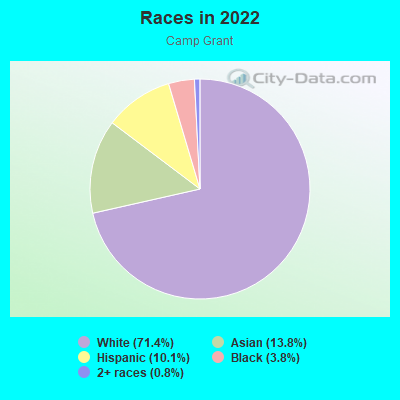
- 1,32571.4%White
- 25613.8%Asian
- 18810.1%Hispanic or Latino
- 713.8%Black
- 150.8%Two or more races
Median household income in 2022:
| Camp Grant: | $72,289 |
| Rockford: | $53,994 |
Distribution of median household income
![Distribution of median household income]()
- 5Less than $10,000
- 40$10,000 to $19,999
- 39$20,000 to $29,999
- 40$30,000 to $39,999
- 14$40,000 to $49,999
- 34$50,000 to $59,999
- 110$60,000 to $74,999
- 126$75,000 to $99,999
- 133$100,000 to $124,999
- 79$125,000 to $149,999
- 119$150,000 to $199,999
- 5$200,000 or more

Distribution of owner-occupied house/condo value
![Distribution of owner-occupied house/condo value]()
- 50Less than $50,000
- 64$50,000 to $99,999
- 172$100,000 to $149,999
- 294$150,000 to $199,999
- 154$200,000 to $249,999
- 95$250,000 to $299,999
- 5$300,000 to $399,999
- 5$400,000 to $499,999
- 2$500,000 to $749,999
- 39$1,000,000 or more

Distribution of rent paid by renters
![Distribution of rent paid by renters]()
- 26$200 to $299
- 2$400 to $499
- 4$500 to $599
- 13$600 to $699
- 136$700 to $799
- 1$800 to $899
- 2$900 to $999
- 110$1,000 to $1,249
- 20$1,250 to $1,499
- 1$1,500 to $1,999

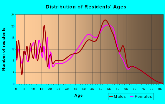
| Males: | 819 |
| Females: | 837 |
Males:
| This neighborhood: | 47.5 years |
| Whole city: | 35.2 years |
| This neighborhood: | 48.8 years |
| Whole city: | 39.3 years |
Average household size:
| Camp Grant: | 2.4 people |
| Rockford: | 2.4 people |
Percentage of family households:
| Camp Grant: | 37.6% |
| Rockford: | 39.3% |
| Here: | 56.9% |
| Rockford: | 36.1% |
Percentage of married-couple families with children (among all households):
| Camp Grant: | 33.6% |
| Rockford: | 19.8% |
Percentage of single-mother households (among all households):
| Camp Grant: | 6.9% |
| Rockford: | 16.9% |
Percentage of never married males 15 years old and over:
Percentage of never married females 15 years old and over:
| Camp Grant: | 13.5% |
| Rockford: | 20.2% |
Percentage of never married females 15 years old and over:
| Camp Grant: | 3.4% |
| city: | 19.9% |
Percentage of people that speak English not well or not at all:
| Camp Grant: | 0.8% |
| Rockford: | 2.9% |
Percentage of people born in this state:
Percentage of people born in another U.S. state:
Percentage of native residents but born outside the U.S.:
Percentage of foreign born residents:
| Here: | 70.9% |
| Rockford: | 70.1% |
Percentage of people born in another U.S. state:
| Camp Grant: | 19.9% |
| Rockford: | 17.3% |
Percentage of native residents but born outside the U.S.:
| Here: | 0.6% |
| city: | 2.2% |
Percentage of foreign born residents:
| Here: | 8.6% |
| Rockford: | 10.4% |
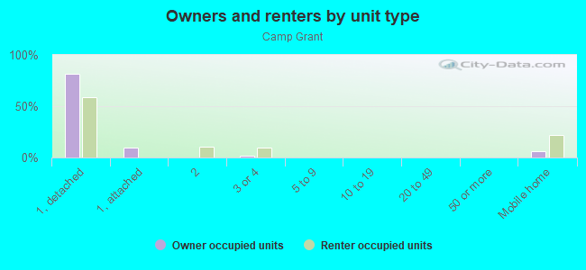
Owner-occupied
Renter-occupied

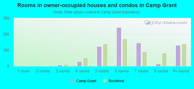
- Rooms in owner-occupied houses and condos in Camp Grant
- 01 room
- 02 rooms
- 93 rooms
- 294 rooms
- 1255 rooms
- 2426 rooms
- 1467 rooms
- 148 rooms
- 1329+ rooms
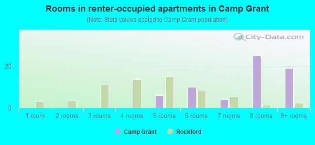
- Rooms in renter-occupied apartments in Camp Grant
- 01 room
- 02 rooms
- 03 rooms
- 04 rooms
- 65 rooms
- 106 rooms
- 47 rooms
- 258 rooms
- 199+ rooms
Owner-occupied
Renter-occupied
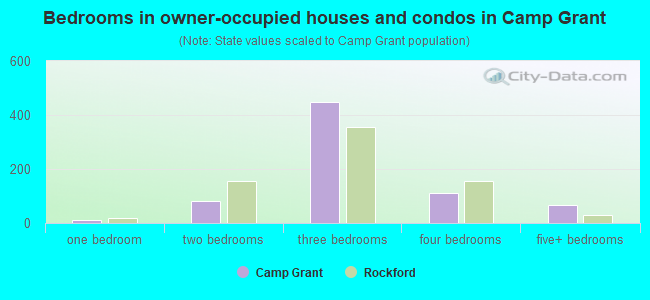
- Bedrooms in owner-occupied houses and condos in Camp Grant
- 0no bedroom
- 121 bedroom
- 822 bedrooms
- 4493 bedrooms
- 1104 bedrooms
- 665+ bedrooms
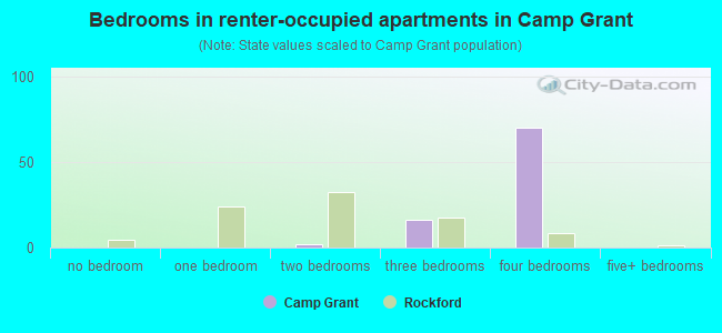
- Bedrooms in renter-occupied apartments in Camp Grant
- 0no bedroom
- 01 bedroom
- 22 bedrooms
- 163 bedrooms
- 704 bedrooms
- 05+ bedrooms
Average number of cars or other vehicles available in houses/condos:
Average number of cars or other vehicles available in apartments:
| This neighborhood: | 1.7 |
| Rockford: | 1.9 |
Average number of cars or other vehicles available in apartments:
| Here: | |
| city: |
Percentage of units with a mortgage:
| Camp Grant: | 58.0% |
| Rockford: | 63.1% |
Average estimated value of detached houses in 2022 (93.5% of all units):
| Camp Grant: | $158,886 |
| Illinois: | $310,164 |
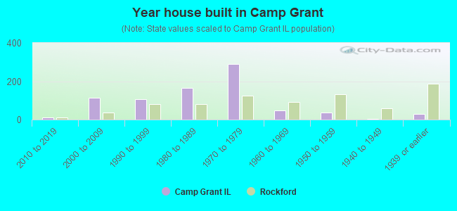
- Year house built in Camp Grant
- 02020 or later
- 102010 to 2019
- 1122000 to 2009
- 1061990 to 1999
- 1661980 to 1989
- 2901970 to 1979
- 471960 to 1969
- 351950 to 1959
- 41940 to 1949
- 291939 or earlier
City-data.com crime index for city in 2020 (higher means more crime):
| City: | 525.8 |
| U.S. average: | 219.5 |
Travel time to work (commute)
![Travel time to work (commute)]()
- 17Less than 5 minutes
- 905 to 9 minutes
- 12910 to 14 minutes
- 16215 to 19 minutes
- 12220 to 24 minutes
- 2625 to 29 minutes
- 3930 to 34 minutes
- 1735 to 39 minutes
- 3140 to 44 minutes
- 10045 to 59 minutes
- 1360 to 89 minutes
- 790 or more minutes

Means of transportation to work
![Means of transportation to work]()
- 73.0%521Drove a car alone
- 14.4%103Carpooled
- 1.8%13Motorcycle
- 3.5%25Walked
- 0.1%1Other means
- 11.9%85Worked at home

Time leaving home to go to work
![Time leaving home to go to work]()
- 5912:00 a.m. to 4:59 a.m.
- 425:00 a.m. to 5:29 a.m.
- 305:30 a.m. to 5:59 a.m.
- 666:00 a.m. to 6:29 a.m.
- 686:30 a.m. to 6:59 a.m.
- 1097:00 a.m. to 7:29 a.m.
- 997:30 a.m. to 7:59 a.m.
- 588:00 a.m. to 8:29 a.m.
- 208:30 a.m. to 8:59 a.m.
- 149:00 a.m. to 9:59 a.m.
- 1210:00 a.m. to 10:59 a.m.
- 711:00 a.m. to 11:59 a.m.
- 4812:00 p.m. to 3:59 p.m.
- 504:00 p.m. to 11:59 p.m.

Occupations of males:
- Percentage of males in management occupations (except farmers):
Here: 9.9% city: 7.0%
- Percentage of males in business and financial operations occupations:
Here: 2.3% city: 2.3%
- Percentage of males in computer and mathematical occupations:
Here: 4.6% city: 2.7%
- Percentage of males in architecture and engineering occupations:
Here: 12.0% city: 3.2%
- Percentage of males in service occupations:
Here: 2.4% city: 12.6%
- Percentage of males in sales and office occupations:
Here: 8.2% city: 16.0%
- Percentage of males in farming, fishing, and forestry occupations:
Here: 2.4% city: 0.0%
- Percentage of males in production occupations:
Here: 19.8% city: 18.7%
- Percentage of males in transportation occupations:
Here: 27.5% city: 6.0%
- Percentage of males in material moving occupations:
Here: 2.7% city: 10.5%
Occupations of females:
- Percentage of females in management occupations (except farmers):
Here: 9.7% city: 6.2%
- Percentage of females in business and financial operations occupations:
Here: 4.9% city: 3.4%
- Percentage of females in community and social services occupations:
Here: 2.1% city: 2.0%
- Percentage of females in education, training, and library occupations:
Here: 13.3% city: 6.1%
- Percentage of females in arts, design, entertainment, sports, and media occupations:
Here: 4.1% city: 1.2%
- Percentage of females in healthcare practitioners and technical occupations:
Here: 2.9% city: 10.2%
- Percentage of females in service occupations:
Here: 22.5% city: 26.8%
- Percentage of females in sales and office occupations:
Here: 13.1% city: 25.9%
- Percentage of females in production occupations:
Here: 22.9% city: 7.5%
- Percentage of females in material moving occupations:
Here: 3.1% city: 4.8%
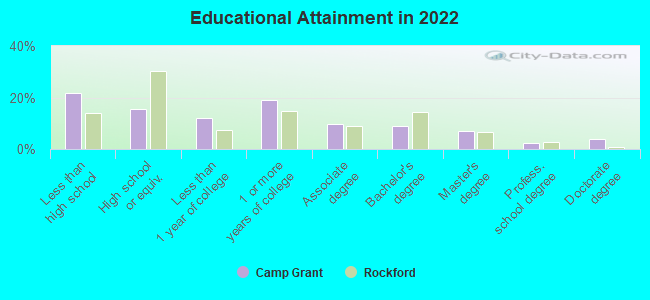
Education in this neighborhood (subdivision or community):
- Percentage of people 3 years and older in K-12 schools:
Camp Grant: 25.0% Rockford: 17.1%
- Percentage of people 3 years and older in undergraduate colleges:
Camp Grant: 5.0% Rockford: 3.4%
- Percentage of people 3 years and older in grad. or professional schools:
Camp Grant: 0.8% Rockford: 0.7%
- Percentage of students K-12 enrolled in private schools:
Camp Grant: 33.3% Rockford: 14.7%
Percentage of population below poverty level:
| Camp Grant: | 8.2% |
| Rockford: | 21.1% |
Median year owner moved in (as recorded in 2022):
| Camp Grant: | 2003 |
| Rockford: | 2010 |
Percentage of married-couple families with both working:
| Camp Grant: | 61.3% |
| Rockford: | 64.5% |
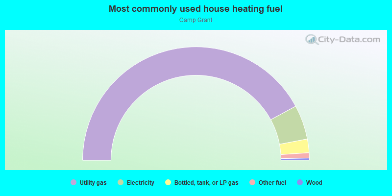
- 84.2%Utility gas
- 9.8%Electricity
- 3.9%Bottled, tank, or LP gas
- 1.5%Other fuel
- 0.6%Wood
Highways in this neighborhood:
State Rte 251 (11th St)
Length: 1.14 miles
Directions: E-W, N-S, SW-NE
Address range: 6000 to 7281
Directions: E-W, N-S, SW-NE
Address range: 6000 to 7281
Roads and streets:
Blackhawk Rd
Length: 1.67 miles
Directions: E-W, SE-NW
Address range: 2300 to 3501
Directions: E-W, SE-NW
Address range: 2300 to 3501
New Milford School Rd
Length: 1.27 miles
Directions: E-W, SW-NE
Address range: 2251 to 3199
Directions: E-W, SW-NE
Address range: 2251 to 3199
Halverson Dr
Length: 0.76 miles
Directions: E-W, N-S, SE-NW, SW-NE
Address range: 6000 to 6699
Directions: E-W, N-S, SE-NW, SW-NE
Address range: 6000 to 6699
Cherokee Hills Dr
Length: 0.70 miles
Directions: E-W, N-S, SW-NE
Address range: 6100 to 6499
Directions: E-W, N-S, SW-NE
Address range: 6100 to 6499
Falling Leaf Dr
Length: 0.68 miles
Directions: E-W, SW-NE
Address range: 3400 to 3999
Directions: E-W, SW-NE
Address range: 3400 to 3999
Valley Trail Rd
Length: 0.57 miles
Direction: N-S
Address range: 6006 to 6699
Direction: N-S
Address range: 6006 to 6699
Larry St
Length: 0.49 miles
Direction: E-W
Address range: 2400 to 2699
Direction: E-W
Address range: 2400 to 2699
Rydberg Rd
Length: 0.48 miles
Directions: E-W, N-S, SE-NW
Address range: 6700 to 7055
Directions: E-W, N-S, SE-NW
Address range: 6700 to 7055
Rockview Rd
Length: 0.48 miles
Directions: E-W, SE-NW
Address range: 3400 to 3999
Directions: E-W, SE-NW
Address range: 3400 to 3999
Thorncrest Dr
Length: 0.47 miles
Directions: N-S, SW-NE
Address range: 6000 to 6499
Directions: N-S, SW-NE
Address range: 6000 to 6499
Abraham Dr
Length: 0.45 miles
Directions: N-S, SE-NW
Address range: 6100 to 6499
Directions: N-S, SE-NW
Address range: 6100 to 6499
Penguin Dr
Length: 0.43 miles
Directions: N-S, SE-NW, SW-NE
Address range: 6088 to 6499
Directions: N-S, SE-NW, SW-NE
Address range: 6088 to 6499
Bristlecone Ln
Length: 0.43 miles
Directions: N-S, SE-NW, SW-NE
Address range: 6000 to 6509
Directions: N-S, SE-NW, SW-NE
Address range: 6000 to 6509
Ral Mar Rd
Length: 0.41 miles
Directions: E-W, N-S, SE-NW, SW-NE
Address range: 6150 to 6499
Directions: E-W, N-S, SE-NW, SW-NE
Address range: 6150 to 6499
Meadow Song Trl
Length: 0.39 miles
Directions: E-W, N-S, SE-NW, SW-NE
Address range: 6800 to 6916
Directions: E-W, N-S, SE-NW, SW-NE
Address range: 6800 to 6916
New Milford Church Rd
Length: 0.38 miles
Direction: E-W
Address range: 2252 to 6225
Direction: E-W
Address range: 2252 to 6225
20th St
Length: 0.35 miles
Direction: N-S
Address range: 6000 to 6349
Direction: N-S
Address range: 6000 to 6349
Calcutta Dr
Length: 0.32 miles
Directions: E-W, SE-NW
Address range: 3900 to 4299
Directions: E-W, SE-NW
Address range: 3900 to 4299
Capron Dr
Length: 0.31 miles
Direction: E-W
Address range: 3700 to 3999
Direction: E-W
Address range: 3700 to 3999
Lorilynn Ln
Length: 0.29 miles
Directions: E-W, N-S, SE-NW
Address range: 6000 to 6299
Directions: E-W, N-S, SE-NW
Address range: 6000 to 6299
Carlsburg Ln
Length: 0.29 miles
Directions: N-S, SE-NW, SW-NE
Address range: 6100 to 6399
Directions: N-S, SE-NW, SW-NE
Address range: 6100 to 6399
Carriage Trail Rd
Length: 0.28 miles
Direction: E-W
Address range: 3000 to 3199
Direction: E-W
Address range: 3000 to 3199
Wynbrook Dr
Length: 0.28 miles
Directions: E-W, N-S, SW-NE
Address range: 6100 to 6299
Directions: E-W, N-S, SW-NE
Address range: 6100 to 6299
Balboa St
Length: 0.25 miles
Direction: N-S
Address range: 6200 to 6499
Direction: N-S
Address range: 6200 to 6499
Far Hill Rd
Length: 0.25 miles
Directions: E-W, N-S, SW-NE
Address range: 3033 to 3168
Directions: E-W, N-S, SW-NE
Address range: 3033 to 3168
Sheffield Dr
Length: 0.23 miles
Directions: E-W, SW-NE
Address range: 6499 to 6599
Directions: E-W, SW-NE
Address range: 6499 to 6599
Dana Dr
Length: 0.23 miles
Directions: N-S, SE-NW, SW-NE
Address range: 2900 to 6198
Directions: N-S, SE-NW, SW-NE
Address range: 2900 to 6198
Rydberg Ct
Length: 0.21 miles
Direction: E-W
Address range: 6700 to 6799
Direction: E-W
Address range: 6700 to 6799
Chick-Charney Dr
Length: 0.20 miles
Direction: E-W
Address range: 3300 to 3449
Direction: E-W
Address range: 3300 to 3449
Conner Ln
Length: 0.19 miles
Directions: N-S, SE-NW
Address range: 6045 to 6239
Directions: N-S, SE-NW
Address range: 6045 to 6239
Alamo Dr
Length: 0.18 miles
Directions: N-S, SE-NW
Address range: 6000 to 6199
Directions: N-S, SE-NW
Address range: 6000 to 6199
Billie Rd
Length: 0.18 miles
Directions: E-W, SE-NW
Address range: 2900 to 2999
Directions: E-W, SE-NW
Address range: 2900 to 2999
Old Chapel Rd
Length: 0.17 miles
Directions: E-W, SW-NE
Address range: 3000 to 3199
Directions: E-W, SW-NE
Address range: 3000 to 3199
Quiet Valley Ln
Length: 0.17 miles
Directions: E-W, SW-NE
Address range: 3300 to 3429
Directions: E-W, SW-NE
Address range: 3300 to 3429
Mallard Dr
Length: 0.17 miles
Directions: E-W, SE-NW, SW-NE
Address range: 4100 to 4199
Directions: E-W, SE-NW, SW-NE
Address range: 4100 to 4199
Bonnie Dr
Length: 0.15 miles
Directions: E-W, N-S, SW-NE
Address range: 2300 to 2399
Directions: E-W, N-S, SW-NE
Address range: 2300 to 2399
Sioux Ct
Length: 0.15 miles
Directions: E-W, N-S, SW-NE
Address range: 2500 to 2699
Directions: E-W, N-S, SW-NE
Address range: 2500 to 2699
Groveland Rd
Length: 0.14 miles
Direction: E-W
Address range: 3800 to 3899
Direction: E-W
Address range: 3800 to 3899
Hidden Trail Rd
Length: 0.13 miles
Direction: E-W
Address range: 3200 to 3299
Direction: E-W
Address range: 3200 to 3299
Empress Ln
Length: 0.13 miles
Direction: N-S
Address range: 6200 to 6399
Direction: N-S
Address range: 6200 to 6399
Lockwood Dr
Length: 0.13 miles
Direction: N-S
Address range: 6034 to 6199
Direction: N-S
Address range: 6034 to 6199
Field Stone Dr
Length: 0.12 miles
Directions: N-S, SE-NW
Address range: 6300 to 6499
Directions: N-S, SE-NW
Address range: 6300 to 6499
Penguin Cir
Length: 0.11 miles
Directions: N-S, SE-NW, SW-NE
Address range: 6500 to 6599
Directions: N-S, SE-NW, SW-NE
Address range: 6500 to 6599
Winchester Dr
Length: 0.09 miles
Direction: N-S
Address range: 6200 to 6399
Direction: N-S
Address range: 6200 to 6399
Claudana Dr
Length: 0.08 miles
Directions: E-W, SW-NE
Address range: 2900 to 2999
Directions: E-W, SW-NE
Address range: 2900 to 2999
Abraham Cir
Length: 0.07 miles
Direction: E-W
Address range: 6301 to 6399
Direction: E-W
Address range: 6301 to 6399
Essex Cir
Length: 0.07 miles
Directions: E-W, SW-NE
Address range: 6201 to 6299
Directions: E-W, SW-NE
Address range: 6201 to 6299
Lorraine Ln
Length: 0.07 miles
Directions: E-W, SW-NE
Address range: 2400 to 2499
Directions: E-W, SW-NE
Address range: 2400 to 2499
Livingstone Ct
Length: 0.05 miles
Direction: N-S
Address range: 6500 to 6599
Direction: N-S
Address range: 6500 to 6599
Halverson Ct
Length: 0.04 miles
Directions: N-S, SW-NE
Address range: 3300 to 3399
Directions: N-S, SW-NE
Address range: 3300 to 3399
Carlesburg Ct
Length: 0.04 miles
Direction: E-W
Address range: 3500 to 3599
Direction: E-W
Address range: 3500 to 3599
New Milford Church Ct
Length: 0.02 miles
Direction: N-S
Address range: 6221 to 6227
Direction: N-S
Address range: 6221 to 6227
S Bend Rd
Length: 0.01 miles
Direction: E-W
Address range: 2294 to 2299
Direction: E-W
Address range: 2294 to 2299