Not sure how official this list is but I thought it was the best extensive detailed list I saw.
EverythingWx | November 17, 2013 Tornado and Severe Thunderstorm Outbreak
List of confirmed tornadoes via the NWS (will be updated once storm surveys are completed):
ILLINOIS (12 confirmed tornadoes)
*An
EF-4 tornado touched down in northern
Washington County near New Minden with maximum estimated winds of at least 166 mph. The maximum width was 200 yards and it traveled 10.6 miles. There were
2 fatalities from this tornado along with
2 injuries.
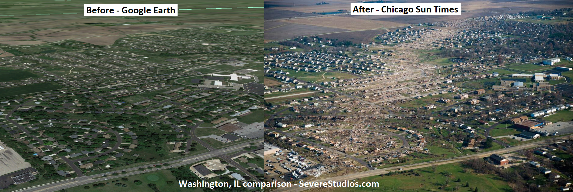
*An
EF-4 tornado struck
Washington, IL with maximum estimated winds of around 190 mph. This tornado affected portions of Tazwell, Woodfard, La Salle, and Livingston counties. The maximum width was 0.5 mile and it traveled 46.2 miles. There was
1 fatality from this tornado along with
122 injuries.
*An
EF-3 tornado touched down just west of
Brookport, IL (Massac and Pope counties) with estimated maximum winds of 145 mph. The maximum width was 500 yards and it more than traveled 11.5 miles. There were
3 fatalities associated with this tornado and more than 13 others were injured. **This tornado continued into KY and this information will be updated as it becomes available**
*An
EF-3 tornado touched down near
Gifford with estimated maximum winds of 140 mph. The maximum width was 0.25 mile and it traveled 24 miles. There were no fatalities and
6 minor injuries associated with this tornado.
*An
EF-2 tornado touched down near
Manhattan and Frankfort with estimated maximum winds of 125 mph. The maximum width was 200 yards and it traveled 5.5 miles.
*An
EF-2 tornado affected
Grundy and southwest Will counties (Coal city) with estimated maximum winds of 122 mph. The maximum width was 200 yards and it traveled 12.9 miles.
*An
EF-2 tornado touched down near
Pekin with estimated maximum winds of 120 mph. The maximum width was 100 yards and it traveled 2.5 miles. There were no fatalities and
10 injuries associated with this tornado.
*An
EF-2 tornado touched down near
St. Elmo with estimated maximum winds of 120 mph. The maximum width was 200 yards and it traveled 11.5 miles. There were no fatalities or injuries associated with this tornado.
*An
EF-1 tornado touched down near
Hoyleton and lifted near Centralia. The tornado had estimated maximum winds of 95-100 mph. The maximum width was 50-100 yards and the tornado traveled for 4.9 miles. There were no fatalities or injures from this tornado.
*An
EF-1 tornado touched down near
Breese with estimated maximum winds of 100 mph. The maximum width was 50 yards and it traveled 0.4 miles. There were no fatalities or injuries associated with this tornado.
*An
EF-0 tornado touched down near
Wellington, IL (Iroquois County) with estimated maximum winds of 80 mph. The maximum width was 75 yards and it traveled 4.6 miles.
*A
tornado touched down in
Douglas county.
INDIANA (22 confirmed tornadoes)
*An
EF-3 tornado touched down S/SE of
Lafayette and lifted just west of Dayton.
*An
EF-2 tornado touched down in
Kosciusko County with estimated maximum winds of 125 mph. The maximum path width was 150 yards and it traveled 4 miles.
*An
EF-2 tornado affected
western Grant County with a path length of 12 miles and a maximum width of 0.4 miles.
*An
EF-2 tornado affected the
Kokomo area and traveled approximately 10 miles.
*An
EF-2 tornado affected the
Kokomo area (a second tornado in the same general area) with a relatively short path length.
*An
EF-2 tornado touched down near
Lebanon with estimated maximum winds of 115 mph. The maximum width was 75 yards and it traveled 3.5 miles.
*An
EF-2 tornado touched down
near Maysville and traveled for 2.75 miles. The maximum width was 130 yards.
*An
EF-2 tornado touched down in
southwest Knox County and traveled for 19.4 miles. The maximum width was 100 yards.
*An
EF-1 tornado touched down in
Miami County with estimated maximum winds of 110 mph. The maximum path width was 75 yards and it traveled 1.8 miles.
*An
EF-1 tornado touched down near
Renesselaer in Jasper County and continued into Pulaski County with estimated maximum winds of 110 mph.The maximum width was 100 yards and the tornado traveled for 24.5 miles.
*An
EF-1 tornado touched down in
Atlanta (Hamilton County) with estimated maximum winds of 100 mph. The maximum path width was 150 yards and it traveled 1.9 miles.
*An
EF-1 tornado touched down approximately
7 miles northeast of Lebanon with estimated maximum winds of 100 mph. The maximum path width was 75 yards and it traveled 0.6 miles.
*An
EF-1 tornado touched down in
White county with estimated maximum winds of 90 mph. The maximum path width was 75 yards and it traveled 0.6 miles.
*An
EF-1 tornado touched down
north of Bedford with estimated maximum winds of 90 mph.
*An
EF-1 tornado touched down in
Goodland (Newton County) with estimated maximum winds of 110 mph. The maximum width was 100 yards and it traveled 5.6 miles.
*An
EF-1 tornado affected
southeast Benton County with estimated maximum winds of 95 mph. The maximum width was 100 yards and it traveled 2.9 miles (not including the path in the Northern Indiana WFO).
*An
EF-0 tornado touched down in
Cass county with estimated maximum winds of 80 mph. The maximum path width was 100 yards and it traveled 0.9 miles.
*An
EF-0 tornado touched down in
Cass county with estimated maximum winds of 80 mph. The maximum path width was 200 yards and it traveled 1.6 miles.
*An
EF-0 tornado affected
central Grant county near Roseburg with a brief touchdown.
*An
EF-0 tornado touched down just east of
Russiaville.
*A
tornado touched down from Rileysburg to West of Covington (Northern Vermillion/Southern Warren counties). The intensity has yet to be determined.
*
Tornado from Mellott to State Route 25 near the Montgomery-Tippecanoe County border.
**Survey incomplete, will continue on Tuesday.**
KENTUCKY (2 confirmed tornadoes)
*An
EF-3 tornado touched down
near Morganfield (Union and Henderson counties) with estimated maximum winds of 145 mph. The maximum width was 200 yards and it more than traveled 14.5 miles. There were no fatalities or injuries associated with this tornado.
An
EF-1 tornado touched down
near Huntsville with estimated maximum winds of 105 mph. The maximum width was 200 yards and it traveled for 5.3 miles. There were no fatalities and
1 injury associated with this tornado.
TENNESSEE (3 confirmed tornadoes)
*An
EF-1 tornado touched down
near Orlinda with estimated maximum winds of 90 mph. The maximum width was 100 yards and it traveled for 1 mile.
*An
EF-0 tornado touched down
near Howell with estimated maximum winds of 85 mph. The maximum width was 25 yards and it traveled for 0.6 miles.
*An
EF-0 tornado touched down
near Portland with estimated maximum winds of 70 mph. The maximum width was 50 yards and it traveled for 0.5 mile.
OHIO (5 confirmed tornadoes)
*An
EF-2 tornado touched down in
Paulding and Putnam counties with estimated maximum winds of 130 mph. The maximum path width was 440 yards and it traveled 8 miles.
*An
EF-2 tornado affected
Wood and Lucas counties with estimated maximum winds of 120-125 mph. The maximum width was 150-200 yards and it traveled approximately 12 miles.
*An
EF-1 tornado affected
central Wood county with estimated maximum winds of 105-110 mph. The maximum width was 75-100 yards and it traveled approximately 1 mile.
*An
EF-1 tornado touched down in
Van Wert county with estimated maximum winds of 100 mph. The maximum path width was 150 yards and it traveled approximately 2 miles.
*A
tornado touched down briefly
near Elmore in Ottawa County.
MICHIGAN (3 confirmed tornadoes)
*An
EF-1 tornado touched down in
Cass county with estimated maximum winds of 110 mph. The maximum width was 50 yards and it traveled for just under 0.5 mile.
*An
EF-0 tornado touched down in extreme
southern Otsego county with estimated maximum winds of 65-75 mph. The maximum width was 150 yards and it traveled 0.3 miles.
*An
EF-0 tornado affected extreme
eastern Muskegon and southern Newaygo counties with estimated maximum winds of 75 mph. The maximum width was less than 100 yards and it traveled on an intermittent path for 50 miles.

 Please register to participate in our discussions with 2 million other members - it's free and quick! Some forums can only be seen by registered members. After you create your account, you'll be able to customize options and access all our 15,000 new posts/day with fewer ads.