Westside, California
Submit your own pictures of this place and show them to the world
- OSM Map
- General Map
- Google Map
- MSN Map

| Males: 17,912 | |
| Females: 14,472 |
| Median resident age: | 34.8 years |
| California median age: | 33.3 years |
Zip code: 93268
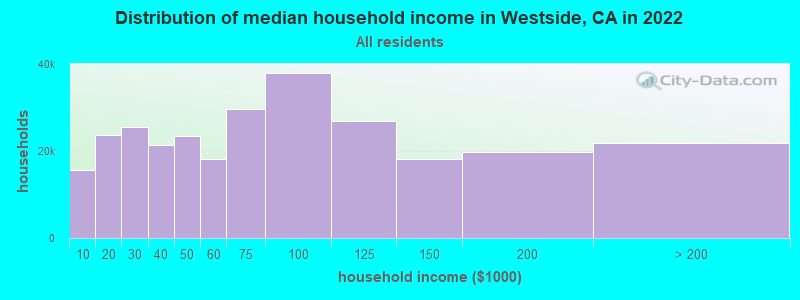
| Westside: | $65,855 |
| CA: | $91,551 |
Estimated per capita income in 2022: $30,243 (it was $16,685 in 2000)
Westside CCD income, earnings, and wages data
Estimated median house or condo value in 2022: $293,087 (it was $79,400 in 2000)
| Westside: | $293,087 |
| CA: | $715,900 |
Mean prices in 2022: all housing units: $366,187; detached houses: $384,471; townhouses or other attached units: $303,616; in 2-unit structures: $562,075; in 3-to-4-unit structures: $224,286; in 5-or-more-unit structures: $262,914; mobile homes: $180,289; occupied boats, rvs, vans, etc.: $173,886
Detailed information about poverty and poor residents in Westside, CA


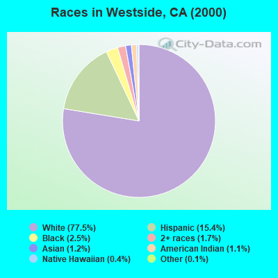
- 21,22677.5%White alone
- 4,22915.4%Hispanic
- 6982.5%Black alone
- 4721.7%Two or more races
- 3251.2%Asian alone
- 2981.1%American Indian alone
- 990.4%Native Hawaiian and Other
Pacific Islander alone - 350.1%Other race alone
 Recent articles from our blog. Our writers, many of them Ph.D. graduates or candidates, create easy-to-read articles on a wide variety of topics.
Current Local Time: PST time zone
Elevation: 248 feet
Land area: 1149.4 square miles.
Population density: 28 people per square mile (very low).

| Westside CCD: | 1.0% ($770) |
| California: | 0.8% ($1,564) |
Nearest city with pop. 50,000+: Bakersfield, CA  (24.8 miles , pop. 247,057).
Nearest city with pop. 1,000,000+: Los Angeles, CA (89.1 miles , pop. 3,694,820).
Nearest cities:
), ), ), ), Latitude: 35.10 N, Longitude: 119.34 W
Area code commonly used in this area: 661

| Here: | 8.7% |
| California: | 5.1% |
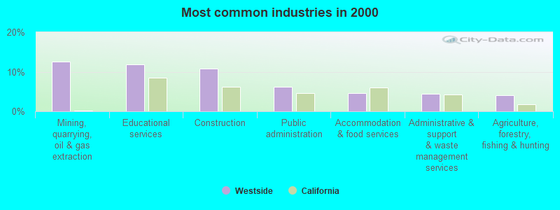
- Mining, quarrying, oil & gas extraction (12.6%)
- Educational services (11.9%)
- Construction (10.8%)
- Public administration (6.1%)
- Accommodation & food services (4.7%)
- Administrative & support & waste management services (4.4%)
- Agriculture, forestry, fishing & hunting (4.0%)
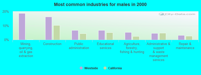
- Mining, quarrying, oil & gas extraction (18.7%)
- Construction (16.2%)
- Public administration (6.8%)
- Educational services (6.7%)
- Agriculture, forestry, fishing & hunting (5.3%)
- Administrative & support & waste management services (4.6%)
- Repair & maintenance (3.3%)
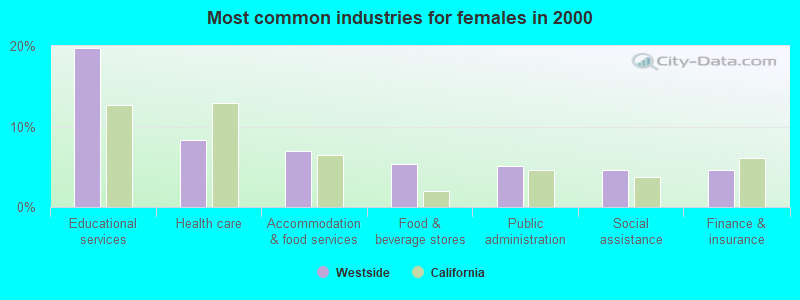
- Educational services (19.8%)
- Health care (8.3%)
- Accommodation & food services (6.9%)
- Food & beverage stores (5.4%)
- Public administration (5.1%)
- Social assistance (4.7%)
- Finance & insurance (4.5%)
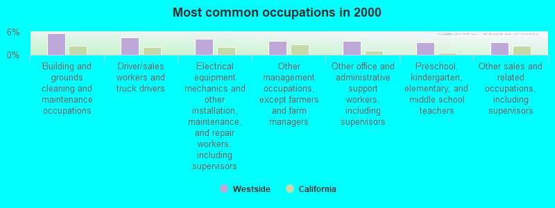
- Building and grounds cleaning and maintenance occupations (5.7%)
- Driver/sales workers and truck drivers (4.5%)
- Electrical equipment mechanics and other installation, maintenance, and repair workers, including supervisors (4.2%)
- Other management occupations, except farmers and farm managers (3.6%)
- Other office and administrative support workers, including supervisors (3.5%)
- Preschool, kindergarten, elementary, and middle school teachers (3.3%)
- Other sales and related occupations, including supervisors (3.2%)
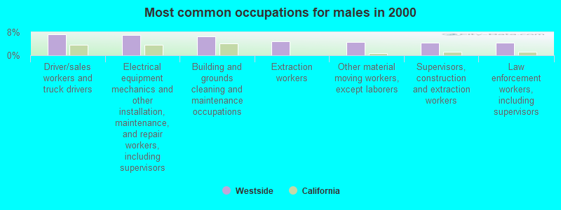
- Driver/sales workers and truck drivers (7.2%)
- Electrical equipment mechanics and other installation, maintenance, and repair workers, including supervisors (7.1%)
- Building and grounds cleaning and maintenance occupations (6.6%)
- Extraction workers (4.8%)
- Other material moving workers, except laborers (4.6%)
- Supervisors, construction and extraction workers (4.4%)
- Law enforcement workers, including supervisors (4.3%)
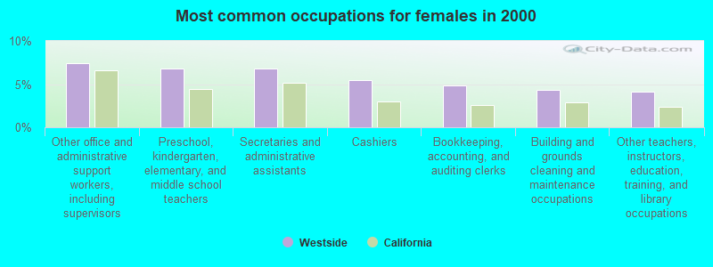
- Other office and administrative support workers, including supervisors (7.4%)
- Preschool, kindergarten, elementary, and middle school teachers (6.8%)
- Secretaries and administrative assistants (6.8%)
- Cashiers (5.4%)
- Bookkeeping, accounting, and auditing clerks (4.9%)
- Building and grounds cleaning and maintenance occupations (4.3%)
- Other teachers, instructors, education, training, and library occupations (4.1%)
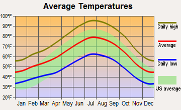
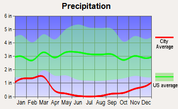
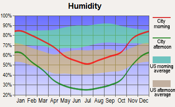
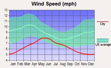
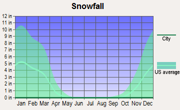
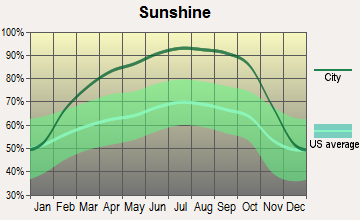
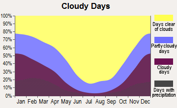
Average climate in Westside, California
Based on data reported by over 4,000 weather stations
(lower is better)
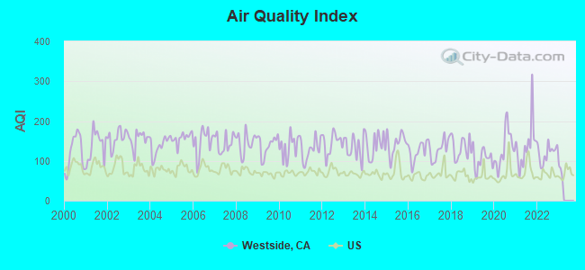
Air Quality Index (AQI) level in 2022 was 120. This is significantly worse than average.
| City: | 120 |
| U.S.: | 73 |
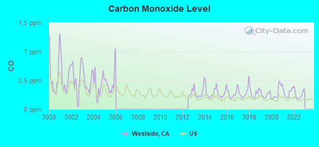
Carbon Monoxide (CO) [ppm] level in 2022 was 0.259. This is about average. Closest monitor was 21.4 miles away from the city center.
| City: | 0.259 |
| U.S.: | 0.251 |
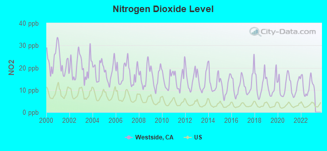
Nitrogen Dioxide (NO2) [ppb] level in 2022 was 11.8. This is significantly worse than average. Closest monitor was 21.4 miles away from the city center.
| City: | 11.8 |
| U.S.: | 5.1 |
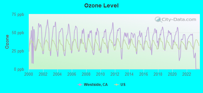
Ozone [ppb] level in 2022 was 40.9. This is worse than average. Closest monitor was 5.0 miles away from the city center.
| City: | 40.9 |
| U.S.: | 33.3 |
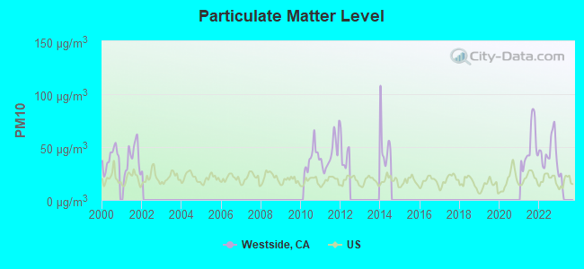
Particulate Matter (PM10) [µg/m3] level in 2022 was 46.2. This is significantly worse than average. Closest monitor was 7.4 miles away from the city center.
| City: | 46.2 |
| U.S.: | 19.2 |
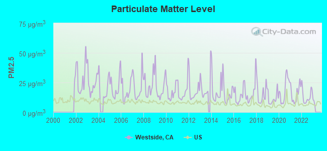
Particulate Matter (PM2.5) [µg/m3] level in 2022 was 13.5. This is significantly worse than average. Closest monitor was 23.6 miles away from the city center.
| City: | 13.5 |
| U.S.: | 8.1 |
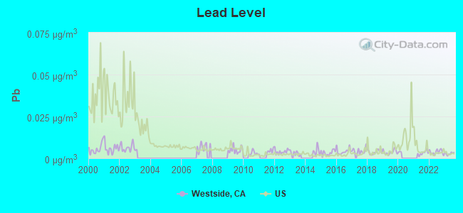
Lead (Pb) [µg/m3] level in 2023 was 0.00287. This is significantly better than average. Closest monitor was 7.7 miles away from the city center.
| City: | 0.00287 |
| U.S.: | 0.00931 |
Earthquake activity:
Westside-area historical earthquake activity is significantly above California state average. It is 7434% greater than the overall U.S. average.On 7/21/1952 at 11:52:14, a magnitude 7.7 (7.7 UK, Class: Major, Intensity: VIII - XII) earthquake occurred 20.5 miles away from the city center, causing $50,000,000 total damage
On 11/4/1927 at 13:51:53, a magnitude 7.5 (7.5 UK) earthquake occurred 96.7 miles away from the city center
On 6/28/1992 at 11:57:34, a magnitude 7.6 (6.2 MB, 7.6 MS, 7.3 MW, Depth: 0.7 mi) earthquake occurred 171.9 miles away from Westside center, causing 3 deaths (1 shaking deaths, 2 other deaths) and 400 injuries, causing $100,000,000 total damage and $40,000,000 insured losses
On 4/18/1906 at 13:12:21, a magnitude 7.9 (7.9 UK) earthquake occurred 285.5 miles away from the city center, causing $524,000,000 total damage
On 10/16/1999 at 09:46:44, a magnitude 7.4 (6.3 MB, 7.4 MS, 7.2 MW, 7.3 ML) earthquake occurred 169.9 miles away from Westside center
On 1/17/1994 at 12:30:55, a magnitude 6.8 (6.4 MB, 6.8 MS, 6.7 MW, Depth: 11.4 mi, Class: Strong, Intensity: VII - IX) earthquake occurred 78.5 miles away from Westside center, causing 60 deaths (60 shaking deaths) and 7000 injuries
Magnitude types: body-wave magnitude (MB), local magnitude (ML), surface-wave magnitude (MS), moment magnitude (MW)
Natural disasters:
The number of natural disasters in Kern County (29) is a lot greater than the US average (15).Major Disasters (Presidential) Declared: 14
Emergencies Declared: 3
Causes of natural disasters: Fires: 12, Floods: 12, Storms: 7, Winter Storms: 5, Mudslides: 4, Landslides: 3, Freezes: 2, Drought: 1, Heavy Rain: 1, Hurricane: 1, Snow: 1, Tornado: 1, Wind: 1, Other: 1 (Note: some incidents may be assigned to more than one category).
Colleges/universities with over 2000 students nearest to Westside:
- Taft College (about 8 miles; Taft, CA; Full-time enrollment: 2,121)
- California State University-Bakersfield (about 22 miles; Bakersfield, CA; FT enrollment: 7,564)
- Bakersfield College (about 30 miles; Bakersfield, CA; FT enrollment: 10,325)
- Santa Barbara City College (about 53 miles; Santa Barbara, CA; FT enrollment: 12,568)
- University of California-Santa Barbara (about 56 miles; Santa Barbara, CA; FT enrollment: 22,806)
- Ventura College (about 58 miles; Ventura, CA; FT enrollment: 8,460)
- Allan Hancock College (about 63 miles; Santa Maria, CA; FT enrollment: 6,639)
Points of interest:
Notable locations in Westside: A M Cooper Ranch (A), Lakeview Labor Camp (B), Lease Camp (C), Levee Spur (D), Harris Ranch (E), Midway Oil Camp (F), San Emigdio Girl Scout Camp (G), San Emidio Ranch (H), Richfield Oil Pumping Station (I), Cooper Ranch (J), Southern Calif Gas Camp (K), Standard Oil Signa Station (L), Temblor Ranch (M), Western Water Country Camp (N), Tupman Camp (O), Thirty Five-R Gas Plant (P), Symons Ranch (Q), Taft City Corporation Yard (R), Honolulu Oil Main Camp (S), Petroleum Club (T). Display/hide their locations on the map
Shopping Centers: Westside Shopping Center (1), Taft Hills Plaza Shopping Center (2), Hall Mart Shopping Center (3). Display/hide their locations on the map
Churches in Westside include: Community Christian Fellowship Church (A), Assembly of God Church (B), Church of Christ (C), Church of God (D), The Church of Jesus Christ of Latter Day Saints (E), First Assembly of God Church (F), First Baptist Church (G), First Church of Christ Scientist (H), First Presbyterian Church (I). Display/hide their locations on the map
Cemetery: Westside District Cemetery (1). Display/hide its location on the map
Lakes: Lake Webb (A), Lake Evans (B), Connecting Slough (C). Display/hide their locations on the map
Creeks: Muddy Creek (A), Los Lobos Creek (B), Carneros Creek (C), Broad Creek (D), Temblor Creek (E), Bitter Creek (F), Bitterwater Creek (G), Cienaga Creek (H), Colorful Creek (I). Display/hide their locations on the map
Parks in Westside include: Rose Stage Station Historical Marker (1), Buena Vista Aquatic Recreational Area (2), Fort Tejon State Historic Park (3), Buena Vista Park (4), Capitola Park (5), Fages-Zalvidea Trails Marker (6), Franklin Field (7), Bitter Creek National Wildlife Refuge (8), Westside Mountain Park (9). Display/hide their locations on the map
| This place: | 2.7 people |
| California: | 2.9 people |
| This place: | 49.3% |
| Whole state: | 69.4% |
| This place: | 6.7% |
| Whole state: | 5.9% |
Likely homosexual households (counted as self-reported same-sex unmarried-partner households)
- Lesbian couples: 0.3% of all households
- Gay men: 0.3% of all households
| This place: | 19.0% |
| Whole state: | 14.2% |
| This place: | 9.0% |
| Whole state: | 6.3% |
People in group quarters in Westside in 2000:
- 2,411 people in local jails and other confinement facilities (including police lockups)
- 419 people in state prisons
- 63 people in college dormitories (includes college quarters off campus)
- 54 people in nursing homes
- 29 people in orthopedic wards and institutions for the physically handicapped
- 26 people in agriculture workers' dormitories on farms
- 25 people in other nonhousehold living situations
For population 15 years and over in Westside:
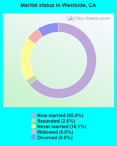
- Never married: 19.1%
- Now married: 65.4%
- Separated: 2.6%
- Widowed: 6.0%
- Divorced: 9.5%
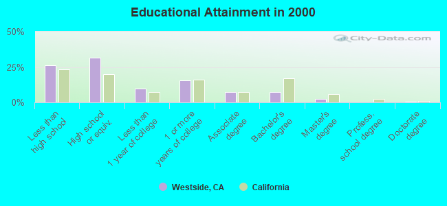
For population 25 years and over in Westside:
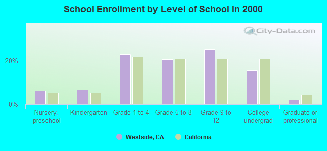
- High school or higher: 74.0%
- Bachelor's degree or higher: 10.0%
- Graduate or professional degree: 3.0%
- Unemployed: 11.3%
- Mean travel time to work (commute): 24.8 minutes
| Here: | 11.4 |
| California average: | 16.1 |
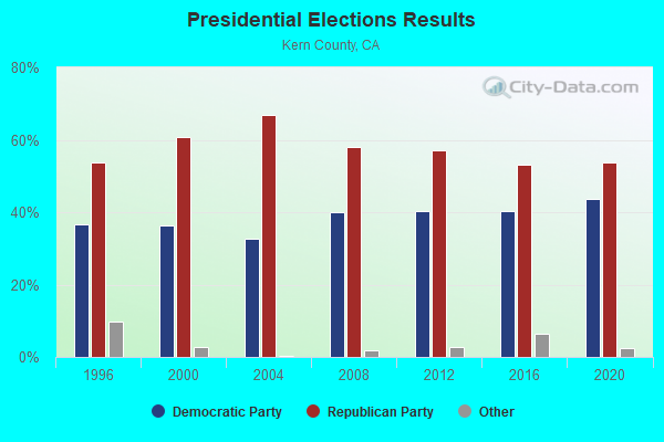
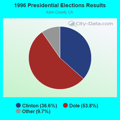
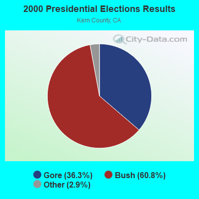
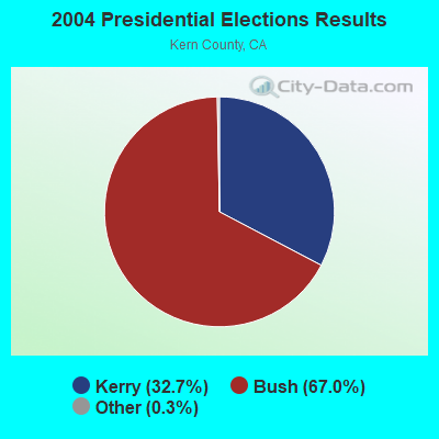
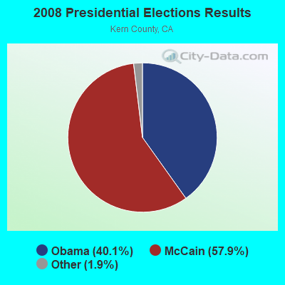
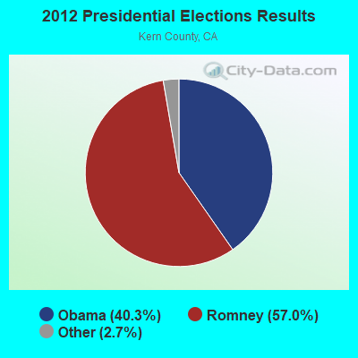
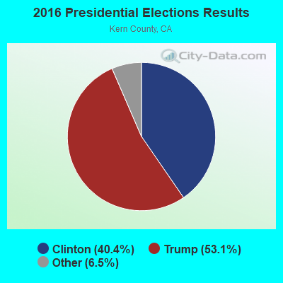
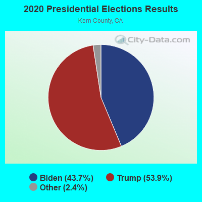
Graphs represent county-level data. Detailed 2008 Election Results
Religion statistics for Westside, CA (based on Kern County data)
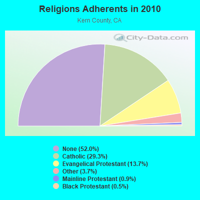
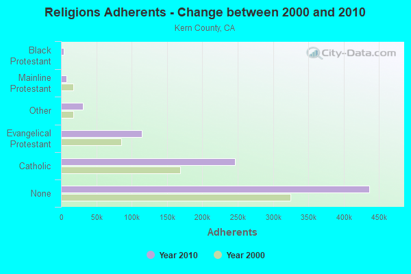
| Religion | Adherents | Congregations |
|---|---|---|
| Catholic | 245,836 | 30 |
| Evangelical Protestant | 114,724 | 436 |
| Other | 30,687 | 83 |
| Mainline Protestant | 7,459 | 38 |
| Black Protestant | 4,026 | 25 |
| Orthodox | 450 | 3 |
| None | 436,449 | - |
Food Environment Statistics:
| Here: | 2.41 / 10,000 pop. |
| State: | 2.14 / 10,000 pop. |
| Kern County: | 0.04 / 10,000 pop. |
| California: | 0.04 / 10,000 pop. |
| Kern County: | 0.80 / 10,000 pop. |
| California: | 0.62 / 10,000 pop. |
| Here: | 2.10 / 10,000 pop. |
| California: | 1.49 / 10,000 pop. |
| This county: | 4.60 / 10,000 pop. |
| California: | 7.42 / 10,000 pop. |
| Kern County: | 8.0% |
| State: | 7.3% |
| This county: | 29.4% |
| State: | 21.3% |
| Kern County: | 15.9% |
| State: | 17.9% |
4.83% of this county's 2021 resident taxpayers lived in other counties in 2020 ($47,246 average adjusted gross income)
| Here: | 4.83% |
| California average: | 5.19% |
0.03% of residents moved from foreign countries ($334 average AGI)
Kern County: 0.03% California average: 0.03%
Top counties from which taxpayers relocated into this county between 2020 and 2021:
| from Los Angeles County, CA | |
| from San Bernardino County, CA | |
| from Tulare County, CA |
4.56% of this county's 2020 resident taxpayers moved to other counties in 2021 ($61,654 average adjusted gross income)
| Here: | 4.56% |
| California average: | 6.14% |
0.03% of residents moved to foreign countries ($342 average AGI)
Kern County: 0.03% California average: 0.02%
Top counties to which taxpayers relocated from this county between 2020 and 2021:
| to Los Angeles County, CA | |
| to Tulare County, CA | |
| to San Diego County, CA |
Strongest AM radio stations in Westside:
- KERI (1180 AM; 50 kW; WASCO-GREENACRES, CA; Owner: KWSO, INC.)
- KNZR (1560 AM; 25 kW; BAKERSFIELD, CA; Owner: BUCKLEY BROADCASTING CORP. OF CALIF.)
- KGDP (660 AM; 50 kW; ORCUTT, CA; Owner: RADIO REPRESENTATIVES, INC.)
- KMAP (1050 AM; 10 kW; FRAZIER PARK, CA; Owner: KMAP, INC.)
- KIRN (670 AM; 35 kW; SIMI VALLEY, CA; Owner: LOTUS OXNARD CORP.)
- KUZZ (550 AM; 5 kW; BAKERSFIELD, CA; Owner: OWENS ONE COMPANY)
- KSPN (710 AM; 50 kW; LOS ANGELES, CA; Owner: KABC-AM RADIO, INC.)
- KLAC (570 AM; 50 kW; LOS ANGELES, CA; Owner: AMFM RADIO LICENSES, L.L.C.)
- KMJ (580 AM; 50 kW; FRESNO, CA; Owner: INFINITY RADIO OPERATIONS INC.)
- KACD (850 AM; 25 kW; THOUSAND OAKS, CA; Owner: CITICASTERS LICENSES, L.P.)
- KFI (640 AM; 50 kW; LOS ANGELES, CA; Owner: CAPSTAR TX LIMITED PARTNERSHIP)
- KWRU (940 AM; 50 kW; FRESNO, CA)
- KFWB (980 AM; 50 kW; LOS ANGELES, CA; Owner: INFINITY BROADCASTING OPERATIONS, INC.)
Strongest FM radio stations in Westside:
- K293AG (106.5 FM; TAFT, CA; Owner: CENTRO CRISTIANO DE FE, INC.)
- KGZO (90.9 FM; SHAFTER, CA; Owner: THE ASSOCIATION FOR COMMUNITY EDUCATION, INC.)
- K266AH (101.1 FM; BENA, CA; Owner: CALVARY CHAPEL OF TWIN FALLS, INC.)
- KTQX (90.1 FM; BAKERSFIELD, CA; Owner: RADIO BILINGUE, INC.)
- KBDS (103.9 FM; TAFT, CA; Owner: RADIO CAMPESINA BAKERSFIELD, INC.)
- KMYX-FM (92.5 FM; ARVIN, CA; Owner: FARMWORKER EDUC. RADIO NETWORK, INC.)
- K254AH (98.7 FM; ISLA VISTA, CA; Owner: PACIFICA FOUNDATION, INC.)
- KKBB (99.3 FM; BAKERSFIELD, CA; Owner: BUCKLEY COMMUNICATIONS, INC.)
- KRAZ (105.9 FM; SANTA YNEZ, CA; Owner: KNIGHT BROADCASTING, INC.)
- KRUZ (103.3 FM; SANTA BARBARA, CA; Owner: CUMULUS LICENSING CORP.)
- KSPE-FM (94.5 FM; ELLWOOD, CA; Owner: CITICASTERS LICENSES, L.P.)
- KMGQ (97.5 FM; SANTA BARBARA, CA; Owner: CUMULUS LICENSING CORP.)
- KCSB-FM (91.9 FM; SANTA BARBARA, CA; Owner: UNIVERSITY OF CALIFORNIA)
- KXFM (99.1 FM; SANTA MARIA, CA; Owner: CLEAR CHANNEL BROADCASTING LICENSES, INC.)
- K295AH (106.9 FM; GOLETA, CA; Owner: THE ASSOC., FOR COMMUNITY EDUC., INC)
- KFRB (91.3 FM; BAKERSFIELD, CA; Owner: FAMILY STATIONS, INC.)
- KUZZ-FM (107.9 FM; BAKERSFIELD, CA; Owner: OWENS ONE COMPANY, INC)
- KIST-FM (107.7 FM; SANTA BARBARA, CA; Owner: CITICASTERS LICENSES, L.P.)
- KISV (94.1 FM; BAKERSFIELD, CA; Owner: AMERICAN GENERAL MEDIA CORP.)
- KGFM (101.5 FM; BAKERSFIELD, CA; Owner: LAGNIAPPE BROADCASTING, INC.)
TV broadcast stations around Westside:
- KTRO-LP (Channel 50; LANCASTER, CA; Owner: ROBERT D. ADELMAN)
- KNXT-LP (Channel 57; MARICOPA, ETC., CA; Owner: GARY M. COCOLA FAMILY TRUST, GARY M. COCOLA TRUSTEE)
- KPMC-LP (Channel 42; BAKERSFIELD, CA; Owner: GARY M. COCOLA FAMILY TRUST)
FCC Registered Microwave Towers:
1- Elk Hills Relay, Approx. 1 Mile E Of Intersection Of Skyline Drive And Elk Hills Rd (Lat: 35.277444 Lon: -119.443444), Type: Pole, Structure height: 12.2 m, Call Sign: WQNQ201,
Assigned Frequencies: 10735.0 MHz, 10815.0 MHz, 10775.0 MHz, Grant Date: 02/23/2021, Expiration Date: 04/14/2031, Certifier: Chuck Westbay, Registrant: Keller And Heckman LLP, 1001 G Street, Nw Suite 500 West, Washington, DC 20001, Phone: (202) 434-4100, Fax: (202) 434-4646, Email:
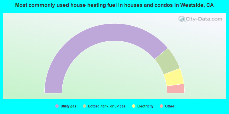
- 77.5%Utility gas
- 10.8%Bottled, tank, or LP gas
- 7.3%Electricity
- 3.7%Wood
- 0.4%No fuel used
- 0.1%Coal or coke
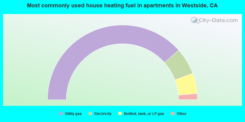
- 76.9%Utility gas
- 11.6%Electricity
- 8.9%Bottled, tank, or LP gas
- 1.7%Wood
- 0.8%No fuel used
Westside compared to California state average:
- Median house value significantly below state average.
- Black race population percentage below state average.
- Hispanic race population percentage below state average.
- Foreign-born population percentage significantly below state average.
- Renting percentage significantly below state average.
- Length of stay since moving in significantly above state average.
- Number of rooms per house significantly below state average.
- House age significantly below state average.
- Institutionalized population percentage significantly above state average.
- Percentage of population with a bachelor's degree or higher significantly below state average.
Westside on our top lists:
- #5 on the list of "Top 101 cities with largest percentage of females in occupations: extraction workers (population 5,000+)"
- #7 on the list of "Top 101 cities with largest percentage of males in occupations: extraction workers (population 5,000+)"
- #13 on the list of "Top 101 cities with largest percentage of males in occupations: material moving workers except supervisors and laborers and material movers, hand (population 5,000+)"
- #31 on the list of "Top 101 cities with largest percentage of females in occupations: material moving workers except supervisors and laborers and material movers, hand (population 5,000+)"
- #31 on the list of "Top 101 cities with largest percentage of males in occupations: supervisors of construction and extraction workers (population 5,000+)"
- #40 on the list of "Top 100 cities with largest land areas (pop. 5,000+)"
- #42 on the list of "Top 101 cities with largest percentage of females in industries: gasoline stations (population 5,000+)"
- #44 on the list of "Top 101 cities with largest percentage of females in occupations: pipelayers, plumbers, pipefitters, and steamfitters (population 5,000+)"
- #46 on the list of "Top 101 cities with the largest percentage of people in local jails and other confinement facilities (including police lockups) (population 1,000+)"
- #51 on the list of "Top 101 cities with largest percentage of females in industries: u. s. postal service (population 5,000+)"
- #60 on the list of "Top 101 cities with largest percentage of females in industries: farm supplies merchant wholesalers (population 5,000+)"
- #61 on the list of "Top 101 cities with largest percentage of males in industries: mining, quarrying, and oil and gas extraction (population 5,000+)"
- #66 on the list of "Top 101 cities with largest percentage of females in industries: mining, quarrying, and oil and gas extraction (population 5,000+)"
- #82 on the list of "Top 101 cities with largest percentage of males in industries: petroleum and petroleum products merchant wholesalers (population 5,000+)"
- #6 on the list of "Top 101 counties with the highest Particulate Matter (PM10) Annual air pollution readings in 2012 (µg/m3)"
- #13 on the list of "Top 101 counties with the highest carbon monoxide air pollution readings in 2012 (ppm)"
- #13 on the list of "Top 101 counties with the highest lead air pollution readings in 2012 (µg/m3)"
- #13 on the list of "Top 101 counties with the lowest lead air pollution readings in 2012 (µg/m3)"
- #17 on the list of "Top 101 counties with the highest ground withdrawal of fresh water for public supply"