West Valley, California
Submit your own pictures of this place and show them to the world
- OSM Map
- General Map
- Google Map
- MSN Map

| Males: 14,598 | |
| Females: 14,997 |
| Median resident age: | 34.5 years |
| California median age: | 33.3 years |
Zip code: 95648
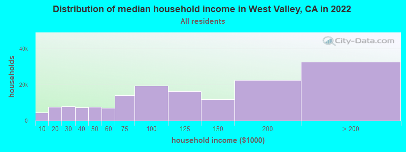
| West Valley: | $104,072 |
| CA: | $91,551 |
Estimated per capita income in 2022: $46,373 (it was $23,195 in 2000)
West Valley CCD income, earnings, and wages data
Estimated median house or condo value in 2022: $611,775 (it was $187,300 in 2000)
| West Valley: | $611,775 |
| CA: | $715,900 |
Mean prices in 2022: all housing units: $744,913; detached houses: $775,777; townhouses or other attached units: $646,401; in 2-unit structures: $520,744; in 3-to-4-unit structures: $391,510; in 5-or-more-unit structures: $385,040; mobile homes: $155,722; occupied boats, rvs, vans, etc.: $185,079
Detailed information about poverty and poor residents in West Valley, CA
Compare current foreclosures near West Valley, CA:
| Photo | Address | Area | Beds / Baths | Price | Details |
|---|---|---|---|---|---|

|
#1
Main Ave
Orangevale, CA 95662
|
1,160 sq. feet
|
2 baths 3 beds |
$515,000
|
show details |

|
#2
Peppermill Ct Apt 3
Sacramento, CA 95841
|
1,105 sq. feet
|
2 baths 3 beds |
show details | |

|
#3
Falworth St
Citrus Heights, CA 95621
|
1,414 sq. feet
|
2 baths 3 beds |
show details | |

|
#4
Tanana River Ct
Citrus Heights, CA 95610
|
1,673 sq. feet
|
2 baths 3 beds |
show details | |

|
#5
Black Eagle Dr
Antelope, CA 95843
|
1,256 sq. feet
|
2 baths 3 beds |
show details | |

|
#6
Jaytee Way
Fair Oaks, CA 95628
|
1,989 sq. feet
|
3 baths 3 beds |
show details | |

|
#7
G St
Rio Linda, CA 95673
|
1,328 sq. feet
|
1 baths 3 beds |
show details | |

|
#8
Silverton Way
Carmichael, CA 95608
|
1,164 sq. feet
|
1 baths 2 beds |
show details | |

|
#9
K St
Rio Linda, CA 95673
|
999 sq. feet
|
1 baths 2 beds |
show details | |

|
#10
Talon Rd
Rocklin, CA 95765
|
1,806 sq. feet
|
2 baths 4 beds |
show details |
| Photo | Address | Area | Beds / Baths | Price | Details |
|---|---|---|---|---|---|

|
#11
Mount Darwin Ct
Roseville, CA 95747
|
2,573 sq. feet
|
2 baths 4 beds |
show details | |

|
#12
Perrara Ct
Roseville, CA 95747
|
- sq. feet
|
2 baths 4 beds |
show details | |

|
#13
Barnwood Ln
Roseville, CA 95747
|
3,120 sq. feet
|
3 baths 5 beds |
show details | |

|
#14
Westchester Way
Citrus Heights, CA 95621
|
1,464 sq. feet
|
2 baths 4 beds |
show details | |

|
#15
Casa Alegre
Carmichael, CA 95608
|
1,166 sq. feet
|
2 baths 2 beds |
show details | |

|
#16
Ahrentzen Ct
Citrus Heights, CA 95610
|
1,408 sq. feet
|
2 baths 3 beds |
show details | |

|
#17
Muldrow Rd
Sacramento, CA 95841
|
1,449 sq. feet
|
2 baths 4 beds |
show details | |

|
#18
Cougar Hills Way
Antelope, CA 95843
|
1,468 sq. feet
|
2 baths 3 beds |
show details | |

|
#19
Broken Top Ct
Folsom, CA 95630
|
4,963 sq. feet
|
4 baths 4 beds |
show details | |

|
#20
Greenback Ln
Citrus Heights, CA 95621
|
1,344 sq. feet
|
2 baths 3 beds |
show details |
| Photo | Address | Area | Beds / Baths | Price | Details |
|---|---|---|---|---|---|

|
#21
Greenback Ln Apt 1
Citrus Heights, CA 95621
|
795 sq. feet
|
1 baths 2 beds |
show details | |

|
#22
Cobb St
Citrus Heights, CA 95610
|
2,395 sq. feet
|
3 baths 3 beds |
show details | |

|
#23
Midas Ave
Rocklin, CA 95677
|
2,519 sq. feet
|
2 baths 3 beds |
show details | |

|
#24
Floral Dr
North Highlands, CA 95660
|
1,156 sq. feet
|
2 baths 3 beds |
show details | |

|
#25
Olivine Ave
Citrus Heights, CA 95610
|
2,464 sq. feet
|
3 baths 7 beds |
show details | |

|
#26
Florence Ct
Auburn, CA 95602
|
1,992 sq. feet
|
1 baths 2 beds |
show details | |

|
#27
Trenton Way
Citrus Heights, CA 95621
|
1,104 sq. feet
|
2 baths 3 beds |
show details | |

|
#28
Bell Brook Dr
Auburn, CA 95602
|
2,608 sq. feet
|
2 baths 2 beds |
show details | |

|
#29
Bainbridge Dr
North Highlands, CA 95660
|
901 sq. feet
|
1 baths 3 beds |
show details | |

|
#30
Sungarden Dr
Citrus Heights, CA 95610
|
1,643 sq. feet
|
2 baths 4 beds |
show details |
| Photo | Address | Area | Beds / Baths | Price | Details |
|---|---|---|---|---|---|

|
#31
Jack London Ct
Roseville, CA 95747
|
2,015 sq. feet
|
3 baths 4 beds |
show details | |

|
#32
Zenith Dr
Citrus Heights, CA 95621
|
1,232 sq. feet
|
2 baths 3 beds |
show details | |

|
#33
Old Orchard Way
Orangevale, CA 95662
|
2,078 sq. feet
|
2 baths 4 beds |
show details | |

|
#34
Stanford Oak Dr
Sacramento, CA 95842
|
1,578 sq. feet
|
2 baths 4 beds |
show details | |

|
#35
Zachis Way
Antelope, CA 95843
|
1,577 sq. feet
|
2 baths 3 beds |
show details | |

|
#36
Palomino Ln
North Highlands, CA 95660
|
2,004 sq. feet
|
2 baths 4 beds |
show details | |

|
#37
Red Clover Way
Lincoln, CA 95648
|
1,343 sq. feet
|
2 baths 3 beds |
show details | |

|
#38
Isles Ct
Fair Oaks, CA 95628
|
1,612 sq. feet
|
2 baths 3 beds |
show details | |

|
#39
246 Lariat
Lincoln, CA 95648
|
1,815 sq. feet
|
2 baths 2 beds |
show details | |

|
#40
Portello Way
Lincoln, CA 95648
|
2,927 sq. feet
|
4 baths 4 beds |
show details |
| Photo | Address | Area | Beds / Baths | Price | Details |
|---|---|---|---|---|---|

|
#41
Scotch Ct
Carmichael, CA 95608
|
2,086 sq. feet
|
3 baths 4 beds |
show details | |

|
#42
Pinehurst Dr
Roseville, CA 95747
|
4,723 sq. feet
|
3 baths 5 beds |
show details | |

|
#43
Hunters Glen Pl
Antelope, CA 95843
|
2,244 sq. feet
|
3 baths 4 beds |
show details | |

|
#44
Cherbourg Dr
Sacramento, CA 95842
|
838 sq. feet
|
1 baths 2 beds |
show details | |

|
#45
Skylane Dr
Citrus Heights, CA 95621
|
1,073 sq. feet
|
1 baths 3 beds |
show details | |

|
#46
Chapel Hill Ln
Sacramento, CA 95842
|
1,831 sq. feet
|
2 baths 4 beds |
show details | |

|
#47
Saginaw Way
Citrus Heights, CA 95610
|
2,314 sq. feet
|
3 baths 4 beds |
show details | |

|
#48
Irvindale Way
Antelope, CA 95843
|
1,336 sq. feet
|
2 baths 3 beds |
show details | |

|
#49
Calloway Cir
Auburn, CA 95603
|
1,533 sq. feet
|
2 baths 3 beds |
show details | |

|
Check over 1 million property listings on Foreclosure.com!
|
browse all offers | |||

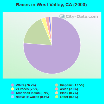
- 17,08376.2%White alone
- 3,91117.5%Hispanic
- 5692.5%Two or more races
- 4512.0%Asian alone
- 1930.9%American Indian alone
- 1480.7%Black alone
- 270.1%Native Hawaiian and Other
Pacific Islander alone - 260.1%Other race alone
 Recent articles from our blog. Our writers, many of them Ph.D. graduates or candidates, create easy-to-read articles on a wide variety of topics.
Current Local Time: PST time zone
Land area: 211.4 square miles.
Population density: 140 people per square mile (very low).

| West Valley CCD: | 0.8% ($1,490) |
| California: | 0.8% ($1,564) |
Nearest city with pop. 50,000+: Loomis Basin-Folsom Lake, CA  (9.1 miles , pop. 67,397).
Nearest city with pop. 200,000+: Sacramento, CA (24.4 miles , pop. 407,018).
Nearest city with pop. 1,000,000+: Los Angeles, CA (370.2 miles , pop. 3,694,820).
Nearest cities:
), ), )Latitude: 38.89 N, Longitude: 121.32 W
Area code commonly used in this area: 916

| Here: | 4.0% |
| California: | 5.1% |
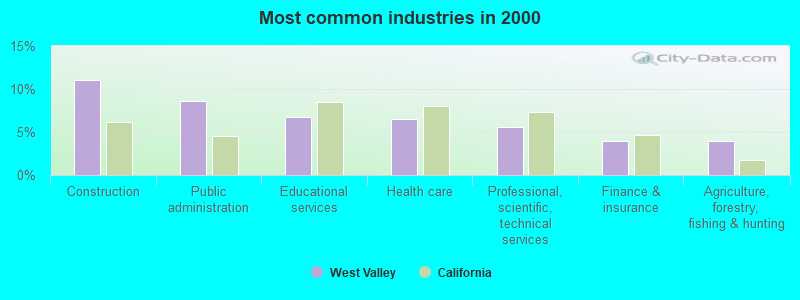
- Construction (11.1%)
- Public administration (8.7%)
- Educational services (6.7%)
- Health care (6.5%)
- Professional, scientific, technical services (5.6%)
- Finance & insurance (4.0%)
- Agriculture, forestry, fishing & hunting (3.9%)
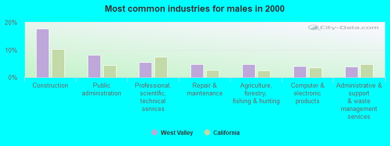
- Construction (17.7%)
- Public administration (8.1%)
- Professional, scientific, technical services (5.5%)
- Repair & maintenance (4.7%)
- Agriculture, forestry, fishing & hunting (4.7%)
- Computer & electronic products (4.1%)
- Administrative & support & waste management services (3.9%)
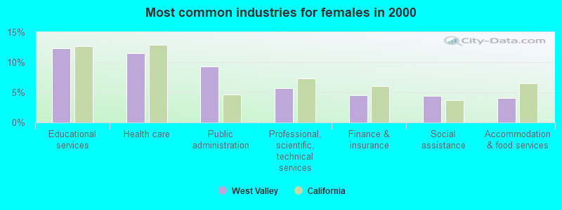
- Educational services (12.3%)
- Health care (11.5%)
- Public administration (9.3%)
- Professional, scientific, technical services (5.8%)
- Finance & insurance (4.6%)
- Social assistance (4.4%)
- Accommodation & food services (4.1%)
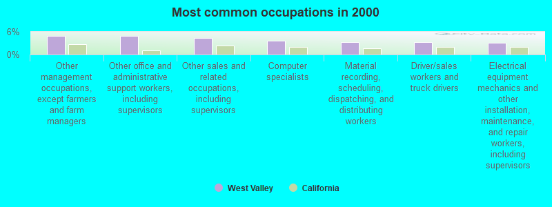
- Other management occupations, except farmers and farm managers (5.0%)
- Other office and administrative support workers, including supervisors (4.9%)
- Other sales and related occupations, including supervisors (4.4%)
- Computer specialists (3.6%)
- Material recording, scheduling, dispatching, and distributing workers (3.3%)
- Driver/sales workers and truck drivers (3.3%)
- Electrical equipment mechanics and other installation, maintenance, and repair workers, including supervisors (3.1%)
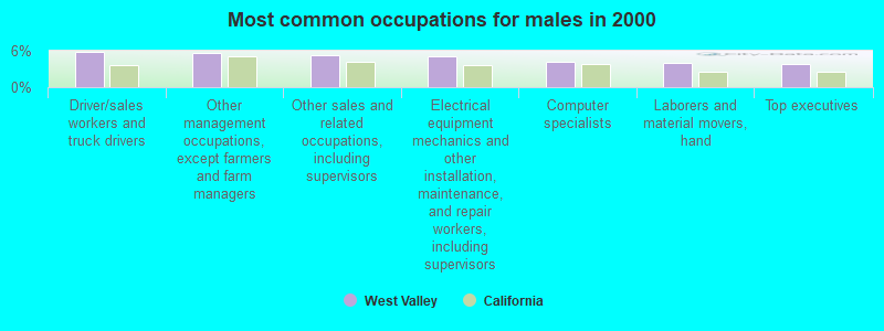
- Driver/sales workers and truck drivers (5.8%)
- Other management occupations, except farmers and farm managers (5.7%)
- Other sales and related occupations, including supervisors (5.3%)
- Electrical equipment mechanics and other installation, maintenance, and repair workers, including supervisors (5.1%)
- Computer specialists (4.1%)
- Laborers and material movers, hand (3.9%)
- Top executives (3.9%)
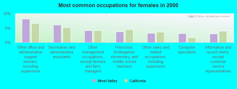
- Other office and administrative support workers, including supervisors (8.1%)
- Secretaries and administrative assistants (6.1%)
- Other management occupations, except farmers and farm managers (4.1%)
- Preschool, kindergarten, elementary, and middle school teachers (3.8%)
- Other sales and related occupations, including supervisors (3.2%)
- Computer specialists (3.1%)
- Information and record clerks, except customer service representatives (3.0%)
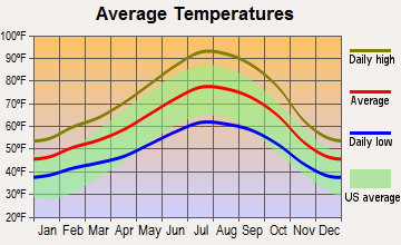
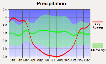
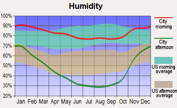
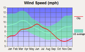
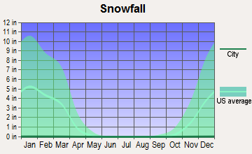
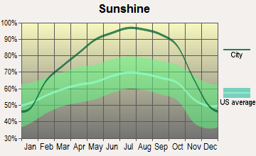
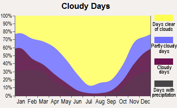
Average climate in West Valley, California
Based on data reported by over 4,000 weather stations
(lower is better)
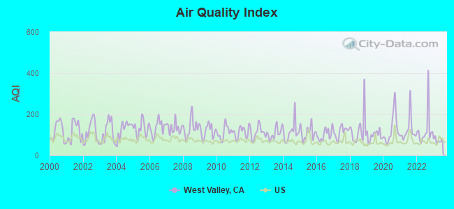
Air Quality Index (AQI) level in 2023 was 73.5. This is about average.
| City: | 73.5 |
| U.S.: | 72.6 |
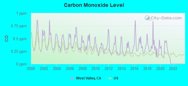
Carbon Monoxide (CO) [ppm] level in 2021 was 0.194. This is better than average. Closest monitor was 8.8 miles away from the city center.
| City: | 0.194 |
| U.S.: | 0.251 |
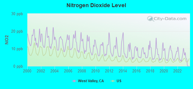
Nitrogen Dioxide (NO2) [ppb] level in 2022 was 6.25. This is worse than average. Closest monitor was 8.8 miles away from the city center.
| City: | 6.25 |
| U.S.: | 5.11 |
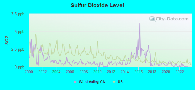
Sulfur Dioxide (SO2) [ppb] level in 2022 was 0.207. This is significantly better than average. Closest monitor was 12.7 miles away from the city center.
| City: | 0.207 |
| U.S.: | 1.515 |

Ozone [ppb] level in 2023 was 29.2. This is about average. Closest monitor was 0.5 miles away from the city center.
| City: | 29.2 |
| U.S.: | 33.3 |
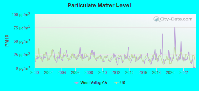
Particulate Matter (PM10) [µg/m3] level in 2022 was 18.3. This is about average. Closest monitor was 0.5 miles away from the city center.
| City: | 18.3 |
| U.S.: | 19.2 |
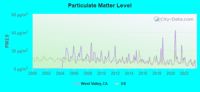
Particulate Matter (PM2.5) [µg/m3] level in 2023 was 5.21. This is significantly better than average. Closest monitor was 10.2 miles away from the city center.
| City: | 5.21 |
| U.S.: | 8.11 |
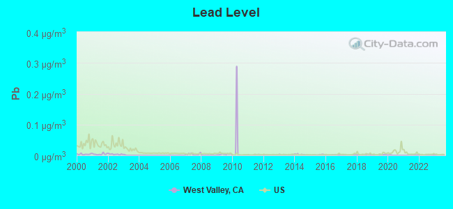
Lead (Pb) [µg/m3] level in 2023 was 0.00140. This is significantly better than average. Closest monitor was 10.2 miles away from the city center.
| City: | 0.00140 |
| U.S.: | 0.00931 |
Earthquake activity:
West Valley-area historical earthquake activity is significantly above California state average. It is 7481% greater than the overall U.S. average.On 4/18/1906 at 13:12:21, a magnitude 7.9 (7.9 UK, Class: Major, Intensity: VIII - XII) earthquake occurred 109.9 miles away from the city center, causing $524,000,000 total damage
On 10/3/1915 at 06:52:48, a magnitude 7.6 (7.6 UK) earthquake occurred 231.7 miles away from West Valley center
On 10/18/1989 at 00:04:15, a magnitude 7.1 (6.5 MB, 7.1 MS, 6.9 MW, 7.0 ML) earthquake occurred 125.5 miles away from West Valley center, causing 62 deaths (62 shaking deaths) and 3757 injuries, causing $1,305,032,704 total damage
On 1/31/1922 at 13:17:28, a magnitude 7.6 (7.6 UK) earthquake occurred 257.6 miles away from West Valley center
On 12/21/1932 at 06:10:09, a magnitude 7.2 (7.2 UK) earthquake occurred 176.5 miles away from West Valley center
On 4/25/1992 at 18:06:04, a magnitude 7.2 (6.3 MB, 7.1 MS, 7.2 MW, 7.1 MW, Depth: 9.4 mi) earthquake occurred 178.0 miles away from the city center, causing $75,000,000 total damage
Magnitude types: body-wave magnitude (MB), local magnitude (ML), surface-wave magnitude (MS), moment magnitude (MW)
Natural disasters:
The number of natural disasters in Placer County (17) is near the US average (15).Major Disasters (Presidential) Declared: 9
Emergencies Declared: 2
Causes of natural disasters: Floods: 10, Storms: 6, Fires: 4, Landslides: 4, Mudslides: 3, Winter Storms: 3, Drought: 1, Heavy Rain: 1, Hurricane: 1, Tornado: 1, Other: 1 (Note: some incidents may be assigned to more than one category).
Hospitals and medical centers near West Valley:
- CASA DEL MAR #3 (Hospital, about 7 miles away; PENRYN, CA)
- RAI FAIRWAY ROCKLIN (Dialysis Facility, about 8 miles away; ROCKLIN, CA)
- RAI SECRET RAVINE PARKWAY (Dialysis Facility, about 9 miles away; ROSEVILLE, CA)
- RAI HARDING BLVD (Dialysis Facility, about 10 miles away; ROSEVILLE, CA)
- KAISER FOUNDATION HOSPITAL - ROSEVILLE Acute Care Hospitals (about 10 miles away; ROSEVILLE, CA)
- MAXIM HEALTHCARE SERVICES, INC (Home Health Center, about 11 miles away; ROSEVILLE, CA)
- SUTTER VISITING NURSE ASSOCIATION AND HOSPICE (Home Health Center, about 11 miles away; ROSEVILLE, CA)
Amtrak stations near West Valley:
- 9 miles: ROCKLIN (ROCKLIN RD. & RAILROAD AVE.) - Bus Station . Services: partially wheelchair accessible, free short-term parking.
- 10 miles: ROSEVILLE (201 PACIFIC ST.) . Services: partially wheelchair accessible, public payphones, free short-term parking, free long-term parking, taxi stand, intercity bus service.
- 13 miles: AUBURN (NEVADA & FULWEILER STS.) - Bus Station . Services: fully wheelchair accessible, public payphones, free short-term parking.
Colleges/universities with over 2000 students nearest to West Valley:
- Sierra College (about 9 miles; Rocklin, CA; Full-time enrollment: 11,488)
- American River College (about 17 miles; Sacramento, CA; FT enrollment: 20,452)
- Folsom Lake College (about 19 miles; Folsom, CA; FT enrollment: 5,308)
- Yuba College (about 21 miles; Marysville, CA; FT enrollment: 4,737)
- Universal Technical Institute of Northern California Inc (about 21 miles; Sacramento, CA; FT enrollment: 3,193)
- University of Phoenix-Sacramento Valley Campus (about 22 miles; Sacramento, CA; FT enrollment: 2,855)
- California State University-Sacramento (about 24 miles; Sacramento, CA; FT enrollment: 22,234)
Points of interest:
Notable locations in West Valley: Brock (A), Camp Far West Ranch (B), Chamberlain Ranch (C), Sunnybrook Farm (D), Spring Valley Ranch (E), Lincoln Koi Farm (F), R F Fiddyment Ranch (G), Western Regional Landfill (H), Lincoln Rodeo Grounds (I), Sunset Whitney Industrial Park (J), Lincoln Public Library (K), Lincoln City Hall (L), Fruitvale Community Hall (M), Central Community Hall (N), Gold Hill Grange Hall (O), Placer County Fire Department Station 78 Sheridan (P), Placer County Fire Department Station 70 / Lincoln City Fire Department (Q), Placer County Fire Department Station 33 / Lincoln City Fire Department Station 1 (R), Placer County Fire Department Station 77 Sunset (S), Placer County Fire Department Station 35 / Lincoln City Fire Department Station 3 (T). Display/hide their locations on the map
Cemeteries: Manzanita Cemetery (1), Sheridan Cemetery (2). Display/hide their locations on the map
Reservoir: Valley View Reservoir (A). Display/hide its location on the map
Streams, rivers, and creeks: Ingram Slough (A), Kaseberg Creek (B), Doty Creek (C), Whisky Run (D), Alderman Creek (E), Orchard Creek (F). Display/hide their locations on the map
Parks in West Valley include: McBean Memorial Park (1), Sheridan Park (2). Display/hide their locations on the map
Birthplace of: Matt Harrington - Baseball player.
| This place: | 2.9 people |
| California: | 2.9 people |
| This place: | 64.0% |
| Whole state: | 69.4% |
| This place: | 4.9% |
| Whole state: | 5.9% |
Likely homosexual households (counted as self-reported same-sex unmarried-partner households)
- Lesbian couples: 0.3% of all households
- Gay men: 0.2% of all households
| This place: | 8.1% |
| Whole state: | 14.2% |
| This place: | 2.8% |
| Whole state: | 6.3% |
People in group quarters in West Valley in 2000:
- 114 people in nursing homes
- 11 people in homes for the mentally retarded
- 5 people in homes for the physically handicapped
- 5 people in other nonhousehold living situations
For population 15 years and over in West Valley:
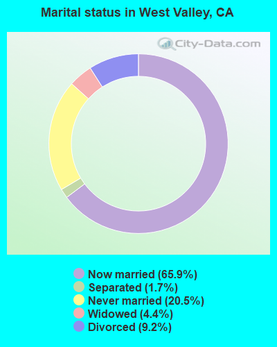
- Never married: 20.5%
- Now married: 65.9%
- Separated: 1.7%
- Widowed: 4.4%
- Divorced: 9.2%
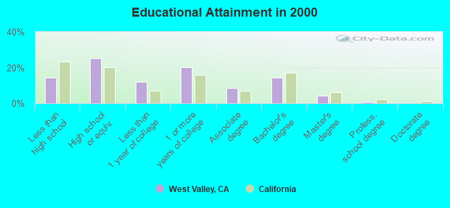
For population 25 years and over in West Valley:
- High school or higher: 85.8%
- Bachelor's degree or higher: 19.8%
- Graduate or professional degree: 5.5%
- Unemployed: 5.4%
- Mean travel time to work (commute): 28.4 minutes
| Here: | 11.0 |
| California average: | 16.1 |
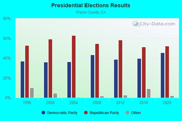
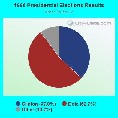
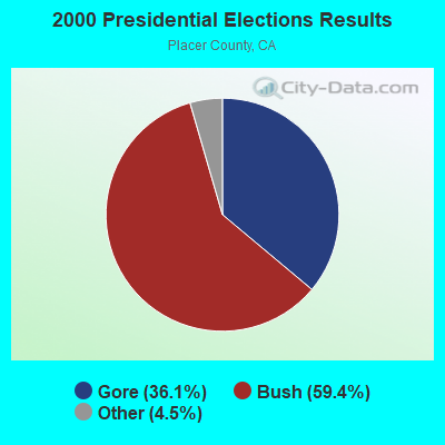
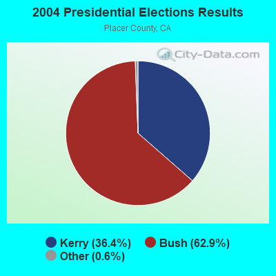
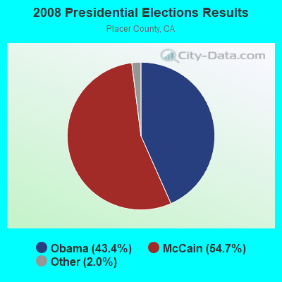
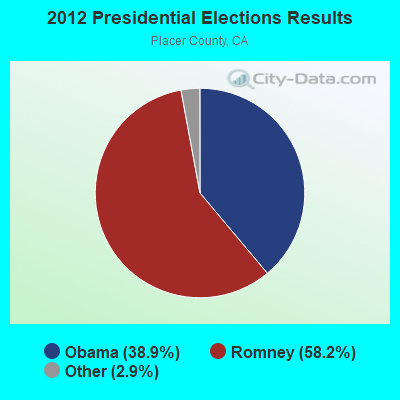
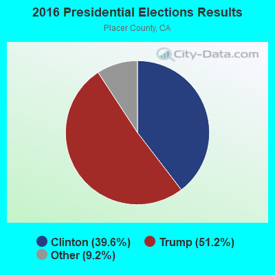
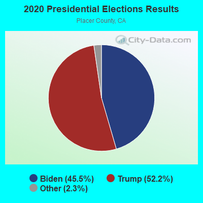
Graphs represent county-level data. Detailed 2008 Election Results
Religion statistics for West Valley, CA (based on Placer County data)
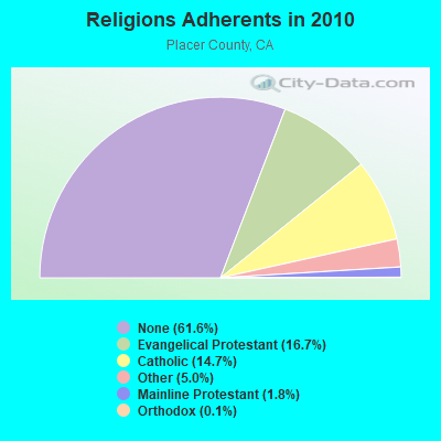
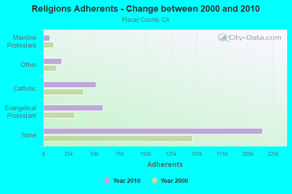
| Religion | Adherents | Congregations |
|---|---|---|
| Evangelical Protestant | 58,135 | 153 |
| Catholic | 51,342 | 12 |
| Other | 17,462 | 57 |
| Mainline Protestant | 6,376 | 30 |
| Orthodox | 400 | 1 |
| None | 214,717 | - |
Food Environment Statistics:
| This county: | 1.66 / 10,000 pop. |
| California: | 2.14 / 10,000 pop. |
| Here: | 0.06 / 10,000 pop. |
| State: | 0.04 / 10,000 pop. |
| Here: | 0.60 / 10,000 pop. |
| California: | 0.62 / 10,000 pop. |
| Here: | 2.23 / 10,000 pop. |
| State: | 1.49 / 10,000 pop. |
| This county: | 9.00 / 10,000 pop. |
| California: | 7.42 / 10,000 pop. |
| Placer County: | 6.7% |
| California: | 7.3% |
| Placer County: | 17.6% |
| California: | 21.3% |
| Placer County: | 14.5% |
| California: | 17.9% |
9.43% of this county's 2021 resident taxpayers lived in other counties in 2020 ($99,508 average adjusted gross income)
| Here: | 9.43% |
| California average: | 5.19% |
0.03% of residents moved from foreign countries ($239 average AGI)
Placer County: 0.03% California average: 0.03%
Top counties from which taxpayers relocated into this county between 2020 and 2021:
| from Sacramento County, CA | |
| from Santa Clara County, CA | |
| from Alameda County, CA |
8.04% of this county's 2020 resident taxpayers moved to other counties in 2021 ($95,121 average adjusted gross income)
| Here: | 8.04% |
| California average: | 6.14% |
0.03% of residents moved to foreign countries ($247 average AGI)
Placer County: 0.03% California average: 0.02%
Top counties to which taxpayers relocated from this county between 2020 and 2021:
| to Sacramento County, CA | |
| to Nevada County, CA | |
| to El Dorado County, CA |
Strongest AM radio stations in West Valley:
- KFIA (710 AM; 25 kW; CARMICHAEL, CA; Owner: VISTA BROADCASTING INC.)
- KFBK (1530 AM; 50 kW; SACRAMENTO, CA; Owner: AMFM RADIO LICENSES, L.L.C.)
- KLIB (1110 AM; 10 kW; ROSEVILLE, CA; Owner: WAY BROADCASTING, INC.)
- KSTE (650 AM; 25 kW; RANCHO CORDOVA, CA; Owner: AMFM RADIO LICENSES, L.L.C.)
- KFSG (1690 AM; 10 kW; ROSEVILLE, CA; Owner: WAY BROADCASTING, INC.)
- KAHI (950 AM; 10 kW; AUBURN, CA; Owner: IHR EDUCATIONAL BROADCASTING)
- KHTK (1140 AM; 50 kW; SACRAMENTO, CA; Owner: INFINITY RADIO SUBSIDIARY OPERATIONS INC.)
- KSMH (1620 AM; 10 kW; WEST SACRAMENTO, CA; Owner: IHR EDUCATIONAL BROADCASTING)
- KCBC (770 AM; 50 kW; RIVERBANK, CA; Owner: KIERTRON, INC.)
- KCBS (740 AM; 50 kW; SAN FRANCISCO, CA; Owner: INFINITY BROADCASTING OPERATIONS, INC.)
- KCTC (1320 AM; 5 kW; SACRAMENTO, CA; Owner: ENTERCOM SACRAMENTO LICENSE, LLC)
- KMYC (1410 AM; 5 kW; MARYSVILLE, CA; Owner: THOMAS F. HUTH)
- KNCO (830 AM; 5 kW; GRASS VALLEY, CA; Owner: NEVADA COUNTY BROADCASTERS, INC.)
Strongest FM radio stations in West Valley:
- KXCL (103.9 FM; YUBA CITY, CA; Owner: HARLAN COMMUNICATIONS, INC.)
- KRCX-FM (99.9 FM; MARYSVILLE, CA; Owner: ENTRAVISION HOLDINGS, LLC)
- KMJE (101.5 FM; GRIDLEY, CA; Owner: RESULTS RADIO LICENSEE, LLC)
- K213BZ (90.5 FM; RICHVALE, CA; Owner: FAMILY STATIONS, INC.)
- KHYL (101.1 FM; AUBURN, CA; Owner: AMFM RADIO LICENSES, L.L.C.)
- KKCY (103.1 FM; COLUSA, CA; Owner: RESULTS RADIO LICENSEE, LLC)
- KXPR (90.9 FM; SACRAMENTO, CA; Owner: CALIFORNIA STATE UNIVERSITY)
- KGBY (92.5 FM; SACRAMENTO, CA; Owner: AMFM RADIO LICENSES, L.L.C.)
- KVMR (89.5 FM; NEVADA CITY, CA; Owner: NEVADA CITY COMMUNITY BROADCAST GRUP)
- KXOA (93.7 FM; ROSEVILLE, CA; Owner: INFINITY RADIO SUBSIDIARY OPERATIONS INC.)
- KLVS (99.3 FM; GRASS VALLEY, CA; Owner: EDUCATIONAL MEDIA FOUNDATION)
- KDND (107.9 FM; SACRAMENTO, CA; Owner: ENTERCOM SACRAMENTO LICENSE, LLC)
- KEDR (88.1 FM; SACRAMENTO, CA; Owner: FAMILY STATIONS, INC.)
- KNDL (89.9 FM; ANGWIN, CA; Owner: HOWELL MOUNTAIN BROADCASTING COMPANY)
- KKSF-FM1 (103.7 FM; PLEASANTON, ETC., CA; Owner: AMFM RADIO LICENSES, L.L.C.)
- KSEG (96.9 FM; SACRAMENTO, CA; Owner: ENTERCOM SACRAMENTO LICENSE, LLC)
- KNCO-FM (94.1 FM; GRASS VALLEY, CA; Owner: NEVADA COUNTY BROADCASTERS, INC.)
- KLVR (91.9 FM; SANTA ROSA, CA; Owner: EDUCATIONAL MEDIA FOUNDATION)
- KUIC (95.3 FM; VACAVILLE, CA; Owner: KUIC, INC.)
- KXTS (100.9 FM; CALISTOGA, CA; Owner: SINCLAIR TELECABLE, INC.)
TV broadcast stations around West Valley:
- K27FX (Channel 27; EUREKA, CA; Owner: MS COMMUNICATIONS, LLC)
- KEZT-CA (Channel 23; SACRAMENTO, CA; Owner: TELEFUTURA SACRAMENTO LLC)
- KMMK-LP (Channel 14; SACRAMENTO, CA; Owner: CABALLERO TELEVISION TEXAS, L.L.C.)
- K17EH (Channel 17; EUREKA, CA; Owner: MS COMMUNICATIONS, LLC)
- KSPX (Channel 29; SACRAMENTO, CA; Owner: PAXSON SACRAMENTO LICENSE, INC.)
- KTXL (Channel 40; SACRAMENTO, CA; Owner: CHANNEL 40, INC.)
- KQCA (Channel 58; STOCKTON, CA; Owner: KCRA HEARST-ARGYLE TELEVISION, INC.)
- KCRA-TV (Channel 3; SACRAMENTO, CA; Owner: KCRA HEARST-ARGYLE TELEVISION, INC.)
- KOVR (Channel 13; STOCKTON, CA; Owner: SCI - SACRAMENTO LICENSEE, LLC)
- KXTV (Channel 10; SACRAMENTO, CA; Owner: KXTV, INC.)
- K27EU (Channel 27; SACRAMENTO, CA; Owner: ABUNDANT LIFE BROADCASTING, INC.)
- KVIE (Channel 6; SACRAMENTO, CA; Owner: KVIE, INC.)
- KSAO-LP (Channel 49; SACRAMENTO, CA; Owner: GARY M. COCOLA FAMILY TRUST, GARY M. COCOLA TRUSTEE)
- KUVS (Channel 19; MODESTO, CA; Owner: KUVS LICENSE PARTNERSHIP, G.P.)
- KMAX-TV (Channel 31; SACRAMENTO, CA; Owner: UPN STATIONS GROUP INC.)
- KBTV-LP (Channel 8; SACRAMENTO, CA; Owner: INCISOR COMMUNICATIONS, L.L.C.)
- KMUM-CA (Channel 15; SACRAMENTO, CA; Owner: CABALLERO TELEVISION TEXAS, L.L.C.)
- K22FR (Channel 22; SACRAMENTO, CA; Owner: NATIONAL MINORITY T.V., INC.)
- K69FB (Channel 69; SACRAMENTO, CA; Owner: TRINITY BROADCASTING NETWORK)
- KCSO-LP (Channel 33; SACRAMENTO, CA; Owner: SAINTE 51, L.P.)
- KRJR-LP (Channel 47; SACRAMENTO, CA; Owner: WORD OF GOD FELLOWSHIP, INC.)
- KGTN-LP (Channel 62; PLACERVILLE, CA; Owner: PRAISE THE LORD STUDIO CHAPEL)
FCC Registered Microwave Towers:
1- SC14640B MAR, 1900 Wildcat Blvd (Lat: 38.820583 Lon: -121.283722), Type: Pole, Structure height: 24.4 m, Overall height: 25.3 m, Call Sign: WQIN980, Licensee ID: L00127664,
Assigned Frequencies: 19405.0 MHz, Grant Date: 04/01/2008, Expiration Date: 04/01/2018, Cancellation Date: 06/02/2018, Certifier: Dan Menser, Registrant: T-Mobile License LLC, 12920 Se 38th Street, Bellevue, WA 98006, Phone: (425) 383-4000, Fax: (425) 383-4040, Email:
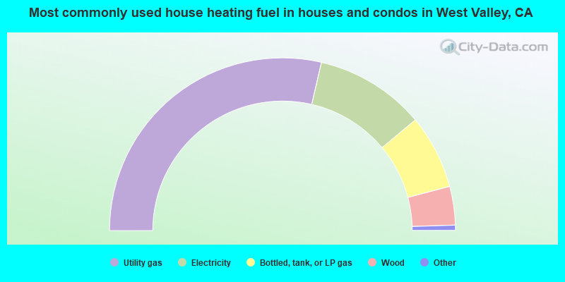
- 57.2%Utility gas
- 20.6%Electricity
- 13.9%Bottled, tank, or LP gas
- 7.2%Wood
- 0.5%Other fuel
- 0.5%Fuel oil, kerosene, etc.
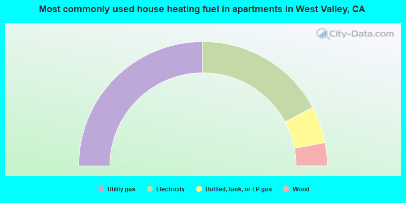
- 49.8%Utility gas
- 34.5%Electricity
- 9.6%Bottled, tank, or LP gas
- 6.0%Wood
West Valley compared to California state average:
- Unemployed percentage significantly below state average.
- Black race population percentage significantly below state average.
- Hispanic race population percentage below state average.
- Foreign-born population percentage significantly below state average.
- Renting percentage significantly below state average.
- Length of stay since moving in significantly above state average.
- Number of rooms per house significantly below state average.
- House age significantly below state average.
- Institutionalized population percentage significantly above state average.
West Valley on our top lists:
- #27 on the list of "Top 101 cities with largest percentage of females in industries: professional and commercial equipment and supplies merchant wholesalers (population 5,000+)"
- #29 on the list of "Top 101 cities with largest percentage of males in industries: furniture and related product manufacturing (population 5,000+)"
- #33 on the list of "Top 101 cities with largest percentage of females in industries: repair and maintenance (population 5,000+)"
- #42 on the list of "Top 101 cities with largest percentage of males in industries: lumber and other construction materials merchant wholesalers (population 5,000+)"
- #47 on the list of "Top 101 cities with largest percentage of females in occupations: supervisors of construction and extraction workers (population 5,000+)"
- #52 on the list of "Top 101 cities with largest percentage of females in occupations: agricultural workers including supervisors (population 5,000+)"
- #55 on the list of "Top 101 cities with largest percentage of females in occupations: entertainers and performers, sports, and related workers (population 5,000+)"
- #58 on the list of "Top 101 cities with largest percentage of males in industries: music stores (population 5,000+)"
- #60 on the list of "Top 101 cities with largest percentage of females in industries: warehousing and storage (population 5,000+)"
- #62 on the list of "Top 101 cities with the most people taking a motorcycle to work (population 5,000+)"
- #68 on the list of "Top 101 cities with largest percentage of males in occupations: customer service representatives (population 5,000+)"
- #72 on the list of "Top 101 cities with largest percentage of males in occupations: communications equipment operators (population 5,000+)"
- #88 on the list of "Top 101 cities with largest percentage of females in occupations: woodworkers (population 5,000+)"
- #90 on the list of "Top 101 cities with largest percentage of males in industries: farm product raw materials merchant wholesalers (population 5,000+)"
- #95 on the list of "Top 101 cities with largest percentage of females in industries: computer and electronic products (population 5,000+)"
- #11 on the list of "Top 101 counties with the highest lead air pollution readings in 2012 (µg/m3)"
- #19 on the list of "Top 101 counties with the lowest lead air pollution readings in 2012 (µg/m3)"
- #31 on the list of "Top 101 counties with the highest Nitrogen Dioxide air pollution readings in 2012 (ppm)"
- #32 on the list of "Top 101 counties with the lowest Particulate Matter (PM2.5) Annual air pollution readings in 2012 (µg/m3)"
- #48 on the list of "Top 101 counties with the lowest Particulate Matter (PM10) Annual air pollution readings in 2012 (µg/m3)"