Lowell, Arkansas
Submit your own pictures of this city and show them to the world
- OSM Map
- General Map
- Google Map
- MSN Map
Population change since 2000: +120.4%
| Males: 5,375 | |
| Females: 5,675 |
| Median resident age: | 34.7 years |
| Arkansas median age: | 38.9 years |
Zip codes: 72745.
| Lowell: | $84,464 |
| AR: | $55,432 |
Estimated per capita income in 2022: $33,607 (it was $20,861 in 2000)
Lowell city income, earnings, and wages data
Estimated median house or condo value in 2022: $271,498 (it was $89,200 in 2000)
| Lowell: | $271,498 |
| AR: | $179,800 |
Mean prices in 2022: all housing units: $305,215; detached houses: $315,081; townhouses or other attached units: $238,756; in 2-unit structures: $206,405; in 3-to-4-unit structures: $409,496; in 5-or-more-unit structures: $258,464; mobile homes: $114,218; occupied boats, rvs, vans, etc.: $76,394
Median gross rent in 2022: $1,035.
(4.2% for White Non-Hispanic residents, 7.3% for Hispanic or Latino residents, 92.1% for Native Hawaiian and other Pacific Islander residents, 8.0% for two or more races residents)
Detailed information about poverty and poor residents in Lowell, AR


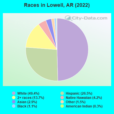
- 5,22949.4%White alone
- 2,80226.5%Hispanic
- 1,45113.7%Two or more races
- 4464.2%Native Hawaiian and Other
Pacific Islander alone - 3042.9%Asian alone
- 1561.5%Other race alone
- 1151.1%Black alone
- 290.3%American Indian alone
According to our research of Arkansas and other state lists, there were 22 registered sex offenders living in Lowell, Arkansas as of May 23, 2024.
The ratio of all residents to sex offenders in Lowell is 398 to 1.
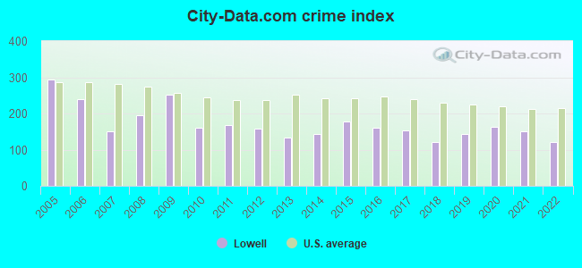
Type |
2009 |
2010 |
2011 |
2012 |
2013 |
2014 |
2015 |
2016 |
2017 |
2018 |
2019 |
2020 |
2021 |
2022 |
|---|---|---|---|---|---|---|---|---|---|---|---|---|---|---|
| Murders (per 100,000) | 0 (0.0) | 0 (0.0) | 0 (0.0) | 0 (0.0) | 0 (0.0) | 0 (0.0) | 0 (0.0) | 0 (0.0) | 0 (0.0) | 0 (0.0) | 0 (0.0) | 0 (0.0) | 0 (0.0) | 0 (0.0) |
| Rapes (per 100,000) | 5 (67.6) | 4 (54.6) | 2 (27.1) | 0 (0.0) | 3 (38.3) | 4 (49.4) | 3 (34.9) | 9 (102.1) | 7 (75.9) | 3 (31.5) | 3 (30.9) | 4 (40.7) | 4 (39.3) | 4 (38.5) |
| Robberies (per 100,000) | 1 (13.5) | 0 (0.0) | 0 (0.0) | 1 (13.2) | 0 (0.0) | 1 (12.4) | 1 (11.6) | 1 (11.3) | 0 (0.0) | 3 (31.5) | 1 (10.3) | 0 (0.0) | 1 (9.8) | 0 (0.0) |
| Assaults (per 100,000) | 11 (148.7) | 7 (95.5) | 6 (81.3) | 9 (119.0) | 3 (38.3) | 10 (123.5) | 18 (209.3) | 6 (68.1) | 12 (130.2) | 13 (136.5) | 24 (246.8) | 23 (234.1) | 24 (236.0) | 18 (173.0) |
| Burglaries (per 100,000) | 117 (1,582) | 49 (668.8) | 60 (812.8) | 55 (727.0) | 35 (446.9) | 28 (345.8) | 52 (604.5) | 38 (431.2) | 41 (444.7) | 37 (388.6) | 40 (411.4) | 64 (651.4) | 46 (452.3) | 49 (471.1) |
| Thefts (per 100,000) | 90 (1,217) | 77 (1,051) | 116 (1,571) | 126 (1,666) | 108 (1,379) | 94 (1,161) | 119 (1,383) | 63 (714.9) | 65 (705.0) | 61 (640.6) | 72 (740.5) | 75 (763.4) | 71 (698.1) | 50 (480.7) |
| Auto thefts (per 100,000) | 4 (54.1) | 9 (122.8) | 10 (135.5) | 12 (158.6) | 9 (114.9) | 4 (49.4) | 9 (104.6) | 3 (34.0) | 9 (97.6) | 9 (94.5) | 9 (92.6) | 10 (101.8) | 11 (108.2) | 3 (28.8) |
| Arson (per 100,000) | 1 (13.5) | 0 (0.0) | 0 (0.0) | 1 (13.2) | 0 (0.0) | 0 (0.0) | 0 (0.0) | 0 (0.0) | 0 (0.0) | 0 (0.0) | 0 (0.0) | 0 (0.0) | 0 (0.0) | 0 (0.0) |
| City-Data.com crime index | 251.6 | 161.5 | 168.5 | 158.0 | 133.9 | 142.5 | 179.3 | 160.2 | 153.9 | 122.3 | 143.0 | 163.7 | 149.8 | 119.9 |
The City-Data.com crime index weighs serious crimes and violent crimes more heavily. Higher means more crime, U.S. average is 246.1. It adjusts for the number of visitors and daily workers commuting into cities.
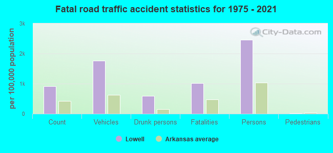
Crime rate in Lowell detailed stats: murders, rapes, robberies, assaults, burglaries, thefts, arson
Full-time law enforcement employees in 2021, including police officers: 29 (23 officers - 21 male; 2 female).
| Officers per 1,000 residents here: | 2.26 |
| Arkansas average: | 2.25 |
 Recent articles from our blog. Our writers, many of them Ph.D. graduates or candidates, create easy-to-read articles on a wide variety of topics.


Latest news from Lowell, AR collected exclusively by city-data.com from local newspapers, TV, and radio stations
Ancestries: American (10.5%), Irish (5.8%), English (5.1%), German (3.5%), European (2.8%), Polish (1.3%).
Current Local Time: CST time zone
Elevation: 1342 feet
Land area: 6.26 square miles.
Population density: 1,765 people per square mile (low).
1,655 residents are foreign born (11.3% Latin America, 3.1% Asia).
| This city: | 15.7% |
| Arkansas: | 5.0% |
Median real estate property taxes paid for housing units with mortgages in 2022: $1,919 (0.7%)
Median real estate property taxes paid for housing units with no mortgage in 2022: $1,298 (0.7%)
Nearest city with pop. 50,000+: Fayetteville, AR  (12.8 miles , pop. 58,047).
Nearest city with pop. 200,000+: Tulsa, OK (100.7 miles , pop. 393,049).
Nearest city with pop. 1,000,000+: Dallas, TX (282.9 miles , pop. 1,188,580).
Nearest cities:
), ), ), ), Latitude: 36.26 N, Longitude: 94.14 W
Daytime population change due to commuting: +6,011 (+56.8%)
Workers who live and work in this city: 1,458 (27.5%)
Area code commonly used in this area: 479

Lowell, Arkansas accommodation & food services, waste management - Economy and Business Data
Single-family new house construction building permits:
- 2022: 75 buildings, average cost: $338,500
- 2021: 363 buildings, average cost: $244,000
- 2020: 126 buildings, average cost: $269,700
- 2019: 127 buildings, average cost: $326,600
- 2018: 83 buildings, average cost: $325,400
- 2017: 107 buildings, average cost: $286,600
- 2016: 104 buildings, average cost: $227,200
- 2015: 113 buildings, average cost: $222,700
- 2014: 62 buildings, average cost: $267,400
- 2013: 114 buildings, average cost: $287,700
- 2012: 75 buildings, average cost: $279,600
- 2011: 29 buildings, average cost: $257,300
- 2010: 34 buildings, average cost: $178,700
- 2009: 24 buildings, average cost: $161,300
- 2008: 9 buildings, average cost: $196,300
- 2007: 16 buildings, average cost: $185,600
- 2006: 37 buildings, average cost: $238,700
- 2005: 24 buildings, average cost: $315,500
- 2004: 17 buildings, average cost: $188,200
- 2003: 32 buildings, average cost: $156,800
- 2002: 132 buildings, average cost: $135,400
- 2001: 221 buildings, average cost: $128,900
- 2000: 117 buildings, average cost: $117,600
- 1999: 149 buildings, average cost: $80,100
- 1998: 171 buildings, average cost: $72,700
- 1997: 188 buildings, average cost: $73,400
| Here: | 2.5% |
| Arkansas: | 3.4% |
- Department & other general merchandise stores (13.2%)
- Finance & insurance (8.4%)
- Truck transportation (6.0%)
- Health care (5.7%)
- Food (5.7%)
- Educational services (5.6%)
- Construction (4.8%)
- Department & other general merchandise stores (11.8%)
- Construction (7.4%)
- Finance & insurance (5.7%)
- Professional, scientific, technical services (5.4%)
- Metal & metal products (5.3%)
- Motor vehicle & parts dealers (5.0%)
- Food (4.8%)
- Department & other general merchandise stores (15.0%)
- Finance & insurance (11.9%)
- Educational services (11.8%)
- Health care (10.8%)
- Truck transportation (7.7%)
- Food (6.8%)
- Social assistance (4.1%)
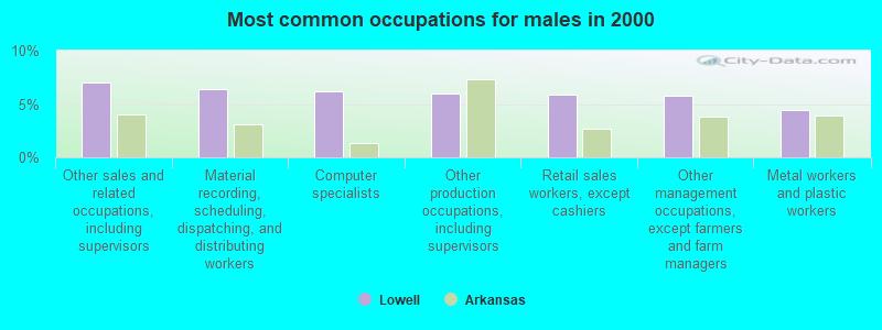
- Other sales and related occupations, including supervisors (6.0%)
- Other production occupations, including supervisors (5.5%)
- Other office and administrative support workers, including supervisors (5.2%)
- Computer specialists (5.1%)
- Other management occupations, except farmers and farm managers (5.0%)
- Material recording, scheduling, dispatching, and distributing workers (4.9%)
- Retail sales workers, except cashiers (3.6%)
- Other sales and related occupations, including supervisors (7.0%)
- Material recording, scheduling, dispatching, and distributing workers (6.4%)
- Computer specialists (6.2%)
- Other production occupations, including supervisors (6.0%)
- Retail sales workers, except cashiers (5.8%)
- Other management occupations, except farmers and farm managers (5.8%)
- Metal workers and plastic workers (4.4%)
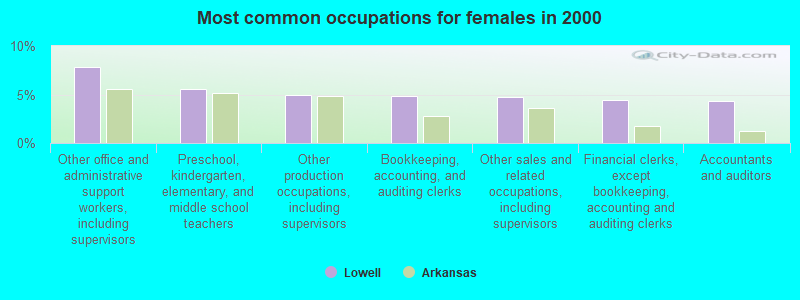
- Other office and administrative support workers, including supervisors (7.8%)
- Preschool, kindergarten, elementary, and middle school teachers (5.6%)
- Other production occupations, including supervisors (4.9%)
- Bookkeeping, accounting, and auditing clerks (4.8%)
- Other sales and related occupations, including supervisors (4.7%)
- Financial clerks, except bookkeeping, accounting and auditing clerks (4.4%)
- Accountants and auditors (4.3%)
Average climate in Lowell, Arkansas
Based on data reported by over 4,000 weather stations


|
|

(lower is better)
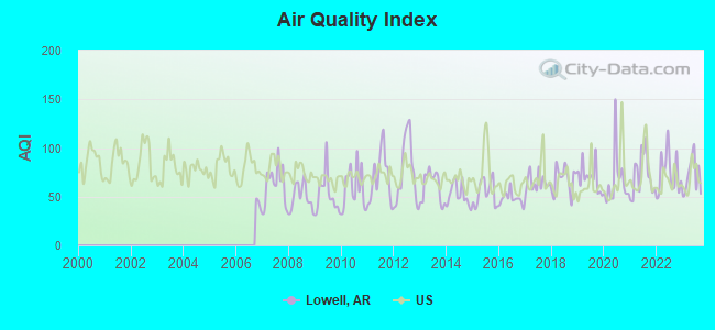
Air Quality Index (AQI) level in 2023 was 71.4. This is about average.
| City: | 71.4 |
| U.S.: | 72.6 |
Ozone [ppb] level in 2023 was 32.8. This is about average. Closest monitor was 5.7 miles away from the city center.
| City: | 32.8 |
| U.S.: | 33.3 |
Particulate Matter (PM2.5) [µg/m3] level in 2022 was 8.95. This is about average. Closest monitor was 5.7 miles away from the city center.
| City: | 8.95 |
| U.S.: | 8.11 |
Tornado activity:
Lowell-area historical tornado activity is near Arkansas state average. It is 87% greater than the overall U.S. average.
On 3/24/1954, a category F3 (max. wind speeds 158-206 mph) tornado 10.0 miles away from the Lowell city center injured 4 people and caused between $500 and $5000 in damages.
On 4/30/1954, a category F3 tornado 13.6 miles away from the city center injured one person and caused between $50,000 and $500,000 in damages.
Earthquake activity:
Lowell-area historical earthquake activity is significantly above Arkansas state average. It is 639% greater than the overall U.S. average.On 9/3/2016 at 12:02:44, a magnitude 5.8 (5.8 MW, Depth: 3.5 mi, Class: Moderate, Intensity: VI - VII) earthquake occurred 155.8 miles away from the city center
On 11/6/2011 at 03:53:10, a magnitude 5.7 (5.7 MW, Depth: 3.2 mi) earthquake occurred 155.5 miles away from the city center
On 11/7/2016 at 01:44:24, a magnitude 5.0 (5.0 MW, Depth: 2.8 mi) earthquake occurred 150.0 miles away from the city center
On 2/28/2011 at 05:00:50, a magnitude 4.7 (4.7 MW, Depth: 2.0 mi, Class: Light, Intensity: IV - V) earthquake occurred 121.4 miles away from Lowell center
On 5/4/2001 at 06:42:12, a magnitude 4.7 (4.2 MB, 4.7 LG, 4.5 LG) earthquake occurred 131.4 miles away from Lowell center
On 1/21/1982 at 00:33:54, a magnitude 4.7 (4.5 MB, 4.7 LG, 4.5 LG) earthquake occurred 132.1 miles away from Lowell center
Magnitude types: regional Lg-wave magnitude (LG), body-wave magnitude (MB), moment magnitude (MW)
Natural disasters:
The number of natural disasters in Benton County (20) is greater than the US average (15).Major Disasters (Presidential) Declared: 14
Emergencies Declared: 4
Causes of natural disasters: Floods: 13, Storms: 13, Tornadoes: 6, Winter Storms: 4, Winds: 2, Drought: 1, Hurricane: 1, Other: 1 (Note: some incidents may be assigned to more than one category).

Main business address for: HUNT J B TRANSPORT SERVICES INC (TRUCKING (NO LOCAL)).
Hospitals and medical centers in Lowell:
Other hospitals and medical centers near Lowell:
- SHILOH NURSING AND REHAB, LLC (Nursing Home, about 4 miles away; SPRINGDALE, AR)
- NEW HOPE HEALTH AND REHABILITATION, LLC (Nursing Home, about 4 miles away; ROGERS, AR)
- HOLLAND NURSING CENTER NORTH INC (Nursing Home, about 4 miles away; SPRINGDALE, AR)
- WINDCREST HEALTH AND REHAB INC (Nursing Home, about 4 miles away; SPRINGDALE, AR)
- JAMESTOWN NURSING AND REHAB, LLC (Nursing Home, about 4 miles away; ROGERS, AR)
- HERITAGE PARK NURSING CENTER (Nursing Home, about 5 miles away; ROGERS, AR)
- INNISFREE HEALTH AND REHAB, LLC (Nursing Home, about 6 miles away; ROGERS, AR)
Airports located in Lowell:
- Circle S Farms Airport (AR91) (Runways: 1)
- Taylor Field Airport (3AR7) (Runways: 1)
Colleges/universities with over 2000 students nearest to Lowell:
- NorthWest Arkansas Community College (about 7 miles; Bentonville, AR; Full-time enrollment: 5,634)
- University of Arkansas (about 14 miles; Fayetteville, AR; FT enrollment: 22,163)
- John Brown University (about 24 miles; Siloam Springs, AR; FT enrollment: 2,097)
- Crowder College (about 41 miles; Neosho, MO; FT enrollment: 3,675)
- Northeastern State University (about 52 miles; Tahlequah, OK; FT enrollment: 6,895)
- Northeastern Oklahoma A&M College (about 59 miles; Miami, OK; FT enrollment: 2,075)
- Missouri Southern State University (about 61 miles; Joplin, MO; FT enrollment: 4,456)
Public elementary/middle schools in Lowell:
- ELZA R. TUCKER ELEM. SCHOOL (Location: 121 SCHOOL AVE, Grades: PK-5)
- LOWELL ELEMENTARY SCHOOL (Location: 202 MCCLURE RD, Grades: PK-5)
Private elementary/middle school in Lowell:
Points of interest:
Notable locations in Lowell: Lowell Police Department (A), Lowell Fire Station 41 (B). Display/hide their locations on the map
Main business address in Lowell: HUNT J B TRANSPORT SERVICES INC (A). Display/hide its location on the map
Church in Lowell: Pleasant Grove Church (A). Display/hide its location on the map
Cemetery: Pleasant Grove Cemetery (1). Display/hide its location on the map
Tourist attraction: Torres Tours (Tours & Charters; 310 North Bloomington Street).
Hotel: Ramada Inn Lowell (509 Hospitality Avenue).
Drinking water stations with addresses in Lowell and their reported violations in the past:
BENTON COUNTY WATER AUTHORITY5 (Population served: 1,505, Purch surface water):Past health violations:BENTON COUNTY WATER AUTHORITY4 (Population served: 523, Purch surface water):Past monitoring violations:
- MCL, Monthly (TCR) - In OCT-2011, Contaminant: Coliform. Follow-up actions: St Public Notif requested (DEC-05-2011), St Compliance achieved (MAR-27-2012)
- MCL, Monthly (TCR) - In OCT-2010, Contaminant: Coliform. Follow-up actions: St Public Notif requested (DEC-09-2010), St Compliance achieved (MAY-04-2011)
- Monitoring and Reporting (DBP) - Between OCT-2005 and DEC-2005, Contaminant: Chlorine. Follow-up actions: St Public Notif requested (JAN-19-2006), St Formal NOV issued (FEB-14-2006)
- Monitoring and Reporting (DBP) - Between OCT-2005 and DEC-2005, Contaminant: Chlorine. Follow-up actions: St Public Notif requested (FEB-08-2006), St Formal NOV issued (FEB-14-2006)
- 3 routine major monitoring violations
- 2 minor monitoring violations
Past health violations:Past monitoring violations:
- MCL, Monthly (TCR) - In MAY-2014, Contaminant: Coliform
- Monitoring and Reporting (DBP) - Between JUL-2007 and SEP-2007, Contaminant: Chlorine. Follow-up actions: St Public Notif requested (OCT-08-2007), St Public Notif received (OCT-25-2007), St Compliance achieved (OCT-22-2008)
- Follow-up Or Routine LCR Tap M/R - In JAN-01-2007, Contaminant: Lead and Copper Rule. Follow-up actions: St Compliance achieved (NOV-09-2011)
- Monitoring and Reporting (DBP) - Between OCT-2006 and DEC-2006, Contaminant: Chlorine. Follow-up actions: St Public Notif requested (FEB-14-2007), St Compliance achieved (2 times from MAR-17-2008 to OCT-22-2008)
- Monitoring, Repeat Major (TCR) - In JUL-2006, Contaminant: Coliform (TCR). Follow-up actions: St Public Notif requested (SEP-06-2006), St Compliance achieved (2 times from MAR-17-2008 to OCT-22-2008)
- 2 routine major monitoring violations
- One minor monitoring violation
Drinking water stations with addresses in Lowell that have no violations reported:
- BEAVER WATER DISTRICT (Population served: 0, Primary Water Source Type: Surface water)
| This city: | 2.7 people |
| Arkansas: | 2.5 people |
| This city: | 69.8% |
| Whole state: | 67.6% |
| This city: | 6.2% |
| Whole state: | 5.7% |
Likely homosexual households (counted as self-reported same-sex unmarried-partner households)
- Lesbian couples: 0.3% of all households
- Gay men: 0.3% of all households
Banks with branches in Lowell (2011 data):
- First Security Bank: Lowell Branch at 400 West Monroe, branch established on 2004/08/09. Info updated 2009/06/12: Bank assets: $4,011.4 mil, Deposits: $3,167.1 mil, headquarters in Searcy, AR, positive income, Commercial Lending Specialization, 73 total offices, Holding Company: First Security Bancorp
- Arvest Bank: Lowell Branch at 103 South Bloomington, branch established on 1976/07/19. Info updated 2010/11/29: Bank assets: $12,520.8 mil, Deposits: $10,446.2 mil, headquarters in Fayetteville, AR, positive income, Commercial Lending Specialization, 241 total offices, Holding Company: Arvest Bank Group, Inc.
- The First National Bank of Fort Smith: Lowell Branch at 1626 Empire St, branch established on 2006/12/28. Info updated 2010/01/29: Bank assets: $1,071.2 mil, Deposits: $880.1 mil, headquarters in Fort Smith, AR, positive income, Commercial Lending Specialization, 17 total offices, Holding Company: First Bank Corp
- First Federal Bank: North Bloomington Branch at 225 North Bloomington St. Ste. H, branch established on 2008/08/05. Info updated 2011/07/21: Bank assets: $590.1 mil, Deposits: $502.2 mil, headquarters in Harrison, AR, negative income in the last year, Commercial Lending Specialization, 18 total offices
For population 15 years and over in Lowell:
- Never married: 25.1%
- Now married: 58.7%
- Separated: 1.6%
- Widowed: 4.7%
- Divorced: 10.0%
For population 25 years and over in Lowell:
- High school or higher: 82.3%
- Bachelor's degree or higher: 23.7%
- Graduate or professional degree: 8.3%
- Unemployed: 3.7%
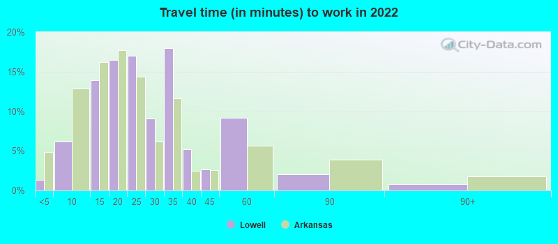
- Mean travel time to work (commute): 18.5 minutes
| Here: | 16.0 |
| Arkansas average: | 11.4 |
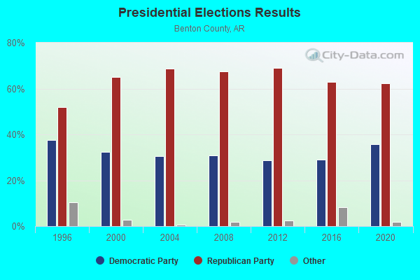
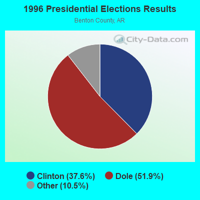
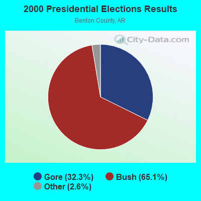
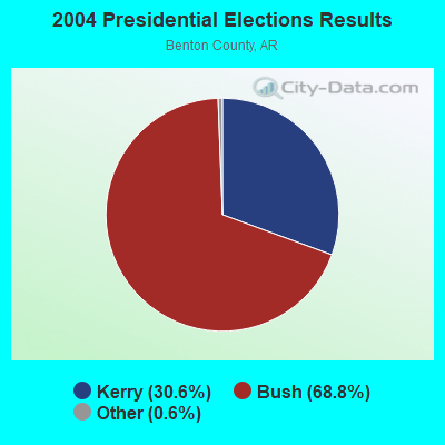


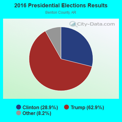
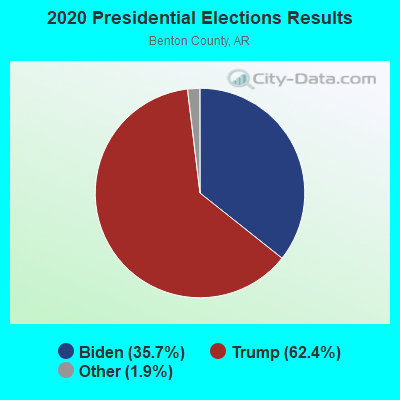
Graphs represent county-level data. Detailed 2008 Election Results
Neighborhoods in Lowell:
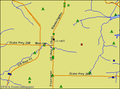
(Lowell, Arkansas Neighborhood Map)- Apple Blossom Industrial Park neighborhood
- Barrett Place neighborhood
- Billie Acres neighborhood
- Bloomington neighborhood
- Blueberry Hill neighborhood
- Borghese neighborhood
- Brentwood neighborhood
- Brookhaven neighborhood
- Buena Vista Harbor Estates neighborhood
- Buffalo Shadows neighborhood
- Cambridge Place neighborhood
- Carrington Parke neighborhood
- Center Ridge Manor neighborhood
- Centerpoint Park (Center Point Park) neighborhood
- Collins Corner neighborhood
- Commerce Center neighborhood
- Commerce Park neighborhood
- Concord Place neighborhood
- Cooper Heights neighborhood
- Country Manor neighborhood
- Cross Creek neighborhood
- Eden's Bluff Estates neighborhood
- Edens Bluff Lake Estates neighborhood
- Edens Estates neighborhood
- Edgehill Manor neighborhood
- Evergreen neighborhood
- Firebird Industrial Park neighborhood
- Ford's Rock Landing neighborhood
- Fox Run neighborhood
- Franklin Terrace neighborhood
- Frisco Springs neighborhood
- Fullerton Park neighborhood
- Golden Oaks neighborhood
- Gram-B Point neighborhood
- Greene Acres neighborhood
- Hickory Heights neighborhood
- Hickory Lake View Estates neighborhood
- Highland Estates neighborhood
- Highland Meadows neighborhood
- Honeysuckle neighborhood
- Kelly Lane neighborhood
- Kendrick Place neighborhood
- Lake Shore Farms at Nelson Hollow neighborhood
- Lakeshore Farms at Nelson Hollow neighborhood
- Lakeview Acres neighborhood
- Lakewood neighborhood
- Lazy R Ranch neighborhood
- Little Hickory Meadows neighborhood
- Lowell Commercial neighborhood
- Lowell Estates neighborhood
- Lowell Industrial Park neighborhood
- Lowell Original neighborhood
- Lowell South Commercial Park neighborhood
- Lynn Estates. neighborhood
- Meadowlands neighborhood
- Meadowlark neighborhood
- Monroe Corner neighborhood
- Mountain Springs Estates neighborhood
- Mountain View neighborhood
- North Hickory Hills neighborhood
- Northridge Heights neighborhood
- Oak Park neighborhood
- Old Homestead neighborhood
- Old Wire Acres neighborhood
- Overland Square neighborhood
- Overman Acres neighborhood
- Park Central neighborhood
- Phillips Acres neighborhood
- Phillips Creek neighborhood
- Pleasant Crossing neighborhood
- Pleasure Heights neighborhood
- Prairie Meadows neighborhood
- Riggins Lake neighborhood
- Sabre Heights neighborhood
- Sand Springs neighborhood
- Sanderson Acres neighborhood
- Shouthfork neighborhood
- South Mountain Estates neighborhood
- Southfork neighborhood
- Southview neighborhood
- Summer Meadows neighborhood
- Summerfield neighborhood
- Sunrise Manor neighborhood
- Sycamore Hill neighborhood
- Sylvan Acres neighborhood
- The Vineyards neighborhood
- Van's Lakeside Acres neighborhood
- Weatherton neighborhood
- Wilkins Estates neighborhood
Religion statistics for Lowell, AR (based on Benton County data)
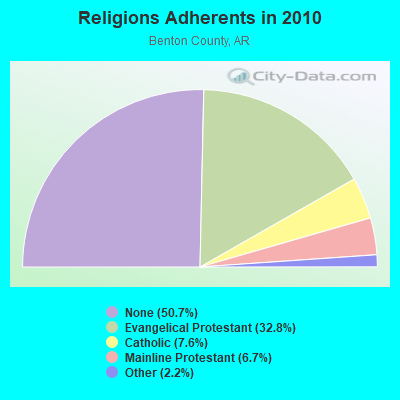
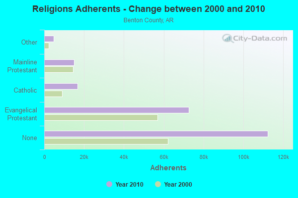
| Religion | Adherents | Congregations |
|---|---|---|
| Evangelical Protestant | 72,566 | 228 |
| Catholic | 16,757 | 4 |
| Mainline Protestant | 14,839 | 43 |
| Other | 4,857 | 20 |
| None | 112,320 | - |
Food Environment Statistics:
| Here: | 1.23 / 10,000 pop. |
| Arkansas: | 2.02 / 10,000 pop. |
| Benton County: | 0.30 / 10,000 pop. |
| State: | 0.25 / 10,000 pop. |
| Benton County: | 0.35 / 10,000 pop. |
| Arkansas: | 0.59 / 10,000 pop. |
| Benton County: | 3.90 / 10,000 pop. |
| State: | 4.94 / 10,000 pop. |
| Benton County: | 6.42 / 10,000 pop. |
| State: | 6.66 / 10,000 pop. |
| This county: | 7.9% |
| State: | 9.8% |
| Benton County: | 27.0% |
| State: | 29.1% |
| Benton County: | 15.4% |
| State: | 13.6% |
Health and Nutrition:
| Here: | 46.3% |
| State: | 48.2% |
| This city: | 42.4% |
| State: | 44.2% |
| Lowell: | 28.6 |
| Arkansas: | 28.9 |
| Lowell: | 21.2% |
| State: | 21.6% |
| Here: | 10.3% |
| Arkansas: | 11.3% |
| Lowell: | 6.7 |
| Arkansas: | 6.8 |
| This city: | 29.8% |
| Arkansas: | 34.0% |
| This city: | 56.2% |
| Arkansas: | 54.4% |
| Lowell: | 80.8% |
| Arkansas: | 78.0% |
More about Health and Nutrition of Lowell, AR Residents
| Local government employment and payroll (March 2022) | |||||
| Function | Full-time employees | Monthly full-time payroll | Average yearly full-time wage | Part-time employees | Monthly part-time payroll |
|---|---|---|---|---|---|
| Firefighters | 25 | $123,291 | $59,180 | 0 | $0 |
| Police Protection - Officers | 21 | $78,456 | $44,832 | 3 | $92 |
| Police - Other | 8 | $33,280 | $49,920 | 0 | $0 |
| Streets and Highways | 8 | $21,969 | $32,954 | 0 | $0 |
| Fire - Other | 4 | $30,044 | $90,132 | 0 | $0 |
| Other Government Administration | 4 | $28,257 | $84,771 | 16 | $3,750 |
| Other and Unallocable | 3 | $15,936 | $63,744 | 0 | $0 |
| Sewerage | 2 | $7,429 | $44,574 | 0 | $0 |
| Health | 2 | $3,895 | $23,370 | 0 | $0 |
| Judicial and Legal | 2 | $7,118 | $42,708 | 0 | $0 |
| Parks and Recreation | 2 | $4,674 | $28,044 | 0 | $0 |
| Financial Administration | 2 | $8,686 | $52,116 | 0 | $0 |
| Totals for Government | 83 | $363,037 | $52,487 | 19 | $3,842 |
Lowell government finances - Expenditure in 2017 (per resident):
- Current Operations - Police Protection: $1,679,000 ($151.95)
Regular Highways: $1,652,000 ($149.50)
Central Staff Services: $1,350,000 ($122.17)
Local Fire Protection: $1,078,000 ($97.56)
Parks and Recreation: $110,000 ($9.95)
Judicial and Legal Services: $14,000 ($1.27)
- General - Interest on Debt: $227,000 ($20.54)
- Total Salaries and Wages: $2,326,000 ($210.50)
Lowell government finances - Revenue in 2017 (per resident):
- Charges - Other: $25,000 ($2.26)
- Federal Intergovernmental - Other: $19,000 ($1.72)
General Local Government Support: $15,000 ($1.36)
Highways: $14,000 ($1.27)
- Local Intergovernmental - General Local Government Support: $1,085,000 ($98.19)
- Miscellaneous - Fines and Forfeits: $521,000 ($47.15)
General Revenue - Other: $181,000 ($16.38)
Interest Earnings: $37,000 ($3.35)
- State Intergovernmental - Highways: $359,000 ($32.49)
Other: $131,000 ($11.86)
General Local Government Support: $124,000 ($11.22)
- Tax - General Sales and Gross Receipts: $2,763,000 ($250.05)
Property: $1,356,000 ($122.71)
Public Utilities Sales: $471,000 ($42.62)
Other License: $171,000 ($15.48)
Lowell government finances - Debt in 2017 (per resident):
- Long Term Debt - Beginning Outstanding - Unspecified Public Purpose: $5,415,000 ($490.05)
Outstanding Unspecified Public Purpose: $5,330,000 ($482.35)
Retired Unspecified Public Purpose: $85,000 ($7.69)
Lowell government finances - Cash and Securities in 2017 (per resident):
- Bond Funds - Cash and Securities: $410,000 ($37.10)
- Other Funds - Cash and Securities: $6,315,000 ($571.49)
- Sinking Funds - Cash and Securities: $915,000 ($82.81)
| Businesses in Lowell, AR | ||||
| Name | Count | Name | Count | |
|---|---|---|---|---|
| AT&T | 1 | McDonald's | 1 | |
| Arby's | 1 | Penske | 2 | |
| AutoZone | 1 | Pizza Hut | 1 | |
| Cricket Wireless | 1 | Quiznos | 1 | |
| Dairy Queen | 1 | Ramada | 1 | |
| Domino's Pizza | 1 | SONIC Drive-In | 1 | |
| FedEx | 5 | Subway | 1 | |
| H&R Block | 1 | Taco Bell | 1 | |
| KFC | 1 | UPS | 1 | |
| Long John Silver's | 1 | World Gym | 1 | |
Strongest AM radio stations in Lowell:
- KURM (790 AM; 5 kW; ROGERS, AR; Owner: KERM, INC)
- KZRA (1590 AM; 2 kW; SPRINGDALE, AR; Owner: CUMULUS LICENSING CORP.)
- KFAY (1030 AM; 10 kW; FARMINGTON, AR; Owner: CUMULUS LICENSING CORP)
- KREB (1190 AM; daytime; 2 kW; BENTONVILLE/BELLA VI, AR; Owner: BUTLER BROADCASTING COMPANY, LLC)
- KZAR (1390 AM; 1 kW; ROGERS, AR; Owner: BUTLER BROADCASTING COMPANY, LLC)
- KUOA (1290 AM; 5 kW; SILOAM SPRINGS, AR; Owner: KUOA, INC.)
- KFAQ (1170 AM; 50 kW; TULSA, OK; Owner: JOURNAL BROADCAST CORPORATION)
- KRMG (740 AM; 50 kW; TULSA, OK; Owner: CXR HOLDINGS, INC.)
- KBTN (1420 AM; 10 kW; NEOSHO, MO; Owner: PETRACOM OF JOPLIN, L.L.C.)
- KTHS (1480 AM; 5 kW; BERRYVILLE, AR; Owner: KTHS/KSCC, INC.)
- KOFC (1250 AM; 1 kW; FAYETTEVILLE, AR; Owner: WILLIAM B. DISNEY & MARTHA J. DISNEY)
- KGHT (880 AM; 50 kW; SHERIDAN, AR; Owner: METROPOLITAN RADIO GROUP, INC.)
- KYHN (1320 AM; 10 kW; FORT SMITH, AR; Owner: CAPSTAR TX LIMITED PARTNERSHIP)
Strongest FM radio stations in Lowell:
- KSEC (95.7 FM; BENTONVILLE, AR; Owner: BENTONVILLE BROADCASTING, LLC)
- K203CE (88.5 FM; SPRINGDALE, AR; Owner: BIBLE BROADCASTING NETWORK, INC.)
- KXNA (104.9 FM; SPRINGDALE, AR; Owner: BUTLER BROADCASTING COMPANY, LLC)
- KMCK-FM (105.7 FM; SILOAM SPRINGS, AR; Owner: CUMULUS LICENSING CORP.)
- KFAY-FM (98.3 FM; BENTONVILLE, AR; Owner: CUMULUS LICENSING CORP)
- KAMO-FM (94.3 FM; ROGERS, AR; Owner: CUMULUS LICENSING CORP.)
- KKEG (92.1 FM; FAYETTEVILLE, AR; Owner: CUMULUS LICENSING CORP)
- KMXF (101.9 FM; LOWELL, AR; Owner: CAPSTAR TX LIMITED PARTNERSHIP)
- KBNV (90.1 FM; FAYETTEVILLE, AR; Owner: AMERICAN FAMILY ASSOCIATION)
- KIGL (93.3 FM; SELIGMAN, MO; Owner: CAPSTAR TX LIMITED PARTNERSHIP)
- KEZA (107.9 FM; FAYETTEVILLE, AR; Owner: CAPSTAR TX LIMITED PARTNERSHIP)
- KAYH (89.3 FM; FAYETTEVILLE, AR; Owner: FAMILY VISION MINISTRIES, INC.)
- K244DS (96.7 FM; FAYETTEVILLE, AR; Owner: BUTLER BROADCASTING COMPANY, LLC)
- KUAF (91.3 FM; FAYETTEVILLE, AR; Owner: BOARD OF TRUSTEES OF THE UNIVERSITY OF ARKANSAS)
- KBVA (106.5 FM; BELLA VISTA, AR; Owner: GAYLA JOY HENDREN)
- KAPG (88.1 FM; BENTONVILLE, AR; Owner: AMERICAN FAMILY ASSOCIATION)
- KKIX (103.9 FM; FAYETTEVILLE, AR; Owner: CAPSTAR TX LIMITED PARTNERSHIP)
- K272DQ (102.3 FM; FAYETTEVILLE, AR; Owner: CAPSTAR TX LIMITED PARTNERSHIP)
- KREB-FM (99.5 FM; HUNTSVILLE, AR; Owner: BUTLER BROADCASTING COMPANY, LLC)
- KXUA (88.3 FM; FAYETTEVILLE, AR; Owner: BRD. OF TRUST. OF UNIV. OF ARKANSAS)
TV broadcast stations around Lowell:
- KFAA (Channel 51; ROGERS, AR; Owner: J.D.G. TELEVISION, INC.)
- K62DQ (Channel 62; FAYETTEVILLE, ETC., AR; Owner: NEW YORK TIMES MANAGEMENT SERVICES)
- K64FO (Channel 64; FAYETTEVILLE, AR; Owner: FORT SMITH 46, INC.)
- KVAQ-LP (Channel 20; SPRINGDALE, AR; Owner: CHRISTIANS INCORPORATED FOR CHRIST)
- K15DR (Channel 15; SPRINGDALE, AR; Owner: FORT SMITH 46, INC.)
- K59ES (Channel 59; HINDSVILLE, AR; Owner: FORT SMITH 46, INC.)
- K67EO (Channel 67; BENTONVILLE, AR; Owner: NEW YORK TIMES MANAGEMENT SERVICES)
- K14IT (Channel 14; BENTONVILLE, AR; Owner: FORT SMITH 46, INC.)
- KSBN-TV (Channel 57; SPRINGDALE, AR; Owner: TOTAL LIFE COMMUNITY EDUCATIONAL FOUNDATION)
- KHOG-TV (Channel 29; FAYETTEVILLE, AR; Owner: KHBS HEARST-ARGYLE TELEVISION, INC.)
- KFFS-CA (Channel 36; FAYETTEVILLE, AR; Owner: FORT SMITH 46, INC.)
- KAFT (Channel 13; FAYETTEVILLE, AR; Owner: ARKANSAS EDUCATIONAL TELEVISION COMMISSION)
- KWBS-TV (Channel 34; EUREKA SPRINGS, AR; Owner: TV 34, INC.)
- K45EI (Channel 45; BENTONVILLE & ROGERS, AR; Owner: VICTORY COMMUNICATIONS, INC.)
- KNJE-LP (Channel 68; EUREKA SPRINGS, AR; Owner: TV-34, INC., AN ARKANSAS CORPORATION)
- K42BS (Channel 42; FAYETTEVILLE, AR; Owner: TRINITY BROADCASTING NETWORK)
- K33FG (Channel 33; SILOAM SPRINGS, AR; Owner: FORT SMITH 46, INC.)
- National Bridge Inventory (NBI) Statistics
- 34Number of bridges
- 312ft / 94.7mTotal length
- 821,079Total average daily traffic
- 69,954Total average daily truck traffic
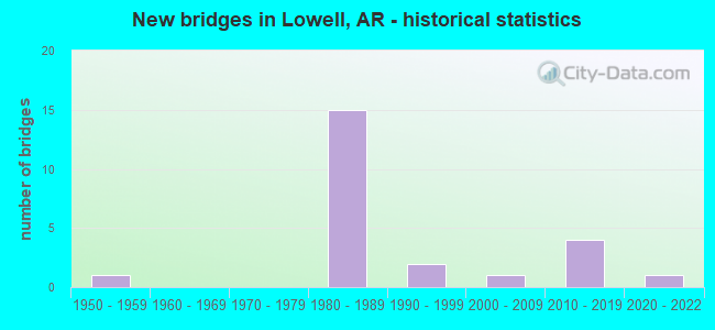
- New bridges - historical statistics
- 11950-1959
- 151980-1989
- 21990-1999
- 12000-2009
- 42010-2019
- 12020-2022
FCC Registered Antenna Towers:
57 (See the full list of FCC Registered Antenna Towers in Lowell)FCC Registered Broadcast Land Mobile Towers:
1- Lat: 36.226750 Lon: -94.181167, Call Sign: WQWY610,
Assigned Frequencies: 461.200 MHz, 464.050 MHz, 464.400 MHz, 466.200 MHz, 469.050 MHz, Grant Date: 12/29/2015, Expiration Date: 12/29/2025, Certifier: Brandon Lefevre, Registrant: Radiophone Of N.W. Ar Inc., 207 E. Monroe, Ste A, Lowell, AR 72745, Phone: (479) 751-3730, Email:
FCC Registered Microwave Towers:
1- LR03SW460, 13520 Alto Road (Lat: 36.224250 Lon: -94.055333), Type: Gtower, Structure height: 99 m, Overall height: 103.6 m, Call Sign: WQSF850,
Assigned Frequencies: 11585.0 MHz, 11585.0 MHz, 11585.0 MHz, 11585.0 MHz, 11585.0 MHz, 11585.0 MHz, Grant Date: 09/16/2013, Expiration Date: 09/16/2023, Cancellation Date: 09/14/2023, Certifier: David Werblow, Registrant: T-Mobile Usa, Inc., 12920 Se 38th Street, Bellevue, WA 98006, Phone: (425) 383-8401, Email:
FCC Registered Amateur Radio Licenses:
60 (See the full list of FCC Registered Amateur Radio Licenses in Lowell)FAA Registered Aircraft Manufacturers and Dealers:
2 (See the full list of FAA Registered Manufacturers and Dealers in Lowell)FAA Registered Aircraft:
14 (See the full list of FAA Registered Aircraft)| Home Mortgage Disclosure Act Aggregated Statistics For Year 1999 (Based on 1 partial tract) | ||||||||||
| A) FHA, FSA/RHS & VA Home Purchase Loans | B) Conventional Home Purchase Loans | C) Refinancings | D) Home Improvement Loans | F) Non-occupant Loans on < 5 Family Dwellings (A B C & D) | ||||||
|---|---|---|---|---|---|---|---|---|---|---|
| Number | Average Value | Number | Average Value | Number | Average Value | Number | Average Value | Number | Average Value | |
| LOANS ORIGINATED | 6 | $77,882 | 14 | $118,035 | 14 | $112,699 | 3 | $14,433 | 3 | $60,450 |
| APPLICATIONS APPROVED, NOT ACCEPTED | 0 | $0 | 2 | $43,300 | 1 | $81,500 | 0 | $0 | 0 | $0 |
| APPLICATIONS DENIED | 0 | $0 | 3 | $59,147 | 3 | $80,033 | 1 | $11,890 | 0 | $0 |
| APPLICATIONS WITHDRAWN | 1 | $56,030 | 1 | $79,980 | 2 | $101,030 | 1 | $16,130 | 0 | $0 |
| FILES CLOSED FOR INCOMPLETENESS | 0 | $0 | 0 | $0 | 1 | $47,880 | 0 | $0 | 0 | $0 |
| Private Mortgage Insurance Companies Aggregated Statistics For Year 1999 (Based on 1 partial tract) | ||||
| A) Conventional Home Purchase Loans | B) Refinancings | |||
|---|---|---|---|---|
| Number | Average Value | Number | Average Value | |
| LOANS ORIGINATED | 3 | $131,200 | 2 | $151,290 |
| APPLICATIONS APPROVED, NOT ACCEPTED | 1 | $140,420 | 0 | $0 |
| APPLICATIONS DENIED | 0 | $0 | 0 | $0 |
| APPLICATIONS WITHDRAWN | 0 | $0 | 0 | $0 |
| FILES CLOSED FOR INCOMPLETENESS | 0 | $0 | 0 | $0 |
2002 - 2018 National Fire Incident Reporting System (NFIRS) incidents
- Fire incident types reported to NFIRS in Lowell, AR
- 84253.5%Outside Fires
- 53333.8%Structure Fires
- 18311.6%Mobile Property/Vehicle Fires
- 171.1%Other
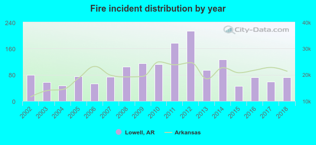 According to the data from the years 2002 - 2018 the average number of fire incidents per year is 93. The highest number of fires - 214 took place in 2012, and the least - 45 in 2015. The data has a decreasing trend.
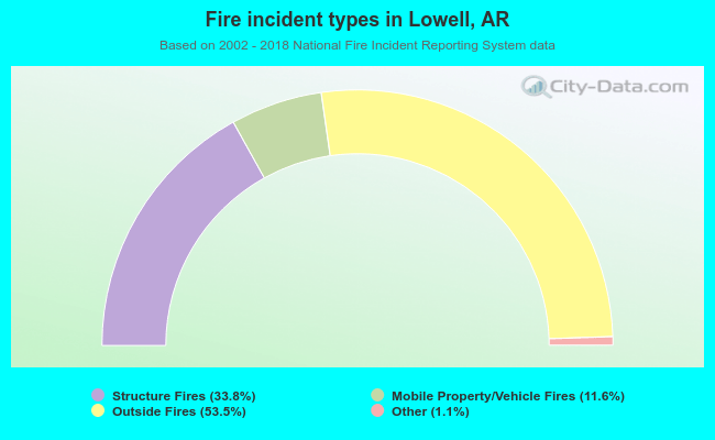 When looking into fire subcategories, the most incidents belonged to: Outside Fires (53.5%), and Structure Fires (33.8%).
| Most common first names in Lowell, AR among deceased individuals | ||
| Name | Count | Lived (average) |
|---|---|---|
| William | 31 | 74.5 years |
| James | 29 | 66.9 years |
| John | 21 | 78.8 years |
| Mary | 21 | 77.2 years |
| Charles | 18 | 71.4 years |
| Robert | 17 | 67.8 years |
| Roy | 15 | 68.6 years |
| Richard | 12 | 67.4 years |
| Joseph | 11 | 77.5 years |
| Helen | 10 | 81.8 years |
| Most common last names in Lowell, AR among deceased individuals | ||
| Last name | Count | Lived (average) |
|---|---|---|
| Smith | 19 | 70.7 years |
| Mcgarrah | 18 | 77.5 years |
| Jones | 16 | 76.9 years |
| Neil | 15 | 78.8 years |
| Baker | 12 | 67.4 years |
| Main | 11 | 72.5 years |
| Brown | 11 | 70.1 years |
| Graham | 10 | 75.8 years |
| Williams | 10 | 78.7 years |
| Kendrick | 9 | 73.0 years |
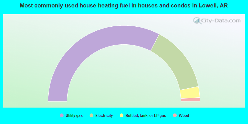
- 65.4%Utility gas
- 28.3%Electricity
- 4.7%Bottled, tank, or LP gas
- 1.6%Wood
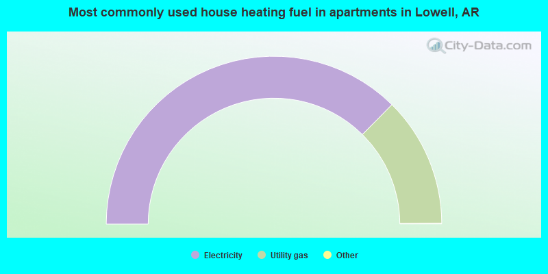
- 74.9%Electricity
- 25.1%Utility gas
Lowell compared to Arkansas state average:
- Median household income above state average.
- Median house value above state average.
- Unemployed percentage significantly below state average.
- Black race population percentage significantly below state average.
- Hispanic race population percentage significantly above state average.
- Median age below state average.
- Foreign-born population percentage significantly above state average.
- Length of stay since moving in significantly above state average.
- House age significantly below state average.
Lowell on our top lists:
- #32 on the list of "Top 101 cities with the largest percentage of divorced people (15+ years)(population 5,000+)"
- #24 on the list of "Top 101 counties with the largest number of people moving in compared to moving out (pop. 50,000+)"
- #74 on the list of "Top 101 counties with the lowest average weight of females"
- #75 on the list of "Top 101 counties with the highest percentage of residents that drank alcohol in the past 30 days"
- #95 on the list of "Top 101 counties with the lowest percentage of residents that visited a dentist within the past year"
- #101 on the list of "Top 101 counties with the lowest percentage of residents that exercised in the past month"

|
|
Total of 23 patent applications in 2008-2024.