Donner, California
Submit your own pictures of this place and show them to the world
- OSM Map
- General Map
- Google Map
- MSN Map

| Males: 8,027 | |
| Females: 7,160 |
| Median resident age: | 35.5 years |
| California median age: | 33.3 years |
Zip code: 96161
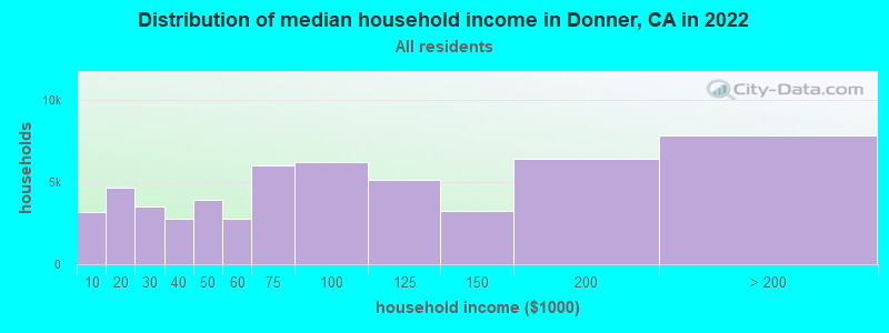
| Donner: | $99,437 |
| CA: | $91,551 |
Estimated per capita income in 2022: $55,755 (it was $26,735 in 2000)
Donner CCD income, earnings, and wages data
Estimated median house or condo value in 2022: $761,676 (it was $239,700 in 2000)
| Donner: | $761,676 |
| CA: | $715,900 |
Mean prices in 2022: all housing units: $671,783; detached houses: $711,962; townhouses or other attached units: $562,684; in 2-unit structures: $635,120; in 3-to-4-unit structures: $473,525; in 5-or-more-unit structures: $477,291; mobile homes: $148,863; occupied boats, rvs, vans, etc.: $264,050
Detailed information about poverty and poor residents in Donner, CA


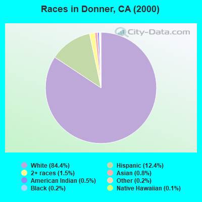
- 12,22684.4%White alone
- 1,79312.4%Hispanic
- 2141.5%Two or more races
- 1160.8%Asian alone
- 670.5%American Indian alone
- 270.2%Black alone
- 290.2%Other race alone
- 200.1%Native Hawaiian and Other
Pacific Islander alone
 Recent articles from our blog. Our writers, many of them Ph.D. graduates or candidates, create easy-to-read articles on a wide variety of topics.
Current Local Time: PST time zone
Elevation: 7020 feet
Land area: 342.7 square miles.
Population density: 44 people per square mile (very low).

| Donner CCD: | 0.8% ($1,871) |
| California: | 0.8% ($1,564) |
Nearest city with pop. 50,000+: Reno, NV  (26.7 miles , pop. 180,480).
Nearest city with pop. 200,000+: Sacramento, CA (85.1 miles , pop. 407,018).
Nearest city with pop. 1,000,000+: Los Angeles, CA (379.9 miles , pop. 3,694,820).
Nearest cities:
), Latitude: 39.36 N, Longitude: 120.27 W
Area code commonly used in this area: 530

| Here: | 4.2% |
| California: | 5.1% |
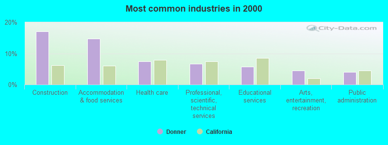
- Construction (17.1%)
- Accommodation & food services (14.7%)
- Health care (7.5%)
- Professional, scientific, technical services (6.7%)
- Educational services (5.8%)
- Arts, entertainment, recreation (4.5%)
- Public administration (4.0%)
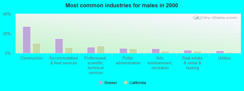
- Construction (27.1%)
- Accommodation & food services (15.0%)
- Professional, scientific, technical services (6.2%)
- Public administration (5.0%)
- Arts, entertainment, recreation (4.8%)
- Real estate & rental & leasing (3.2%)
- Utilities (2.6%)
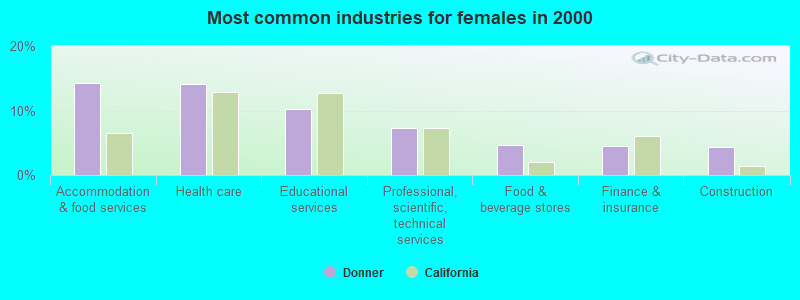
- Accommodation & food services (14.2%)
- Health care (14.1%)
- Educational services (10.2%)
- Professional, scientific, technical services (7.2%)
- Food & beverage stores (4.6%)
- Finance & insurance (4.4%)
- Construction (4.3%)
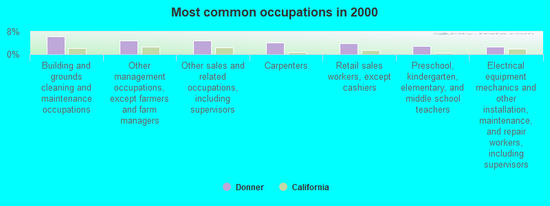
- Building and grounds cleaning and maintenance occupations (6.2%)
- Other management occupations, except farmers and farm managers (5.0%)
- Other sales and related occupations, including supervisors (4.8%)
- Carpenters (4.2%)
- Retail sales workers, except cashiers (3.9%)
- Preschool, kindergarten, elementary, and middle school teachers (3.0%)
- Electrical equipment mechanics and other installation, maintenance, and repair workers, including supervisors (2.6%)
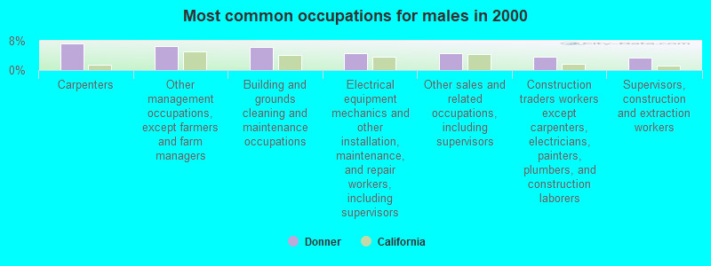
- Carpenters (7.3%)
- Other management occupations, except farmers and farm managers (6.7%)
- Building and grounds cleaning and maintenance occupations (6.3%)
- Electrical equipment mechanics and other installation, maintenance, and repair workers, including supervisors (4.6%)
- Other sales and related occupations, including supervisors (4.6%)
- Construction traders workers except carpenters, electricians, painters, plumbers, and construction laborers (3.6%)
- Supervisors, construction and extraction workers (3.3%)
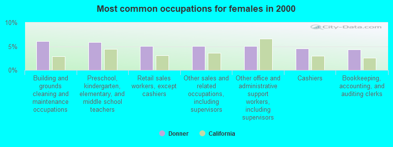
- Building and grounds cleaning and maintenance occupations (6.1%)
- Preschool, kindergarten, elementary, and middle school teachers (5.8%)
- Retail sales workers, except cashiers (5.1%)
- Other sales and related occupations, including supervisors (5.1%)
- Other office and administrative support workers, including supervisors (5.0%)
- Cashiers (4.5%)
- Bookkeeping, accounting, and auditing clerks (4.4%)
Average climate in Donner, California
Based on data reported by over 4,000 weather stations


(lower is better)
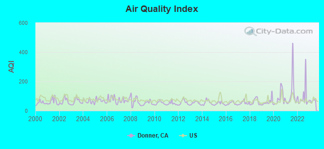
Air Quality Index (AQI) level in 2023 was 68.0. This is about average.
| City: | 68.0 |
| U.S.: | 72.6 |
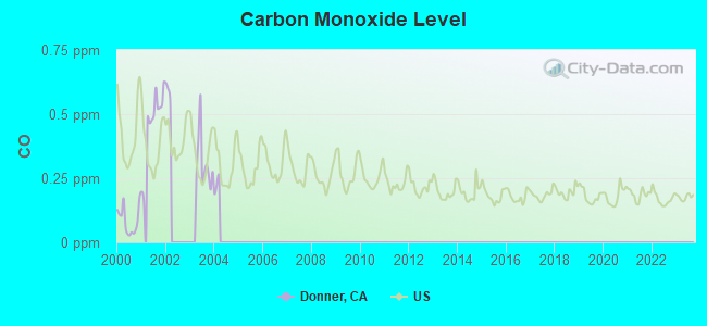
Carbon Monoxide (CO) [ppm] level in 2003 was 0.310. This is worse than average. Closest monitor was 5.4 miles away from the city center.
| City: | 0.310 |
| U.S.: | 0.251 |
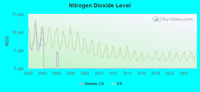
Nitrogen Dioxide (NO2) [ppb] level in 2001 was 7.42. This is significantly worse than average. Closest monitor was 14.9 miles away from the city center.
| City: | 7.42 |
| U.S.: | 5.11 |
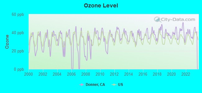
Ozone [ppb] level in 2023 was 41.6. This is worse than average. Closest monitor was 5.4 miles away from the city center.
| City: | 41.6 |
| U.S.: | 33.3 |
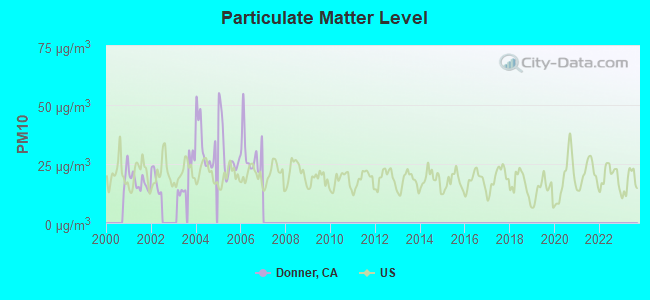
Particulate Matter (PM10) [µg/m3] level in 2006 was 29.3. This is significantly worse than average. Closest monitor was 5.4 miles away from the city center.
| City: | 29.3 |
| U.S.: | 19.2 |
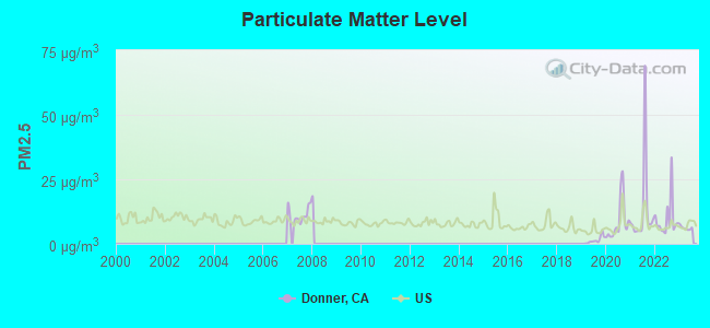
Particulate Matter (PM2.5) [µg/m3] level in 2023 was 6.16. This is better than average. Closest monitor was 5.4 miles away from the city center.
| City: | 6.16 |
| U.S.: | 8.11 |
Earthquake activity:
Donner-area historical earthquake activity is significantly above California state average. It is 7022% greater than the overall U.S. average.Natural disasters:
The number of natural disasters in Nevada County (16) is near the US average (15).Major Disasters (Presidential) Declared: 8
Emergencies Declared: 2
Causes of natural disasters: Floods: 9, Fires: 4, Landslides: 4, Mudslides: 4, Storms: 4, Winter Storms: 4, Drought: 1, Heavy Rain: 1, Hurricane: 1, Other: 1 (Note: some incidents may be assigned to more than one category).
Amtrak stations near Donner:
- 6 miles: TRUCKEE (RAILROAD ST. & COMMERCIAL ROW) . Services: fully wheelchair accessible, enclosed waiting area, public payphones, free short-term parking, free long-term parking, car rental agency, call for taxi service.
- 6 miles: SODA SPRINGS (DONNER SUMMIT LODGE) - Bus Station . Services: fully wheelchair accessible, public payphones, full-service food facilities, free short-term parking, free long-term parking.
Colleges/universities with over 2000 students nearest to Donner:
- University of Nevada-Reno (about 28 miles; Reno, NV; Full-time enrollment: 15,092)
- Western Nevada College (about 29 miles; Carson City, NV; FT enrollment: 2,338)
- Truckee Meadows Community College (about 30 miles; Reno, NV; FT enrollment: 6,919)
- Sierra College (about 65 miles; Rocklin, CA; FT enrollment: 11,488)
- Folsom Lake College (about 67 miles; Folsom, CA; FT enrollment: 5,308)
- Yuba College (about 70 miles; Marysville, CA; FT enrollment: 4,737)
- Butte College (about 76 miles; Oroville, CA; FT enrollment: 8,649)
Points of interest:
Notable locations in Donner: Buttes Area Camp (A), Camp Pahatsi (B), Cold Springs Campground (C), Van Norden Campground (D), Upper Alder Creek Picnic Area (E), Splitrock Campground (F), Ridge Campground (G), Ponderosa Golf Course (H), Jim McIvers Memorial Arena (I), Creek Campground (J), Farad Powerhouse (K), Deer Park Recreation Site (L), Donner Summit Recreation Site (M), Soda Springs Ski Area (N), Sagehen Creek Campground (O), English Mountain Ranch (P), Indian Springs Campground (Q), Tahoe Donner Ski Area (R), Donner Summit Ski Area (S), Boreal Ridge Ski Area (T). Display/hide their locations on the map
Cemetery: Truckee Cemetery (1). Display/hide its location on the map
Lakes and reservoirs: Summit Lake (A), Catfish Lake (B), Lily Pond (C), Warren Lake (D), Wagon Wheel Lake (E), Beyers Lakes (F), Flora Lake (G), Faucherie Lake (H). Display/hide their locations on the map
Rivers and creeks: Cold Creek (A), Lower Castle Creek (B), North Creek (C), Subterranean Creek (D), Upper Independence Creek (E), Prosser Creek (F), Toms Creek (G), South Fork Canyon Creek (H), Little Truckee River (I). Display/hide their locations on the map
Parks in Donner include: Truckee River Regional Park (1), West End Beach Park (2), Donner Memorial State Park (3), Donner Monument (4). Display/hide their locations on the map
| This place: | 2.5 people |
| California: | 2.9 people |
| This place: | 65.2% |
| Whole state: | 68.7% |
| This place: | 8.8% |
| Whole state: | 7.2% |
Likely homosexual households (counted as self-reported same-sex unmarried-partner households)
- Lesbian couples: 0.5% of all households
- Gay men: 0.2% of all households
| This place: | 4.7% |
| Whole state: | 14.2% |
| This place: | 1.6% |
| Whole state: | 6.3% |
16 people in workers' group living quarters and job corps centers in 2010
People in group quarters in Donner in 2000:
- 33 people in hospitals/wards and hospices for chronically ill
- 33 people in other hospitals or wards for chronically ill
- 10 people in other workers' dormitories
- 3 people in other noninstitutional group quarters
For population 15 years and over in Donner:
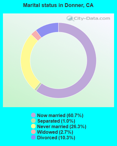
- Never married: 26.3%
- Now married: 60.7%
- Separated: 1.0%
- Widowed: 2.7%
- Divorced: 10.3%
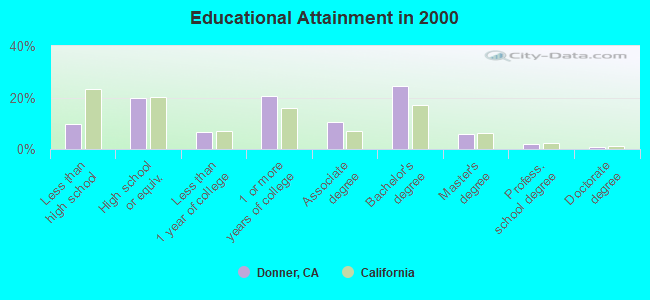
For population 25 years and over in Donner:
- High school or higher: 90.2%
- Bachelor's degree or higher: 32.6%
- Graduate or professional degree: 8.3%
- Unemployed: 3.7%
- Mean travel time to work (commute): 21.5 minutes
| Here: | 9.7 |
| California average: | 16.1 |
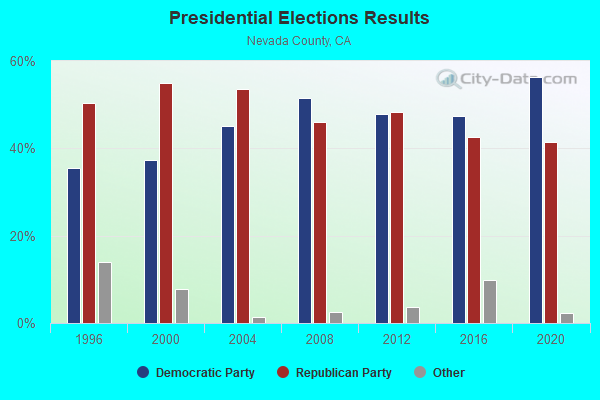
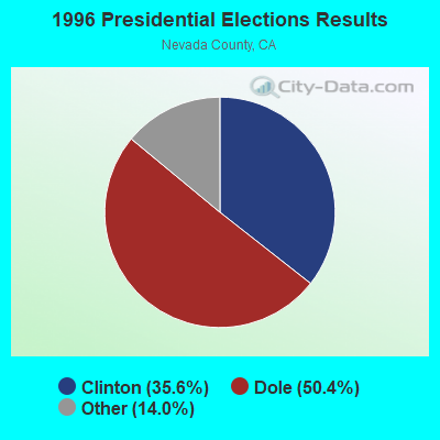
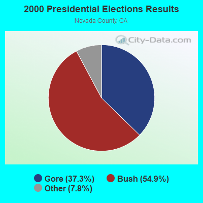
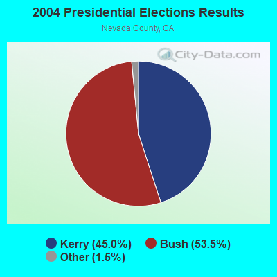
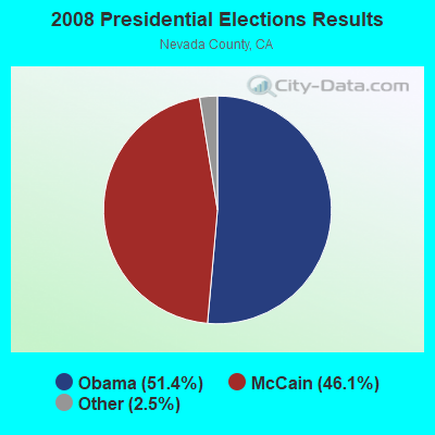

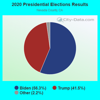
Graphs represent county-level data. Detailed 2008 Election Results
Religion statistics for Donner, CA (based on Nevada County data)
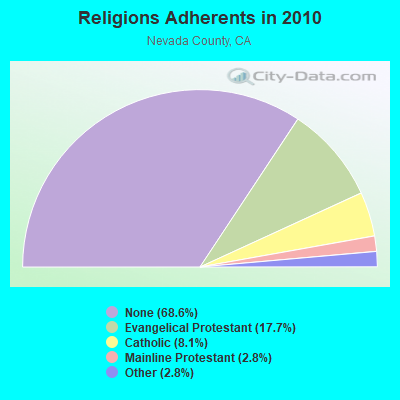
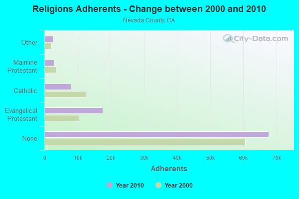
| Religion | Adherents | Congregations |
|---|---|---|
| Evangelical Protestant | 17,527 | 45 |
| Catholic | 7,999 | 4 |
| Mainline Protestant | 2,795 | 12 |
| Other | 2,732 | 26 |
| None | 67,711 | - |
Food Environment Statistics:
| Nevada County: | 2.58 / 10,000 pop. |
| California: | 2.14 / 10,000 pop. |
| This county: | 0.93 / 10,000 pop. |
| California: | 0.62 / 10,000 pop. |
| Nevada County: | 1.65 / 10,000 pop. |
| State: | 1.49 / 10,000 pop. |
| This county: | 10.12 / 10,000 pop. |
| California: | 7.42 / 10,000 pop. |
| This county: | 7.1% |
| State: | 7.3% |
| Nevada County: | 20.5% |
| California: | 21.3% |
| Nevada County: | 13.5% |
| State: | 17.9% |
Strongest AM radio stations in Donner:
- KKOH (780 AM; 50 kW; RENO, NV; Owner: CITADEL BROADCASTING COMPANY)
- KPTT (630 AM; 5 kW; RENO, NV; Owner: LOTUS RADIO CORP.)
- KBZZ (1270 AM; 13 kW; SPARKS, NV; Owner: AMERICOM LAS VEGAS LIMITED PARTNERSHIP)
- KFIA (710 AM; 25 kW; CARMICHAEL, CA; Owner: VISTA BROADCASTING INC.)
- KHTK (1140 AM; 50 kW; SACRAMENTO, CA; Owner: INFINITY RADIO SUBSIDIARY OPERATIONS INC.)
- KFBK (1530 AM; 50 kW; SACRAMENTO, CA; Owner: AMFM RADIO LICENSES, L.L.C.)
- KSTE (650 AM; 25 kW; RANCHO CORDOVA, CA; Owner: AMFM RADIO LICENSES, L.L.C.)
- KIHM (920 AM; 5 kW; RENO, NV; Owner: IHR EDUCATIONAL BROADCASTING)
- KCBC (770 AM; 50 kW; RIVERBANK, CA; Owner: KIERTRON, INC.)
- KPTL (1300 AM; 5 kW; CARSON CITY, NV; Owner: CASINO RADIO, LLC)
- KAHI (950 AM; 10 kW; AUBURN, CA; Owner: IHR EDUCATIONAL BROADCASTING)
- KQLO (1590 AM; 5 kW; SUN VALLEY, NV; Owner: THOMAS AQUINAS SCHOOL)
- KNCO (830 AM; 5 kW; GRASS VALLEY, CA; Owner: NEVADA COUNTY BROADCASTERS, INC.)
Strongest FM radio stations in Donner:
- KTKE (101.5 FM; TRUCKEE, CA; Owner: TRUCKSTER BROADCASTING, INC.)
- KRNO (106.9 FM; INCLINE VILLAGE, NV; Owner: AMERICOM LAS VEGAS LIMITED PARTNERSHIP)
- KODS (103.7 FM; CARNELIAN BAY, CA; Owner: AMERICOM, A CALIFORNIA LIMITED PARTNERSHIP)
- KLCA (96.5 FM; TAHOE CITY, CA; Owner: AMERICOM LAS VEGAS LIMITED PARTNERSHIP)
- KKTO (90.5 FM; TAHOE CITY, CA; Owner: CALIFORNIA STATE UNIVERSITY)
- KDOT (104.5 FM; RENO, NV; Owner: LOTUS RADIO CORP.)
- KOZZ-FM (105.7 FM; RENO, NV; Owner: LOTUS RADIO CORP.)
- KTHX-FM (100.1 FM; DAYTON, NV; Owner: NM LICENSING, LLC)
- K285EQ (104.9 FM; VERDI, NV; Owner: AMERICOM, A CALIFORNIA LIMITED PARTNERSHIP)
- KSRN (107.7 FM; KINGS BEACH, CA; Owner: NM LICENSING, LLC)
- KWYL (102.9 FM; SOUTH LAKE TAHOE, CA; Owner: CITADEL BROADCASTING COMPANY)
- KNEV (95.5 FM; RENO, NV; Owner: CITADEL BROADCASTING COMPANY)
- KBUL-FM (98.1 FM; CARSON CITY, NV; Owner: CITADEL BROADCASTING COMPANY)
- KNIS (91.3 FM; CARSON CITY, NV; Owner: WESTERN INSPIRATIONAL BROADCASTERS, INC)
- KUNR (88.7 FM; RENO, NV; Owner: UNIVERSITY OF NEVADA, RENO)
- KWNZ (97.3 FM; CARSON CITY, NV; Owner: AMERICOM LAS VEGAS LIMITED PARTNERSHIP)
- KSSJ (94.7 FM; FAIR OAKS, CA; Owner: ENTERCOM SACRAMENTO LICENSE, LLC)
- K273AF (102.5 FM; CARSON CITY, NV; Owner: EDDIE FLOYD)
- KHXR (94.5 FM; SUN VALLEY, NV; Owner: LOTUS RADIO CORP.)
- K286AG (105.1 FM; CARSON CITY, NV; Owner: NM LICENSING, LLC)
TV broadcast stations around Donner:
- KMMK-LP (Channel 14; SACRAMENTO, CA; Owner: CABALLERO TELEVISION TEXAS, L.L.C.)
FCC Registered Broadcast Land Mobile Towers:
1- TUNNEL 42 MO, Lat: 39.312722 Lon: -120.244722, Call Sign: WRCE923,
Assigned Frequencies: 452.925 MHz, 452.950 MHz, 457.925 MHz, 457.950 MHz, Grant Date: 09/13/2018, Expiration Date: 09/13/2028, Certifier: Thomas J Mcgovern, Registrant: Prokarma, 222 So 15th St. Suite 505n, Omaha, NE 68102, Phone: (402) 522-5068, Fax: (402) 346-6676, Email:
FCC Registered Microwave Towers:
2- DONNER, Donner Microwave Site (Lat: 39.321556 Lon: -120.336306), Type: Tower, Structure height: 10.6 m, Call Sign: WQPJ633,
Assigned Frequencies: 955.550 MHz, Grant Date: 05/24/2022, Expiration Date: 06/06/2032, Certifier: Thomas J Mcgovern, Registrant: Concentrix, 222 S 15th St Suite 505n, Omaha, NE 68102, Phone: (402) 522-5068, Email:
- TUNNEL 41, 50 Ft E Of Norden Signal Cabin (Lat: 39.309417 Lon: -120.337389), Type: Pole, Structure height: 9.1 m, Call Sign: WQPJ634,
Assigned Frequencies: 959.150 MHz, Grant Date: 05/24/2022, Expiration Date: 06/06/2032, Certifier: Thomas J Mcgovern, Registrant: Concentrix, 222 S 15th St Suite 505n, Omaha, NE 68102, Phone: (402) 522-5068, Email:
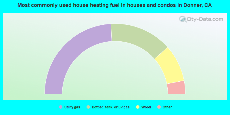
- 48.1%Utility gas
- 28.8%Bottled, tank, or LP gas
- 17.0%Wood
- 3.4%Electricity
- 1.5%Fuel oil, kerosene, etc.
- 0.6%Other fuel
- 0.5%Solar energy
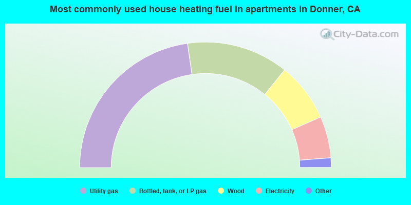
- 45.5%Utility gas
- 26.2%Bottled, tank, or LP gas
- 15.2%Wood
- 10.7%Electricity
- 2.1%Fuel oil, kerosene, etc.
- 0.4%Other fuel
Donner compared to California state average:
- Unemployed percentage significantly below state average.
- Black race population percentage significantly below state average.
- Hispanic race population percentage significantly below state average.
- Foreign-born population percentage significantly below state average.
- Length of stay since moving in significantly above state average.
- Number of rooms per house significantly below state average.
- House age significantly below state average.
Donner on our top lists:
- #9 on the list of "Top 101 cities with largest percentage of males in occupations: carpenters (population 5,000+)"
- #17 on the list of "Top 101 cities with largest percentage of males in industries: sporting goods, camera, and hobby and toy stores (population 5,000+)"
- #21 on the list of "Top 100 highest located cities (pop. 5,000+)"
- #24 on the list of "Top 101 cities with largest percentage of females in occupations: architects, surveyors, and cartographers (population 5,000+)"
- #34 on the list of "Top 101 cities with largest percentage of females in industries: building material and garden equipment and supplies dealers (population 5,000+)"
- #41 on the list of "Top 101 cities with largest percentage of males in industries: apparel, fabrics, and notions merchant wholesalers (population 5,000+)"
- #49 on the list of "Top 101 cities with largest percentage of females in occupations: printing workers (population 5,000+)"
- #51 on the list of "Top 101 cities with largest percentage of males in occupations: supervisors and other personal care and service workers except personal appearance, transportation, and child care workers (population 5,000+)"
- #52 on the list of "Top 101 cities with largest percentage of males in occupations: entertainers and performers, sports, and related workers (population 5,000+)"
- #55 on the list of "Top 101 cities with largest percentage of males in occupations: other food preparation and serving workers including supervisors (population 5,000+)"
- #72 on the list of "Top 101 cities with largest percentage of males in industries: construction (population 5,000+)"
- #81 on the list of "Top 101 cities with largest percentage of females in industries: furniture and home furnishings, and household appliance stores (population 5,000+)"
- #98 on the list of "Top 101 cities with largest percentage of females in industries: fuel dealers (population 5,000+)"
- #12 on the list of "Top 101 counties with the highest Ozone (1-hour) air pollution readings in 2012 (ppm)"
- #30 on the list of "Top 101 counties with the lowest Particulate Matter (PM2.5) Annual air pollution readings in 2012 (µg/m3)"
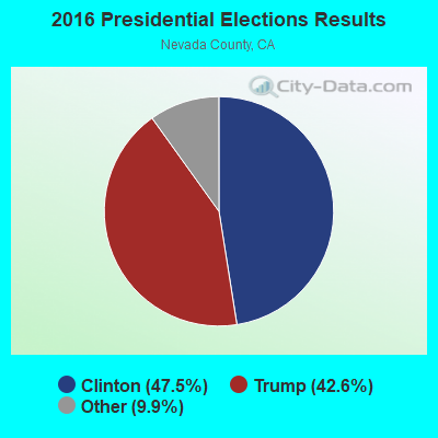
- #47 on the list of "Top 101 counties with highest percentage of residents voting for 3rd party candidates in the 2012 Presidential Election (pop. 50,000+)"