Woodmore neighborhood in Bowie, Maryland (MD), 20721 detailed profile
Settings
X

Business Search - 14 Million verified businesses
Area: 5.640 square miles
Population: 5,888
Population density:
| Woodmore: | 1,044 people per square mile |
| Bowie: | 3,597 people per square mile |

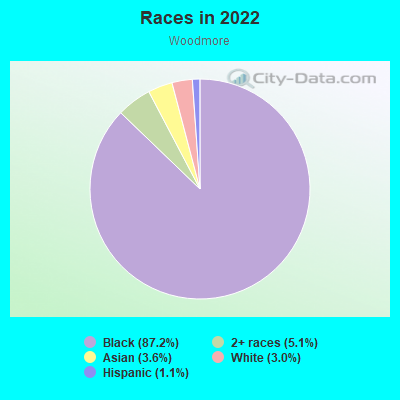
- 5,41087.2%Black
- 3175.1%Two or more races
- 2243.6%Asian
- 1853.0%White
- 671.1%Hispanic or Latino
Median household income in 2022:
| Woodmore: | $138,661 |
| Bowie: | $138,797 |
Distribution of median household income
![Distribution of median household income]()
- 180Less than $10,000
- 53$10,000 to $19,999
- 44$40,000 to $49,999
- 68$50,000 to $59,999
- 385$60,000 to $74,999
- 450$75,000 to $99,999
- 85$100,000 to $124,999
- 417$125,000 to $149,999
- 135$150,000 to $199,999
- 692$200,000 or more

Distribution of owner-occupied house/condo value
![Distribution of owner-occupied house/condo value]()
- 106Less than $50,000
- 68$50,000 to $99,999
- 38$150,000 to $199,999
- 280$200,000 to $249,999
- 615$250,000 to $299,999
- 74$300,000 to $399,999
- 934$400,000 to $499,999
- 602$500,000 to $749,999
- 180$750,000 to $999,999
- 107$1,000,000 or more

Distribution of rent paid by renters
![Distribution of rent paid by renters]()
- 62$1,500 to $1,999
- 105$2,000 or more

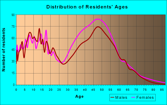
| Males: | 3,183 |
| Females: | 2,705 |
Males:
| This neighborhood: | 62.9 years |
| Whole city: | 40.8 years |
| This neighborhood: | 56.3 years |
| Whole city: | 46.2 years |
Average household size:
| Woodmore: | 2.9 people |
| Bowie: | 2.8 people |
Percentage of family households:
| Woodmore: | 32.5% |
| Bowie: | 51.4% |
| Here: | 59.2% |
| Bowie: | 51.8% |
Percentage of married-couple families with children (among all households):
| Woodmore: | 29.9% |
| Bowie: | 25.9% |
Percentage of single-mother households (among all households):
| Woodmore: | 4.5% |
| Bowie: | 8.6% |
Percentage of never married males 15 years old and over:
Percentage of never married females 15 years old and over:
| Woodmore: | 9.5% |
| Bowie: | 16.5% |
Percentage of never married females 15 years old and over:
| Woodmore: | 9.8% |
| city: | 16.4% |
Percentage of people born in this state:
Percentage of people born in another U.S. state:
Percentage of native residents but born outside the U.S.:
Percentage of foreign born residents:
| Here: | 25.4% |
| Bowie: | 33.5% |
Percentage of people born in another U.S. state:
| Woodmore: | 51.0% |
| Bowie: | 48.4% |
Percentage of native residents but born outside the U.S.:
| Here: | 1.4% |
| city: | 2.2% |
Percentage of foreign born residents:
| Here: | 22.2% |
| Bowie: | 15.9% |
Owner-occupied
Renter-occupied

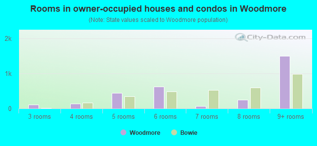
- Rooms in owner-occupied houses and condos in Woodmore
- 01 room
- 02 rooms
- 1133 rooms
- 1404 rooms
- 4515 rooms
- 6266 rooms
- 677 rooms
- 2538 rooms
- 1,5019+ rooms
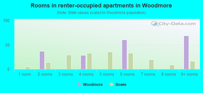
- Rooms in renter-occupied apartments in Woodmore
- 01 room
- 372 rooms
- 03 rooms
- 294 rooms
- 05 rooms
- 616 rooms
- 07 rooms
- 08 rooms
- 699+ rooms
Owner-occupied
Renter-occupied
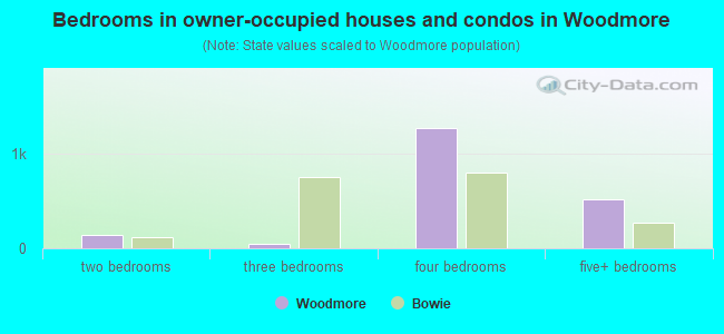
- Bedrooms in owner-occupied houses and condos in Woodmore
- 0no bedroom
- 01 bedroom
- 1402 bedrooms
- 443 bedrooms
- 1,2654 bedrooms
- 5115+ bedrooms
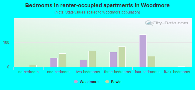
- Bedrooms in renter-occupied apartments in Woodmore
- 0no bedroom
- 371 bedroom
- 292 bedrooms
- 613 bedrooms
- 1314 bedrooms
- 05+ bedrooms
Average number of cars or other vehicles available in houses/condos:
Average number of cars or other vehicles available in apartments:
| This neighborhood: | 4.5 |
| Bowie: | 2.2 |
Average number of cars or other vehicles available in apartments:
| Here: | 8.9 |
| city: | 1.5 |
Percentage of units with a mortgage:
| Woodmore: | 70.8% |
| Bowie: | 82.5% |
Average estimated value of detached houses in 2022 (100.0% of all units):
| Woodmore: | $919,555 |
| Maryland: | $526,819 |
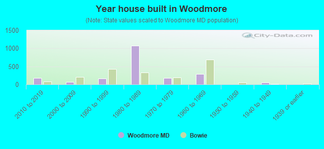
- Year house built in Woodmore
- 02020 or later
- 1852010 to 2019
- 672000 to 2009
- 1681990 to 1999
- 1,0741980 to 1989
- 1791970 to 1979
- 2861960 to 1969
- 01950 to 1959
- 611940 to 1949
- 01939 or earlier
City-data.com crime index for city in 2020 (higher means more crime):
| City: | 74.0 |
| U.S. average: | 219.5 |
Travel time to work (commute)
![Travel time to work (commute)]()
- 205 to 9 minutes
- 27610 to 14 minutes
- 41915 to 19 minutes
- 57320 to 24 minutes
- 54125 to 29 minutes
- 1,67730 to 34 minutes
- 43635 to 39 minutes
- 18040 to 44 minutes
- 41045 to 59 minutes
- 82460 to 89 minutes
- 24790 or more minutes

Means of transportation to work
![Means of transportation to work]()
- 60.7%1,209Drove a car alone
- 10.1%202Carpooled
- 7.7%154Bus
- 7.3%146Subway or elevated rail
- 2.5%49Walked
- 2.8%55Other means
- 21.7%433Worked at home

Time leaving home to go to work
![Time leaving home to go to work]()
- 17712:00 a.m. to 4:59 a.m.
- 3985:00 a.m. to 5:29 a.m.
- 1685:30 a.m. to 5:59 a.m.
- 6086:00 a.m. to 6:29 a.m.
- 5856:30 a.m. to 6:59 a.m.
- 5567:00 a.m. to 7:29 a.m.
- 5677:30 a.m. to 7:59 a.m.
- 8968:00 a.m. to 8:29 a.m.
- 4638:30 a.m. to 8:59 a.m.
- 5539:00 a.m. to 9:59 a.m.
- 33110:00 a.m. to 10:59 a.m.
- 23811:00 a.m. to 11:59 a.m.
- 17112:00 p.m. to 3:59 p.m.
- 4974:00 p.m. to 11:59 p.m.

Occupations of males:
- Percentage of males in management occupations (except farmers):
Here: 4.7% city: 12.9%
- Percentage of males in business and financial operations occupations:
Here: 8.9% city: 9.7%
- Percentage of males in computer and mathematical occupations:
Here: 11.9% city: 11.0%
- Percentage of males in architecture and engineering occupations:
Here: 6.0% city: 1.5%
- Percentage of males in life, physical, and social science occupations:
Here: 1.9% city: 2.6%
- Percentage of males in legal occupations:
Here: 6.0% city: 1.5%
- Percentage of males in education, training, and library occupations:
Here: 5.1% city: 4.3%
- Percentage of males in arts, design, entertainment, sports, and media occupations:
Here: 1.9% city: 2.2%
- Percentage of males in healthcare practitioners and technical occupations:
Here: 13.3% city: 2.1%
- Percentage of males in service occupations:
Here: 27.7% city: 14.7%
- Percentage of males in sales and office occupations:
Here: 2.6% city: 13.8%
- Percentage of males in construction, extraction, and maintenance occupations:
Here: 19.5% city: 6.3%
- Percentage of males in production occupations:
Here: 6.6% city: 2.8%
- Percentage of males in transportation occupations:
Here: 14.9% city: 3.7%
- Percentage of males in material moving occupations:
Here: 20.1% city: 2.7%
Occupations of females:
- Percentage of females in management occupations (except farmers):
Here: 11.4% city: 14.7%
- Percentage of females in business and financial operations occupations:
Here: 10.3% city: 12.9%
- Percentage of females in computer and mathematical occupations:
Here: 7.1% city: 6.2%
- Percentage of females in architecture and engineering occupations:
Here: 6.5% city: 0.6%
- Percentage of females in community and social services occupations:
Here: 5.4% city: 4.6%
- Percentage of females in legal occupations:
Here: 7.6% city: 1.3%
- Percentage of females in education, training, and library occupations:
Here: 19.6% city: 10.9%
- Percentage of females in arts, design, entertainment, sports, and media occupations:
Here: 7.1% city: 1.5%
- Percentage of females in healthcare practitioners and technical occupations:
Here: 17.4% city: 7.9%
- Percentage of females in service occupations:
Here: 7.6% city: 11.1%
- Percentage of females in sales and office occupations:
Here: 83.2% city: 24.1%
- Percentage of females in farming, fishing, and forestry occupations:
Here: 3.2% city: 0.1%
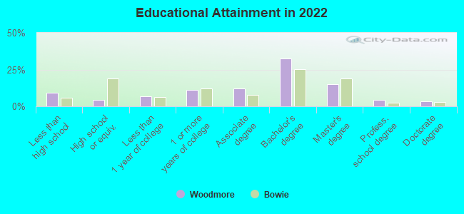
Education in this neighborhood (subdivision or community):
- Percentage of people 3 years and older in K-12 schools:
Woodmore: 14.0% Bowie: 16.7%
- Percentage of people 3 years and older in undergraduate colleges:
Woodmore: 5.6% Bowie: 4.9%
- Percentage of people 3 years and older in grad. or professional schools:
Woodmore: 5.7% Bowie: 2.9%
- Percentage of students K-12 enrolled in private schools:
Woodmore: 40.5% Bowie: 23.5%
Percentage of population below poverty level:
| Woodmore: | 4.7% |
| Bowie: | 3.4% |
Median year owner moved in (as recorded in 2022):
| Woodmore: | 1993 |
| Bowie: | 2007 |
Percentage of married-couple families with both working:
| Woodmore: | 139.7% |
| Bowie: | 80.6% |
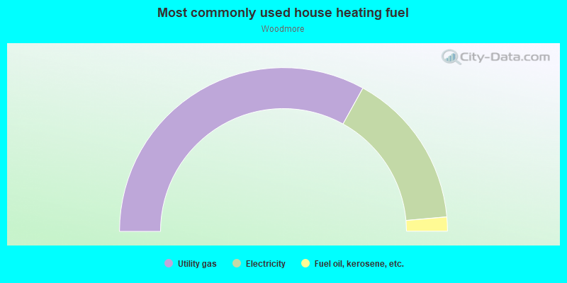
- 66.1%Utility gas
- 31.1%Electricity
- 2.8%Fuel oil, kerosene, etc.
Highways in this neighborhood:
State Hwy 193 (Enterprise Rd)
Length: 4.22 miles
Directions: N-S, SE-NW, SW-NE
Address range: 800 to 3998
Directions: N-S, SE-NW, SW-NE
Address range: 800 to 3998
John Hanson Hwy (US Hwy 50, Cobb Rd)
Length: 1.68 miles
Direction: E-W
Direction: E-W
State Hwy 214 (Central Ave)
Length: 1.07 miles
Direction: E-W
Address range: 11800 to 12619
Direction: E-W
Address range: 11800 to 12619
Roads and streets:
Woodmore Rd
Length: 3.08 miles
Directions: E-W, SW-NE
Address range: 11700 to 13099
Directions: E-W, SW-NE
Address range: 11700 to 13099
Pleasant Prospect
Length: 1.83 miles
Directions: E-W, N-S, SE-NW, SW-NE
Address range: 11922 to 12612
Directions: E-W, N-S, SE-NW, SW-NE
Address range: 11922 to 12612
Albert Dr
Length: 1.35 miles
Directions: E-W, N-S, SE-NW, SW-NE
Address range: 1404 to 1774
Directions: E-W, N-S, SE-NW, SW-NE
Address range: 1404 to 1774
Chantilly Ln
Length: 1.22 miles
Directions: E-W, N-S, SE-NW, SW-NE
Address range: 11100 to 11999
Directions: E-W, N-S, SE-NW, SW-NE
Address range: 11100 to 11999
Spriggs Request Way
Length: 1.08 miles
Directions: E-W, N-S, SE-NW, SW-NE
Address range: 2800 to 3326
Directions: E-W, N-S, SE-NW, SW-NE
Address range: 2800 to 3326
Lottsford Rd
Length: 1.05 miles
Direction: E-W
Address range: 11100 to 11698
Direction: E-W
Address range: 11100 to 11698
Waesche Dr
Length: 1.03 miles
Directions: E-W, N-S, SE-NW, SW-NE
Address range: 1400 to 11618
Directions: E-W, N-S, SE-NW, SW-NE
Address range: 1400 to 11618
Lottsford Vista Rd
Length: 0.94 miles
Directions: N-S, SE-NW
Address range: 2200 to 3207
Directions: N-S, SE-NW
Address range: 2200 to 3207
Parkside Dr
Length: 0.92 miles
Directions: E-W, N-S, SE-NW, SW-NE
Address range: 1700 to 2324
Directions: E-W, N-S, SE-NW, SW-NE
Address range: 1700 to 2324
Old Lottsford Rd
Length: 0.87 miles
Directions: E-W, SE-NW, SW-NE
Address range: 11100 to 11641
Directions: E-W, SE-NW, SW-NE
Address range: 11100 to 11641
Longwater
Length: 0.75 miles
Directions: E-W, N-S, SE-NW, SW-NE
Address range: 12300 to 12715
Directions: E-W, N-S, SE-NW, SW-NE
Address range: 12300 to 12715
Sunflower Cir
Length: 0.74 miles
Directions: E-W, N-S, SE-NW, SW-NE
Address range: 3800 to 3947
Directions: E-W, N-S, SE-NW, SW-NE
Address range: 3800 to 3947
Courtside Rd
Length: 0.72 miles
Directions: E-W, N-S, SE-NW, SW-NE
Address range: 2900 to 3199
Directions: E-W, N-S, SE-NW, SW-NE
Address range: 2900 to 3199
Kings Tree Dr
Length: 0.67 miles
Directions: E-W, N-S, SE-NW, SW-NE
Address range: 1000 to 1299
Directions: E-W, N-S, SE-NW, SW-NE
Address range: 1000 to 1299
Kings Manor Dr
Length: 0.63 miles
Directions: E-W, N-S, SE-NW, SW-NE
Address range: 1400 to 1712
Directions: E-W, N-S, SE-NW, SW-NE
Address range: 1400 to 1712
Saint Georges Way
Length: 0.62 miles
Directions: E-W, N-S, SE-NW
Address range: 1700 to 2199
Directions: E-W, N-S, SE-NW
Address range: 1700 to 2199
Shadystone Ter
Length: 0.61 miles
Directions: E-W, SE-NW, SW-NE
Address range: 11700 to 12015
Directions: E-W, SE-NW, SW-NE
Address range: 11700 to 12015
Kencrest Dr
Length: 0.58 miles
Directions: E-W, N-S, SE-NW, SW-NE
Address range: 10800 to 11322
Directions: E-W, N-S, SE-NW, SW-NE
Address range: 10800 to 11322
Clairton Dr
Length: 0.57 miles
Directions: E-W, N-S, SE-NW, SW-NE
Address range: 3500 to 4099
Directions: E-W, N-S, SE-NW, SW-NE
Address range: 3500 to 4099
Kings Valley Dr
Length: 0.56 miles
Directions: N-S, SW-NE
Address range: 900 to 1499
Directions: N-S, SW-NE
Address range: 900 to 1499
Kings Heather Dr
Length: 0.56 miles
Directions: E-W, N-S, SE-NW, SW-NE
Address range: 1000 to 1321
Directions: E-W, N-S, SE-NW, SW-NE
Address range: 1000 to 1321
Belvidere Rd
Length: 0.55 miles
Direction: E-W
Address range: 11400 to 11899
Direction: E-W
Address range: 11400 to 11899
Old York Rd
Length: 0.52 miles
Directions: E-W, N-S, SW-NE
Address range: 11000 to 11299
Directions: E-W, N-S, SW-NE
Address range: 11000 to 11299
Woodbridge Ct
Length: 0.51 miles
Directions: E-W, N-S, SW-NE
Address range: 12500 to 12723
Directions: E-W, N-S, SW-NE
Address range: 12500 to 12723
Bishops Content Rd
Length: 0.48 miles
Directions: E-W, N-S, SE-NW, SW-NE
Address range: 11700 to 11828
Directions: E-W, N-S, SE-NW, SW-NE
Address range: 11700 to 11828
Trillum St
Length: 0.43 miles
Directions: E-W, N-S, SW-NE
Address range: 11400 to 11710
Directions: E-W, N-S, SW-NE
Address range: 11400 to 11710
St Michaels Dr
Length: 0.42 miles
Directions: N-S, SE-NW, SW-NE
Address range: 700 to 1999
Directions: N-S, SE-NW, SW-NE
Address range: 700 to 1999
Dundee Dr
Length: 0.40 miles
Directions: E-W, N-S, SE-NW
Address range: 11300 to 11599
Directions: E-W, N-S, SE-NW
Address range: 11300 to 11599
Woodvale Ln
Length: 0.40 miles
Directions: E-W, N-S, SE-NW
Address range: 2001 to 2309
Directions: E-W, N-S, SE-NW
Address range: 2001 to 2309
Woodwalk Ter
Length: 0.39 miles
Directions: E-W, N-S, SE-NW, SW-NE
Address range: 12300 to 12399
Directions: E-W, N-S, SE-NW, SW-NE
Address range: 12300 to 12399
Shadowrock Ln
Length: 0.38 miles
Directions: E-W, N-S, SE-NW, SW-NE
Address range: 1800 to 2099
Directions: E-W, N-S, SE-NW, SW-NE
Address range: 1800 to 2099
Kings Arrow St
Length: 0.37 miles
Direction: E-W
Address range: 12100 to 12299
Direction: E-W
Address range: 12100 to 12299
Woodsong Ln
Length: 0.37 miles
Directions: E-W, SW-NE
Address range: 12501 to 12524
Directions: E-W, SW-NE
Address range: 12501 to 12524
Cleaver Dr
Length: 0.36 miles
Directions: E-W, SW-NE
Address range: 11800 to 12099
Directions: E-W, SW-NE
Address range: 11800 to 12099
Woodshade Ct
Length: 0.33 miles
Directions: E-W, N-S, SE-NW, SW-NE
Address range: 1901 to 2061
Directions: E-W, N-S, SE-NW, SW-NE
Address range: 1901 to 2061
Kingsview St
Length: 0.33 miles
Directions: E-W, N-S, SW-NE
Address range: 12400 to 12616
Directions: E-W, N-S, SW-NE
Address range: 12400 to 12616
Brookeville Lndg
Length: 0.33 miles
Directions: N-S, SE-NW
Address range: 2600 to 2699
Directions: N-S, SE-NW
Address range: 2600 to 2699
Marjorie Dr
Length: 0.33 miles
Directions: E-W, SW-NE
Address range: 11500 to 11620
Directions: E-W, SW-NE
Address range: 11500 to 11620
Southwood Ct
Length: 0.32 miles
Direction: N-S
Address range: 1800 to 1923
Direction: N-S
Address range: 1800 to 1923
Kingsbury Dr
Length: 0.32 miles
Directions: E-W, N-S, SE-NW, SW-NE
Address range: 1200 to 1298
Directions: E-W, N-S, SE-NW, SW-NE
Address range: 1200 to 1298
Clearwood Dr
Length: 0.31 miles
Directions: N-S, SE-NW
Address range: 2000 to 2098
Directions: N-S, SE-NW
Address range: 2000 to 2098
Locust Glen Dr
Length: 0.31 miles
Direction: E-W
Address range: 11600 to 11804
Direction: E-W
Address range: 11600 to 11804
Kingswell St
Length: 0.31 miles
Directions: E-W, N-S, SE-NW, SW-NE
Address range: 12200 to 12299
Directions: E-W, N-S, SE-NW, SW-NE
Address range: 12200 to 12299
Myer Rd
Length: 0.30 miles
Directions: E-W, N-S, SE-NW, SW-NE
Address range: 2500 to 11599
Directions: E-W, N-S, SE-NW, SW-NE
Address range: 2500 to 11599
Aynor Dr
Length: 0.30 miles
Directions: E-W, N-S, SE-NW, SW-NE
Address range: 3600 to 3909
Directions: E-W, N-S, SE-NW, SW-NE
Address range: 3600 to 3909
Decesaris Blvd
Length: 0.30 miles
Directions: E-W, N-S, SW-NE
Address range: 11700 to 11827
Directions: E-W, N-S, SW-NE
Address range: 11700 to 11827
Baskerville Dr
Length: 0.30 miles
Directions: E-W, N-S, SE-NW
Address range: 3600 to 3899
Directions: E-W, N-S, SE-NW
Address range: 3600 to 3899
Whittier Rd
Length: 0.28 miles
Directions: E-W, N-S, SE-NW, SW-NE
Address range: 11600 to 11799
Directions: E-W, N-S, SE-NW, SW-NE
Address range: 11600 to 11799
Sondberg Ln
Length: 0.28 miles
Directions: E-W, N-S, SE-NW
Address range: 12102 to 12114
Directions: E-W, N-S, SE-NW
Address range: 12102 to 12114
Earlston Dr
Length: 0.27 miles
Directions: E-W, SW-NE
Address range: 11300 to 11499
Directions: E-W, SW-NE
Address range: 11300 to 11499
Lottsford Ter
Length: 0.27 miles
Directions: E-W, N-S, SE-NW, SW-NE
Address range: 11500 to 11519
Directions: E-W, N-S, SE-NW, SW-NE
Address range: 11500 to 11519
Hallandale Ter
Length: 0.24 miles
Directions: E-W, SE-NW
Address range: 12000 to 12087
Directions: E-W, SE-NW
Address range: 12000 to 12087
Brookville Landing Ct
Length: 0.24 miles
Directions: E-W, SE-NW
Address range: 2600 to 11834
Directions: E-W, SE-NW
Address range: 2600 to 11834
St Francis Way
Length: 0.24 miles
Directions: E-W, SW-NE
Address range: 11900 to 11952
Directions: E-W, SW-NE
Address range: 11900 to 11952
Shortridge Ln
Length: 0.23 miles
Directions: E-W, N-S, SE-NW, SW-NE
Address range: 3200 to 3312
Directions: E-W, N-S, SE-NW, SW-NE
Address range: 3200 to 3312
Waterleaf Way
Length: 0.22 miles
Direction: N-S
Address range: 2000 to 2120
Direction: N-S
Address range: 2000 to 2120
Kingsgate St
Length: 0.22 miles
Directions: E-W, N-S, SW-NE
Address range: 1400 to 1519
Directions: E-W, N-S, SW-NE
Address range: 1400 to 1519
Burleigh Dr
Length: 0.22 miles
Directions: N-S, SE-NW
Address range: 3500 to 3699
Directions: N-S, SE-NW
Address range: 3500 to 3699
Canterbury Ct
Length: 0.22 miles
Directions: E-W, SW-NE
Address range: 11400 to 11520
Directions: E-W, SW-NE
Address range: 11400 to 11520
Kingshill St
Length: 0.22 miles
Directions: N-S, SE-NW, SW-NE
Address range: 1500 to 1531
Directions: N-S, SE-NW, SW-NE
Address range: 1500 to 1531
Bayard Dr
Length: 0.20 miles
Directions: N-S, SE-NW
Address range: 11400 to 11509
Directions: N-S, SE-NW
Address range: 11400 to 11509
Prospect Lndg
Length: 0.18 miles
Directions: E-W, SE-NW, SW-NE
Address range: 12200 to 12399
Directions: E-W, SE-NW, SW-NE
Address range: 12200 to 12399
Hudee Dr
Length: 0.18 miles
Directions: E-W, SW-NE
Address range: 3800 to 3999
Directions: E-W, SW-NE
Address range: 3800 to 3999
Brady Ct
Length: 0.17 miles
Directions: E-W, N-S, SE-NW, SW-NE
Address range: 1400 to 1599
Directions: E-W, N-S, SE-NW, SW-NE
Address range: 1400 to 1599
Yellowwood Ln
Length: 0.17 miles
Direction: E-W
Direction: E-W
Ayden Ct
Length: 0.16 miles
Directions: E-W, N-S, SE-NW
Address range: 4000 to 4023
Directions: E-W, N-S, SE-NW
Address range: 4000 to 4023
Woodlake Rd
Length: 0.16 miles
Directions: E-W, N-S, SE-NW, SW-NE
Address range: 2700 to 2799
Directions: E-W, N-S, SE-NW, SW-NE
Address range: 2700 to 2799
Chesley Ct
Length: 0.15 miles
Directions: E-W, SW-NE
Address range: 11500 to 11522
Directions: E-W, SW-NE
Address range: 11500 to 11522
Locust Dale Ct
Length: 0.15 miles
Directions: E-W, SE-NW
Address range: 11700 to 11899
Directions: E-W, SE-NW
Address range: 11700 to 11899
Candor Dr
Length: 0.14 miles
Directions: E-W, SW-NE
Address range: 11600 to 11699
Directions: E-W, SW-NE
Address range: 11600 to 11699
Apricot Ct
Length: 0.14 miles
Directions: E-W, N-S, SW-NE
Address range: 2100 to 2120
Directions: E-W, N-S, SW-NE
Address range: 2100 to 2120
Kingsford Ct
Length: 0.13 miles
Directions: E-W, SE-NW, SW-NE
Address range: 12200 to 12299
Directions: E-W, SE-NW, SW-NE
Address range: 12200 to 12299
Waesche Pl
Length: 0.13 miles
Direction: SE-NW
Address range: 1800 to 1916
Direction: SE-NW
Address range: 1800 to 1916
Birkdale Ct
Length: 0.13 miles
Directions: N-S, SW-NE
Address range: 11300 to 11399
Directions: N-S, SW-NE
Address range: 11300 to 11399
Woodbrook Ct
Length: 0.12 miles
Direction: E-W
Address range: 11800 to 11899
Direction: E-W
Address range: 11800 to 11899
Kingsbrook St
Length: 0.12 miles
Directions: E-W, N-S, SE-NW
Address range: 12200 to 12299
Directions: E-W, N-S, SE-NW
Address range: 12200 to 12299
Millers Ter
Length: 0.12 miles
Directions: E-W, SE-NW
Address range: 11200 to 11299
Directions: E-W, SE-NW
Address range: 11200 to 11299
Saint Edmund Way
Length: 0.11 miles
Direction: SW-NE
Address range: 12900 to 12909
Direction: SW-NE
Address range: 12900 to 12909
Marco Dr
Length: 0.11 miles
Direction: N-S
Address range: 1401 to 1413
Direction: N-S
Address range: 1401 to 1413
St Gregory Ct
Length: 0.11 miles
Direction: E-W
Address range: 12999 to 13002
Direction: E-W
Address range: 12999 to 13002
Flora Ln
Length: 0.11 miles
Directions: E-W, SE-NW
Address range: 11800 to 11899
Directions: E-W, SE-NW
Address range: 11800 to 11899
Sunflower Pl
Length: 0.11 miles
Directions: N-S, SW-NE
Address range: 3500 to 3519
Directions: N-S, SW-NE
Address range: 3500 to 3519
Progress Ln
Length: 0.11 miles
Directions: E-W, SW-NE
Address range: 11900 to 11999
Directions: E-W, SW-NE
Address range: 11900 to 11999
Red Cedar Dr
Length: 0.10 miles
Direction: SE-NW
Address range: 2500 to 2522
Direction: SE-NW
Address range: 2500 to 2522
Kingstead Ct
Length: 0.10 miles
Directions: N-S, SE-NW
Address range: 12500 to 12517
Directions: N-S, SE-NW
Address range: 12500 to 12517
Woodwind Ln
Length: 0.10 miles
Directions: E-W, SW-NE
Address range: 12100 to 12113
Directions: E-W, SW-NE
Address range: 12100 to 12113
Sundew Ct
Length: 0.09 miles
Directions: N-S, SW-NE
Address range: 1600 to 1619
Directions: N-S, SW-NE
Address range: 1600 to 1619
Royal Grant Cir
Length: 0.09 miles
Directions: E-W, N-S, SW-NE
Address range: 11000 to 11019
Directions: E-W, N-S, SW-NE
Address range: 11000 to 11019
Trelawn
Length: 0.09 miles
Direction: E-W
Address range: 12500 to 12508
Direction: E-W
Address range: 12500 to 12508
Kingsdale Ct
Length: 0.09 miles
Direction: SW-NE
Address range: 1100 to 1113
Direction: SW-NE
Address range: 1100 to 1113
Albert Ter
Length: 0.09 miles
Direction: SE-NW
Address range: 1700 to 1715
Direction: SE-NW
Address range: 1700 to 1715
Coral Root Ct
Length: 0.09 miles
Direction: E-W
Address range: 11501 to 115011
Direction: E-W
Address range: 11501 to 115011
Spriggs Request Ct
Length: 0.08 miles
Directions: N-S, SW-NE
Address range: 12601 to 12625
Directions: N-S, SW-NE
Address range: 12601 to 12625
Sunflower Ct
Length: 0.08 miles
Direction: E-W
Address range: 10900 to 10913
Direction: E-W
Address range: 10900 to 10913
Saint Regis Way
Length: 0.08 miles
Direction: N-S
Address range: 2091 to 2999
Direction: N-S
Address range: 2091 to 2999
Prima Rd (Prima Way)
Length: 0.08 miles
Directions: N-S, SE-NW
Address range: 2300 to 2316
Directions: N-S, SE-NW
Address range: 2300 to 2316
Kingsfair Ct
Length: 0.08 miles
Directions: N-S, SE-NW
Address range: 4000 to 4016
Directions: N-S, SE-NW
Address range: 4000 to 4016
Kings Valley Ct
Length: 0.08 miles
Directions: N-S, SE-NW, SW-NE
Address range: 12300 to 12607
Directions: N-S, SE-NW, SW-NE
Address range: 12300 to 12607
Kencrest Ct
Length: 0.07 miles
Directions: E-W, N-S, SW-NE
Address range: 3900 to 3913
Directions: E-W, N-S, SW-NE
Address range: 3900 to 3913
Saint Edmund Ter
Length: 0.07 miles
Direction: SE-NW
Address range: 3100 to 3104
Direction: SE-NW
Address range: 3100 to 3104
Venison Ln
Length: 0.07 miles
Directions: E-W, SE-NW
Address range: 11800 to 11899
Directions: E-W, SE-NW
Address range: 11800 to 11899
Queens Wood Ter
Length: 0.07 miles
Directions: E-W, SW-NE
Address range: 11100 to 11199
Directions: E-W, SW-NE
Address range: 11100 to 11199
Waesche Ct
Length: 0.07 miles
Direction: SW-NE
Address range: 1800 to 1812
Direction: SW-NE
Address range: 1800 to 1812
Crepe Ct
Length: 0.07 miles
Directions: N-S, SW-NE
Address range: 2100 to 2110
Directions: N-S, SW-NE
Address range: 2100 to 2110
Albert Ct
Length: 0.06 miles
Directions: E-W, SE-NW
Address range: 1700 to 7812
Directions: E-W, SE-NW
Address range: 1700 to 7812
Jester Ct
Length: 0.06 miles
Directions: E-W, SE-NW
Address range: 11800 to 11899
Directions: E-W, SE-NW
Address range: 11800 to 11899
Gerald Dr
Length: 0.06 miles
Directions: N-S, SE-NW
Directions: N-S, SE-NW
Kings Ter
Length: 0.06 miles
Directions: E-W, SE-NW
Address range: 12600 to 12613
Directions: E-W, SE-NW
Address range: 12600 to 12613
Clairton Ct
Length: 0.06 miles
Direction: E-W
Address range: 11600 to 11699
Direction: E-W
Address range: 11600 to 11699
Rock Elm Ct
Length: 0.06 miles
Direction: SW-NE
Address range: 11400 to 11414
Direction: SW-NE
Address range: 11400 to 11414
Hudee Ct
Length: 0.06 miles
Directions: N-S, SE-NW
Address range: 11100 to 11112
Directions: N-S, SE-NW
Address range: 11100 to 11112
Trillum Ct
Length: 0.05 miles
Direction: SE-NW
Address range: 1600 to 1699
Direction: SE-NW
Address range: 1600 to 1699
Tommy Ct
Length: 0.05 miles
Direction: E-W
Address range: 11500 to 11511
Direction: E-W
Address range: 11500 to 11511
Rosemary Ct
Length: 0.05 miles
Directions: N-S, SE-NW
Address range: 1400 to 1413
Directions: N-S, SE-NW
Address range: 1400 to 1413
Belfry Ln
Length: 0.05 miles
Direction: SW-NE
Address range: 2100 to 2111
Direction: SW-NE
Address range: 2100 to 2111
Sunflower Ter
Length: 0.05 miles
Directions: E-W, SE-NW
Address range: 10800 to 10812
Directions: E-W, SE-NW
Address range: 10800 to 10812
Trevor Ct
Length: 0.05 miles
Direction: SW-NE
Address range: 11200 to 11213
Direction: SW-NE
Address range: 11200 to 11213
Kings Heather Ct
Length: 0.05 miles
Direction: SW-NE
Address range: 12405 to 12499
Direction: SW-NE
Address range: 12405 to 12499
Earlston Ct
Length: 0.05 miles
Direction: SE-NW
Address range: 3600 to 3699
Direction: SE-NW
Address range: 3600 to 3699
Marisa Ct
Length: 0.04 miles
Direction: E-W
Address range: 11100 to 11113
Direction: E-W
Address range: 11100 to 11113
Poe Ct
Length: 0.04 miles
Directions: E-W, N-S, SE-NW
Address range: 3800 to 3899
Directions: E-W, N-S, SE-NW
Address range: 3800 to 3899
Kingsbrook Ct
Length: 0.04 miles
Directions: E-W, SW-NE
Address range: 1300 to 1399
Directions: E-W, SW-NE
Address range: 1300 to 1399
Kings Pl
Length: 0.04 miles
Direction: E-W
Address range: 12600 to 12609
Direction: E-W
Address range: 12600 to 12609
Biscoe Ct
Length: 0.04 miles
Directions: N-S, SE-NW
Address range: 3900 to 3909
Directions: N-S, SE-NW
Address range: 3900 to 3909
Prospect Green
Length: 0.03 miles
Direction: N-S
Address range: 2500 to 2510
Direction: N-S
Address range: 2500 to 2510
Michie Dr
Length: 0.03 miles
Direction: SW-NE
Direction: SW-NE
Foxwood Cir
Length: 0.03 miles
Direction: SW-NE
Address range: 1801 to 1869
Direction: SW-NE
Address range: 1801 to 1869
Kingsgate Ct
Length: 0.03 miles
Direction: SE-NW
Address range: 12600 to 12609
Direction: SE-NW
Address range: 12600 to 12609
Other features:
Northeast Br
Length: 3.23 miles
Directions: E-W, N-S, SE-NW, SW-NE
Directions: E-W, N-S, SE-NW, SW-NE
Lottsford Br
Length: 1.94 miles
Directions: E-W, N-S, SE-NW, SW-NE
Directions: E-W, N-S, SE-NW, SW-NE
Western Br
Length: 0.97 miles
Directions: E-W, N-S, SE-NW
Directions: E-W, N-S, SE-NW
Bald Hill Br
Length: 0.44 miles
Directions: N-S, SE-NW
Directions: N-S, SE-NW
Western Branch Tributary
Length: 0.43 miles
Directions: E-W, N-S, SW-NE
Directions: E-W, N-S, SW-NE
Folly Br
Length: 0.24 miles
Directions: N-S, SW-NE
Directions: N-S, SW-NE