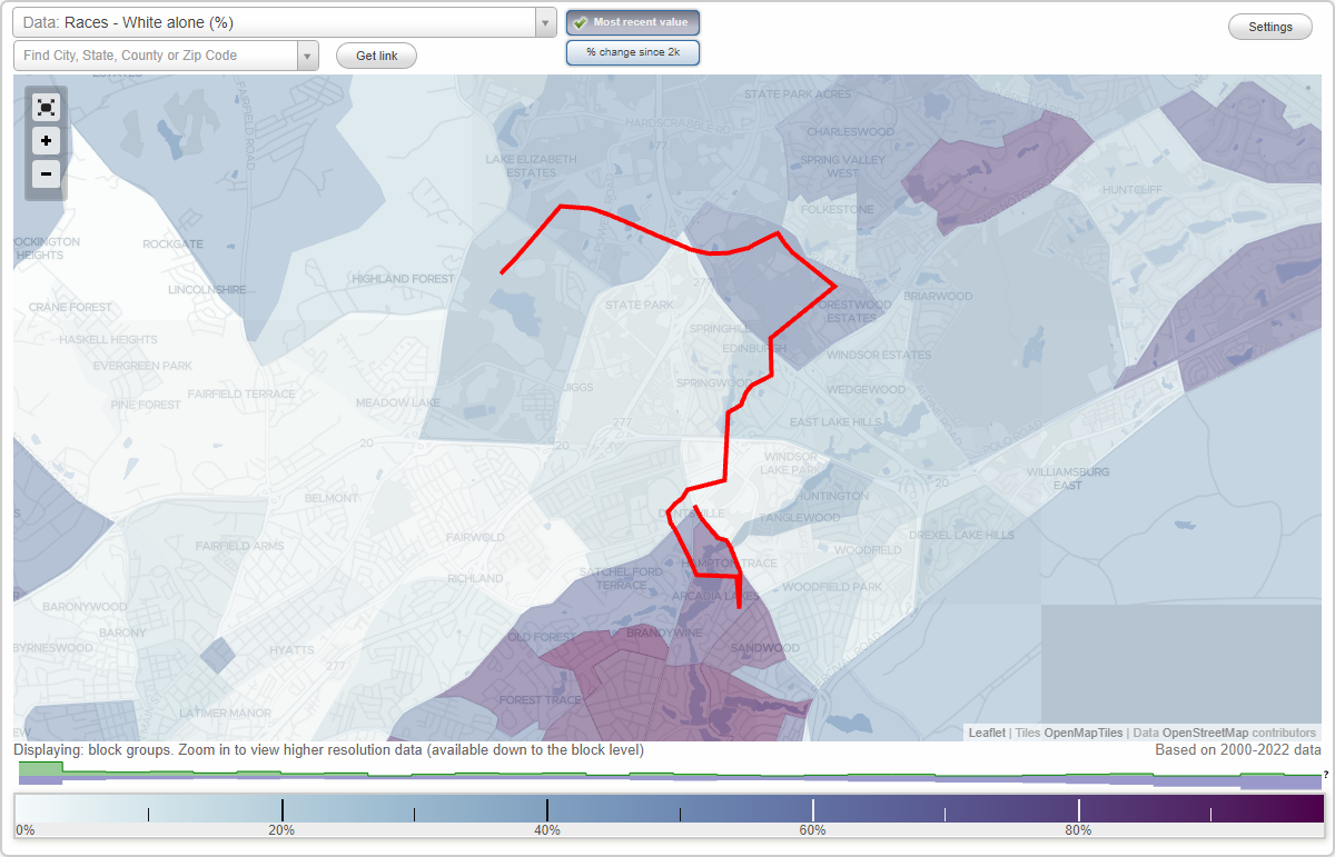
Woodfield neighborhood in Columbia, South Carolina (SC), 29223 detailed profile
Settings
X

Business Search - 14 Million verified businesses
Area: 3.459 square miles
Population: 11,254
Population density:
| Woodfield: | 3,254 people per square mile |
| Columbia: | 1,113 people per square mile |

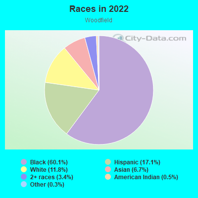
- 7,03060.1%Black
- 2,00517.1%Hispanic or Latino
- 1,37811.8%White
- 7886.7%Asian
- 3993.4%Two or more races
- 640.5%American Indian
- 320.3%Some other race
Distribution of median household income
![Distribution of median household income]()
- 741Less than $10,000
- 607$10,000 to $19,999
- 649$20,000 to $29,999
- 1,258$30,000 to $39,999
- 888$40,000 to $49,999
- 338$50,000 to $59,999
- 277$60,000 to $74,999
- 586$75,000 to $99,999
- 452$100,000 to $124,999
- 278$125,000 to $149,999
- 512$150,000 to $199,999
- 48$200,000 or more

Distribution of owner-occupied house/condo value
![Distribution of owner-occupied house/condo value]()
- 667Less than $50,000
- 1,165$50,000 to $99,999
- 1,278$100,000 to $149,999
- 623$150,000 to $199,999
- 310$200,000 to $249,999
- 324$250,000 to $299,999
- 831$300,000 to $399,999
- 244$400,000 to $499,999
- 54$500,000 to $749,999
- 4$750,000 to $999,999
- 8$1,000,000 or more

Distribution of rent paid by renters
![Distribution of rent paid by renters]()
- 363Less than $100
- 301$100 to $199
- 414$200 to $299
- 329$300 to $399
- 294$400 to $499
- 593$500 to $599
- 475$600 to $699
- 908$700 to $799
- 705$800 to $899
- 642$900 to $999
- 481$1,000 to $1,249
- 1,242$1,250 to $1,499
- 249$1,500 to $1,999
- 132$2,000 or more

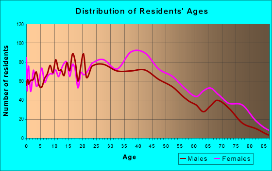
| Males: | 5,591 |
| Females: | 5,663 |
Males:
| This neighborhood: | 36.5 years |
| Whole city: | 27.5 years |
| This neighborhood: | 40.6 years |
| Whole city: | 29.3 years |
Average household size:
| Woodfield: | 3.7 people |
| Columbia: | 2.1 people |
Percentage of family households:
| Woodfield: | 49.7% |
| Columbia: | 35.2% |
| Here: | 26.4% |
| Columbia: | 27.5% |
Percentage of married-couple families with children (among all households):
| Woodfield: | 8.1% |
| Columbia: | 23.7% |
Percentage of single-mother households (among all households):
| Woodfield: | 22.1% |
| Columbia: | 12.1% |
Percentage of never married males 15 years old and over:
Percentage of never married females 15 years old and over:
| Woodfield: | 21.4% |
| Columbia: | 31.8% |
Percentage of never married females 15 years old and over:
| Woodfield: | 21.3% |
| city: | 26.3% |
Percentage of people that speak English not well or not at all:
| Woodfield: | 4.4% |
| Columbia: | 0.6% |
Percentage of people born in this state:
Percentage of people born in another U.S. state:
Percentage of native residents but born outside the U.S.:
Percentage of foreign born residents:
| Here: | 53.7% |
| Columbia: | 53.1% |
Percentage of people born in another U.S. state:
| Woodfield: | 26.9% |
| Columbia: | 40.1% |
Percentage of native residents but born outside the U.S.:
| Here: | 1.4% |
| city: | 2.2% |
Percentage of foreign born residents:
| Here: | 18.0% |
| Columbia: | 4.6% |
Owner-occupied
Renter-occupied

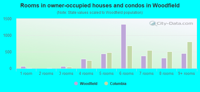
- Rooms in owner-occupied houses and condos in Woodfield
- 621 room
- 02 rooms
- 663 rooms
- 2864 rooms
- 4425 rooms
- 1,3296 rooms
- 3767 rooms
- 3158 rooms
- 4569+ rooms
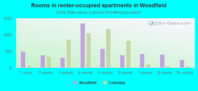
- Rooms in renter-occupied apartments in Woodfield
- 4961 room
- 3932 rooms
- 3143 rooms
- 1,3644 rooms
- 5805 rooms
- 3896 rooms
- 4247 rooms
- 4038 rooms
- 2489+ rooms
Owner-occupied
Renter-occupied
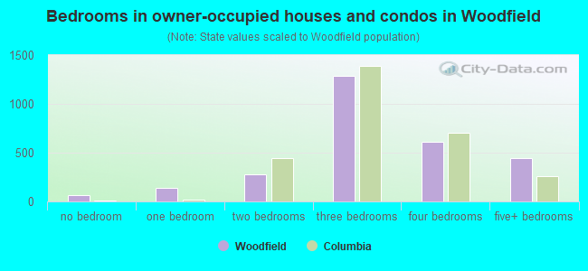
- Bedrooms in owner-occupied houses and condos in Woodfield
- 62no bedroom
- 1401 bedroom
- 2762 bedrooms
- 1,2833 bedrooms
- 6094 bedrooms
- 4485+ bedrooms
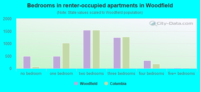
- Bedrooms in renter-occupied apartments in Woodfield
- 496no bedroom
- 4951 bedroom
- 1,5452 bedrooms
- 1,2493 bedrooms
- 3264 bedrooms
- 285+ bedrooms
Average number of cars or other vehicles available in houses/condos:
Average number of cars or other vehicles available in apartments:
| This neighborhood: | 1.7 |
| Columbia: | 1.8 |
Average number of cars or other vehicles available in apartments:
| Here: | 1.3 |
| city: | 1.3 |
Percentage of units with a mortgage:
| Woodfield: | 63.9% |
| Columbia: | 67.5% |
Average estimated value of detached houses in 2022 (58.9% of all units):
| Woodfield: | $195,210 |
| Columbia: | $305,357 |
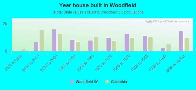
- Year house built in Woodfield
- 02020 or later
- 6812010 to 2019
- 1,5992000 to 2009
- 8691990 to 1999
- 7881980 to 1989
- 9881970 to 1979
- 1,3001960 to 1969
- 1,1361950 to 1959
- 2151940 to 1949
- 1,4861939 or earlier
City-data.com crime index for city in 2020 (higher means more crime):
| City: | 446.0 |
| U.S. average: | 219.5 |
Travel time to work (commute)
![Travel time to work (commute)]()
- 37Less than 5 minutes
- 1,3245 to 9 minutes
- 55510 to 14 minutes
- 92115 to 19 minutes
- 1,19620 to 24 minutes
- 22725 to 29 minutes
- 40430 to 34 minutes
- 7535 to 39 minutes
- 7040 to 44 minutes
- 10845 to 59 minutes
- 21560 to 89 minutes
- 33190 or more minutes

Means of transportation to work
![Means of transportation to work]()
- 74.0%3,997Drove a car alone
- 16.5%892Carpooled
- 4.6%246Bus
- 5.7%308Long-distance train or commuter rail
- 0.9%47Taxi
- 7.2%387Motorcycle
- 11.6%624Walked
- 17.8%959Other means
- 5.0%271Worked at home

Time leaving home to go to work
![Time leaving home to go to work]()
- 49412:00 a.m. to 4:59 a.m.
- 2785:00 a.m. to 5:29 a.m.
- 1365:30 a.m. to 5:59 a.m.
- 2846:00 a.m. to 6:29 a.m.
- 2616:30 a.m. to 6:59 a.m.
- 4377:00 a.m. to 7:29 a.m.
- 5767:30 a.m. to 7:59 a.m.
- 6278:00 a.m. to 8:29 a.m.
- 3868:30 a.m. to 8:59 a.m.
- 6889:00 a.m. to 9:59 a.m.
- 16610:00 a.m. to 10:59 a.m.
- 41611:00 a.m. to 11:59 a.m.
- 32412:00 p.m. to 3:59 p.m.
- 2824:00 p.m. to 11:59 p.m.

Occupations of males:
- Percentage of males in management occupations (except farmers):
Here: 4.0% city: 12.3%
- Percentage of males in business and financial operations occupations:
Here: 10.3% city: 4.6%
- Percentage of males in computer and mathematical occupations:
Here: 1.9% city: 3.7%
- Percentage of males in community and social services occupations:
Here: 3.0% city: 1.3%
- Percentage of males in legal occupations:
Here: 2.7% city: 2.9%
- Percentage of males in education, training, and library occupations:
Here: 2.0% city: 6.7%
- Percentage of males in service occupations:
Here: 21.6% city: 18.4%
- Percentage of males in sales and office occupations:
Here: 8.9% city: 16.6%
- Percentage of males in farming, fishing, and forestry occupations:
Here: 2.0% city: 0.7%
- Percentage of males in construction, extraction, and maintenance occupations:
Here: 8.6% city: 4.8%
- Percentage of males in production occupations:
Here: 7.5% city: 3.9%
- Percentage of males in transportation occupations:
Here: 13.5% city: 4.1%
- Percentage of males in material moving occupations:
Here: 5.8% city: 5.8%
Occupations of females:
- Percentage of females in management occupations (except farmers):
Here: 2.1% city: 8.8%
- Percentage of females in business and financial operations occupations:
Here: 5.7% city: 6.4%
- Percentage of females in computer and mathematical occupations:
Here: 1.1% city: 2.3%
- Percentage of females in community and social services occupations:
Here: 3.6% city: 2.6%
- Percentage of females in education, training, and library occupations:
Here: 1.7% city: 11.5%
- Percentage of females in healthcare practitioners and technical occupations:
Here: 10.4% city: 8.7%
- Percentage of females in service occupations:
Here: 29.3% city: 20.2%
- Percentage of females in sales and office occupations:
Here: 36.2% city: 26.9%
- Percentage of females in construction, extraction, and maintenance occupations:
Here: 1.8% city: 0.2%
- Percentage of females in production occupations:
Here: 3.2% city: 3.3%
- Percentage of females in material moving occupations:
Here: 3.1% city: 1.7%
Percentage of people 16-64 in Armed Forces:
| Woodfield: | 0.7% |
| Columbia: | 7.2% |
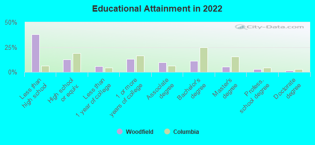
Education in this neighborhood (subdivision or community):
- Percentage of people 3 years and older in K-12 schools:
Woodfield: 34.8% Columbia: 12.2%
- Percentage of people 3 years and older in undergraduate colleges:
Woodfield: 7.6% Columbia: 16.2%
- Percentage of people 3 years and older in grad. or professional schools:
Woodfield: 6.7% Columbia: 3.5%
- Percentage of students K-12 enrolled in private schools:
Woodfield: 12.5% Columbia: 24.2%
Percentage of population below poverty level:
| Woodfield: | 21.7% |
| Columbia: | 20.7% |
Median year owner moved in (as recorded in 2022):
| Woodfield: | 2006 |
| Columbia: | 2013 |
Percentage of married-couple families with both working:
| Woodfield: | 129.8% |
| Columbia: | 72.3% |
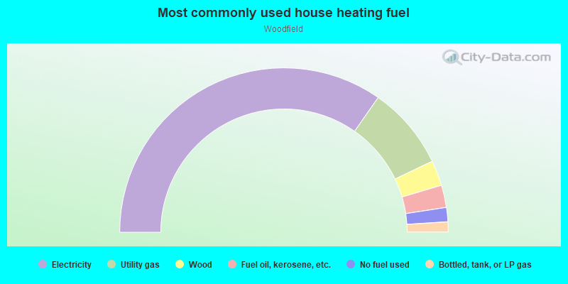
- 69.5%Electricity
- 16.4%Utility gas
- 5.0%Wood
- 4.4%Fuel oil, kerosene, etc.
- 2.8%No fuel used
- 2.0%Bottled, tank, or LP gas
Limited-access highways (interstate or state) in this neighborhood:
I- 77
Length: 1.98 miles
Directions: N-S, SW-NE
Directions: N-S, SW-NE
I- 20
Length: 1.80 miles
Directions: E-W, SE-NW, SW-NE
Directions: E-W, SE-NW, SW-NE
Highways in this neighborhood:
Percival Rd (State Hwy 12)
Length: 3.82 miles
Directions: E-W, SW-NE
Address range: 1001 to 2699
Directions: E-W, SW-NE
Address range: 1001 to 2699
Notch Rd (US Hwy 1, Two Notch Rd)
Length: 0.65 miles
Direction: SW-NE
Address range: 7338 to 7499
Direction: SW-NE
Address range: 7338 to 7499
Roads and streets:
Faraway Dr
Length: 2.67 miles
Directions: E-W, N-S, SW-NE
Address range: 1000 to 8399
Directions: E-W, N-S, SW-NE
Address range: 1000 to 8399
Hunt Club Rd
Length: 1.87 miles
Directions: E-W, SE-NW, SW-NE
Address range: 7201 to 8487
Directions: E-W, SE-NW, SW-NE
Address range: 7201 to 8487
Brookfield Rd
Length: 1.62 miles
Directions: E-W, N-S, SE-NW, SW-NE
Address range: 7000 to 8199
Directions: E-W, N-S, SE-NW, SW-NE
Address range: 7000 to 8199
Decker Blvd
Length: 1.47 miles
Direction: SE-NW
Address range: 1600 to 2834
Direction: SE-NW
Address range: 1600 to 2834
Cheltenham Ln
Length: 1.44 miles
Directions: E-W, N-S, SE-NW, SW-NE
Address range: 1400 to 2099
Directions: E-W, N-S, SE-NW, SW-NE
Address range: 1400 to 2099
Omega Dr
Length: 1.42 miles
Directions: E-W, N-S, SE-NW, SW-NE
Address range: 1000 to 2399
Directions: E-W, N-S, SE-NW, SW-NE
Address range: 1000 to 2399
Morninglo Ln
Length: 1.27 miles
Directions: E-W, N-S, SE-NW, SW-NE
Address range: 1600 to 2299
Directions: E-W, N-S, SE-NW, SW-NE
Address range: 1600 to 2299
I-20
Length: 1.24 miles
Direction: E-W
Direction: E-W
Trenholm Rd
Length: 1.17 miles
Directions: E-W, SW-NE
Directions: E-W, SW-NE
I-77
Length: 1.16 miles
Directions: N-S, SW-NE
Directions: N-S, SW-NE
Chatsworth Rd
Length: 1.14 miles
Directions: E-W, N-S, SE-NW, SW-NE
Address range: 2415 to 3199
Directions: E-W, N-S, SE-NW, SW-NE
Address range: 2415 to 3199
Drexel Lake Dr
Length: 0.99 miles
Directions: E-W, N-S, SE-NW, SW-NE
Address range: 1600 to 2099
Directions: E-W, N-S, SE-NW, SW-NE
Address range: 1600 to 2099
Fairlamb Ave
Length: 0.92 miles
Directions: N-S, SE-NW, SW-NE
Address range: 1600 to 2199
Directions: N-S, SE-NW, SW-NE
Address range: 1600 to 2199
Woodfield Dr
Length: 0.90 miles
Directions: E-W, N-S, SE-NW, SW-NE
Address range: 1700 to 2199
Directions: E-W, N-S, SE-NW, SW-NE
Address range: 1700 to 2199
E Boundary Rd
Length: 0.86 miles
Directions: E-W, N-S, SE-NW
Address range: 1800 to 2399
Directions: E-W, N-S, SE-NW
Address range: 1800 to 2399
Cermack St
Length: 0.84 miles
Directions: E-W, N-S, SE-NW, SW-NE
Address range: 1000 to 2241
Directions: E-W, N-S, SE-NW, SW-NE
Address range: 1000 to 2241
Overhill Rd
Length: 0.84 miles
Directions: N-S, SE-NW, SW-NE
Address range: 1600 to 2099
Directions: N-S, SE-NW, SW-NE
Address range: 1600 to 2099
Bywood Dr
Length: 0.84 miles
Directions: N-S, SE-NW
Address range: 1500 to 1999
Directions: N-S, SE-NW
Address range: 1500 to 1999
Long Shadow Ln
Length: 0.82 miles
Directions: E-W, N-S, SE-NW, SW-NE
Address range: 1600 to 2299
Directions: E-W, N-S, SE-NW, SW-NE
Address range: 1600 to 2299
Bay Springs Rd
Length: 0.81 miles
Directions: E-W, N-S, SE-NW, SW-NE
Address range: 7700 to 8299
Directions: E-W, N-S, SE-NW, SW-NE
Address range: 7700 to 8299
Nearview Ave
Length: 0.78 miles
Directions: E-W, N-S, SE-NW, SW-NE
Address range: 1700 to 1999
Directions: E-W, N-S, SE-NW, SW-NE
Address range: 1700 to 1999
Dupont Dr
Length: 0.78 miles
Directions: N-S, SE-NW
Address range: 1601 to 2199
Directions: N-S, SE-NW
Address range: 1601 to 2199
Alpine Rd
Length: 0.75 miles
Direction: SE-NW
Address range: 4719 to 4929
Direction: SE-NW
Address range: 4719 to 4929
O'Neil
Length: 0.75 miles
Directions: N-S, SE-NW, SW-NE
Directions: N-S, SE-NW, SW-NE
Exeter Ln
Length: 0.70 miles
Directions: E-W, N-S, SW-NE
Address range: 7700 to 8099
Directions: E-W, N-S, SW-NE
Address range: 7700 to 8099
Crestview Ave
Length: 0.69 miles
Directions: E-W, SW-NE
Address range: 1500 to 1899
Directions: E-W, SW-NE
Address range: 1500 to 1899
Castle Pinckney Rd
Length: 0.69 miles
Direction: E-W
Address range: 1000 to 1699
Direction: E-W
Address range: 1000 to 1699
Windsor Lake Blvd
Length: 0.63 miles
Directions: E-W, N-S, SE-NW, SW-NE
Address range: 8000 to 8673
Directions: E-W, N-S, SE-NW, SW-NE
Address range: 8000 to 8673
Old Percival Rd
Length: 0.63 miles
Direction: SW-NE
Address range: 7900 to 8099
Direction: SW-NE
Address range: 7900 to 8099
Springfield Ave
Length: 0.57 miles
Directions: E-W, N-S, SW-NE
Address range: 1700 to 1899
Directions: E-W, N-S, SW-NE
Address range: 1700 to 1899
Loch Ln
Length: 0.57 miles
Directions: E-W, N-S, SE-NW, SW-NE
Address range: 7701 to 8199
Directions: E-W, N-S, SE-NW, SW-NE
Address range: 7701 to 8199
Edgemore Rd
Length: 0.56 miles
Directions: E-W, N-S, SE-NW, SW-NE
Address range: 1600 to 2199
Directions: E-W, N-S, SE-NW, SW-NE
Address range: 1600 to 2199
Dartmoore Ln
Length: 0.55 miles
Directions: E-W, SW-NE
Address range: 7700 to 7934
Directions: E-W, SW-NE
Address range: 7700 to 7934
Berkshire Dr
Length: 0.52 miles
Directions: E-W, N-S, SE-NW, SW-NE
Address range: 300 to 799
Directions: E-W, N-S, SE-NW, SW-NE
Address range: 300 to 799
Wessex Ln
Length: 0.50 miles
Direction: E-W
Address range: 7700 to 7999
Direction: E-W
Address range: 7700 to 7999
Meredith Sq
Length: 0.48 miles
Directions: E-W, N-S, SE-NW
Address range: 100 to 399
Directions: E-W, N-S, SE-NW
Address range: 100 to 399
Castleton Ln
Length: 0.45 miles
Directions: E-W, SW-NE
Address range: 7700 to 7999
Directions: E-W, SW-NE
Address range: 7700 to 7999
Old Satchel Ford Rd
Length: 0.43 miles
Directions: E-W, N-S, SW-NE
Address range: 1001 to 8076
Directions: E-W, N-S, SW-NE
Address range: 1001 to 8076
Audubon Ave
Length: 0.40 miles
Directions: N-S, SE-NW
Address range: 1900 to 2241
Directions: N-S, SE-NW
Address range: 1900 to 2241
Kneece Rd
Length: 0.38 miles
Directions: E-W, N-S, SE-NW
Address range: 2300 to 2599
Directions: E-W, N-S, SE-NW
Address range: 2300 to 2599
Turnbridge Ln
Length: 0.37 miles
Directions: E-W, N-S, SE-NW
Address range: 7700 to 7999
Directions: E-W, N-S, SE-NW
Address range: 7700 to 7999
Ardmore Rd
Length: 0.36 miles
Directions: N-S, SE-NW, SW-NE
Address range: 1700 to 1899
Directions: N-S, SE-NW, SW-NE
Address range: 1700 to 1899
Windsor Point Rd
Length: 0.36 miles
Directions: E-W, N-S, SE-NW, SW-NE
Address range: 1 to 399
Directions: E-W, N-S, SE-NW, SW-NE
Address range: 1 to 399
Fox Trail Dr
Length: 0.35 miles
Directions: E-W, N-S, SE-NW, SW-NE
Address range: 1 to 99
Directions: E-W, N-S, SE-NW, SW-NE
Address range: 1 to 99
York House Rd
Length: 0.33 miles
Directions: E-W, N-S, SW-NE
Address range: 7400 to 7699
Directions: E-W, N-S, SW-NE
Address range: 7400 to 7699
Scotsman Dr
Length: 0.32 miles
Directions: E-W, N-S
Address range: 2900 to 3099
Directions: E-W, N-S
Address range: 2900 to 3099
Alpha Ct
Length: 0.32 miles
Directions: E-W, N-S, SE-NW, SW-NE
Address range: 1500 to 1798
Directions: E-W, N-S, SE-NW, SW-NE
Address range: 1500 to 1798
Larchmont Dr
Length: 0.30 miles
Directions: N-S, SE-NW
Address range: 1900 to 2039
Directions: N-S, SE-NW
Address range: 1900 to 2039
Wynnewood Rd
Length: 0.30 miles
Directions: E-W, SW-NE
Address range: 1500 to 1699
Directions: E-W, SW-NE
Address range: 1500 to 1699
Pennfield Dr
Length: 0.30 miles
Directions: E-W, N-S, SE-NW, SW-NE
Address range: 1700 to 1999
Directions: E-W, N-S, SE-NW, SW-NE
Address range: 1700 to 1999
Bagpipe Rd
Length: 0.29 miles
Directions: E-W, N-S, SE-NW, SW-NE
Address range: 2900 to 2999
Directions: E-W, N-S, SE-NW, SW-NE
Address range: 2900 to 2999
Wales St
Length: 0.27 miles
Directions: N-S, SE-NW
Address range: 2700 to 2899
Directions: N-S, SE-NW
Address range: 2700 to 2899
Quaker Rd
Length: 0.27 miles
Directions: E-W, N-S, SE-NW, SW-NE
Address range: 1800 to 1999
Directions: E-W, N-S, SE-NW, SW-NE
Address range: 1800 to 1999
Shelby Dr
Length: 0.27 miles
Directions: E-W, N-S, SE-NW, SW-NE
Address range: 1900 to 2099
Directions: E-W, N-S, SE-NW, SW-NE
Address range: 1900 to 2099
Windsor Cove
Length: 0.26 miles
Directions: E-W, N-S, SE-NW, SW-NE
Address range: 1 to 99
Directions: E-W, N-S, SE-NW, SW-NE
Address range: 1 to 99
Crofton Way
Length: 0.26 miles
Directions: E-W, N-S, SE-NW
Address range: 20 to 2538
Directions: E-W, N-S, SE-NW
Address range: 20 to 2538
Tarpon Springs Rd
Length: 0.26 miles
Directions: E-W, N-S, SE-NW, SW-NE
Address range: 100 to 399
Directions: E-W, N-S, SE-NW, SW-NE
Address range: 100 to 399
Quiet Ln
Length: 0.26 miles
Direction: E-W
Address range: 1000 to 1199
Direction: E-W
Address range: 1000 to 1199
Foxcroft Rd
Length: 0.26 miles
Directions: E-W, SW-NE
Address range: 1000 to 1199
Directions: E-W, SW-NE
Address range: 1000 to 1199
Coral Vine Ln
Length: 0.25 miles
Direction: E-W
Address range: 1000 to 1199
Direction: E-W
Address range: 1000 to 1199
Pontiac Dr
Length: 0.25 miles
Directions: N-S, SW-NE
Address range: 1900 to 1999
Directions: N-S, SW-NE
Address range: 1900 to 1999
Teakwood Ln
Length: 0.23 miles
Directions: E-W, SE-NW, SW-NE
Address range: 1600 to 1899
Directions: E-W, SE-NW, SW-NE
Address range: 1600 to 1899
Two Notch Rd (Us-1)
Length: 0.22 miles
Directions: N-S, SW-NE
Directions: N-S, SW-NE
Springbrook Rd
Length: 0.22 miles
Directions: E-W, N-S, SE-NW, SW-NE
Address range: 8000 to 8099
Directions: E-W, N-S, SE-NW, SW-NE
Address range: 8000 to 8099
Moolah Dr
Length: 0.22 miles
Directions: N-S, SE-NW, SW-NE
Address range: 100 to 127
Directions: N-S, SE-NW, SW-NE
Address range: 100 to 127
Cullasaja Cir
Length: 0.21 miles
Directions: E-W, N-S, SE-NW, SW-NE
Address range: 1100 to 1199
Directions: E-W, N-S, SE-NW, SW-NE
Address range: 1100 to 1199
Decker Park Rd
Length: 0.21 miles
Directions: E-W, SW-NE
Address range: 100 to 199
Directions: E-W, SW-NE
Address range: 100 to 199
Roxboro Dr
Length: 0.21 miles
Directions: E-W, SW-NE
Address range: 1900 to 1999
Directions: E-W, SW-NE
Address range: 1900 to 1999
Robins Nest Rd
Length: 0.21 miles
Direction: E-W
Address range: 1100 to 1199
Direction: E-W
Address range: 1100 to 1199
McNaughton Dr
Length: 0.20 miles
Directions: E-W, N-S, SE-NW, SW-NE
Address range: 3000 to 3099
Directions: E-W, N-S, SE-NW, SW-NE
Address range: 3000 to 3099
Red Oak Rd
Length: 0.20 miles
Direction: SE-NW
Address range: 2300 to 2399
Direction: SE-NW
Address range: 2300 to 2399
Locust Rd
Length: 0.20 miles
Direction: SE-NW
Address range: 2300 to 2399
Direction: SE-NW
Address range: 2300 to 2399
White Pine Rd
Length: 0.20 miles
Direction: SE-NW
Address range: 2300 to 2399
Direction: SE-NW
Address range: 2300 to 2399
Oakcrest Rd
Length: 0.20 miles
Direction: SE-NW
Address range: 2300 to 2399
Direction: SE-NW
Address range: 2300 to 2399
Wellbrook Rd
Length: 0.19 miles
Directions: N-S, SE-NW
Address range: 2300 to 2399
Directions: N-S, SE-NW
Address range: 2300 to 2399
Woodstock Dr
Length: 0.19 miles
Direction: E-W
Address range: 2000 to 2099
Direction: E-W
Address range: 2000 to 2099
Willoby St
Length: 0.19 miles
Directions: N-S, SE-NW
Address range: 1616 to 1859
Directions: N-S, SE-NW
Address range: 1616 to 1859
Fieldwood Dr
Length: 0.18 miles
Directions: E-W, SE-NW
Address range: 2000 to 2198
Directions: E-W, SE-NW
Address range: 2000 to 2198
Hillandale Rd
Length: 0.18 miles
Directions: N-S, SE-NW
Address range: 1600 to 1699
Directions: N-S, SE-NW
Address range: 1600 to 1699
Palisades Cir
Length: 0.18 miles
Directions: E-W, N-S, SE-NW, SW-NE
Address range: 1100 to 1199
Directions: E-W, N-S, SE-NW, SW-NE
Address range: 1100 to 1199
Worthing Pl
Length: 0.18 miles
Directions: N-S, SE-NW
Directions: N-S, SE-NW
Hunt Club Forrest Rd
Length: 0.18 miles
Directions: E-W, N-S, SE-NW, SW-NE
Directions: E-W, N-S, SE-NW, SW-NE
Lilac Ln
Length: 0.17 miles
Directions: N-S, SE-NW, SW-NE
Address range: 1600 to 1699
Directions: N-S, SE-NW, SW-NE
Address range: 1600 to 1699
Brookhirst Ct
Length: 0.15 miles
Direction: SE-NW
Address range: 1500 to 1599
Direction: SE-NW
Address range: 1500 to 1599
Malton Pl
Length: 0.15 miles
Directions: N-S, SE-NW
Directions: N-S, SE-NW
Moorland Dr
Length: 0.15 miles
Directions: E-W, N-S, SE-NW
Address range: 2900 to 2935
Directions: E-W, N-S, SE-NW
Address range: 2900 to 2935
Old Field Rd
Length: 0.14 miles
Directions: E-W, SW-NE
Address range: 2200 to 2399
Directions: E-W, SW-NE
Address range: 2200 to 2399
Welch Rd
Length: 0.14 miles
Directions: E-W, N-S, SE-NW
Address range: 2700 to 2899
Directions: E-W, N-S, SE-NW
Address range: 2700 to 2899
Leabrook Rd (Windsor Lake Blvd)
Length: 0.14 miles
Directions: E-W, SE-NW
Address range: 7900 to 8499
Directions: E-W, SE-NW
Address range: 7900 to 8499
Friar Pl
Length: 0.14 miles
Directions: E-W, N-S, SE-NW, SW-NE
Directions: E-W, N-S, SE-NW, SW-NE
Brookfield Heights Rd
Length: 0.13 miles
Direction: SE-NW
Direction: SE-NW
Willoby St (Willoby Ln)
Length: 0.12 miles
Direction: SE-NW
Address range: 1600 to 1615
Direction: SE-NW
Address range: 1600 to 1615
Gavin Dr
Length: 0.11 miles
Directions: N-S, SE-NW
Address range: 2300 to 2399
Directions: N-S, SE-NW
Address range: 2300 to 2399
Foxborough Rd
Length: 0.10 miles
Directions: E-W, N-S, SW-NE
Directions: E-W, N-S, SW-NE
London Ln
Length: 0.10 miles
Direction: N-S
Address range: 2500 to 2599
Direction: N-S
Address range: 2500 to 2599
Harvest Hill Rd
Length: 0.09 miles
Direction: SE-NW
Address range: 2000 to 2099
Direction: SE-NW
Address range: 2000 to 2099
Ithan Cir
Length: 0.09 miles
Directions: E-W, SE-NW
Address range: 1 to 99
Directions: E-W, SE-NW
Address range: 1 to 99
Misty Oak Rd
Length: 0.08 miles
Directions: N-S, SE-NW, SW-NE
Address range: 100 to 135
Directions: N-S, SE-NW, SW-NE
Address range: 100 to 135
Addington Rd
Length: 0.08 miles
Directions: N-S, SE-NW, SW-NE
Address range: 2301 to 2307
Directions: N-S, SE-NW, SW-NE
Address range: 2301 to 2307
Foxhound Ct
Length: 0.07 miles
Direction: E-W
Direction: E-W
Hunt End Ct
Length: 0.07 miles
Direction: E-W
Direction: E-W
Valley Park Rd
Length: 0.07 miles
Directions: E-W, SE-NW
Address range: 2200 to 2299
Directions: E-W, SE-NW
Address range: 2200 to 2299
Brookfield Heights Ct
Length: 0.07 miles
Direction: E-W
Address range: 1 to 99
Direction: E-W
Address range: 1 to 99
Hunt Club Forest Dr
Length: 0.06 miles
Direction: SE-NW
Direction: SE-NW
Boyden Arbor Rd
Length: 0.05 miles
Direction: SE-NW
Direction: SE-NW
Sigma Ct
Length: 0.05 miles
Direction: E-W
Address range: 1600 to 1699
Direction: E-W
Address range: 1600 to 1699
Epsilon Ct
Length: 0.05 miles
Direction: E-W
Address range: 1600 to 1699
Direction: E-W
Address range: 1600 to 1699
Conestoga Cir
Length: 0.05 miles
Direction: E-W
Address range: 1600 to 1699
Direction: E-W
Address range: 1600 to 1699
Niblick Ct
Length: 0.04 miles
Direction: SE-NW
Address range: 1 to 99
Direction: SE-NW
Address range: 1 to 99
Sewick Cir
Length: 0.04 miles
Direction: E-W
Address range: 1 to 99
Direction: E-W
Address range: 1 to 99
Norwich Ct
Length: 0.04 miles
Direction: SE-NW
Direction: SE-NW
Valley Stream Rd
Length: 0.04 miles
Direction: N-S
Direction: N-S
St George St
Length: 0.03 miles
Direction: SE-NW
Address range: 1900 to 1999
Direction: SE-NW
Address range: 1900 to 1999
N Cross Ct
Length: 0.03 miles
Direction: N-S
Address range: 1 to 35
Direction: N-S
Address range: 1 to 35
St Anthony Rd
Length: 0.03 miles
Direction: SE-NW
Address range: 1900 to 1999
Direction: SE-NW
Address range: 1900 to 1999
Red Fox Ct
Length: 0.03 miles
Direction: E-W
Direction: E-W
Cheshire Ct
Length: 0.03 miles
Direction: N-S
Direction: N-S
Loch Lane Cir
Length: 0.03 miles
Direction: N-S
Address range: 7800 to 7899
Direction: N-S
Address range: 7800 to 7899
Wellington Rd
Length: 0.02 miles
Direction: E-W
Direction: E-W
S-40-2090
Length: 0.02 miles
Direction: SE-NW
Direction: SE-NW
Railroad features:
Csx RR
Length: 0.90 miles
Direction: SW-NE
Direction: SW-NE
Other features:
Knot Br
Length: 0.62 miles
Directions: E-W, N-S, SE-NW, SW-NE
Directions: E-W, N-S, SE-NW, SW-NE