West Sahara neighborhood in Las Vegas, Nevada (NV), 89117 detailed profile
Settings
X

Business Search - 14 Million verified businesses
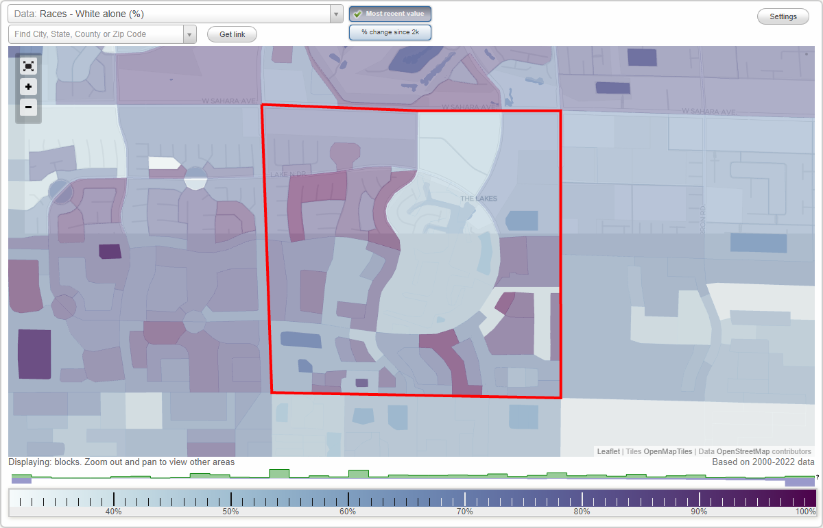
Area: 1.027 square miles
Population: 8,379
Population density:
| West Sahara: | 8,159 people per square mile |
| Las Vegas: | 5,792 people per square mile |

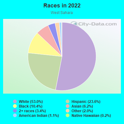
- 4,59753.0%White
- 2,04923.6%Hispanic or Latino
- 90010.4%Black
- 5386.2%Asian
- 2943.4%Two or more races
- 1762.0%Some other race
- 951.1%American Indian
- 170.2%Native Hawaiian and Other
Pacific Islander
Distribution of median household income
![Distribution of median household income]()
- 269Less than $10,000
- 270$10,000 to $19,999
- 466$20,000 to $29,999
- 318$30,000 to $39,999
- 515$40,000 to $49,999
- 322$50,000 to $59,999
- 336$60,000 to $74,999
- 511$75,000 to $99,999
- 481$100,000 to $124,999
- 151$125,000 to $149,999
- 232$150,000 to $199,999
- 255$200,000 or more

Distribution of owner-occupied house/condo value
![Distribution of owner-occupied house/condo value]()
- 350Less than $50,000
- 172$50,000 to $99,999
- 39$100,000 to $149,999
- 642$150,000 to $199,999
- 108$200,000 to $249,999
- 235$250,000 to $299,999
- 387$300,000 to $399,999
- 494$400,000 to $499,999
- 352$500,000 to $749,999
- 68$750,000 to $999,999
- 258$1,000,000 or more

Distribution of rent paid by renters
![Distribution of rent paid by renters]()
- 18$400 to $499
- 21$500 to $599
- 142$600 to $699
- 225$700 to $799
- 103$800 to $899
- 68$900 to $999
- 1,086$1,000 to $1,249
- 646$1,250 to $1,499
- 499$1,500 to $1,999
- 562$2,000 or more

| Males: | 4,167 |
| Females: | 4,211 |
Males:
| This neighborhood: | 41.0 years |
| Whole city: | 38.4 years |
| This neighborhood: | 42.7 years |
| Whole city: | 38.9 years |
Average household size:
| West Sahara: | 9.0 people |
| Las Vegas: | 2.7 people |
Percentage of family households:
| West Sahara: | 36.1% |
| Las Vegas: | 45.8% |
| Here: | 35.7% |
| Las Vegas: | 40.9% |
Percentage of married-couple families with children (among all households):
| West Sahara: | 21.6% |
| Las Vegas: | 23.4% |
Percentage of single-mother households (among all households):
| West Sahara: | 24.6% |
| Las Vegas: | 10.1% |
Percentage of never married males 15 years old and over:
Percentage of never married females 15 years old and over:
| West Sahara: | 20.9% |
| Las Vegas: | 19.7% |
Percentage of never married females 15 years old and over:
| West Sahara: | 16.6% |
| city: | 17.0% |
Percentage of people that speak English not well or not at all:
| West Sahara: | 1.3% |
| Las Vegas: | 7.0% |
Percentage of people born in this state:
Percentage of people born in another U.S. state:
Percentage of native residents but born outside the U.S.:
Percentage of foreign born residents:
| Here: | 26.5% |
| Las Vegas: | 27.3% |
Percentage of people born in another U.S. state:
| West Sahara: | 53.4% |
| Las Vegas: | 49.8% |
Percentage of native residents but born outside the U.S.:
| Here: | 0.6% |
| city: | 1.9% |
Percentage of foreign born residents:
| Here: | 19.5% |
| Las Vegas: | 21.0% |
Owner-occupied
Renter-occupied

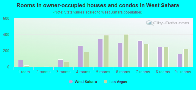
- Rooms in owner-occupied houses and condos in West Sahara
- 881 room
- 02 rooms
- 913 rooms
- 2624 rooms
- 3485 rooms
- 3016 rooms
- 3267 rooms
- 2478 rooms
- 1629+ rooms
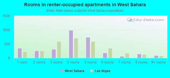
- Rooms in renter-occupied apartments in West Sahara
- 3481 room
- 2622 rooms
- 3133 rooms
- 9884 rooms
- 7375 rooms
- 1826 rooms
- 667 rooms
- 1458 rooms
- 949+ rooms
Owner-occupied
Renter-occupied
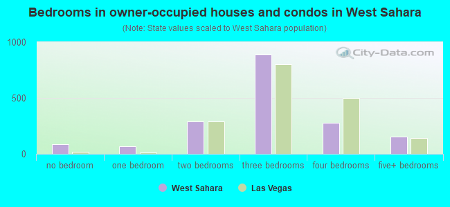
- Bedrooms in owner-occupied houses and condos in West Sahara
- 88no bedroom
- 651 bedroom
- 2882 bedrooms
- 8903 bedrooms
- 2784 bedrooms
- 1525+ bedrooms
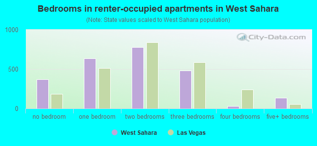
- Bedrooms in renter-occupied apartments in West Sahara
- 372no bedroom
- 6371 bedroom
- 7772 bedrooms
- 4803 bedrooms
- 294 bedrooms
- 1335+ bedrooms
Average number of cars or other vehicles available in houses/condos:
Average number of cars or other vehicles available in apartments:
| This neighborhood: | 1.6 |
| Las Vegas: | 2.0 |
Average number of cars or other vehicles available in apartments:
| Here: | 1.5 |
| city: | 1.3 |
Percentage of units with a mortgage:
| West Sahara: | 71.4% |
| Las Vegas: | 69.3% |
Average estimated value of detached houses in 2022 (42.4% of all units):
| West Sahara: | $394,434 |
| Nevada: | $549,327 |
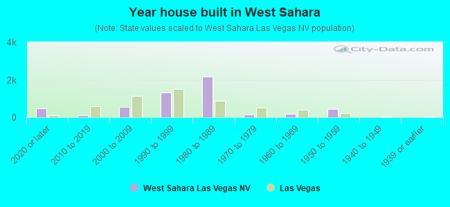
- Year house built in West Sahara
- 4832020 or later
- 1082010 to 2019
- 5592000 to 2009
- 1,3101990 to 1999
- 2,1771980 to 1989
- 1361970 to 1979
- 1811960 to 1969
- 4341950 to 1959
- 01940 to 1949
- 01939 or earlier
City-data.com crime index for city in 2020 (higher means more crime):
| City: | 280.7 |
| U.S. average: | 219.5 |
Travel time to work (commute)
![Travel time to work (commute)]()
- 33Less than 5 minutes
- 4605 to 9 minutes
- 25010 to 14 minutes
- 54115 to 19 minutes
- 76420 to 24 minutes
- 48725 to 29 minutes
- 83530 to 34 minutes
- 22535 to 39 minutes
- 6640 to 44 minutes
- 25345 to 59 minutes
- 8760 to 89 minutes
- 3790 or more minutes

Means of transportation to work
![Means of transportation to work]()
- 79.5%3,127Drove a car alone
- 7.3%287Carpooled
- 5.6%222Bus
- 0.3%12Taxi
- 1.2%49Other means
- 11.2%439Worked at home

Time leaving home to go to work
![Time leaving home to go to work]()
- 20312:00 a.m. to 4:59 a.m.
- 1045:00 a.m. to 5:29 a.m.
- 415:30 a.m. to 5:59 a.m.
- 1506:00 a.m. to 6:29 a.m.
- 1246:30 a.m. to 6:59 a.m.
- 5717:00 a.m. to 7:29 a.m.
- 3217:30 a.m. to 7:59 a.m.
- 4018:00 a.m. to 8:29 a.m.
- 438:30 a.m. to 8:59 a.m.
- 2009:00 a.m. to 9:59 a.m.
- 35510:00 a.m. to 10:59 a.m.
- 10211:00 a.m. to 11:59 a.m.
- 35912:00 p.m. to 3:59 p.m.
- 6634:00 p.m. to 11:59 p.m.

Occupations of males:
- Percentage of males in management occupations (except farmers):
Here: 7.1% city: 9.6%
- Percentage of males in business and financial operations occupations:
Here: 3.3% city: 3.6%
- Percentage of males in computer and mathematical occupations:
Here: 2.3% city: 3.4%
- Percentage of males in education, training, and library occupations:
Here: 1.7% city: 2.5%
- Percentage of males in arts, design, entertainment, sports, and media occupations:
Here: 5.2% city: 2.5%
- Percentage of males in healthcare practitioners and technical occupations:
Here: 2.8% city: 3.3%
- Percentage of males in service occupations:
Here: 16.0% city: 23.3%
- Percentage of males in sales and office occupations:
Here: 26.7% city: 16.6%
- Percentage of males in construction, extraction, and maintenance occupations:
Here: 2.3% city: 10.6%
- Percentage of males in production occupations:
Here: 2.7% city: 3.3%
- Percentage of males in transportation occupations:
Here: 13.1% city: 6.6%
- Percentage of males in material moving occupations:
Here: 9.3% city: 5.4%
Occupations of females:
- Percentage of females in management occupations (except farmers):
Here: 9.3% city: 8.5%
- Percentage of females in business and financial operations occupations:
Here: 6.6% city: 5.7%
- Percentage of females in life, physical, and social science occupations:
Here: 2.0% city: 0.4%
- Percentage of females in education, training, and library occupations:
Here: 7.9% city: 8.0%
- Percentage of females in arts, design, entertainment, sports, and media occupations:
Here: 4.4% city: 1.8%
- Percentage of females in healthcare practitioners and technical occupations:
Here: 4.7% city: 7.4%
- Percentage of females in service occupations:
Here: 23.2% city: 26.5%
- Percentage of females in sales and office occupations:
Here: 37.4% city: 30.5%
- Percentage of females in production occupations:
Here: 2.6% city: 1.8%
Percentage of people 16-64 in Armed Forces:
| West Sahara: | 0.2% |
| Las Vegas: | 1.0% |
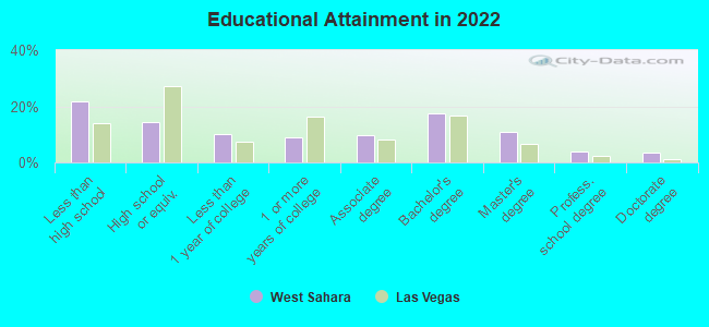
Education in this neighborhood (subdivision or community):
- Percentage of people 3 years and older in K-12 schools:
West Sahara: 17.1% Las Vegas: 17.4%
- Percentage of people 3 years and older in undergraduate colleges:
West Sahara: 3.1% Las Vegas: 4.2%
- Percentage of people 3 years and older in grad. or professional schools:
West Sahara: 2.7% Las Vegas: 1.0%
- Percentage of students K-12 enrolled in private schools:
West Sahara: 59.2% Las Vegas: 12.9%
Percentage of population below poverty level:
| West Sahara: | 18.4% |
| Las Vegas: | 14.1% |
Median year owner moved in (as recorded in 2022):
| West Sahara: | 2008 |
| Las Vegas: | 2015 |
Percentage of married-couple families with both working:
| West Sahara: | 69.4% |
| Las Vegas: | 62.0% |
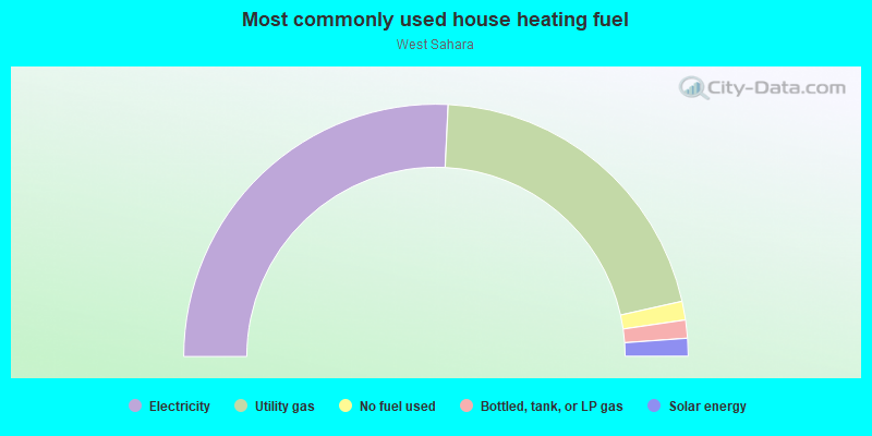
- 51.5%Electricity
- 41.4%Utility gas
- 2.4%No fuel used
- 2.3%Bottled, tank, or LP gas
- 2.3%Solar energy
Roads and streets:
Lake East Dr
Length: 1.18 miles
Directions: E-W, N-S, SE-NW, SW-NE
Address range: 2800 to 3271
Directions: E-W, N-S, SE-NW, SW-NE
Address range: 2800 to 3271
Crystal Water Way
Length: 0.97 miles
Directions: N-S, SE-NW, SW-NE
Address range: 2700 to 3399
Directions: N-S, SE-NW, SW-NE
Address range: 2700 to 3399
Lake South Dr
Length: 0.73 miles
Direction: E-W
Address range: 3272 to 9099
Direction: E-W
Address range: 3272 to 9099
Desert Inn Rd (W Desert Inn Rd)
Length: 0.69 miles
Direction: E-W
Address range: 9025 to 9249
Direction: E-W
Address range: 9025 to 9249
Lake North Dr
Length: 0.58 miles
Direction: E-W
Address range: 8800 to 9199
Direction: E-W
Address range: 8800 to 9199
S Durango Dr
Length: 0.57 miles
Direction: N-S
Address range: 2606 to 3299
Direction: N-S
Address range: 2606 to 3299
Waterview Dr
Length: 0.55 miles
Directions: N-S, SW-NE
Address range: 2800 to 3198
Directions: N-S, SW-NE
Address range: 2800 to 3198
Mariner Cove Dr
Length: 0.52 miles
Direction: E-W
Address range: 9000 to 9099
Direction: E-W
Address range: 9000 to 9099
Coast Line Ct
Length: 0.35 miles
Directions: E-W, N-S, SE-NW, SW-NE
Address range: 2800 to 2999
Directions: E-W, N-S, SE-NW, SW-NE
Address range: 2800 to 2999
Citicorp Dr
Length: 0.35 miles
Directions: E-W, SE-NW
Address range: 8700 to 8799
Directions: E-W, SE-NW
Address range: 8700 to 8799
Waterside Cir
Length: 0.35 miles
Directions: E-W, N-S, SE-NW, SW-NE
Address range: 3000 to 3199
Directions: E-W, N-S, SE-NW, SW-NE
Address range: 3000 to 3199
Beach View Ct (Beach Vw)
Length: 0.30 miles
Directions: E-W, N-S, SE-NW, SW-NE
Address range: 3000 to 8799
Directions: E-W, N-S, SE-NW, SW-NE
Address range: 3000 to 8799
Donnegal Bay Dr
Length: 0.28 miles
Direction: N-S
Direction: N-S
Crystal Bay Dr
Length: 0.27 miles
Directions: N-S, SE-NW, SW-NE
Address range: 2800 to 2999
Directions: N-S, SE-NW, SW-NE
Address range: 2800 to 2999
Starboard Dr
Length: 0.27 miles
Direction: E-W
Address range: 8604 to 8698
Direction: E-W
Address range: 8604 to 8698
Country Vista Way
Length: 0.25 miles
Directions: E-W, SW-NE
Address range: 8800 to 8899
Directions: E-W, SW-NE
Address range: 8800 to 8899
Mariner Bay (Mariner Bay St, Mariner Bay Rd)
Length: 0.25 miles
Directions: N-S, SE-NW
Address range: 3200 to 3350
Directions: N-S, SE-NW
Address range: 3200 to 3350
Cantavo Dr
Length: 0.24 miles
Direction: N-S
Direction: N-S
Shannon River Dr
Length: 0.23 miles
Direction: N-S
Direction: N-S
Harborside Dr
Length: 0.23 miles
Directions: N-S, SW-NE
Address range: 3000 to 3199
Directions: N-S, SW-NE
Address range: 3000 to 3199
Ivory Coast Dr
Length: 0.21 miles
Directions: N-S, SE-NW, SW-NE
Address range: 3100 to 3298
Directions: N-S, SE-NW, SW-NE
Address range: 3100 to 3298
Yankee Clipper Dr
Length: 0.21 miles
Directions: E-W, N-S, SE-NW, SW-NE
Address range: 3000 to 8798
Directions: E-W, N-S, SE-NW, SW-NE
Address range: 3000 to 8798
Cutty Sark St
Length: 0.21 miles
Directions: E-W, N-S, SE-NW
Address range: 3200 to 3399
Directions: E-W, N-S, SE-NW
Address range: 3200 to 3399
Cristobal Way
Length: 0.21 miles
Directions: N-S, SW-NE
Address range: 3100 to 3218
Directions: N-S, SW-NE
Address range: 3100 to 3218
Shoreline Dr
Length: 0.21 miles
Directions: N-S, SE-NW
Address range: 3200 to 3399
Directions: N-S, SE-NW
Address range: 3200 to 3399
Grey Dolphin Dr
Length: 0.20 miles
Directions: N-S, SE-NW
Address range: 3200 to 3399
Directions: N-S, SE-NW
Address range: 3200 to 3399
High Sail Ct
Length: 0.20 miles
Directions: E-W, N-S, SE-NW, SW-NE
Address range: 2800 to 2899
Directions: E-W, N-S, SE-NW, SW-NE
Address range: 2800 to 2899
Coral Harbor Dr
Length: 0.20 miles
Directions: N-S, SE-NW
Address range: 3200 to 3399
Directions: N-S, SE-NW
Address range: 3200 to 3399
Clear Blue Dr
Length: 0.19 miles
Directions: E-W, SW-NE
Address range: 8801 to 8999
Directions: E-W, SW-NE
Address range: 8801 to 8999
Gentle Rain Way
Length: 0.19 miles
Direction: E-W
Address range: 9001 to 9099
Direction: E-W
Address range: 9001 to 9099
Whispering Wind Dr
Length: 0.19 miles
Direction: N-S
Address range: 2800 to 2999
Direction: N-S
Address range: 2800 to 2999
Sail Bay Dr
Length: 0.19 miles
Directions: E-W, SE-NW
Address range: 8800 to 8999
Directions: E-W, SE-NW
Address range: 8800 to 8999
Buttercreek Way
Length: 0.19 miles
Directions: E-W, SE-NW
Address range: 8600 to 8698
Directions: E-W, SE-NW
Address range: 8600 to 8698
W Catalonia Dr
Length: 0.19 miles
Directions: E-W, SW-NE
Address range: 8600 to 8675
Directions: E-W, SW-NE
Address range: 8600 to 8675
Freeport Ln
Length: 0.18 miles
Directions: E-W, SW-NE
Address range: 8600 to 8699
Directions: E-W, SW-NE
Address range: 8600 to 8699
Sandy Shores Dr
Length: 0.18 miles
Directions: E-W, SW-NE
Address range: 9000 to 9299
Directions: E-W, SW-NE
Address range: 9000 to 9299
Trafalgar Dr
Length: 0.18 miles
Directions: E-W, SE-NW
Address range: 8600 to 8699
Directions: E-W, SE-NW
Address range: 8600 to 8699
Quiet Cove Way
Length: 0.17 miles
Direction: E-W
Address range: 9000 to 9199
Direction: E-W
Address range: 9000 to 9199
Misty Harbour Dr
Length: 0.17 miles
Directions: E-W, N-S, SE-NW, SW-NE
Address range: 3000 to 3099
Directions: E-W, N-S, SE-NW, SW-NE
Address range: 3000 to 3099
Cypress Point Way (Cypress Point Rd)
Length: 0.17 miles
Directions: E-W, SE-NW
Address range: 9000 to 9126
Directions: E-W, SE-NW
Address range: 9000 to 9126
Mediterranean Dr (Mediterranean Vw)
Length: 0.16 miles
Directions: N-S, SW-NE
Address range: 3100 to 3199
Directions: N-S, SW-NE
Address range: 3100 to 3199
Beach Front Dr
Length: 0.16 miles
Direction: E-W
Address range: 8800 to 8999
Direction: E-W
Address range: 8800 to 8999
Carlitas Joy (Carlitas Joy Ct)
Length: 0.16 miles
Directions: E-W, N-S, SE-NW
Address range: 8700 to 8781
Directions: E-W, N-S, SE-NW
Address range: 8700 to 8781
Pleasant Lake Dr
Length: 0.15 miles
Directions: N-S, SW-NE
Address range: 2900 to 2999
Directions: N-S, SW-NE
Address range: 2900 to 2999
Country Scene Way
Length: 0.15 miles
Directions: E-W, SW-NE
Address range: 8800 to 8999
Directions: E-W, SW-NE
Address range: 8800 to 8999
Captains Pl
Length: 0.15 miles
Directions: E-W, N-S, SE-NW, SW-NE
Address range: 8700 to 8799
Directions: E-W, N-S, SE-NW, SW-NE
Address range: 8700 to 8799
Anchor Point Rd (Anchor Point Ave)
Length: 0.15 miles
Directions: E-W, SW-NE
Address range: 8747 to 8751
Directions: E-W, SW-NE
Address range: 8747 to 8751
Beluga Way
Length: 0.15 miles
Direction: E-W
Address range: 8700 to 8799
Direction: E-W
Address range: 8700 to 8799
Island View Ct
Length: 0.14 miles
Directions: E-W, N-S, SW-NE
Address range: 3000 to 3099
Directions: E-W, N-S, SW-NE
Address range: 3000 to 3099
Clamdigger Ln
Length: 0.14 miles
Directions: N-S, SW-NE
Address range: 3001 to 3199
Directions: N-S, SW-NE
Address range: 3001 to 3199
Lido Isle Ct
Length: 0.14 miles
Directions: E-W, N-S, SE-NW, SW-NE
Address range: 3100 to 3199
Directions: E-W, N-S, SE-NW, SW-NE
Address range: 3100 to 3199
Toscana Ln
Length: 0.13 miles
Directions: E-W, SE-NW
Address range: 8600 to 8699
Directions: E-W, SE-NW
Address range: 8600 to 8699
Portofino Ct
Length: 0.13 miles
Direction: E-W
Address range: 8600 to 8699
Direction: E-W
Address range: 8600 to 8699
Scenic Harbor Dr
Length: 0.12 miles
Direction: E-W
Address range: 8801 to 8911
Direction: E-W
Address range: 8801 to 8911
Harbor Vista St
Length: 0.12 miles
Directions: N-S, SE-NW
Address range: 3200 to 3299
Directions: N-S, SE-NW
Address range: 3200 to 3299
Rocky Shore Dr
Length: 0.12 miles
Directions: E-W, SE-NW, SW-NE
Address range: 8800 to 8919
Directions: E-W, SE-NW, SW-NE
Address range: 8800 to 8919
Ferrin Rd
Length: 0.12 miles
Directions: N-S, SE-NW, SW-NE
Address range: 2700 to 2799
Directions: N-S, SE-NW, SW-NE
Address range: 2700 to 2799
Surf View Dr
Length: 0.12 miles
Directions: E-W, SW-NE
Directions: E-W, SW-NE
Crystal Pool Dr (Crystal Pool Way)
Length: 0.12 miles
Directions: N-S, SE-NW
Address range: 3200 to 3264
Directions: N-S, SE-NW
Address range: 3200 to 3264
Lodestone Dr
Length: 0.12 miles
Directions: N-S, SE-NW, SW-NE
Address range: 2700 to 2799
Directions: N-S, SE-NW, SW-NE
Address range: 2700 to 2799
Canyon Rim Way
Length: 0.11 miles
Direction: E-W
Address range: 8800 to 8899
Direction: E-W
Address range: 8800 to 8899
Soft Sand Dr
Length: 0.11 miles
Direction: E-W
Address range: 9001 to 9099
Direction: E-W
Address range: 9001 to 9099
Walnut Knolls Way
Length: 0.11 miles
Direction: E-W
Address range: 8900 to 9099
Direction: E-W
Address range: 8900 to 9099
Barbuda (Barbuda Rd)
Length: 0.11 miles
Directions: N-S, SE-NW
Address range: 3200 to 3299
Directions: N-S, SE-NW
Address range: 3200 to 3299
Caribbean Ct
Length: 0.11 miles
Direction: E-W
Address range: 8600 to 8699
Direction: E-W
Address range: 8600 to 8699
Montego Bay Dr
Length: 0.11 miles
Direction: E-W
Address range: 8800 to 8999
Direction: E-W
Address range: 8800 to 8999
Coast Walk Cir
Length: 0.11 miles
Directions: E-W, SE-NW
Address range: 8900 to 8999
Directions: E-W, SE-NW
Address range: 8900 to 8999
Feather River Ct
Length: 0.11 miles
Direction: E-W
Address range: 9000 to 9099
Direction: E-W
Address range: 9000 to 9099
Bodega Bay St
Length: 0.10 miles
Directions: N-S, SW-NE
Address range: 3000 to 3099
Directions: N-S, SW-NE
Address range: 3000 to 3099
Newport Isle Ct
Length: 0.10 miles
Directions: E-W, SE-NW, SW-NE
Address range: 8700 to 8799
Directions: E-W, SE-NW, SW-NE
Address range: 8700 to 8799
Nigul Way
Length: 0.10 miles
Direction: N-S
Address range: 3330 to 3399
Direction: N-S
Address range: 3330 to 3399
Morningstar Ln
Length: 0.10 miles
Direction: E-W
Address range: 8600 to 8699
Direction: E-W
Address range: 8600 to 8699
Lake Sahara Dr
Length: 0.10 miles
Direction: SW-NE
Address range: 2700 to 2799
Direction: SW-NE
Address range: 2700 to 2799
Port Side Dr
Length: 0.09 miles
Direction: N-S
Address range: 3100 to 3143
Direction: N-S
Address range: 3100 to 3143
Crystal Cove Dr
Length: 0.09 miles
Directions: E-W, N-S, SE-NW
Address range: 2800 to 2899
Directions: E-W, N-S, SE-NW
Address range: 2800 to 2899
Chapel Pines Ln
Length: 0.09 miles
Direction: N-S
Address range: 3200 to 3399
Direction: N-S
Address range: 3200 to 3399
Sky Country Ln
Length: 0.09 miles
Directions: N-S, SE-NW
Address range: 3318 to 3399
Directions: N-S, SE-NW
Address range: 3318 to 3399
Antioch Way
Length: 0.09 miles
Direction: E-W
Address range: 8900 to 8999
Direction: E-W
Address range: 8900 to 8999
Crystal Glass Dr
Length: 0.09 miles
Directions: E-W, SE-NW
Address range: 9000 to 9099
Directions: E-W, SE-NW
Address range: 9000 to 9099
Shoreheight St
Length: 0.09 miles
Directions: N-S, SE-NW, SW-NE
Address range: 3200 to 3299
Directions: N-S, SE-NW, SW-NE
Address range: 3200 to 3299
Malibu Vista St
Length: 0.09 miles
Directions: N-S, SE-NW
Address range: 3200 to 3299
Directions: N-S, SE-NW
Address range: 3200 to 3299
Tidewater Ct
Length: 0.09 miles
Directions: N-S, SE-NW
Address range: 2700 to 2799
Directions: N-S, SE-NW
Address range: 2700 to 2799
Nautical Bay Ln (Nautical Bay Rd)
Length: 0.09 miles
Direction: E-W
Address range: 8701 to 8723
Direction: E-W
Address range: 8701 to 8723
Leeward Dr
Length: 0.09 miles
Direction: E-W
Direction: E-W
Brookstone Ct
Length: 0.09 miles
Direction: N-S
Address range: 2700 to 2799
Direction: N-S
Address range: 2700 to 2799
Century Oaks Ln
Length: 0.08 miles
Direction: N-S
Direction: N-S
Cherry Springs Ct
Length: 0.08 miles
Direction: N-S
Address range: 2700 to 2799
Direction: N-S
Address range: 2700 to 2799
Baycliff Ct
Length: 0.08 miles
Directions: E-W, N-S, SW-NE
Address range: 2700 to 2799
Directions: E-W, N-S, SW-NE
Address range: 2700 to 2799
Otter Creek Ct
Length: 0.08 miles
Directions: N-S, SW-NE
Address range: 2700 to 2799
Directions: N-S, SW-NE
Address range: 2700 to 2799
Moss Creek Cir
Length: 0.08 miles
Direction: E-W
Address range: 9000 to 9026
Direction: E-W
Address range: 9000 to 9026
Elk Grove Way
Length: 0.08 miles
Direction: E-W
Address range: 8800 to 8899
Direction: E-W
Address range: 8800 to 8899
Sonterra Cir
Length: 0.08 miles
Direction: N-S
Address range: 3300 to 3399
Direction: N-S
Address range: 3300 to 3399
Worthington Way
Length: 0.07 miles
Directions: E-W, N-S, SE-NW, SW-NE
Address range: 8900 to 9099
Directions: E-W, N-S, SE-NW, SW-NE
Address range: 8900 to 9099
Eagle Springs Ct
Length: 0.07 miles
Directions: N-S, SW-NE
Address range: 2700 to 2799
Directions: N-S, SW-NE
Address range: 2700 to 2799
Purple Flower Ln
Length: 0.07 miles
Direction: E-W
Address range: 8600 to 8699
Direction: E-W
Address range: 8600 to 8699
Paddlewheel Way (Paddle Wheel Way)
Length: 0.07 miles
Direction: E-W
Address range: 8611 to 8627
Direction: E-W
Address range: 8611 to 8627
Altamar Ln
Length: 0.07 miles
Direction: N-S
Address range: 3300 to 3398
Direction: N-S
Address range: 3300 to 3398
Coral Bay (Coral Bay Way)
Length: 0.07 miles
Directions: N-S, SW-NE
Directions: N-S, SW-NE
Antilles Ct
Length: 0.07 miles
Directions: N-S, SE-NW
Address range: 3200 to 3299
Directions: N-S, SE-NW
Address range: 3200 to 3299
Summerfield Ln
Length: 0.07 miles
Directions: N-S, SE-NW, SW-NE
Address range: 1 to 3399
Directions: N-S, SE-NW, SW-NE
Address range: 1 to 3399
Cape Wood Ct
Length: 0.06 miles
Direction: E-W
Address range: 9000 to 9099
Direction: E-W
Address range: 9000 to 9099
Paragon Dr
Length: 0.06 miles
Directions: N-S, SE-NW, SW-NE
Address range: 3300 to 3399
Directions: N-S, SE-NW, SW-NE
Address range: 3300 to 3399
Beaver Creek Ct
Length: 0.06 miles
Directions: N-S, SE-NW
Address range: 2700 to 2799
Directions: N-S, SE-NW
Address range: 2700 to 2799
Maritime Dr
Length: 0.06 miles
Direction: E-W
Address range: 8701 to 8799
Direction: E-W
Address range: 8701 to 8799
Birch Tree Ln
Length: 0.06 miles
Directions: N-S, SW-NE
Address range: 3300 to 3399
Directions: N-S, SW-NE
Address range: 3300 to 3399
W Tivoli Ct (Tivoli Ct)
Length: 0.06 miles
Direction: E-W
Address range: 8627 to 8659
Direction: E-W
Address range: 8627 to 8659
Quail Lakes Ct
Length: 0.06 miles
Direction: N-S
Address range: 2800 to 2825
Direction: N-S
Address range: 2800 to 2825
Pebble Shore Ct
Length: 0.06 miles
Direction: E-W
Address range: 9000 to 9099
Direction: E-W
Address range: 9000 to 9099
Nautilus (Nautilus Way)
Length: 0.06 miles
Direction: SE-NW
Address range: 3200 to 3299
Direction: SE-NW
Address range: 3200 to 3299
Hidden Canyon Ln
Length: 0.06 miles
Directions: N-S, SW-NE
Address range: 3308 to 3399
Directions: N-S, SW-NE
Address range: 3308 to 3399
Shadow Creek Cir
Length: 0.05 miles
Direction: N-S
Address range: 2800 to 2822
Direction: N-S
Address range: 2800 to 2822
Shadow Run Ln
Length: 0.05 miles
Directions: E-W, N-S, SW-NE
Address range: 3300 to 3399
Directions: E-W, N-S, SW-NE
Address range: 3300 to 3399
Beacon Cove Ct
Length: 0.05 miles
Direction: E-W
Address range: 9100 to 9123
Direction: E-W
Address range: 9100 to 9123
Foggy Bay
Length: 0.05 miles
Directions: E-W, SW-NE
Directions: E-W, SW-NE
Quail Country Ln (Quail Country Way)
Length: 0.05 miles
Direction: E-W
Address range: 8800 to 8899
Direction: E-W
Address range: 8800 to 8899
Bermuda Bay St
Length: 0.05 miles
Directions: N-S, SE-NW, SW-NE
Address range: 3201 to 3299
Directions: N-S, SE-NW, SW-NE
Address range: 3201 to 3299
Shelter Cove Ct
Length: 0.05 miles
Direction: E-W
Address range: 9100 to 9121
Direction: E-W
Address range: 9100 to 9121
River Pines Ct
Length: 0.05 miles
Direction: E-W
Address range: 8802 to 8898
Direction: E-W
Address range: 8802 to 8898
Emerald Cove Ct
Length: 0.05 miles
Direction: E-W
Address range: 9100 to 9118
Direction: E-W
Address range: 9100 to 9118
Willow Run Ln (Willow Run Way)
Length: 0.05 miles
Directions: E-W, N-S, SW-NE
Address range: 3300 to 8842
Directions: E-W, N-S, SW-NE
Address range: 3300 to 8842
Sea View Ct
Length: 0.04 miles
Direction: N-S
Address range: 3100 to 3123
Direction: N-S
Address range: 3100 to 3123
Terragond (Terracina Dr, Terracina Pl)
Length: 0.04 miles
Direction: E-W
Direction: E-W
Bluff Cove Cir
Length: 0.04 miles
Directions: N-S, SE-NW
Address range: 2800 to 2899
Directions: N-S, SE-NW
Address range: 2800 to 2899
Orchard Creek Ln
Length: 0.04 miles
Directions: N-S, SE-NW
Directions: N-S, SE-NW
Anchor Cove Ct
Length: 0.04 miles
Direction: E-W
Address range: 9100 to 9118
Direction: E-W
Address range: 9100 to 9118
Clairton Ct
Length: 0.04 miles
Directions: N-S, SW-NE
Address range: 8900 to 8999
Directions: N-S, SW-NE
Address range: 8900 to 8999
Tarragona (Tarragona Pl)
Length: 0.04 miles
Direction: SE-NW
Direction: SE-NW
Swan River Way
Length: 0.04 miles
Direction: N-S
Address range: 2700 to 2799
Direction: N-S
Address range: 2700 to 2799
Jade Cove Dr
Length: 0.04 miles
Direction: N-S
Direction: N-S
Carmel Bay St
Length: 0.04 miles
Direction: N-S
Direction: N-S
Crane Lake Way (Crane Lake)
Length: 0.04 miles
Direction: N-S
Address range: 2700 to 2799
Direction: N-S
Address range: 2700 to 2799
Carlitas Joy Ct
Length: 0.03 miles
Direction: N-S
Address range: 8782 to 8799
Direction: N-S
Address range: 8782 to 8799
Mandevilla Cir
Length: 0.03 miles
Direction: E-W
Address range: 8601 to 8699
Direction: E-W
Address range: 8601 to 8699
Driftwood Cove (Driftwood Cove Ct)
Length: 0.03 miles
Direction: E-W
Address range: 9100 to 9114
Direction: E-W
Address range: 9100 to 9114
Schooner Cove Ct (Schooner Cove)
Length: 0.03 miles
Direction: E-W
Address range: 9100 to 9114
Direction: E-W
Address range: 9100 to 9114
Creewood Way
Length: 0.03 miles
Direction: SW-NE
Direction: SW-NE
Country Air Ln
Length: 0.03 miles
Directions: N-S, SE-NW
Address range: 3300 to 3399
Directions: N-S, SE-NW
Address range: 3300 to 3399
Safeport Ct (Safeport Cove Ct)
Length: 0.03 miles
Direction: E-W
Address range: 9100 to 9199
Direction: E-W
Address range: 9100 to 9199
Embassy Ct
Length: 0.03 miles
Direction: E-W
Address range: 8900 to 8999
Direction: E-W
Address range: 8900 to 8999
Autumn Heights Way
Length: 0.03 miles
Direction: E-W
Address range: 8800 to 8817
Direction: E-W
Address range: 8800 to 8817
Haven Ridge Ct (Haven Ridge Ln)
Length: 0.03 miles
Direction: SW-NE
Address range: 3200 to 3299
Direction: SW-NE
Address range: 3200 to 3299
Spruce Lake Cir
Length: 0.02 miles
Direction: E-W
Address range: 8600 to 8699
Direction: E-W
Address range: 8600 to 8699
Fox Hollow Ct (Fox Hollow Way)
Length: 0.02 miles
Direction: E-W
Address range: 9000 to 9099
Direction: E-W
Address range: 9000 to 9099
Journal Ct
Length: 0.02 miles
Direction: E-W
Address range: 8600 to 8699
Direction: E-W
Address range: 8600 to 8699
Hollingworth Ct (Hollingworth Way)
Length: 0.02 miles
Direction: E-W
Address range: 8900 to 8999
Direction: E-W
Address range: 8900 to 8999
Inlet Cove Ct (Inlet Cove)
Length: 0.02 miles
Direction: E-W
Address range: 9100 to 9112
Direction: E-W
Address range: 9100 to 9112
Millhouse Way (Millhouse Ct)
Length: 0.02 miles
Direction: E-W
Address range: 9000 to 9099
Direction: E-W
Address range: 9000 to 9099
Schilling Ct
Length: 0.02 miles
Direction: E-W
Address range: 8600 to 8699
Direction: E-W
Address range: 8600 to 8699
Lyla Rae Cir
Length: 0.02 miles
Direction: E-W
Address range: 8600 to 8699
Direction: E-W
Address range: 8600 to 8699
Emerald Green Way (Emerald Glen Way)
Length: 0.02 miles
Direction: E-W
Address range: 8800 to 8899
Direction: E-W
Address range: 8800 to 8899
Bayside (Bayside Cir)
Length: 0.02 miles
Direction: E-W
Address range: 8800 to 8899
Direction: E-W
Address range: 8800 to 8899
Compass Point Cir
Length: 0.02 miles
Direction: N-S
Address range: 3200 to 3299
Direction: N-S
Address range: 3200 to 3299
Dunhill Ct (Dunhill Way)
Length: 0.02 miles
Direction: E-W
Address range: 9000 to 9099
Direction: E-W
Address range: 9000 to 9099
Anchor Point Cir
Length: 0.02 miles
Direction: N-S
Direction: N-S
Dolphin Cove Ct
Length: 0.02 miles
Direction: E-W
Address range: 9100 to 9114
Direction: E-W
Address range: 9100 to 9114