West Brighton (West New Brighton) neighborhood in Staten Island, New York (NY), 10301, 10310 detailed profile
Settings
X


Business Search - 14 Million verified businesses
Area: 1.318 square miles
Population: 20,950
Population density:
| West Brighton (West New Brighton): | 15,895 people per square mile |
| Staten Island: | 7,588 people per square mile |

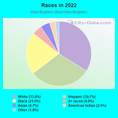
- 7,89833.9%White
- 7,14530.7%Hispanic or Latino
- 4,89821.0%Black
- 1,1454.9%Two or more races
- 1,0984.7%Asian
- 6842.9%American Indian
- 4241.8%Some other race

Distribution of median household income
![Distribution of median household income]()
- 859Less than $10,000
- 799$10,000 to $19,999
- 1,546$20,000 to $29,999
- 945$30,000 to $39,999
- 691$40,000 to $49,999
- 446$50,000 to $59,999
- 687$60,000 to $74,999
- 714$75,000 to $99,999
- 913$100,000 to $124,999
- 850$125,000 to $149,999
- 1,182$150,000 to $199,999
- 1,146$200,000 or more

Distribution of owner-occupied house/condo value
![Distribution of owner-occupied house/condo value]()
- 717Less than $50,000
- 608$50,000 to $99,999
- 39$100,000 to $149,999
- 390$150,000 to $199,999
- 248$200,000 to $249,999
- 284$250,000 to $299,999
- 435$300,000 to $399,999
- 761$400,000 to $499,999
- 1,793$500,000 to $749,999
- 1,388$750,000 to $999,999
- 541$1,000,000 or more

Distribution of rent paid by renters
![Distribution of rent paid by renters]()
- 2,069$100 to $199
- 5,725$200 to $299
- 1,092$300 to $399
- 1,839$500 to $599
- 1,314$600 to $699
- 156$700 to $799
- 141$800 to $899
- 650$900 to $999
- 779$1,000 to $1,249
- 496$1,250 to $1,499
- 1,334$1,500 to $1,999
- 1,168$2,000 or more

| Males: | 9,844 |
| Females: | 11,105 |
| Males: | 40.3 years |
| Females: | 40.8 years |
Average household size:
| West Brighton (West New Brighton): | 7.6 people |
| New York: | 2.5 people |
Percentage of family households:
| West Brighton (West New Brighton): | 51.4% |
| New York: | 41.3% |
| Here: | 45.4% |
| New York: | 42.3% |
Percentage of married-couple families with children (among all households):
| West Brighton (West New Brighton): | 18.9% |
| New York: | 57.0% |
Percentage of single-mother households (among all households):
| West Brighton (West New Brighton): | 20.2% |
| New York: | 9.3% |
Percentage of never married males 15 years old and over:
Percentage of never married females 15 years old and over:
| West Brighton (West New Brighton): | 18.8% |
| New York: | 19.8% |
Percentage of never married females 15 years old and over:
| West Brighton (West New Brighton): | 23.0% |
| New York: | 18.9% |
Percentage of people that speak English not well or not at all:
| West Brighton (West New Brighton): | 6.7% |
| New York: | 6.8% |
Percentage of people born in this state:
Percentage of people born in another U.S. state:
Percentage of native residents but born outside the U.S.:
Percentage of foreign born residents:
| Here: | 67.0% |
| New York: | 62.5% |
Percentage of people born in another U.S. state:
| West Brighton (West New Brighton): | 4.6% |
| New York: | 12.2% |
Percentage of native residents but born outside the U.S.:
| Here: | 5.0% |
| New York: | 2.6% |
Percentage of foreign born residents:
| Here: | 24.6% |
| New York: | 22.7% |
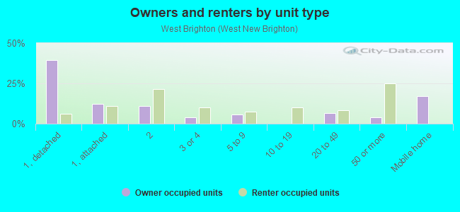
Owner-occupied
Renter-occupied

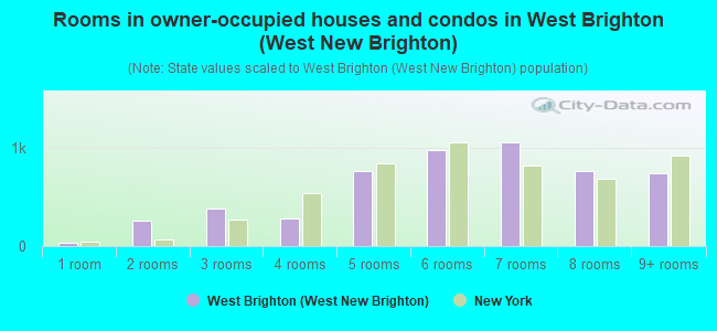
- Rooms in owner-occupied houses and condos in West Brighton <
> - 381 room
- 2632 rooms
- 3853 rooms
- 2804 rooms
- 7625 rooms
- 9766 rooms
- 1,0607 rooms
- 7698 rooms
- 7499+ rooms
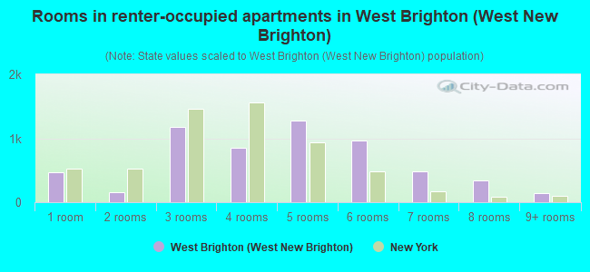
- Rooms in renter-occupied apartments in West Brighton <
> - 4741 room
- 1572 rooms
- 1,1823 rooms
- 8564 rooms
- 1,2725 rooms
- 9626 rooms
- 4787 rooms
- 3438 rooms
- 1389+ rooms
Owner-occupied
Renter-occupied
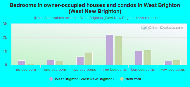
- Bedrooms in owner-occupied houses and condos in West Brighton <
> - 321no bedroom
- 3411 bedroom
- 5892 bedrooms
- 2,2173 bedrooms
- 1,0134 bedrooms
- 3085+ bedrooms
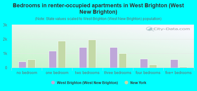
- Bedrooms in renter-occupied apartments in West Brighton <
> - 424no bedroom
- 1,1681 bedroom
- 1,4302 bedrooms
- 1,4293 bedrooms
- 6204 bedrooms
- 5655+ bedrooms
Average number of cars or other vehicles available in houses/condos:
Average number of cars or other vehicles available in apartments:
| This neighborhood: | 1.8 |
| New York: | 1.7 |
Average number of cars or other vehicles available in apartments:
| Here: | |
| New York: |
Percentage of units with a mortgage:
| West Brighton (West New Brighton): | 64.5% |
| New York: | 58.3% |
Average estimated value of detached houses in 2022 (39.9% of all units):
| West Brighton (West New Brighton): | $651,944 |
| New York: | $476,719 |
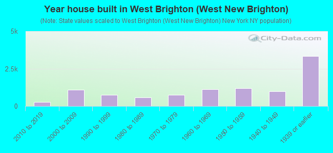
- Year house built in West Brighton <
> - 02020 or later
- 2842010 to 2019
- 1,0912000 to 2009
- 7521990 to 1999
- 5861980 to 1989
- 7541970 to 1979
- 1,1421960 to 1969
- 1,1961950 to 1959
- 9911940 to 1949
- 3,3441939 or earlier
Travel time to work (commute)
![Travel time to work (commute)]()
- 164Less than 5 minutes
- 5455 to 9 minutes
- 1,05810 to 14 minutes
- 1,23915 to 19 minutes
- 93220 to 24 minutes
- 26725 to 29 minutes
- 87830 to 34 minutes
- 30435 to 39 minutes
- 40640 to 44 minutes
- 83645 to 59 minutes
- 1,23660 to 89 minutes
- 1,16390 or more minutes

Means of transportation to work
![Means of transportation to work]()
- 51.8%4,982Drove a car alone
- 9.8%945Carpooled
- 17.7%1,705Bus
- 5.0%477Subway or elevated rail
- 1.6%156Long-distance train or commuter rail
- 6.9%662Ferryboat
- 4.1%395Taxi
- 2.7%257Bicycle
- 7.3%706Walked
- 5.2%497Other means
- 8.3%800Worked at home

Time leaving home to go to work
![Time leaving home to go to work]()
- 32212:00 a.m. to 4:59 a.m.
- 4485:00 a.m. to 5:29 a.m.
- 3385:30 a.m. to 5:59 a.m.
- 1,0816:00 a.m. to 6:29 a.m.
- 7006:30 a.m. to 6:59 a.m.
- 1,7347:00 a.m. to 7:29 a.m.
- 7067:30 a.m. to 7:59 a.m.
- 6508:00 a.m. to 8:29 a.m.
- 3878:30 a.m. to 8:59 a.m.
- 6409:00 a.m. to 9:59 a.m.
- 14310:00 a.m. to 10:59 a.m.
- 12711:00 a.m. to 11:59 a.m.
- 85912:00 p.m. to 3:59 p.m.
- 8464:00 p.m. to 11:59 p.m.

Occupations of males:
- Percentage of males in management occupations (except farmers):
Here: 8.8% New York: 11.9%
- Percentage of males in business and financial operations occupations:
Here: 3.1% New York: 5.8%
- Percentage of males in computer and mathematical occupations:
Here: 1.9% New York: 4.6%
- Percentage of males in architecture and engineering occupations:
Here: 1.3% New York: 2.6%
- Percentage of males in community and social services occupations:
Here: 1.6% New York: 1.3%
- Percentage of males in education, training, and library occupations:
Here: 4.7% New York: 4.2%
- Percentage of males in arts, design, entertainment, sports, and media occupations:
Here: 1.7% New York: 3.2%
- Percentage of males in healthcare practitioners and technical occupations:
Here: 8.4% New York: 3.6%
- Percentage of males in service occupations:
Here: 18.4% New York: 16.9%
- Percentage of males in sales and office occupations:
Here: 13.4% New York: 15.2%
- Percentage of males in construction, extraction, and maintenance occupations:
Here: 14.0% New York: 8.2%
- Percentage of males in production occupations:
Here: 3.7% New York: 4.6%
- Percentage of males in transportation occupations:
Here: 8.3% New York: 6.7%
- Percentage of males in material moving occupations:
Here: 5.5% New York: 3.7%
Occupations of females:
- Percentage of females in management occupations (except farmers):
Here: 8.4% New York: 9.8%
- Percentage of females in business and financial operations occupations:
Here: 3.7% New York: 6.5%
- Percentage of females in community and social services occupations:
Here: 3.8% New York: 3.1%
- Percentage of females in legal occupations:
Here: 2.3% New York: 1.9%
- Percentage of females in education, training, and library occupations:
Here: 11.4% New York: 11.3%
- Percentage of females in healthcare practitioners and technical occupations:
Here: 14.8% New York: 9.7%
- Percentage of females in service occupations:
Here: 20.6% New York: 21.4%
- Percentage of females in sales and office occupations:
Here: 30.1% New York: 24.9%
- Percentage of females in production occupations:
Here: 1.9% New York: 2.0%
- Percentage of females in material moving occupations:
Here: 1.2% New York: 1.1%
Percentage of people 16-64 in Armed Forces:
| West Brighton (West New Brighton): | 0.1% |
| New York: | 0.2% |
Education in this neighborhood (subdivision or community):
- Percentage of people 3 years and older in K-12 schools:
West Brighton (West New Brighton): 25.9% New York: 15.4%
- Percentage of people 3 years and older in undergraduate colleges:
West Brighton (West New Brighton): 6.3% New York: 5.3%
- Percentage of people 3 years and older in grad. or professional schools:
West Brighton (West New Brighton): 3.2% New York: 1.8%
- Percentage of students K-12 enrolled in private schools:
West Brighton (West New Brighton): 40.9% New York: 15.5%
Percentage of population below poverty level:
| West Brighton (West New Brighton): | 18.5% |
| New York: | 14.3% |
Percentage of married-couple families with both working:
| West Brighton (West New Brighton): | 86.3% |
| New York: | 72.1% |
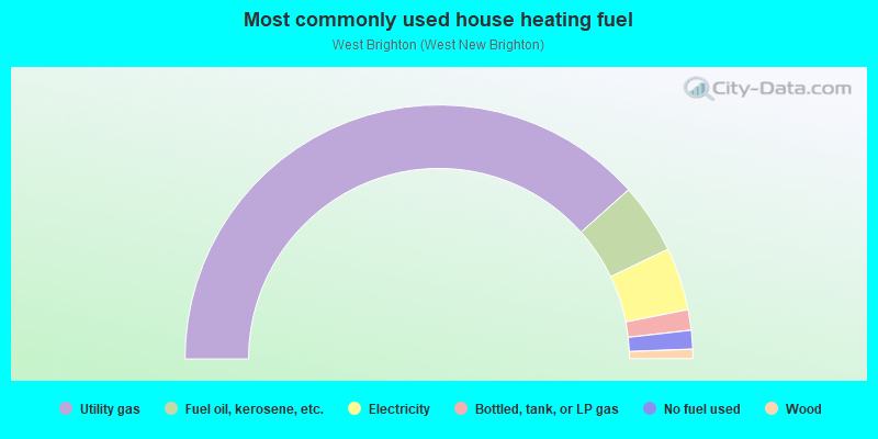
- 76.9%Utility gas
- 9.0%Fuel oil, kerosene, etc.
- 8.0%Electricity
- 2.6%Bottled, tank, or LP gas
- 2.4%No fuel used
- 1.2%Wood
Roads and streets:
Forest Ave
Length: 2.31 miles
Direction: E-W
Address range: 230 to 1210
Direction: E-W
Address range: 230 to 1210
Delafield Ave
Length: 1.81 miles
Directions: E-W, SW-NE
Address range: 1 to 899
Directions: E-W, SW-NE
Address range: 1 to 899
Castleton Ave
Length: 1.51 miles
Direction: E-W
Address range: 717 to 1380
Direction: E-W
Address range: 717 to 1380
Bard Ave
Length: 1.38 miles
Directions: E-W, N-S, SE-NW, SW-NE
Address range: 256 to 935
Directions: E-W, N-S, SE-NW, SW-NE
Address range: 256 to 935
Broadway
Length: 1.16 miles
Directions: N-S, SE-NW
Address range: 74 to 748
Directions: N-S, SE-NW
Address range: 74 to 748
Davis Ave
Length: 1.09 miles
Direction: N-S
Address range: 264 to 859
Direction: N-S
Address range: 264 to 859
Cary Ave
Length: 0.97 miles
Direction: E-W
Address range: 260 to 699
Direction: E-W
Address range: 260 to 699
Oakland Ave
Length: 0.95 miles
Direction: N-S
Address range: 300 to 799
Direction: N-S
Address range: 300 to 799
Pelton Ave
Length: 0.93 miles
Direction: N-S
Address range: 330 to 809
Direction: N-S
Address range: 330 to 809
Clove Rd
Length: 0.91 miles
Directions: E-W, N-S, SE-NW
Address range: 200 to 860
Directions: E-W, N-S, SE-NW
Address range: 200 to 860
Bement Ave
Length: 0.90 miles
Direction: N-S
Address range: 300 to 775
Direction: N-S
Address range: 300 to 775
N Burgher Ave
Length: 0.81 miles
Directions: N-S, SE-NW
Address range: 170 to 729
Directions: N-S, SE-NW
Address range: 170 to 729
Myrtle Ave
Length: 0.75 miles
Direction: E-W
Address range: 1 to 299
Direction: E-W
Address range: 1 to 299
Morrison Ave
Length: 0.72 miles
Direction: E-W
Address range: 1 to 280
Direction: E-W
Address range: 1 to 280
Harvest Ave
Length: 0.69 miles
Direction: E-W
Address range: 1 to 279
Direction: E-W
Address range: 1 to 279
Lawrence Ave
Length: 0.58 miles
Direction: N-S
Address range: 1 to 299
Direction: N-S
Address range: 1 to 299
Taylor St
Length: 0.53 miles
Direction: N-S
Address range: 72 to 399
Direction: N-S
Address range: 72 to 399
Elizabeth St
Length: 0.52 miles
Directions: N-S, SE-NW
Address range: 1 to 299
Directions: N-S, SE-NW
Address range: 1 to 299
Mathews Ave
Length: 0.41 miles
Direction: E-W
Address range: 1 to 199
Direction: E-W
Address range: 1 to 199
Whitewood Ave
Length: 0.39 miles
Direction: E-W
Address range: 8 to 249
Direction: E-W
Address range: 8 to 249
Dubois Ave
Length: 0.39 miles
Direction: N-S
Address range: 1 to 209
Direction: N-S
Address range: 1 to 209
Henderson Ave
Length: 0.39 miles
Direction: E-W
Address range: 680 to 826
Direction: E-W
Address range: 680 to 826
Hart Ave
Length: 0.33 miles
Direction: N-S
Address range: 200 to 375
Direction: N-S
Address range: 200 to 375
Regan Ave
Length: 0.32 miles
Direction: N-S
Address range: 1 to 176
Direction: N-S
Address range: 1 to 176
E Raleigh Ave
Length: 0.32 miles
Direction: E-W
Address range: 1 to 123
Direction: E-W
Address range: 1 to 123
Roe St
Length: 0.30 miles
Direction: N-S
Address range: 1 to 199
Direction: N-S
Address range: 1 to 199
Greenleaf Ave
Length: 0.30 miles
Direction: N-S
Address range: 1 to 149
Direction: N-S
Address range: 1 to 149
Post Ave
Length: 0.30 miles
Direction: E-W
Address range: 318 to 868
Direction: E-W
Address range: 318 to 868
N Mada Ave
Length: 0.30 miles
Direction: N-S
Address range: 1 to 199
Direction: N-S
Address range: 1 to 199
Rector St
Length: 0.28 miles
Direction: N-S
Address range: 83 to 198
Direction: N-S
Address range: 83 to 198
Seneca St
Length: 0.28 miles
Direction: E-W
Address range: 1 to 139
Direction: E-W
Address range: 1 to 139
City Blvd
Length: 0.27 miles
Directions: N-S, SE-NW
Address range: 1 to 133
Directions: N-S, SE-NW
Address range: 1 to 133
Elwood Pl
Length: 0.27 miles
Direction: E-W
Address range: 1 to 105
Direction: E-W
Address range: 1 to 105
Raymond Pl
Length: 0.27 miles
Directions: N-S, SE-NW
Address range: 1 to 148
Directions: N-S, SE-NW
Address range: 1 to 148
Gregg Pl
Length: 0.27 miles
Direction: E-W
Address range: 1 to 105
Direction: E-W
Address range: 1 to 105
Floyd St
Length: 0.26 miles
Direction: E-W
Address range: 1 to 199
Direction: E-W
Address range: 1 to 199
Dongan St
Length: 0.25 miles
Direction: N-S
Address range: 100 to 299
Direction: N-S
Address range: 100 to 299
Alaska St
Length: 0.25 miles
Directions: N-S, SE-NW
Address range: 56 to 186
Directions: N-S, SE-NW
Address range: 56 to 186
Metropolitan Ave
Length: 0.24 miles
Direction: N-S
Address range: 530 to 645
Direction: N-S
Address range: 530 to 645
Hartford Ave
Length: 0.23 miles
Direction: N-S
Address range: 1 to 132
Direction: N-S
Address range: 1 to 132
Barker St
Length: 0.23 miles
Direction: N-S
Address range: 1 to 116
Direction: N-S
Address range: 1 to 116
Dekay St
Length: 0.22 miles
Direction: E-W
Address range: 1 to 99
Direction: E-W
Address range: 1 to 99
Caroline St
Length: 0.22 miles
Direction: N-S
Address range: 1 to 145
Direction: N-S
Address range: 1 to 145
Degroot Pl
Length: 0.21 miles
Direction: E-W
Address range: 1 to 99
Direction: E-W
Address range: 1 to 99
Tyler Ave
Length: 0.20 miles
Directions: E-W, SW-NE
Address range: 1 to 734
Directions: E-W, SW-NE
Address range: 1 to 734
Walbrooke Ave
Length: 0.20 miles
Direction: N-S
Address range: 35 to 132
Direction: N-S
Address range: 35 to 132
Market St
Length: 0.19 miles
Direction: E-W
Address range: 161 to 248
Direction: E-W
Address range: 161 to 248
South St
Length: 0.18 miles
Direction: E-W
Address range: 1 to 145
Direction: E-W
Address range: 1 to 145
Hart Blvd
Length: 0.18 miles
Direction: N-S
Address range: 70 to 168
Direction: N-S
Address range: 70 to 168
W Raleigh Ave
Length: 0.18 miles
Direction: SW-NE
Address range: 1 to 75
Direction: SW-NE
Address range: 1 to 75
Sheffield St
Length: 0.17 miles
Direction: N-S
Address range: 343 to 469
Direction: N-S
Address range: 343 to 469
Burgher Ave N
Length: 0.17 miles
Directions: N-S, SE-NW
Address range: 600 to 630
Directions: N-S, SE-NW
Address range: 600 to 630
S St Austins Pl
Length: 0.16 miles
Direction: E-W
Address range: 1 to 198
Direction: E-W
Address range: 1 to 198
Lyceum Ct
Length: 0.16 miles
Directions: E-W, SE-NW
Address range: 1 to 199
Directions: E-W, SE-NW
Address range: 1 to 199
N St Austins Pl
Length: 0.16 miles
Direction: E-W
Address range: 1 to 198
Direction: E-W
Address range: 1 to 198
Colonial Ct
Length: 0.15 miles
Direction: E-W
Address range: 1 to 58
Direction: E-W
Address range: 1 to 58
Randall Ave
Length: 0.15 miles
Direction: N-S
Address range: 19 to 99
Direction: N-S
Address range: 19 to 99
Crosshill St
Length: 0.14 miles
Direction: E-W
Address range: 56 to 100
Direction: E-W
Address range: 56 to 100
Clove Lake Pl
Length: 0.14 miles
Direction: SW-NE
Address range: 1 to 21
Direction: SW-NE
Address range: 1 to 21
Coughlan Ave
Length: 0.14 miles
Direction: E-W
Address range: 1 to 57
Direction: E-W
Address range: 1 to 57
Parkview Pl
Length: 0.14 miles
Direction: SW-NE
Address range: 1 to 58
Direction: SW-NE
Address range: 1 to 58
Douglas Ave
Length: 0.14 miles
Direction: E-W
Address range: 1 to 57
Direction: E-W
Address range: 1 to 57
West St
Length: 0.14 miles
Direction: N-S
Address range: 1 to 217
Direction: N-S
Address range: 1 to 217
Bosworth St
Length: 0.13 miles
Direction: E-W
Address range: 1 to 45
Direction: E-W
Address range: 1 to 45
Britton St
Length: 0.13 miles
Direction: E-W
Address range: 1 to 69
Direction: E-W
Address range: 1 to 69
Trinity Pl
Length: 0.13 miles
Direction: E-W
Address range: 2 to 49
Direction: E-W
Address range: 2 to 49
Starr Ave
Length: 0.12 miles
Direction: E-W
Address range: 1 to 100
Direction: E-W
Address range: 1 to 100
Cornell Ave
Length: 0.12 miles
Direction: E-W
Address range: 1 to 98
Direction: E-W
Address range: 1 to 98
Purcell St
Length: 0.12 miles
Direction: SW-NE
Address range: 67 to 117
Direction: SW-NE
Address range: 67 to 117
Disosway Pl
Length: 0.11 miles
Direction: E-W
Address range: 1 to 99
Direction: E-W
Address range: 1 to 99
Marion St
Length: 0.11 miles
Direction: E-W
Address range: 135 to 199
Direction: E-W
Address range: 135 to 199
Campbell Ave
Length: 0.11 miles
Direction: N-S
Address range: 140 to 199
Direction: N-S
Address range: 140 to 199
Blaine Ct
Length: 0.11 miles
Direction: E-W
Address range: 1 to 43
Direction: E-W
Address range: 1 to 43
Glenwood Pl
Length: 0.10 miles
Direction: SW-NE
Address range: 1 to 43
Direction: SW-NE
Address range: 1 to 43
White Pl
Length: 0.10 miles
Direction: E-W
Address range: 1 to 99
Direction: E-W
Address range: 1 to 99
Kissel Ave
Length: 0.10 miles
Direction: N-S
Address range: 477 to 529
Direction: N-S
Address range: 477 to 529
St Austins Pl
Length: 0.10 miles
Direction: N-S
Address range: 1 to 51
Direction: N-S
Address range: 1 to 51
Hoyt Ave
Length: 0.10 miles
Direction: N-S
Address range: 440 to 499
Direction: N-S
Address range: 440 to 499
Nutly Pl
Length: 0.10 miles
Direction: E-W
Address range: 1 to 99
Direction: E-W
Address range: 1 to 99
Arcadia Pl
Length: 0.10 miles
Direction: E-W
Address range: 20 to 99
Direction: E-W
Address range: 20 to 99
Bodine St
Length: 0.10 miles
Direction: N-S
Address range: 125 to 199
Direction: N-S
Address range: 125 to 199
Parsons Pl
Length: 0.10 miles
Direction: E-W
Address range: 1 to 99
Direction: E-W
Address range: 1 to 99
Doe Pl
Length: 0.09 miles
Direction: E-W
Address range: 1 to 50
Direction: E-W
Address range: 1 to 50
Howe St
Length: 0.09 miles
Direction: E-W
Address range: 1 to 47
Direction: E-W
Address range: 1 to 47
Driprock St
Length: 0.09 miles
Direction: N-S
Address range: 1 to 99
Direction: N-S
Address range: 1 to 99
Hurst St
Length: 0.09 miles
Direction: E-W
Address range: 1 to 79
Direction: E-W
Address range: 1 to 79
Dana St
Length: 0.08 miles
Direction: E-W
Address range: 1 to 99
Direction: E-W
Address range: 1 to 99
Huron Pl
Length: 0.08 miles
Direction: E-W
Address range: 1 to 98
Direction: E-W
Address range: 1 to 98
Welles Ct
Length: 0.08 miles
Direction: E-W
Address range: 1 to 32
Direction: E-W
Address range: 1 to 32
Taylor Ct
Length: 0.08 miles
Direction: E-W
Address range: 1 to 20
Direction: E-W
Address range: 1 to 20
Manor Rd
Length: 0.08 miles
Direction: N-S
Address range: 1 to 49
Direction: N-S
Address range: 1 to 49
Baker Pl
Length: 0.08 miles
Direction: E-W
Address range: 1 to 66
Direction: E-W
Address range: 1 to 66
Dallas St
Length: 0.08 miles
Direction: E-W
Address range: 1 to 31
Direction: E-W
Address range: 1 to 31
Hardin Ave
Length: 0.08 miles
Direction: SE-NW
Address range: 1 to 99
Direction: SE-NW
Address range: 1 to 99
Guinevere Ln
Length: 0.08 miles
Direction: E-W
Address range: 1 to 99
Direction: E-W
Address range: 1 to 99
Ford Pl
Length: 0.07 miles
Direction: SE-NW
Address range: 1 to 99
Direction: SE-NW
Address range: 1 to 99
Freeman Pl
Length: 0.07 miles
Direction: SE-NW
Address range: 1 to 99
Direction: SE-NW
Address range: 1 to 99
Brighton Ave
Length: 0.07 miles
Direction: N-S
Address range: 780 to 819
Direction: N-S
Address range: 780 to 819
Chappell St
Length: 0.06 miles
Direction: N-S
Address range: 1 to 34
Direction: N-S
Address range: 1 to 34
Jones Pl
Length: 0.06 miles
Direction: E-W
Address range: 1 to 99
Direction: E-W
Address range: 1 to 99
Berwick Pl
Length: 0.06 miles
Direction: E-W
Address range: 24 to 32
Direction: E-W
Address range: 24 to 32
Wayne St
Length: 0.06 miles
Direction: E-W
Address range: 127 to 150
Direction: E-W
Address range: 127 to 150
Clarion Ct
Length: 0.06 miles
Direction: E-W
Address range: 1 to 36
Direction: E-W
Address range: 1 to 36
Brooks Pl
Length: 0.06 miles
Direction: N-S
Address range: 2 to 99
Direction: N-S
Address range: 2 to 99
Chrissy Ct
Length: 0.06 miles
Directions: E-W, SW-NE
Address range: 1 to 40
Directions: E-W, SW-NE
Address range: 1 to 40
Green St
Length: 0.06 miles
Direction: E-W
Address range: 1 to 98
Direction: E-W
Address range: 1 to 98
Lynnhaven Pl
Length: 0.05 miles
Direction: SE-NW
Address range: 1 to 99
Direction: SE-NW
Address range: 1 to 99
Alban St
Length: 0.05 miles
Direction: E-W
Address range: 1 to 30
Direction: E-W
Address range: 1 to 30
Berwin Ln
Length: 0.05 miles
Direction: SE-NW
Address range: 1 to 99
Direction: SE-NW
Address range: 1 to 99
State St
Length: 0.05 miles
Direction: N-S
Address range: 66 to 99
Direction: N-S
Address range: 66 to 99
Woodruff Ln
Length: 0.05 miles
Direction: E-W
Address range: 119 to 143
Direction: E-W
Address range: 119 to 143
Norma Pl
Length: 0.05 miles
Direction: E-W
Address range: 1 to 199
Direction: E-W
Address range: 1 to 199
Olivia Ct
Length: 0.05 miles
Directions: E-W, N-S
Directions: E-W, N-S
Olive St (Olivia Ct)
Length: 0.05 miles
Direction: SW-NE
Address range: 10 to 53
Direction: SW-NE
Address range: 10 to 53
Lloyd Ct
Length: 0.04 miles
Direction: N-S
Address range: 1 to 22
Direction: N-S
Address range: 1 to 22
Noble Pl
Length: 0.04 miles
Direction: E-W
Address range: 1 to 100
Direction: E-W
Address range: 1 to 100
Law Pl
Length: 0.04 miles
Direction: SE-NW
Address range: 1 to 15
Direction: SE-NW
Address range: 1 to 15
Rayfield Ct
Length: 0.04 miles
Direction: SE-NW
Address range: 1 to 35
Direction: SE-NW
Address range: 1 to 35
Rocco Ct
Length: 0.03 miles
Directions: E-W, N-S
Directions: E-W, N-S
Tom Ct
Length: 0.03 miles
Direction: E-W
Direction: E-W
Islin Pl
Length: 0.03 miles
Direction: N-S
Address range: 1 to 17
Direction: N-S
Address range: 1 to 17
Van St
Length: 0.01 miles
Direction: SE-NW
Address range: 52 to 68
Direction: SE-NW
Address range: 52 to 68