West Baltimore neighborhood in Baltimore, Maryland (MD), 21223, 21216, 21217 detailed profile
Settings
X


Business Search - 14 Million verified businesses
Area: 2.703 square miles
Population: 38,495
Population density:
| West Baltimore: | 14,243 people per square mile |
| Baltimore: | 7,053 people per square mile |

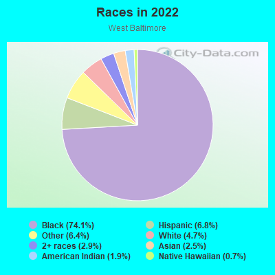
- 35,70974.1%Black
- 3,2526.8%Hispanic or Latino
- 3,1016.4%Some other race
- 2,2574.7%White
- 1,4042.9%Two or more races
- 1,1952.5%Asian
- 9201.9%American Indian
- 3320.7%Native Hawaiian and Other
Pacific Islander
Distribution of median household income
![Distribution of median household income]()
- 2,304Less than $10,000
- 4,913$10,000 to $19,999
- 3,987$20,000 to $29,999
- 2,964$30,000 to $39,999
- 2,719$40,000 to $49,999
- 1,655$50,000 to $59,999
- 1,914$60,000 to $74,999
- 2,056$75,000 to $99,999
- 1,377$100,000 to $124,999
- 1,468$125,000 to $149,999
- 959$150,000 to $199,999
- 853$200,000 or more

Distribution of owner-occupied house/condo value
![Distribution of owner-occupied house/condo value]()
- 8,260Less than $50,000
- 7,994$50,000 to $99,999
- 2,222$100,000 to $149,999
- 2,600$150,000 to $199,999
- 1,261$200,000 to $249,999
- 938$250,000 to $299,999
- 1,039$300,000 to $399,999
- 957$400,000 to $499,999
- 1,018$500,000 to $749,999
- 535$750,000 to $999,999
- 2,635$1,000,000 or more

Distribution of rent paid by renters
![Distribution of rent paid by renters]()
- 1,180Less than $100
- 3,233$100 to $199
- 5,434$200 to $299
- 4,284$300 to $399
- 1,346$400 to $499
- 2,656$500 to $599
- 3,770$600 to $699
- 2,601$700 to $799
- 2,086$800 to $899
- 1,817$900 to $999
- 2,307$1,000 to $1,249
- 2,634$1,250 to $1,499
- 1,121$1,500 to $1,999
- 2,185$2,000 or more

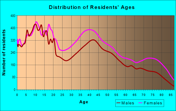
| Males: | 18,135 |
| Females: | 20,360 |
Males:
| This neighborhood: | |
| Whole city: |
| This neighborhood: | 44.4 years |
| Whole city: | 38.2 years |
Average household size:
| West Baltimore: | 3.2 people |
| Baltimore: | 2.2 people |
Percentage of family households:
| West Baltimore: | 30.1% |
| Baltimore: | 34.2% |
| Here: | 13.3% |
| Baltimore: | 23.3% |
Percentage of married-couple families with children (among all households):
| West Baltimore: | 22.5% |
| Baltimore: | 22.4% |
Percentage of single-mother households (among all households):
| West Baltimore: | 33.6% |
| Baltimore: | 18.7% |
Percentage of never married males 15 years old and over:
Percentage of never married females 15 years old and over:
| West Baltimore: | 28.9% |
| Baltimore: | 25.1% |
Percentage of never married females 15 years old and over:
| West Baltimore: | 30.3% |
| city: | 27.5% |
Percentage of people that speak English not well or not at all:
| West Baltimore: | 1.0% |
| Baltimore: | 2.3% |
Percentage of people born in this state:
Percentage of people born in another U.S. state:
Percentage of native residents but born outside the U.S.:
Percentage of foreign born residents:
| Here: | 81.4% |
| Baltimore: | 64.4% |
Percentage of people born in another U.S. state:
| West Baltimore: | 13.6% |
| Baltimore: | 25.0% |
Percentage of native residents but born outside the U.S.:
| Here: | 1.2% |
| city: | 0.9% |
Percentage of foreign born residents:
| Here: | 5.2% |
| Baltimore: | 9.7% |
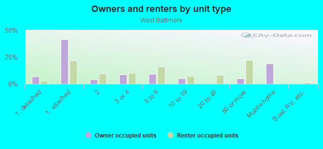
Owner-occupied
Renter-occupied

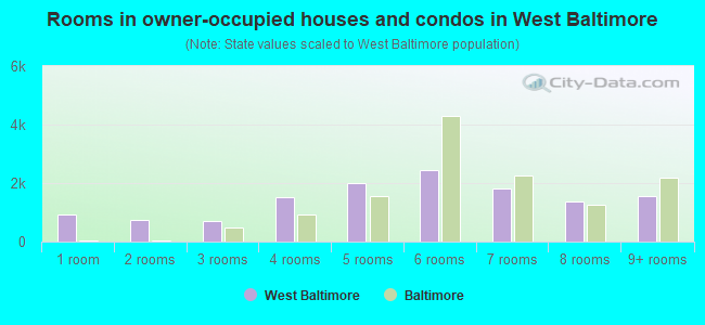
- Rooms in owner-occupied houses and condos in West Baltimore
- 9241 room
- 7312 rooms
- 7183 rooms
- 1,5114 rooms
- 1,9965 rooms
- 2,4456 rooms
- 1,8127 rooms
- 1,3868 rooms
- 1,5399+ rooms
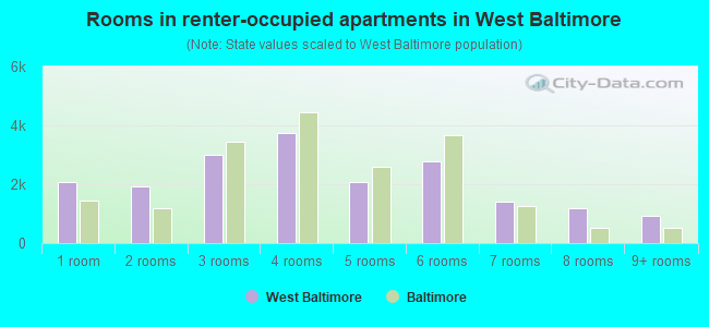
- Rooms in renter-occupied apartments in West Baltimore
- 2,0881 room
- 1,9132 rooms
- 3,0083 rooms
- 3,7384 rooms
- 2,0825 rooms
- 2,7626 rooms
- 1,3907 rooms
- 1,1678 rooms
- 9129+ rooms
Owner-occupied
Renter-occupied
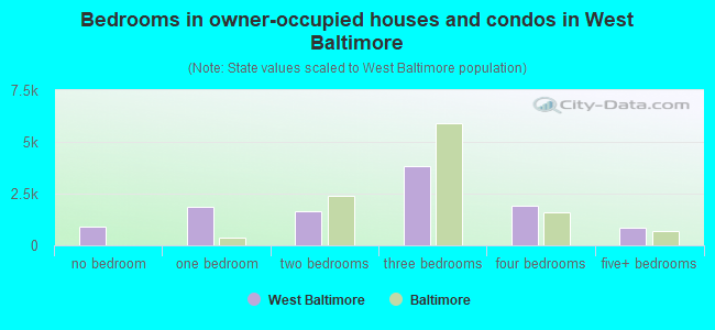
- Bedrooms in owner-occupied houses and condos in West Baltimore
- 924no bedroom
- 1,8401 bedroom
- 1,6232 bedrooms
- 3,8533 bedrooms
- 1,9244 bedrooms
- 8375+ bedrooms
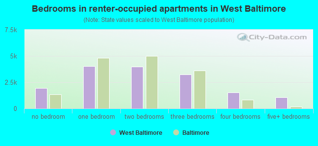
- Bedrooms in renter-occupied apartments in West Baltimore
- 1,932no bedroom
- 4,0111 bedroom
- 3,9882 bedrooms
- 3,2483 bedrooms
- 1,5074 bedrooms
- 1,0835+ bedrooms
Average number of cars or other vehicles available in houses/condos:
Average number of cars or other vehicles available in apartments:
| This neighborhood: | 1.5 |
| Baltimore: | 1.5 |
Average number of cars or other vehicles available in apartments:
| Here: | |
| city: |
Percentage of units with a mortgage:
| West Baltimore: | 47.7% |
| Baltimore: | 64.3% |
Average estimated value of townhouses or other attached units in 2022 (69.3% of all units):
| This neighborhood: | $136,703 |
| city: | $206,258 |
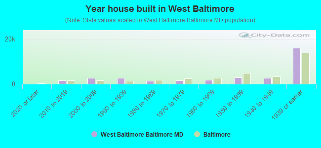
- Year house built in West Baltimore
- 02020 or later
- 1,5252010 to 2019
- 2,6722000 to 2009
- 2,6431990 to 1999
- 1,4001980 to 1989
- 1,5721970 to 1979
- 1,6731960 to 1969
- 2,8641950 to 1959
- 2,5641940 to 1949
- 16,0371939 or earlier
Travel time to work (commute)
![Travel time to work (commute)]()
- 326Less than 5 minutes
- 6595 to 9 minutes
- 68110 to 14 minutes
- 1,35315 to 19 minutes
- 1,82320 to 24 minutes
- 71825 to 29 minutes
- 2,47530 to 34 minutes
- 47435 to 39 minutes
- 54240 to 44 minutes
- 1,88845 to 59 minutes
- 1,02260 to 89 minutes
- 90790 or more minutes

Means of transportation to work
![Means of transportation to work]()
- 51.6%6,696Drove a car alone
- 11.2%1,460Carpooled
- 29.0%3,770Bus
- 10.9%1,410Subway or elevated rail
- 2.9%374Long-distance train or commuter rail
- 12.8%1,668Light rail, streetcar or trolley
- 8.1%1,055Taxi
- 4.3%562Motorcycle
- 2.8%365Bicycle
- 9.9%1,285Walked
- 6.9%894Other means
- 21.7%2,814Worked at home

Time leaving home to go to work
![Time leaving home to go to work]()
- 80912:00 a.m. to 4:59 a.m.
- 5565:00 a.m. to 5:29 a.m.
- 5605:30 a.m. to 5:59 a.m.
- 1,2576:00 a.m. to 6:29 a.m.
- 1,0836:30 a.m. to 6:59 a.m.
- 1,3177:00 a.m. to 7:29 a.m.
- 1,0037:30 a.m. to 7:59 a.m.
- 1,3328:00 a.m. to 8:29 a.m.
- 7828:30 a.m. to 8:59 a.m.
- 6679:00 a.m. to 9:59 a.m.
- 45610:00 a.m. to 10:59 a.m.
- 49811:00 a.m. to 11:59 a.m.
- 1,30012:00 p.m. to 3:59 p.m.
- 7084:00 p.m. to 11:59 p.m.

Occupations of males:
- Percentage of males in management occupations (except farmers):
Here: 6.9% city: 10.7%
- Percentage of males in business and financial operations occupations:
Here: 2.2% city: 5.9%
- Percentage of males in computer and mathematical occupations:
Here: 1.9% city: 6.1%
- Percentage of males in architecture and engineering occupations:
Here: 1.0% city: 2.9%
- Percentage of males in life, physical, and social science occupations:
Here: 2.6% city: 2.3%
- Percentage of males in community and social services occupations:
Here: 2.7% city: 1.6%
- Percentage of males in education, training, and library occupations:
Here: 2.7% city: 5.4%
- Percentage of males in healthcare practitioners and technical occupations:
Here: 1.1% city: 4.0%
- Percentage of males in service occupations:
Here: 22.0% city: 14.7%
- Percentage of males in sales and office occupations:
Here: 15.4% city: 14.2%
- Percentage of males in construction, extraction, and maintenance occupations:
Here: 7.8% city: 5.6%
- Percentage of males in production occupations:
Here: 3.3% city: 4.2%
- Percentage of males in transportation occupations:
Here: 10.5% city: 6.8%
- Percentage of males in material moving occupations:
Here: 15.4% city: 7.0%
Occupations of females:
- Percentage of females in management occupations (except farmers):
Here: 8.2% city: 10.1%
- Percentage of females in business and financial operations occupations:
Here: 7.5% city: 6.6%
- Percentage of females in community and social services occupations:
Here: 2.8% city: 3.6%
- Percentage of females in education, training, and library occupations:
Here: 10.2% city: 10.7%
- Percentage of females in healthcare practitioners and technical occupations:
Here: 5.3% city: 9.8%
- Percentage of females in service occupations:
Here: 31.7% city: 20.4%
- Percentage of females in sales and office occupations:
Here: 22.3% city: 22.3%
- Percentage of females in construction, extraction, and maintenance occupations:
Here: 1.4% city: 0.4%
- Percentage of females in production occupations:
Here: 1.6% city: 2.3%
- Percentage of females in transportation occupations:
Here: 2.2% city: 1.7%
- Percentage of females in material moving occupations:
Here: 3.9% city: 1.9%
Percentage of people 16-64 in Armed Forces:
| West Baltimore: | 0.0% |
| Baltimore: | 0.4% |
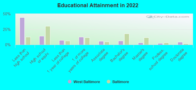
Education in this neighborhood (subdivision or community):
- Percentage of people 3 years and older in K-12 schools:
West Baltimore: 36.7% Baltimore: 14.7%
- Percentage of people 3 years and older in undergraduate colleges:
West Baltimore: 15.7% Baltimore: 6.0%
- Percentage of people 3 years and older in grad. or professional schools:
West Baltimore: 6.3% Baltimore: 2.8%
- Percentage of students K-12 enrolled in private schools:
West Baltimore: 51.4% Baltimore: 12.7%
Percentage of population below poverty level:
| West Baltimore: | 33.1% |
| Baltimore: | 18.5% |
Percentage of married-couple families with both working:
| West Baltimore: | 157.1% |
| Baltimore: | 79.2% |
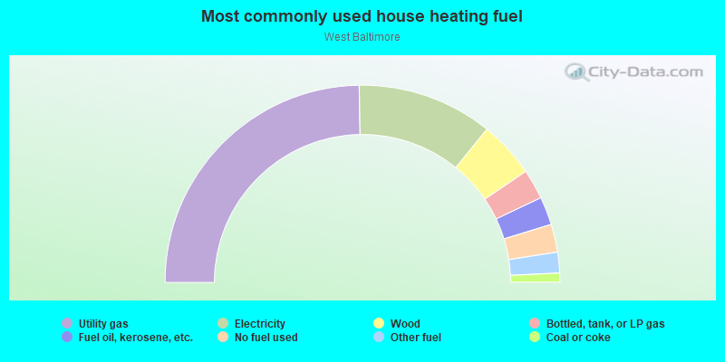
- 49.5%Utility gas
- 22.2%Electricity
- 9.3%Wood
- 4.9%Bottled, tank, or LP gas
- 4.6%Fuel oil, kerosene, etc.
- 4.6%No fuel used
- 3.4%Other fuel
- 1.5%Coal or coke
Highways in this neighborhood:
US Hwy 1 (N Fulton Ave)
Length: 3.03 miles
Directions: N-S, SE-NW, SW-NE
Address range: 1 to 2118
Directions: N-S, SE-NW, SW-NE
Address range: 1 to 2118
US Hwy 40 (W Mulberry St)
Length: 1.59 miles
Direction: E-W
Address range: 900 to 2499
Direction: E-W
Address range: 900 to 2499
US Hwy 40 (W Franklin St)
Length: 1.57 miles
Direction: E-W
Address range: 900 to 2399
Direction: E-W
Address range: 900 to 2399
US Hwy Route 40
Length: 1.21 miles
Direction: E-W
Direction: E-W
State Hwy 129 (Druid Hill Ave)
Length: 0.47 miles
Directions: N-S, SE-NW
Address range: 2300 to 2599
Directions: N-S, SE-NW
Address range: 2300 to 2599
State Hwy 26 (Liberty Heights Ave)
Length: 0.23 miles
Direction: E-W
Direction: E-W
US Hwy 1 (S Fulton Ave)
Length: 0.07 miles
Direction: N-S
Address range: 1 to 31
Direction: N-S
Address range: 1 to 31
Roads and streets:
N Monroe St
Length: 2.08 miles
Directions: N-S, SE-NW
Address range: 13 to 2699
Directions: N-S, SE-NW
Address range: 13 to 2699
W Lafayette Ave
Length: 2.02 miles
Direction: E-W
Address range: 1100 to 2899
Direction: E-W
Address range: 1100 to 2899
W Fayette St
Length: 1.86 miles
Direction: E-W
Address range: 732 to 2427
Direction: E-W
Address range: 732 to 2427
W Lexington St
Length: 1.82 miles
Direction: E-W
Address range: 700 to 2399
Direction: E-W
Address range: 700 to 2399
W Lanvale St
Length: 1.79 miles
Direction: E-W
Address range: 1100 to 2899
Direction: E-W
Address range: 1100 to 2899
W Saratoga St
Length: 1.74 miles
Direction: E-W
Address range: 711 to 2299
Direction: E-W
Address range: 711 to 2299
W North Ave
Length: 1.67 miles
Direction: E-W
Address range: 1207 to 2736
Direction: E-W
Address range: 1207 to 2736
Harlem Ave
Length: 1.67 miles
Direction: E-W
Address range: 900 to 2899
Direction: E-W
Address range: 900 to 2899
Mosher St
Length: 1.64 miles
Direction: E-W
Address range: 1100 to 2799
Direction: E-W
Address range: 1100 to 2799
N Carey St
Length: 1.63 miles
Directions: N-S, SE-NW
Address range: 1 to 1899
Directions: N-S, SE-NW
Address range: 1 to 1899
N Calhoun St
Length: 1.53 miles
Directions: N-S, SE-NW
Address range: 1 to 1799
Directions: N-S, SE-NW
Address range: 1 to 1799
Riggs Ave
Length: 1.52 miles
Direction: E-W
Address range: 1106 to 2799
Direction: E-W
Address range: 1106 to 2799
N Pulaski St
Length: 1.50 miles
Directions: N-S, SE-NW
Address range: 15 to 2499
Directions: N-S, SE-NW
Address range: 15 to 2499
Gwynns Falls Pkwy
Length: 1.50 miles
Directions: E-W, SE-NW, SW-NE
Address range: 1801 to 2799
Directions: E-W, SE-NW, SW-NE
Address range: 1801 to 2799
N Mount St
Length: 1.49 miles
Direction: N-S
Address range: 1 to 1899
Direction: N-S
Address range: 1 to 1899
Edmondson Ave
Length: 1.43 miles
Direction: E-W
Address range: 900 to 2299
Direction: E-W
Address range: 900 to 2299
N Payson St
Length: 1.42 miles
Direction: N-S
Address range: 29 to 2299
Direction: N-S
Address range: 29 to 2299
Vine St
Length: 1.41 miles
Directions: E-W, N-S, SW-NE
Address range: 700 to 2399
Directions: E-W, N-S, SW-NE
Address range: 700 to 2399
Windsor Ave
Length: 1.41 miles
Directions: E-W, N-S, SE-NW, SW-NE
Address range: 1700 to 2899
Directions: E-W, N-S, SE-NW, SW-NE
Address range: 1700 to 2899
N Bentalou St
Length: 1.40 miles
Direction: N-S
Address range: 100 to 2199
Direction: N-S
Address range: 100 to 2199
N Gilmor St
Length: 1.36 miles
Direction: N-S
Address range: 1 to 1699
Direction: N-S
Address range: 1 to 1699
Fallo Dr
Length: 1.31 miles
Directions: E-W, N-S, SE-NW, SW-NE
Directions: E-W, N-S, SE-NW, SW-NE
Baker St
Length: 1.30 miles
Directions: E-W, SW-NE
Address range: 611 to 2599
Directions: E-W, SW-NE
Address range: 611 to 2599
W Fairmount Ave
Length: 1.27 miles
Direction: E-W
Address range: 700 to 2199
Direction: E-W
Address range: 700 to 2199
W Baltimore St
Length: 1.23 miles
Direction: E-W
Address range: 750 to 1821
Direction: E-W
Address range: 750 to 1821
Winchester St
Length: 1.21 miles
Direction: E-W
Address range: 1104 to 2701
Direction: E-W
Address range: 1104 to 2701
Presbury St
Length: 1.17 miles
Direction: E-W
Address range: 1600 to 2799
Direction: E-W
Address range: 1600 to 2799
Westwood Ave
Length: 1.16 miles
Directions: E-W, SW-NE
Address range: 1600 to 2799
Directions: E-W, SW-NE
Address range: 1600 to 2799
N Warwick Ave
Length: 1.12 miles
Directions: N-S, SW-NE
Address range: 723 to 2399
Directions: N-S, SW-NE
Address range: 723 to 2399
Presstman St
Length: 1.07 miles
Direction: E-W
Address range: 1210 to 2299
Direction: E-W
Address range: 1210 to 2299
N Stricker St
Length: 1.03 miles
Direction: N-S
Address range: 1 to 1599
Direction: N-S
Address range: 1 to 1599
N Smallwood St
Length: 0.93 miles
Directions: N-S, SE-NW
Address range: 2 to 2199
Directions: N-S, SE-NW
Address range: 2 to 2199
N Carrollton Ave
Length: 0.89 miles
Direction: N-S
Address range: 1 to 1199
Direction: N-S
Address range: 1 to 1199
Braddish Ave
Length: 0.87 miles
Directions: E-W, N-S, SE-NW
Address range: 700 to 2399
Directions: E-W, N-S, SE-NW
Address range: 700 to 2399
N Woodyear St
Length: 0.86 miles
Directions: N-S, SE-NW
Address range: 1 to 1830
Directions: N-S, SE-NW
Address range: 1 to 1830
Clifton Ave
Length: 0.80 miles
Directions: E-W, SW-NE
Address range: 1500 to 2299
Directions: E-W, SW-NE
Address range: 1500 to 2299
Appleton St
Length: 0.78 miles
Direction: N-S
Address range: 600 to 1899
Direction: N-S
Address range: 600 to 1899
Laurens St
Length: 0.78 miles
Direction: E-W
Address range: 1104 to 1899
Direction: E-W
Address range: 1104 to 1899
McKean Ave
Length: 0.77 miles
Direction: N-S
Address range: 800 to 2099
Direction: N-S
Address range: 800 to 2099
Wheeler Ave
Length: 0.75 miles
Direction: N-S
Address range: 1 to 2099
Direction: N-S
Address range: 1 to 2099
N Arlington Ave
Length: 0.71 miles
Direction: N-S
Address range: 200 to 1029
Direction: N-S
Address range: 200 to 1029
Penrose Ave
Length: 0.71 miles
Direction: E-W
Address range: 1501 to 2299
Direction: E-W
Address range: 1501 to 2299
N Bruce St
Length: 0.70 miles
Direction: N-S
Address range: 1 to 1899
Direction: N-S
Address range: 1 to 1899
N Vincent St
Length: 0.65 miles
Direction: N-S
Address range: 1 to 1099
Direction: N-S
Address range: 1 to 1099
Walbrook Ave
Length: 0.63 miles
Direction: E-W
Address range: 1800 to 2399
Direction: E-W
Address range: 1800 to 2399
N Stockton St
Length: 0.62 miles
Directions: N-S, SE-NW
Address range: 1 to 2499
Directions: N-S, SE-NW
Address range: 1 to 2499
Ashburton St
Length: 0.61 miles
Direction: N-S
Address range: 700 to 2399
Direction: N-S
Address range: 700 to 2399
N Carlton St
Length: 0.59 miles
Directions: N-S, SE-NW
Address range: 1 to 1399
Directions: N-S, SE-NW
Address range: 1 to 1399
N Fremont Ave
Length: 0.57 miles
Directions: N-S, SE-NW
Address range: 1 to 699
Directions: N-S, SE-NW
Address range: 1 to 699
Sarah Ann St
Length: 0.57 miles
Direction: E-W
Address range: 800 to 1899
Direction: E-W
Address range: 800 to 1899
N Schroeder St
Length: 0.56 miles
Direction: N-S
Address range: 1 to 699
Direction: N-S
Address range: 1 to 699
N Parrish St
Length: 0.51 miles
Direction: N-S
Address range: 200 to 1499
Direction: N-S
Address range: 200 to 1499
Moreland Ave
Length: 0.49 miles
Directions: E-W, N-S, SE-NW
Address range: 1300 to 1899
Directions: E-W, N-S, SE-NW
Address range: 1300 to 1899
Whitmore Ave
Length: 0.45 miles
Direction: N-S
Address range: 736 to 1899
Direction: N-S
Address range: 736 to 1899
N Dukeland St
Length: 0.44 miles
Directions: N-S, SE-NW
Address range: 700 to 2399
Directions: N-S, SE-NW
Address range: 700 to 2399
Reisterstown Rd
Length: 0.43 miles
Direction: SE-NW
Address range: 2200 to 2599
Direction: SE-NW
Address range: 2200 to 2599
Ruxton Ave
Length: 0.42 miles
Direction: N-S
Address range: 1600 to 2099
Direction: N-S
Address range: 1600 to 2099
Herbert St
Length: 0.41 miles
Direction: E-W
Address range: 1900 to 2299
Direction: E-W
Address range: 1900 to 2299
Rayner Ave
Length: 0.40 miles
Direction: E-W
Address range: 1800 to 2799
Direction: E-W
Address range: 1800 to 2799
Lorman St
Length: 0.39 miles
Directions: E-W, N-S, SE-NW, SW-NE
Address range: 1700 to 2699
Directions: E-W, N-S, SE-NW, SW-NE
Address range: 1700 to 2699
Woodbrook Ave
Length: 0.36 miles
Directions: N-S, SE-NW
Address range: 2400 to 2613
Directions: N-S, SE-NW
Address range: 2400 to 2613
Retreat St
Length: 0.33 miles
Directions: N-S, SW-NE
Address range: 1400 to 1999
Directions: N-S, SW-NE
Address range: 1400 to 1999
Smithson St
Length: 0.33 miles
Direction: E-W
Address range: 1100 to 1499
Direction: E-W
Address range: 1100 to 1499
Whatcoat St
Length: 0.32 miles
Direction: N-S
Address range: 900 to 1399
Direction: N-S
Address range: 900 to 1399
Calverton Heights Ave
Length: 0.32 miles
Direction: E-W
Address range: 2300 to 2599
Direction: E-W
Address range: 2300 to 2599
Ridgehill Ave
Length: 0.31 miles
Direction: E-W
Address range: 1900 to 2199
Direction: E-W
Address range: 1900 to 2199
Stoddard Aly
Length: 0.31 miles
Directions: N-S, SE-NW
Address range: 2300 to 2599
Directions: N-S, SE-NW
Address range: 2300 to 2599
Pennsylvania Ave
Length: 0.30 miles
Direction: SE-NW
Address range: 2500 to 2718
Direction: SE-NW
Address range: 2500 to 2718
N Martin Luther King Jr Blvd
Length: 0.30 miles
Direction: N-S
Direction: N-S
Kirby Ln
Length: 0.30 miles
Directions: E-W, N-S
Address range: 426 to 799
Directions: E-W, N-S
Address range: 426 to 799
Francis St
Length: 0.30 miles
Direction: SE-NW
Address range: 2400 to 2599
Direction: SE-NW
Address range: 2400 to 2599
Small St
Length: 0.29 miles
Direction: E-W
Address range: 1100 to 1399
Direction: E-W
Address range: 1100 to 1399
Elgin Ave
Length: 0.28 miles
Directions: E-W, SW-NE
Address range: 2000 to 2827
Directions: E-W, SW-NE
Address range: 2000 to 2827
N Brice St
Length: 0.28 miles
Direction: N-S
Address range: 500 to 899
Direction: N-S
Address range: 500 to 899
Tioga Pkwy
Length: 0.26 miles
Directions: E-W, SW-NE
Address range: 3100 to 3388
Directions: E-W, SW-NE
Address range: 3100 to 3388
Frederick Ave
Length: 0.26 miles
Directions: E-W, SW-NE
Address range: 1605 to 1815
Directions: E-W, SW-NE
Address range: 1605 to 1815
N Amity St
Length: 0.26 miles
Direction: N-S
Address range: 1 to 299
Direction: N-S
Address range: 1 to 299
Thomas Ave
Length: 0.24 miles
Direction: N-S
Address range: 1600 to 1899
Direction: N-S
Address range: 1600 to 1899
Bennett Pl
Length: 0.23 miles
Direction: E-W
Address range: 900 to 1099
Direction: E-W
Address range: 900 to 1099
N Poppleton St
Length: 0.22 miles
Direction: N-S
Address range: 1 to 399
Direction: N-S
Address range: 1 to 399
Born Ct
Length: 0.20 miles
Direction: E-W
Address range: 900 to 1199
Direction: E-W
Address range: 900 to 1199
Booth St
Length: 0.20 miles
Direction: E-W
Address range: 1300 to 1499
Direction: E-W
Address range: 1300 to 1499
Prospect Ave
Length: 0.19 miles
Direction: E-W
Address range: 2600 to 2813
Direction: E-W
Address range: 2600 to 2813
Lauretta Ave
Length: 0.19 miles
Direction: E-W
Address range: 1800 to 1999
Direction: E-W
Address range: 1800 to 1999
Mountmor Ct
Length: 0.19 miles
Directions: E-W, N-S, SE-NW
Address range: 1400 to 1683
Directions: E-W, N-S, SE-NW
Address range: 1400 to 1683
Whittier Ave
Length: 0.18 miles
Directions: E-W, SW-NE
Address range: 2000 to 2199
Directions: E-W, SW-NE
Address range: 2000 to 2199
School St
Length: 0.18 miles
Direction: E-W
Address range: 1400 to 1599
Direction: E-W
Address range: 1400 to 1599
N Sheeps Ln
Length: 0.18 miles
Directions: N-S, SE-NW
Address range: 2600 to 2699
Directions: N-S, SE-NW
Address range: 2600 to 2699
Whitelock St
Length: 0.18 miles
Direction: SW-NE
Address range: 1216 to 1599
Direction: SW-NE
Address range: 1216 to 1599
Cloney St
Length: 0.16 miles
Directions: E-W, SE-NW
Address range: 800 to 1199
Directions: E-W, SE-NW
Address range: 800 to 1199
Evergreen St
Length: 0.15 miles
Direction: N-S
Address range: 2200 to 2399
Direction: N-S
Address range: 2200 to 2399
Koko Ln
Length: 0.15 miles
Direction: N-S
Address range: 2200 to 2399
Direction: N-S
Address range: 2200 to 2399
Bryant Ave
Length: 0.15 miles
Direction: SW-NE
Address range: 2000 to 2199
Direction: SW-NE
Address range: 2000 to 2199
Poplar Grove St
Length: 0.14 miles
Direction: N-S
Address range: 700 to 2218
Direction: N-S
Address range: 700 to 2218
Clendenin St
Length: 0.14 miles
Directions: E-W, SW-NE
Address range: 1200 to 1299
Directions: E-W, SW-NE
Address range: 1200 to 1299
Claymont Ave
Length: 0.12 miles
Directions: N-S, SW-NE
Address range: 900 to 1099
Directions: N-S, SW-NE
Address range: 900 to 1099
Cumberland St
Length: 0.12 miles
Direction: SW-NE
Address range: 620 to 799
Direction: SW-NE
Address range: 620 to 799
Mullin St
Length: 0.12 miles
Direction: E-W
Address range: 1800 to 1899
Direction: E-W
Address range: 1800 to 1899
Kavanaugh St
Length: 0.11 miles
Direction: E-W
Address range: 1800 to 1899
Direction: E-W
Address range: 1800 to 1899
Vincent Ct
Length: 0.11 miles
Direction: N-S
Address range: 1500 to 1699
Direction: N-S
Address range: 1500 to 1699
Traction St
Length: 0.11 miles
Direction: SW-NE
Address range: 1400 to 1599
Direction: SW-NE
Address range: 1400 to 1599
Bloomsbury Rd
Length: 0.11 miles
Directions: N-S, SW-NE
Directions: N-S, SW-NE
S Kirby Ln
Length: 0.11 miles
Direction: N-S
Address range: 300 to 425
Direction: N-S
Address range: 300 to 425
St Stephens Ct
Length: 0.10 miles
Direction: E-W
Address range: 2400 to 2499
Direction: E-W
Address range: 2400 to 2499
Brantley Ave
Length: 0.10 miles
Direction: E-W
Address range: 1000 to 1099
Direction: E-W
Address range: 1000 to 1099
Spedden St
Length: 0.10 miles
Direction: N-S
Address range: 800 to 899
Direction: N-S
Address range: 800 to 899
Delano Ct
Length: 0.10 miles
Direction: E-W
Direction: E-W
Lorman Ct
Length: 0.10 miles
Direction: E-W
Address range: 850 to 1651
Direction: E-W
Address range: 850 to 1651
Bethany Ln
Length: 0.10 miles
Direction: E-W
Address range: 1200 to 1399
Direction: E-W
Address range: 1200 to 1399
Forney Aly
Length: 0.10 miles
Direction: E-W
Address range: 1600 to 1699
Direction: E-W
Address range: 1600 to 1699
Rankin Pl
Length: 0.10 miles
Direction: E-W
Address range: 1100 to 1299
Direction: E-W
Address range: 1100 to 1299
Addison St
Length: 0.09 miles
Direction: N-S
Address range: 1 to 99
Direction: N-S
Address range: 1 to 99
Salem St
Length: 0.09 miles
Direction: SE-NW
Address range: 2500 to 2599
Direction: SE-NW
Address range: 2500 to 2599
Bruce Ct
Length: 0.09 miles
Direction: N-S
Address range: 1600 to 1699
Direction: N-S
Address range: 1600 to 1699
Bakbury Ct
Length: 0.09 miles
Direction: N-S
Address range: 1600 to 1699
Direction: N-S
Address range: 1600 to 1699
Gilbert St
Length: 0.09 miles
Direction: N-S
Address range: 600 to 699
Direction: N-S
Address range: 600 to 699
Kensett St
Length: 0.08 miles
Direction: SW-NE
Address range: 1500 to 1599
Direction: SW-NE
Address range: 1500 to 1599
N Norris St
Length: 0.08 miles
Direction: N-S
Address range: 1 to 99
Direction: N-S
Address range: 1 to 99
Judge Joseph Howard Ln
Length: 0.08 miles
Direction: E-W
Address range: 718 to 799
Direction: E-W
Address range: 718 to 799
Richland St
Length: 0.08 miles
Direction: SW-NE
Address range: 1500 to 1599
Direction: SW-NE
Address range: 1500 to 1599
Greengate Ct
Length: 0.08 miles
Direction: E-W
Direction: E-W
Travistock Ct
Length: 0.08 miles
Directions: E-W, SW-NE
Directions: E-W, SW-NE
Violet Hill White Way
Length: 0.08 miles
Directions: N-S, SE-NW
Address range: 100 to 198
Directions: N-S, SE-NW
Address range: 100 to 198
Gold St
Length: 0.08 miles
Direction: SW-NE
Address range: 700 to 799
Direction: SW-NE
Address range: 700 to 799
Chief St
Length: 0.07 miles
Direction: N-S
Address range: 900 to 999
Direction: N-S
Address range: 900 to 999
Leslie St
Length: 0.07 miles
Direction: N-S
Address range: 1500 to 1599
Direction: N-S
Address range: 1500 to 1599
Arunah Ave
Length: 0.07 miles
Direction: E-W
Address range: 1800 to 1899
Direction: E-W
Address range: 1800 to 1899
Etting St
Length: 0.07 miles
Direction: SE-NW
Address range: 2400 to 2499
Direction: SE-NW
Address range: 2400 to 2499
West Aly
Length: 0.07 miles
Direction: N-S
Direction: N-S
Jordan St
Length: 0.07 miles
Direction: N-S
Direction: N-S
Allegany Pl
Length: 0.07 miles
Direction: SW-NE
Address range: 700 to 799
Direction: SW-NE
Address range: 700 to 799
Dr Benjamin Quarles Pl
Length: 0.06 miles
Direction: E-W
Address range: 700 to 799
Direction: E-W
Address range: 700 to 799
Osing Ct
Length: 0.06 miles
Directions: N-S, SW-NE
Address range: 200 to 299
Directions: N-S, SW-NE
Address range: 200 to 299
Spray Ct
Length: 0.06 miles
Direction: E-W
Address range: 1602 to 1699
Direction: E-W
Address range: 1602 to 1699
Rupp St
Length: 0.06 miles
Direction: E-W
Address range: 2000 to 2199
Direction: E-W
Address range: 2000 to 2199
Rice St
Length: 0.06 miles
Direction: E-W
Address range: 1000 to 1299
Direction: E-W
Address range: 1000 to 1299
Page Ct
Length: 0.05 miles
Direction: E-W
Address range: 900 to 999
Direction: E-W
Address range: 900 to 999
Booker Ct
Length: 0.05 miles
Direction: E-W
Address range: 1600 to 1699
Direction: E-W
Address range: 1600 to 1699
Chalk Aly
Length: 0.05 miles
Direction: E-W
Address range: 1600 to 1699
Direction: E-W
Address range: 1600 to 1699
Presser Ct
Length: 0.04 miles
Direction: N-S
Address range: 1500 to 1599
Direction: N-S
Address range: 1500 to 1599
Balmor Ct
Length: 0.04 miles
Direction: E-W
Address range: 1600 to 1699
Direction: E-W
Address range: 1600 to 1699
Carberry Ln
Length: 0.04 miles
Direction: E-W
Direction: E-W
Hendler Ln
Length: 0.03 miles
Direction: SW-NE
Address range: 1216 to 1299
Direction: SW-NE
Address range: 1216 to 1299
S Stricker St
Length: 0.03 miles
Direction: N-S
Direction: N-S
S Carey St
Length: 0.03 miles
Direction: N-S
Address range: 1 to 14
Direction: N-S
Address range: 1 to 14
S Calhoun St
Length: 0.03 miles
Direction: N-S
Direction: N-S
S Mount St
Length: 0.03 miles
Direction: N-S
Address range: 1 to 9
Direction: N-S
Address range: 1 to 9
Hollins St
Length: 0.03 miles
Direction: E-W
Direction: E-W
N Franklintown Rd
Length: 0.03 miles
Direction: SE-NW
Address range: 632 to 799
Direction: SE-NW
Address range: 632 to 799
N Gorman Ave
Length: 0.03 miles
Direction: N-S
Address range: 100 to 199
Direction: N-S
Address range: 100 to 199
N Calverton Rd
Length: 0.03 miles
Direction: E-W
Address range: 20 to 39
Direction: E-W
Address range: 20 to 39
Wilbron Ave
Length: 0.02 miles
Direction: N-S
Direction: N-S
Curfew Aly
Length: 0.02 miles
Direction: SE-NW
Address range: 600 to 699
Direction: SE-NW
Address range: 600 to 699
Carson Ct
Length: 0.02 miles
Directions: E-W, SW-NE
Address range: 1100 to 1199
Directions: E-W, SW-NE
Address range: 1100 to 1199
Railroad features:
Western Maryland Rlwy
Length: 2.18 miles
Directions: E-W, N-S, SE-NW, SW-NE
Directions: E-W, N-S, SE-NW, SW-NE
Penn Central RR
Length: 1.60 miles
Directions: E-W, N-S, SE-NW, SW-NE
Directions: E-W, N-S, SE-NW, SW-NE