Upper Kirby (Greenway) neighborhood in Houston, Texas (TX), 77005, 77027, 77046, 77081, 77098 detailed profile
Settings
X


Business Search - 14 Million verified businesses
Area: 3.130 square miles
Population: 6,291
Population density:
| Upper Kirby (Greenway): | 2,010 people per square mile |
| Houston: | 3,977 people per square mile |

- 3,22227.0%White
- 2,94624.7%Asian
- 1,98216.6%Hispanic or Latino
- 1,23510.4%Some other race
- 9498.0%Black
- 9127.7%Two or more races
- 6675.6%American Indian

Distribution of median household income
![Distribution of median household income]()
- 206Less than $10,000
- 209$10,000 to $19,999
- 975$20,000 to $29,999
- 135$30,000 to $39,999
- 676$40,000 to $49,999
- 216$50,000 to $59,999
- 140$60,000 to $74,999
- 730$75,000 to $99,999
- 60$100,000 to $124,999
- 222$125,000 to $149,999
- 239$150,000 to $199,999
- 569$200,000 or more

Distribution of owner-occupied house/condo value
![Distribution of owner-occupied house/condo value]()
- 239Less than $50,000
- 444$50,000 to $99,999
- 200$100,000 to $149,999
- 505$150,000 to $199,999
- 61$200,000 to $249,999
- 195$250,000 to $299,999
- 256$300,000 to $399,999
- 255$400,000 to $499,999
- 446$500,000 to $749,999
- 876$750,000 to $999,999
- 5,647$1,000,000 or more

Distribution of rent paid by renters
![Distribution of rent paid by renters]()
- 168$500 to $599
- 191$600 to $699
- 746$700 to $799
- 454$800 to $899
- 426$900 to $999
- 1,020$1,000 to $1,249
- 451$1,250 to $1,499
- 342$1,500 to $1,999
- 886$2,000 or more

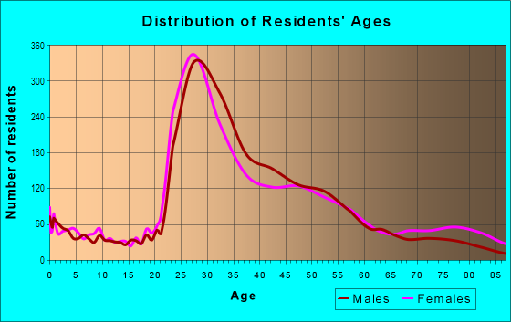
| Males: | 2,806 |
| Females: | 3,485 |
Males:
| This neighborhood: | 44.4 years |
| Whole city: | 34.4 years |
| This neighborhood: | 42.6 years |
| Whole city: | 34.7 years |
Average household size:
| Upper Kirby (Greenway): | 3.2 people |
| Houston: | 2.4 people |
Percentage of family households:
| Upper Kirby (Greenway): | 39.4% |
| Houston: | 43.0% |
| Here: | 36.8% |
| Houston: | 34.7% |
Percentage of married-couple families with children (among all households):
| Upper Kirby (Greenway): | 51.9% |
| Houston: | 23.3% |
Percentage of single-mother households (among all households):
| Upper Kirby (Greenway): | 20.3% |
| Houston: | 13.9% |
Percentage of never married males 15 years old and over:
Percentage of never married females 15 years old and over:
| Upper Kirby (Greenway): | 17.7% |
| Houston: | 22.9% |
Percentage of never married females 15 years old and over:
| Upper Kirby (Greenway): | 21.7% |
| city: | 21.2% |
Percentage of people that speak English not well or not at all:
| Upper Kirby (Greenway): | 6.9% |
| Houston: | 15.9% |
Percentage of people born in this state:
Percentage of people born in another U.S. state:
Percentage of native residents but born outside the U.S.:
Percentage of foreign born residents:
| Here: | 50.0% |
| Houston: | 51.1% |
Percentage of people born in another U.S. state:
| Upper Kirby (Greenway): | 31.4% |
| Houston: | 17.7% |
Percentage of native residents but born outside the U.S.:
| Here: | 2.0% |
| city: | 1.8% |
Percentage of foreign born residents:
| Here: | 16.6% |
| Houston: | 29.4% |

Owner-occupied
Renter-occupied


- Rooms in owner-occupied houses and condos in Upper Kirby <
> - 1911 room
- 02 rooms
- 903 rooms
- 784 rooms
- 3365 rooms
- 766 rooms
- 3247 rooms
- 8718 rooms
- 3,8539+ rooms

- Rooms in renter-occupied apartments in Upper Kirby <
> - 1501 room
- 2272 rooms
- 1,0343 rooms
- 8934 rooms
- 3785 rooms
- 2466 rooms
- 2577 rooms
- 838 rooms
- 2139+ rooms
Owner-occupied
Renter-occupied

- Bedrooms in owner-occupied houses and condos in Upper Kirby <
> - 191no bedroom
- 1611 bedroom
- 2472 bedrooms
- 2313 bedrooms
- 2,9714 bedrooms
- 9575+ bedrooms

- Bedrooms in renter-occupied apartments in Upper Kirby <
> - 150no bedroom
- 1,6441 bedroom
- 4972 bedrooms
- 2663 bedrooms
- 1154 bedrooms
- 3055+ bedrooms
Average number of cars or other vehicles available in houses/condos:
Average number of cars or other vehicles available in apartments:
| This neighborhood: | 1.0 |
| Houston: | 2.0 |
Average number of cars or other vehicles available in apartments:
| Here: | |
| city: |
Percentage of units with a mortgage:
| Upper Kirby (Greenway): | 63.3% |
| Houston: | 50.8% |
Average estimated value of detached houses in 2022 (22.9% of all units):
| Upper Kirby (Greenway): | $1,250,629 |
| Houston: | $368,067 |

- Year house built in Upper Kirby <
> - 3562020 or later
- 8012010 to 2019
- 1782000 to 2009
- 2391990 to 1999
- 2561980 to 1989
- 1,5291970 to 1979
- 1,3171960 to 1969
- 1281950 to 1959
- 9331940 to 1949
- 2801939 or earlier

City-data.com crime index for city in 2020 (higher means more crime):
| City: | 560.9 |
| U.S. average: | 219.5 |
Travel time to work (commute)
![Travel time to work (commute)]()
- 262Less than 5 minutes
- 1,1135 to 9 minutes
- 1,49710 to 14 minutes
- 2,55215 to 19 minutes
- 2,53120 to 24 minutes
- 67225 to 29 minutes
- 2,19230 to 34 minutes
- 16335 to 39 minutes
- 23640 to 44 minutes
- 44045 to 59 minutes
- 31060 to 89 minutes
- 49990 or more minutes

Means of transportation to work
![Means of transportation to work]()
- 86.4%3,316Drove a car alone
- 6.3%241Carpooled
- 4.7%180Bus
- 8.5%327Taxi
- 5.5%213Bicycle
- 3.8%146Walked
- 5.8%222Other means
- 42.1%1,615Worked at home

Time leaving home to go to work
![Time leaving home to go to work]()
- 14712:00 a.m. to 4:59 a.m.
- 5295:00 a.m. to 5:29 a.m.
- 1625:30 a.m. to 5:59 a.m.
- 3996:00 a.m. to 6:29 a.m.
- 6156:30 a.m. to 6:59 a.m.
- 1,5737:00 a.m. to 7:29 a.m.
- 2,4297:30 a.m. to 7:59 a.m.
- 2,2858:00 a.m. to 8:29 a.m.
- 5978:30 a.m. to 8:59 a.m.
- 1,1329:00 a.m. to 9:59 a.m.
- 86810:00 a.m. to 10:59 a.m.
- 9211:00 a.m. to 11:59 a.m.
- 99912:00 p.m. to 3:59 p.m.
- 3084:00 p.m. to 11:59 p.m.

Occupations of males:
- Percentage of males in management occupations (except farmers):
Here: 15.1% city: 10.6%
- Percentage of males in business and financial operations occupations:
Here: 8.4% city: 5.4%
- Percentage of males in computer and mathematical occupations:
Here: 4.6% city: 3.9%
- Percentage of males in architecture and engineering occupations:
Here: 12.6% city: 4.0%
- Percentage of males in community and social services occupations:
Here: 19.0% city: 0.7%
- Percentage of males in legal occupations:
Here: 1.4% city: 1.4%
- Percentage of males in arts, design, entertainment, sports, and media occupations:
Here: 3.2% city: 1.6%
- Percentage of males in healthcare practitioners and technical occupations:
Here: 2.7% city: 2.7%
- Percentage of males in sales and office occupations:
Here: 38.8% city: 13.5%
- Percentage of males in construction, extraction, and maintenance occupations:
Here: 5.3% city: 15.7%
- Percentage of males in production occupations:
Here: 5.2% city: 6.0%
- Percentage of males in transportation occupations:
Here: 1.7% city: 6.1%
Occupations of females:
- Percentage of females in management occupations (except farmers):
Here: 17.2% city: 8.6%
- Percentage of females in business and financial operations occupations:
Here: 7.4% city: 6.8%
- Percentage of females in architecture and engineering occupations:
Here: 3.3% city: 1.4%
- Percentage of females in legal occupations:
Here: 1.2% city: 2.0%
- Percentage of females in education, training, and library occupations:
Here: 6.2% city: 8.5%
- Percentage of females in healthcare practitioners and technical occupations:
Here: 1.4% city: 8.1%
- Percentage of females in service occupations:
Here: 8.1% city: 23.8%
- Percentage of females in sales and office occupations:
Here: 42.4% city: 26.6%
- Percentage of females in production occupations:
Here: 11.9% city: 2.6%
Percentage of people 16-64 in Armed Forces:
| Upper Kirby (Greenway): | 0.0% |
| Houston: | 0.1% |
Education in this neighborhood (subdivision or community):
- Percentage of people 3 years and older in K-12 schools:
Upper Kirby (Greenway): 41.3% Houston: 16.6%
- Percentage of people 3 years and older in undergraduate colleges:
Upper Kirby (Greenway): 10.7% Houston: 4.6%
- Percentage of people 3 years and older in grad. or professional schools:
Upper Kirby (Greenway): 8.8% Houston: 1.6%
- Percentage of students K-12 enrolled in private schools:
Upper Kirby (Greenway): 125.9% Houston: 9.0%
Percentage of population below poverty level:
| Upper Kirby (Greenway): | 6.1% |
| Houston: | 20.7% |
Median year owner moved in (as recorded in 2022):
| Upper Kirby (Greenway): | 2011 |
| Houston: | 2010 |
Percentage of married-couple families with both working:
| Upper Kirby (Greenway): | 86.5% |
| Houston: | 54.9% |

- 43.6%Electricity
- 42.3%Utility gas
- 4.4%Bottled, tank, or LP gas
- 4.1%Other fuel
- 2.8%Fuel oil, kerosene, etc.
- 2.8%No fuel used
Highways in this neighborhood:
US Hwy 59 (Southwest Fwy)
Length: 5.86 miles
Direction: E-W
Direction: E-W
59-Hov (US Hwy 59)
Length: 3.20 miles
Directions: E-W, SW-NE
Directions: E-W, SW-NE
Roads and streets:
Westpark Dr
Length: 2.83 miles
Direction: E-W
Address range: 400 to 4899
Direction: E-W
Address range: 400 to 4899
W Alabama St
Length: 2.72 miles
Direction: E-W
Address range: 1988 to 4099
Direction: E-W
Address range: 1988 to 4099
Richmond Ave
Length: 2.64 miles
Direction: E-W
Address range: 2000 to 4256
Direction: E-W
Address range: 2000 to 4256
Norfolk St
Length: 1.70 miles
Directions: E-W, N-S, SE-NW, SW-NE
Address range: 2100 to 4199
Directions: E-W, N-S, SE-NW, SW-NE
Address range: 2100 to 4199
Portsmouth St
Length: 1.59 miles
Directions: E-W, N-S, SW-NE
Address range: 2100 to 4299
Directions: E-W, N-S, SW-NE
Address range: 2100 to 4299
W Main St
Length: 1.46 miles
Directions: E-W, SE-NW
Address range: 2000 to 4099
Directions: E-W, SE-NW
Address range: 2000 to 4099
Colquitt St
Length: 1.35 miles
Direction: E-W
Address range: 2000 to 4099
Direction: E-W
Address range: 2000 to 4099
Weslayan St
Length: 1.32 miles
Direction: N-S
Address range: 2701 to 5599
Direction: N-S
Address range: 2701 to 5599
Purdue St
Length: 1.29 miles
Directions: E-W, N-S, SE-NW, SW-NE
Address range: 3200 to 4299
Directions: E-W, N-S, SE-NW, SW-NE
Address range: 3200 to 4299
Edloe St
Length: 1.29 miles
Directions: E-W, N-S, SE-NW, SW-NE
Address range: 2800 to 5399
Directions: E-W, N-S, SE-NW, SW-NE
Address range: 2800 to 5399
Kirby Dr
Length: 1.16 miles
Direction: N-S
Address range: 2600 to 5299
Direction: N-S
Address range: 2600 to 5299
Buffalo Speedway
Length: 1.13 miles
Direction: N-S
Address range: 2700 to 5279
Direction: N-S
Address range: 2700 to 5279
Branard St
Length: 1.10 miles
Directions: E-W, SE-NW
Address range: 2000 to 4099
Directions: E-W, SE-NW
Address range: 2000 to 4099
Westheimer Rd
Length: 1.06 miles
Direction: E-W
Address range: 2300 to 3399
Direction: E-W
Address range: 2300 to 3399
Drake St
Length: 0.97 miles
Directions: E-W, SE-NW, SW-NE
Address range: 3700 to 4299
Directions: E-W, SE-NW, SW-NE
Address range: 3700 to 4299
Childress St
Length: 0.94 miles
Directions: E-W, N-S, SE-NW, SW-NE
Address range: 3500 to 4399
Directions: E-W, N-S, SE-NW, SW-NE
Address range: 3500 to 4399
Sul Ross St
Length: 0.92 miles
Direction: E-W
Address range: 2000 to 4099
Direction: E-W
Address range: 2000 to 4099
Kipling St
Length: 0.87 miles
Directions: E-W, SW-NE
Address range: 2000 to 3699
Directions: E-W, SW-NE
Address range: 2000 to 3699
S Shepherd Dr
Length: 0.82 miles
Directions: N-S, SE-NW
Address range: 2600 to 3999
Directions: N-S, SE-NW
Address range: 2600 to 3999
Eastside St
Length: 0.73 miles
Directions: N-S, SE-NW
Address range: 2700 to 3899
Directions: N-S, SE-NW
Address range: 2700 to 3899
Bissonnet St
Length: 0.73 miles
Directions: E-W, SW-NE
Address range: 2600 to 3999
Directions: E-W, SW-NE
Address range: 2600 to 3999
Drexel Dr
Length: 0.73 miles
Direction: N-S
Address range: 2731 to 3899
Direction: N-S
Address range: 2731 to 3899
Greenbriar St
Length: 0.70 miles
Directions: E-W, N-S, SW-NE
Address range: 2800 to 3999
Directions: E-W, N-S, SW-NE
Address range: 2800 to 3999
Newcastle Dr (Newcastle St)
Length: 0.66 miles
Directions: N-S, SE-NW, SW-NE
Address range: 3800 to 5498
Directions: N-S, SE-NW, SW-NE
Address range: 3800 to 5498
Virginia St
Length: 0.66 miles
Directions: E-W, N-S, SE-NW, SW-NE
Address range: 2600 to 3999
Directions: E-W, N-S, SE-NW, SW-NE
Address range: 2600 to 3999
Cummins St
Length: 0.62 miles
Direction: N-S
Address range: 3000 to 3699
Direction: N-S
Address range: 3000 to 3699
Timmons Ln
Length: 0.61 miles
Direction: N-S
Address range: 3000 to 3999
Direction: N-S
Address range: 3000 to 3999
Mercer St
Length: 0.55 miles
Directions: N-S, SE-NW
Address range: 3100 to 5321
Directions: N-S, SE-NW
Address range: 3100 to 5321
Las Palmas St (Las Palmas Dr)
Length: 0.55 miles
Direction: N-S
Address range: 3000 to 3999
Direction: N-S
Address range: 3000 to 3999
Wakeforest St
Length: 0.54 miles
Direction: N-S
Address range: 3600 to 5199
Direction: N-S
Address range: 3600 to 5199
Ferndale St
Length: 0.51 miles
Direction: N-S
Address range: 2700 to 3399
Direction: N-S
Address range: 2700 to 3399
Suffolk Dr
Length: 0.50 miles
Direction: N-S
Address range: 2801 to 3599
Direction: N-S
Address range: 2801 to 3599
Revere St
Length: 0.50 miles
Direction: N-S
Address range: 2600 to 3799
Direction: N-S
Address range: 2600 to 3799
Audley St
Length: 0.49 miles
Direction: N-S
Address range: 3000 to 3899
Direction: N-S
Address range: 3000 to 3899
Greenway Plaza Dr
Length: 0.49 miles
Directions: E-W, N-S
Directions: E-W, N-S
Sackett St
Length: 0.48 miles
Direction: N-S
Address range: 2700 to 3399
Direction: N-S
Address range: 2700 to 3399
Bammel Ln
Length: 0.48 miles
Direction: N-S
Address range: 2700 to 3399
Direction: N-S
Address range: 2700 to 3399
Pin Oak Park
Length: 0.47 miles
Direction: E-W
Address range: 4700 to 4899
Direction: E-W
Address range: 4700 to 4899
Westerman St
Length: 0.44 miles
Directions: E-W, SW-NE
Address range: 3700 to 3899
Directions: E-W, SW-NE
Address range: 3700 to 3899
Essex Ln
Length: 0.41 miles
Direction: E-W
Address range: 3917 to 39665
Direction: E-W
Address range: 3917 to 39665
Lake St
Length: 0.39 miles
Direction: N-S
Address range: 3000 to 3899
Direction: N-S
Address range: 3000 to 3899
Argonne St
Length: 0.39 miles
Direction: N-S
Address range: 2634 to 3299
Direction: N-S
Address range: 2634 to 3299
Mc Duffie St
Length: 0.39 miles
Direction: N-S
Address range: 2600 to 4299
Direction: N-S
Address range: 2600 to 4299
Steele St
Length: 0.38 miles
Direction: E-W
Address range: 2200 to 2799
Direction: E-W
Address range: 2200 to 2799
Cameron St
Length: 0.38 miles
Directions: E-W, N-S, SW-NE
Address range: 2300 to 2799
Directions: E-W, N-S, SW-NE
Address range: 2300 to 2799
Law St
Length: 0.37 miles
Directions: E-W, SE-NW
Address range: 3800 to 4099
Directions: E-W, SE-NW
Address range: 3800 to 4099
Harold St
Length: 0.34 miles
Direction: E-W
Address range: 2000 to 2199
Direction: E-W
Address range: 2000 to 2199
Markham St
Length: 0.34 miles
Direction: E-W
Address range: 4000 to 4299
Direction: E-W
Address range: 4000 to 4299
Whitman St
Length: 0.34 miles
Direction: E-W
Address range: 4000 to 4299
Direction: E-W
Address range: 4000 to 4299
Rosamond St
Length: 0.33 miles
Direction: E-W
Address range: 2300 to 2799
Direction: E-W
Address range: 2300 to 2799
Wild Indigo
Length: 0.32 miles
Direction: E-W
Address range: 4600 to 4699
Direction: E-W
Address range: 4600 to 4699
Morningside Dr
Length: 0.32 miles
Directions: E-W, N-S, SE-NW
Address range: 3400 to 3999
Directions: E-W, N-S, SE-NW
Address range: 3400 to 3999
Alabama Ct
Length: 0.29 miles
Directions: E-W, N-S
Address range: 1 to 3226
Directions: E-W, N-S
Address range: 1 to 3226
Auden St
Length: 0.29 miles
Directions: N-S, SE-NW
Address range: 5000 to 5412
Directions: N-S, SE-NW
Address range: 5000 to 5412
Belmont
Length: 0.27 miles
Directions: E-W, N-S
Directions: E-W, N-S
Lp Central Dr
Length: 0.26 miles
Directions: E-W, N-S, SW-NE
Address range: 4700 to 4799
Directions: E-W, N-S, SW-NE
Address range: 4700 to 4799
Academy St
Length: 0.25 miles
Direction: N-S
Address range: 1098 to 5507
Direction: N-S
Address range: 1098 to 5507
Richton St
Length: 0.24 miles
Direction: E-W
Address range: 2300 to 2599
Direction: E-W
Address range: 2300 to 2599
Lexington St
Length: 0.24 miles
Direction: E-W
Address range: 2100 to 2899
Direction: E-W
Address range: 2100 to 2899
Pin Oak Pl
Length: 0.24 miles
Directions: E-W, N-S
Directions: E-W, N-S
Dincans St
Length: 0.22 miles
Direction: N-S
Address range: 4900 to 5299
Direction: N-S
Address range: 4900 to 5299
Westgate Dr (Westgate St)
Length: 0.22 miles
Directions: E-W, N-S, SE-NW
Address range: 2600 to 2899
Directions: E-W, N-S, SE-NW
Address range: 2600 to 2899
Abercrombe Pl
Length: 0.21 miles
Directions: E-W, SW-NE
Directions: E-W, SW-NE
Marquart St
Length: 0.21 miles
Direction: N-S
Address range: 3000 to 3499
Direction: N-S
Address range: 3000 to 3499
South Blvd
Length: 0.20 miles
Direction: E-W
Address range: 3000 to 3299
Direction: E-W
Address range: 3000 to 3299
Arena Dr
Length: 0.20 miles
Directions: E-W, N-S
Directions: E-W, N-S
Farnham St
Length: 0.17 miles
Direction: SW-NE
Address range: 3700 to 3899
Direction: SW-NE
Address range: 3700 to 3899
S Sandman St
Length: 0.17 miles
Direction: N-S
Address range: 3600 to 3899
Direction: N-S
Address range: 3600 to 3899
Marshall St
Length: 0.17 miles
Direction: E-W
Address range: 2000 to 2099
Direction: E-W
Address range: 2000 to 2099
Chatham Ln
Length: 0.15 miles
Direction: E-W
Address range: 4000 to 4099
Direction: E-W
Address range: 4000 to 4099
Huldy St
Length: 0.15 miles
Direction: N-S
Address range: 2700 to 3099
Direction: N-S
Address range: 2700 to 3099
Betsy Ln
Length: 0.15 miles
Direction: E-W
Address range: 4000 to 4099
Direction: E-W
Address range: 4000 to 4099
Elbert St
Length: 0.14 miles
Direction: E-W
Address range: 3000 to 3199
Direction: E-W
Address range: 3000 to 3199
North Blvd
Length: 0.14 miles
Direction: E-W
Address range: 2600 to 2799
Direction: E-W
Address range: 2600 to 2799
Plaza Dr
Length: 0.12 miles
Direction: N-S
Direction: N-S
Danville
Length: 0.12 miles
Direction: E-W
Address range: 3100 to 3199
Direction: E-W
Address range: 3100 to 3199
Cummins Green
Length: 0.11 miles
Direction: N-S
Direction: N-S
la Salle St
Length: 0.11 miles
Direction: N-S
Address range: 3300 to 3399
Direction: N-S
Address range: 3300 to 3399
Syracuse St
Length: 0.11 miles
Directions: N-S, SW-NE
Address range: 3700 to 3799
Directions: N-S, SW-NE
Address range: 3700 to 3799
Essex Green St
Length: 0.11 miles
Directions: E-W, N-S, SE-NW
Address range: 3816 to 3898
Directions: E-W, N-S, SE-NW
Address range: 3816 to 3898
City Club Dr
Length: 0.10 miles
Direction: E-W
Address range: 1 to 99
Direction: E-W
Address range: 1 to 99
Community Dr
Length: 0.10 miles
Direction: N-S
Address range: 4200 to 4399
Direction: N-S
Address range: 4200 to 4399
Fairmont St
Length: 0.10 miles
Direction: N-S
Address range: 5001 to 5099
Direction: N-S
Address range: 5001 to 5099
Joanel St
Length: 0.10 miles
Direction: N-S
Address range: 2800 to 2999
Direction: N-S
Address range: 2800 to 2999
Saint St
Length: 0.10 miles
Direction: N-S
Address range: 2800 to 2999
Direction: N-S
Address range: 2800 to 2999
Park
Length: 0.09 miles
Direction: N-S
Address range: 3600 to 3799
Direction: N-S
Address range: 3600 to 3799
Westchester St
Length: 0.09 miles
Direction: N-S
Address range: 5200 to 5265
Direction: N-S
Address range: 5200 to 5265
Essex Ter
Length: 0.09 miles
Directions: E-W, N-S, SW-NE
Address range: 2700 to 3820
Directions: E-W, N-S, SW-NE
Address range: 2700 to 3820
Newcastle St
Length: 0.08 miles
Direction: N-S
Address range: 5400 to 5499
Direction: N-S
Address range: 5400 to 5499
Edloe-Driveway
Length: 0.08 miles
Direction: SW-NE
Direction: SW-NE
Saint Pl
Length: 0.08 miles
Directions: E-W, N-S, SE-NW, SW-NE
Address range: 2920 to 2958
Directions: E-W, N-S, SE-NW, SW-NE
Address range: 2920 to 2958
E Greenway Plz
Length: 0.08 miles
Direction: N-S
Address range: 1 to 99
Direction: N-S
Address range: 1 to 99
Algerian Way
Length: 0.07 miles
Directions: E-W, SE-NW
Address range: 2500 to 2599
Directions: E-W, SE-NW
Address range: 2500 to 2599
Lomitas St
Length: 0.07 miles
Directions: N-S, SE-NW
Address range: 4500 to 4599
Directions: N-S, SE-NW
Address range: 4500 to 4599
Harper
Length: 0.07 miles
Direction: E-W
Address range: 3100 to 3199
Direction: E-W
Address range: 3100 to 3199
Philfall St
Length: 0.07 miles
Direction: E-W
Address range: 3000 to 3099
Direction: E-W
Address range: 3000 to 3099
Earl St
Length: 0.07 miles
Direction: E-W
Address range: 3000 to 3099
Direction: E-W
Address range: 3000 to 3099
County Cress Rd
Length: 0.07 miles
Direction: N-S
Direction: N-S
Length: 0.06 miles
Direction: N-S
Direction: N-S
Navajo
Length: 0.05 miles
Direction: N-S
Address range: 4900 to 4999
Direction: N-S
Address range: 4900 to 4999
Audley
Length: 0.03 miles
Direction: N-S
Direction: N-S
Mc Duffie
Length: 0.03 miles
Direction: N-S
Direction: N-S
Orleans
Length: 0.02 miles
Direction: N-S
Direction: N-S
Belmont St
Length: 0.02 miles
Direction: N-S
Address range: 5150 to 5161
Direction: N-S
Address range: 5150 to 5161
Railroad features:
Southern Pacific RR
Length: 3.75 miles
Directions: E-W, N-S, SE-NW, SW-NE
Directions: E-W, N-S, SE-NW, SW-NE