Untitled Polygon neighborhood in Columbus, Ohio (OH), 43209 detailed profile
Settings
X


Business Search - 14 Million verified businesses
Area: 3.370 square miles
Population: 20,801
Population density:
| Untitled Polygon: | 6,172 people per square mile |
| Columbus: | 4,320 people per square mile |

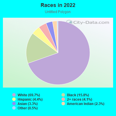
- 15,54469.7%White
- 3,52215.8%Black
- 9754.4%Hispanic or Latino
- 9044.1%Two or more races
- 7303.3%Asian
- 5132.3%American Indian
- 1020.5%Some other race
Distribution of median household income
![Distribution of median household income]()
- 441Less than $10,000
- 1,079$10,000 to $19,999
- 997$20,000 to $29,999
- 834$30,000 to $39,999
- 884$40,000 to $49,999
- 769$50,000 to $59,999
- 561$60,000 to $74,999
- 942$75,000 to $99,999
- 614$100,000 to $124,999
- 559$125,000 to $149,999
- 885$150,000 to $199,999
- 2,093$200,000 or more

Distribution of owner-occupied house/condo value
![Distribution of owner-occupied house/condo value]()
- 1,473Less than $50,000
- 1,390$50,000 to $99,999
- 789$100,000 to $149,999
- 933$150,000 to $199,999
- 610$200,000 to $249,999
- 387$250,000 to $299,999
- 1,201$300,000 to $399,999
- 1,337$400,000 to $499,999
- 1,126$500,000 to $749,999
- 922$750,000 to $999,999
- 1,322$1,000,000 or more

Distribution of rent paid by renters
![Distribution of rent paid by renters]()
- 223Less than $100
- 378$100 to $199
- 1,072$200 to $299
- 1,112$300 to $399
- 1,251$400 to $499
- 1,827$500 to $599
- 1,552$600 to $699
- 1,563$700 to $799
- 1,304$800 to $899
- 397$900 to $999
- 425$1,000 to $1,249
- 368$1,250 to $1,499
- 247$1,500 to $1,999
- 895$2,000 or more

| Males: | 10,037 |
| Females: | 10,763 |
Males:
| This neighborhood: | 37.2 years |
| Whole city: | 32.9 years |
| This neighborhood: | 38.9 years |
| Whole city: | 33.7 years |
Average household size:
| Untitled Polygon: | 3.4 people |
| Columbus: | 2.3 people |
Percentage of family households:
| Untitled Polygon: | 50.6% |
| Columbus: | 40.8% |
| Here: | 48.8% |
| Columbus: | 30.8% |
Percentage of married-couple families with children (among all households):
| Untitled Polygon: | 31.0% |
| Columbus: | 23.7% |
Percentage of single-mother households (among all households):
| Untitled Polygon: | 9.8% |
| Columbus: | 15.7% |
Percentage of never married males 15 years old and over:
Percentage of never married females 15 years old and over:
| Untitled Polygon: | 18.2% |
| Columbus: | 24.6% |
Percentage of never married females 15 years old and over:
| Untitled Polygon: | 17.7% |
| city: | 21.9% |
Percentage of people that speak English not well or not at all:
| Untitled Polygon: | 1.3% |
| Columbus: | 3.5% |
Percentage of people born in this state:
Percentage of people born in another U.S. state:
Percentage of native residents but born outside the U.S.:
Percentage of foreign born residents:
| Here: | 65.7% |
| Columbus: | 61.6% |
Percentage of people born in another U.S. state:
| Untitled Polygon: | 26.5% |
| Columbus: | 22.4% |
Percentage of native residents but born outside the U.S.:
| Here: | 1.6% |
| city: | 1.3% |
Percentage of foreign born residents:
| Here: | 6.4% |
| Columbus: | 14.7% |
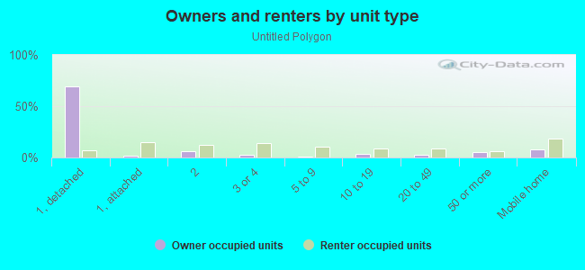
Owner-occupied
Renter-occupied

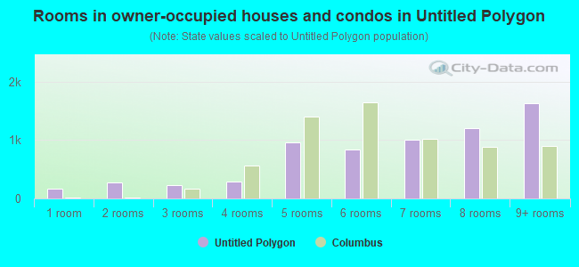
- Rooms in owner-occupied houses and condos in Untitled Polygon
- 1661 room
- 2812 rooms
- 2353 rooms
- 2904 rooms
- 9655 rooms
- 8376 rooms
- 1,0147 rooms
- 1,1998 rooms
- 1,6399+ rooms
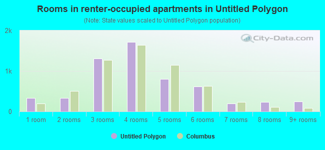
- Rooms in renter-occupied apartments in Untitled Polygon
- 3321 room
- 3372 rooms
- 1,3083 rooms
- 1,7144 rooms
- 8055 rooms
- 6206 rooms
- 2017 rooms
- 2368 rooms
- 2529+ rooms
Owner-occupied
Renter-occupied
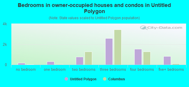
- Bedrooms in owner-occupied houses and condos in Untitled Polygon
- 161no bedroom
- 3121 bedroom
- 7712 bedrooms
- 2,5953 bedrooms
- 1,5234 bedrooms
- 8115+ bedrooms
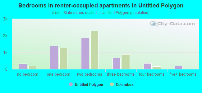
- Bedrooms in renter-occupied apartments in Untitled Polygon
- 332no bedroom
- 1,3941 bedroom
- 1,8732 bedrooms
- 6723 bedrooms
- 3504 bedrooms
- 1845+ bedrooms
Average number of cars or other vehicles available in houses/condos:
Average number of cars or other vehicles available in apartments:
| This neighborhood: | |
| Columbus: |
Average number of cars or other vehicles available in apartments:
| Here: | |
| city: |
Percentage of units with a mortgage:
| Untitled Polygon: | 71.3% |
| Columbus: | 69.3% |
Average estimated value of detached houses in 2022 (64.8% of all units):
| Untitled Polygon: | $287,166 |
| Columbus: | $262,671 |
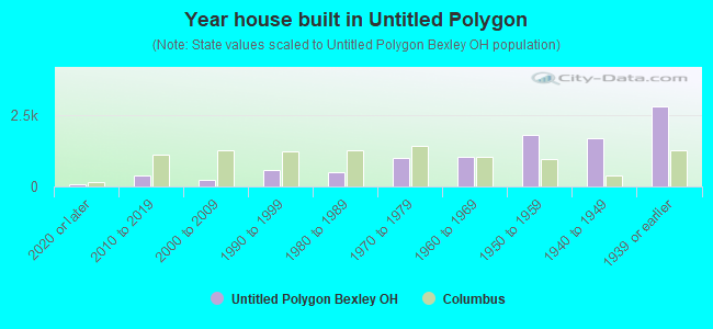
- Year house built in Untitled Polygon
- 702020 or later
- 3952010 to 2019
- 2342000 to 2009
- 5851990 to 1999
- 5171980 to 1989
- 1,0081970 to 1979
- 1,0291960 to 1969
- 1,8101950 to 1959
- 1,7021940 to 1949
- 2,8001939 or earlier
City-data.com crime index for city in 2020 (higher means more crime):
| City: | 376.1 |
| U.S. average: | 219.5 |
Travel time to work (commute)
![Travel time to work (commute)]()
- 339Less than 5 minutes
- 1,0945 to 9 minutes
- 1,37610 to 14 minutes
- 2,22315 to 19 minutes
- 1,48420 to 24 minutes
- 60325 to 29 minutes
- 74130 to 34 minutes
- 18435 to 39 minutes
- 20040 to 44 minutes
- 47945 to 59 minutes
- 30060 to 89 minutes
- 10090 or more minutes

Means of transportation to work
![Means of transportation to work]()
- 70.0%7,252Drove a car alone
- 6.2%640Carpooled
- 5.1%524Bus
- 0.8%86Light rail, streetcar or trolley
- 0.7%70Taxi
- 3.0%311Motorcycle
- 2.2%223Bicycle
- 6.4%659Walked
- 4.6%472Other means
- 16.5%1,710Worked at home

Time leaving home to go to work
![Time leaving home to go to work]()
- 26012:00 a.m. to 4:59 a.m.
- 1375:00 a.m. to 5:29 a.m.
- 1755:30 a.m. to 5:59 a.m.
- 3896:00 a.m. to 6:29 a.m.
- 7316:30 a.m. to 6:59 a.m.
- 1,0267:00 a.m. to 7:29 a.m.
- 1,3077:30 a.m. to 7:59 a.m.
- 1,3058:00 a.m. to 8:29 a.m.
- 8118:30 a.m. to 8:59 a.m.
- 8339:00 a.m. to 9:59 a.m.
- 36510:00 a.m. to 10:59 a.m.
- 22111:00 a.m. to 11:59 a.m.
- 58912:00 p.m. to 3:59 p.m.
- 4744:00 p.m. to 11:59 p.m.

Occupations of males:
- Percentage of males in management occupations (except farmers):
Here: 17.0% city: 10.2%
- Percentage of males in business and financial operations occupations:
Here: 10.8% city: 6.2%
- Percentage of males in computer and mathematical occupations:
Here: 3.8% city: 7.7%
- Percentage of males in architecture and engineering occupations:
Here: 2.1% city: 2.8%
- Percentage of males in life, physical, and social science occupations:
Here: 1.5% city: 1.1%
- Percentage of males in legal occupations:
Here: 4.5% city: 1.1%
- Percentage of males in education, training, and library occupations:
Here: 8.2% city: 3.8%
- Percentage of males in arts, design, entertainment, sports, and media occupations:
Here: 3.0% city: 2.1%
- Percentage of males in healthcare practitioners and technical occupations:
Here: 5.4% city: 2.9%
- Percentage of males in service occupations:
Here: 8.4% city: 13.8%
- Percentage of males in sales and office occupations:
Here: 16.9% city: 17.0%
- Percentage of males in construction, extraction, and maintenance occupations:
Here: 3.3% city: 5.2%
- Percentage of males in production occupations:
Here: 3.3% city: 6.5%
- Percentage of males in transportation occupations:
Here: 6.2% city: 6.4%
- Percentage of males in material moving occupations:
Here: 4.0% city: 7.9%
Occupations of females:
- Percentage of females in management occupations (except farmers):
Here: 15.8% city: 10.0%
- Percentage of females in business and financial operations occupations:
Here: 7.6% city: 8.2%
- Percentage of females in computer and mathematical occupations:
Here: 1.1% city: 2.6%
- Percentage of females in community and social services occupations:
Here: 4.4% city: 3.0%
- Percentage of females in legal occupations:
Here: 1.8% city: 1.3%
- Percentage of females in education, training, and library occupations:
Here: 15.0% city: 7.9%
- Percentage of females in arts, design, entertainment, sports, and media occupations:
Here: 3.8% city: 2.1%
- Percentage of females in healthcare practitioners and technical occupations:
Here: 11.5% city: 10.2%
- Percentage of females in service occupations:
Here: 13.4% city: 19.3%
- Percentage of females in sales and office occupations:
Here: 21.1% city: 25.0%
- Percentage of females in production occupations:
Here: 2.9% city: 3.0%
Percentage of people 16-64 in Armed Forces:
| Untitled Polygon: | 0.1% |
| Columbus: | 0.2% |
Education in this neighborhood (subdivision or community):
- Percentage of people 3 years and older in K-12 schools:
Untitled Polygon: 24.3% Columbus: 15.2%
- Percentage of people 3 years and older in undergraduate colleges:
Untitled Polygon: 12.0% Columbus: 6.7%
- Percentage of people 3 years and older in grad. or professional schools:
Untitled Polygon: 3.0% Columbus: 2.4%
- Percentage of students K-12 enrolled in private schools:
Untitled Polygon: 54.9% Columbus: 13.8%
Percentage of population below poverty level:
| Untitled Polygon: | 7.5% |
| Columbus: | 18.1% |
Percentage of married-couple families with both working:
| Untitled Polygon: | 81.9% |
| Columbus: | 75.5% |
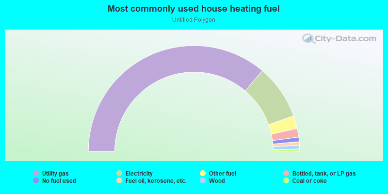
- 72.4%Utility gas
- 16.7%Electricity
- 4.0%Other fuel
- 2.6%Bottled, tank, or LP gas
- 1.4%No fuel used
- 1.1%Fuel oil, kerosene, etc.
- 1.1%Wood
- 0.7%Coal or coke
Highways in this neighborhood:
US Hwy 40 (E Broad St)
Length: 2.12 miles
Direction: E-W
Address range: 1899 to 3046
Direction: E-W
Address range: 1899 to 3046
US Hwy 33 (E Livingston Ave)
Length: 1.51 miles
Direction: E-W
Address range: 2049 to 2850
Direction: E-W
Address range: 2049 to 2850
US Hwy 40 (S Drexel Ave)
Length: 0.85 miles
Direction: N-S
Address range: 1 to 598
Direction: N-S
Address range: 1 to 598
Roads and streets:
Bryden Rd
Length: 1.61 miles
Direction: E-W
Address range: 2100 to 2954
Direction: E-W
Address range: 2100 to 2954
Maryland Ave
Length: 1.60 miles
Direction: E-W
Address range: 2281 to 3141
Direction: E-W
Address range: 2281 to 3141
E Main St
Length: 1.60 miles
Direction: E-W
Address range: 2083 to 2936
Direction: E-W
Address range: 2083 to 2936
S Roosevelt Ave
Length: 1.59 miles
Direction: N-S
Address range: 1 to 1078
Direction: N-S
Address range: 1 to 1078
S Cassingham Rd
Length: 1.55 miles
Direction: N-S
Address range: 1 to 1048
Direction: N-S
Address range: 1 to 1048
Dale Ave
Length: 1.45 miles
Directions: E-W, SW-NE
Address range: 2115 to 2958
Directions: E-W, SW-NE
Address range: 2115 to 2958
Fair Ave
Length: 1.44 miles
Direction: E-W
Address range: 2022 to 2998
Direction: E-W
Address range: 2022 to 2998
S Remington Rd
Length: 1.39 miles
Direction: N-S
Address range: 1 to 1058
Direction: N-S
Address range: 1 to 1058
E Mound St
Length: 1.38 miles
Direction: E-W
Address range: 2145 to 2904
Direction: E-W
Address range: 2145 to 2904
Powell Ave
Length: 1.37 miles
Direction: E-W
Address range: 2153 to 2864
Direction: E-W
Address range: 2153 to 2864
Denver Ave
Length: 1.30 miles
Directions: E-W, SE-NW
Address range: 2440 to 3113
Directions: E-W, SE-NW
Address range: 2440 to 3113
Ruhl Ave
Length: 1.27 miles
Direction: E-W
Address range: 2339 to 3159
Direction: E-W
Address range: 2339 to 3159
Sherwood Rd
Length: 1.25 miles
Direction: E-W
Address range: 2288 to 2949
Direction: E-W
Address range: 2288 to 2949
Bexley Park Rd
Length: 1.25 miles
Direction: E-W
Address range: 2315 to 2957
Direction: E-W
Address range: 2315 to 2957
S Chesterfield Rd
Length: 1.19 miles
Directions: N-S, SE-NW, SW-NE
Address range: 1 to 975
Directions: N-S, SE-NW, SW-NE
Address range: 1 to 975
Astor Ave
Length: 1.18 miles
Direction: E-W
Address range: 2095 to 2859
Direction: E-W
Address range: 2095 to 2859
S Broadleigh Rd
Length: 1.15 miles
Directions: N-S, SW-NE
Address range: 1 to 1005
Directions: N-S, SW-NE
Address range: 1 to 1005
S Gould Rd
Length: 0.97 miles
Direction: N-S
Address range: 1 to 659
Direction: N-S
Address range: 1 to 659
Charles St
Length: 0.94 miles
Directions: E-W, N-S, SE-NW
Address range: 2104 to 2702
Directions: E-W, N-S, SE-NW
Address range: 2104 to 2702
Brentwood Rd
Length: 0.94 miles
Direction: E-W
Address range: 2328 to 2865
Direction: E-W
Address range: 2328 to 2865
Clifton Ave
Length: 0.89 miles
Direction: E-W
Address range: 1998 to 2456
Direction: E-W
Address range: 1998 to 2456
S Cassady Ave
Length: 0.88 miles
Direction: N-S
Address range: 1 to 577
Direction: N-S
Address range: 1 to 577
S Dawson Ave
Length: 0.86 miles
Direction: N-S
Address range: 1 to 576
Direction: N-S
Address range: 1 to 576
N Columbia Ave
Length: 0.86 miles
Directions: N-S, SW-NE
Address range: 1 to 559
Directions: N-S, SW-NE
Address range: 1 to 559
N Cassady Ave
Length: 0.84 miles
Direction: N-S
Address range: 1 to 557
Direction: N-S
Address range: 1 to 557
N Drexel Ave
Length: 0.83 miles
Direction: N-S
Address range: 1 to 557
Direction: N-S
Address range: 1 to 557
N Cassingham Rd
Length: 0.81 miles
Directions: N-S, SW-NE
Address range: 1 to 533
Directions: N-S, SW-NE
Address range: 1 to 533
N Parkview Ave
Length: 0.81 miles
Directions: N-S, SW-NE
Address range: 1 to 545
Directions: N-S, SW-NE
Address range: 1 to 545
S Parkview Ave
Length: 0.81 miles
Direction: N-S
Address range: 1 to 533
Direction: N-S
Address range: 1 to 533
N Stanwood Rd
Length: 0.78 miles
Directions: N-S, SE-NW
Address range: 1 to 544
Directions: N-S, SE-NW
Address range: 1 to 544
Park Dr
Length: 0.75 miles
Directions: E-W, N-S, SE-NW, SW-NE
Address range: 1 to 898
Directions: E-W, N-S, SE-NW, SW-NE
Address range: 1 to 898
N Roosevelt Ave
Length: 0.74 miles
Directions: E-W, N-S
Address range: 1 to 411
Directions: E-W, N-S
Address range: 1 to 411
Elm Ave
Length: 0.74 miles
Directions: E-W, SW-NE
Address range: 2400 to 2850
Directions: E-W, SW-NE
Address range: 2400 to 2850
Delmar Dr
Length: 0.73 miles
Direction: E-W
Address range: 2453 to 2874
Direction: E-W
Address range: 2453 to 2874
Stanbery Ave
Length: 0.71 miles
Direction: N-S
Address range: 1 to 599
Direction: N-S
Address range: 1 to 599
N Gould Rd
Length: 0.70 miles
Directions: E-W, N-S
Address range: 1 to 454
Directions: E-W, N-S
Address range: 1 to 454
S Columbia Ave
Length: 0.70 miles
Direction: N-S
Address range: 1 to 461
Direction: N-S
Address range: 1 to 461
S Harding Rd
Length: 0.68 miles
Direction: N-S
Address range: 1 to 456
Direction: N-S
Address range: 1 to 456
Kenwick Rd
Length: 0.67 miles
Directions: N-S, SE-NW
Address range: 660 to 1109
Directions: N-S, SE-NW
Address range: 660 to 1109
Westland Ave
Length: 0.67 miles
Directions: N-S, SE-NW, SW-NE
Address range: 1 to 440
Directions: N-S, SE-NW, SW-NE
Address range: 1 to 440
College Ave
Length: 0.66 miles
Direction: N-S
Address range: 551 to 999
Direction: N-S
Address range: 551 to 999
Sheridan Ave
Length: 0.66 miles
Direction: N-S
Address range: 555 to 999
Direction: N-S
Address range: 555 to 999
Chelsea Ave
Length: 0.65 miles
Direction: N-S
Address range: 651 to 1099
Direction: N-S
Address range: 651 to 1099
Grandon Ave
Length: 0.65 miles
Direction: N-S
Address range: 646 to 1099
Direction: N-S
Address range: 646 to 1099
Vernon Rd
Length: 0.64 miles
Direction: N-S
Address range: 645 to 1099
Direction: N-S
Address range: 645 to 1099
Montrose Ave
Length: 0.64 miles
Direction: N-S
Address range: 625 to 1048
Direction: N-S
Address range: 625 to 1048
Euclaire Ave
Length: 0.63 miles
Direction: N-S
Address range: 585 to 1029
Direction: N-S
Address range: 585 to 1029
S Merkle Rd
Length: 0.63 miles
Directions: N-S, SE-NW
Address range: 1 to 416
Directions: N-S, SE-NW
Address range: 1 to 416
Pleasant Ridge Ave
Length: 0.62 miles
Directions: E-W, N-S, SE-NW
Address range: 589 to 1000
Directions: E-W, N-S, SE-NW
Address range: 589 to 1000
Allegheny Ave
Length: 0.60 miles
Direction: E-W
Address range: 2663 to 3139
Direction: E-W
Address range: 2663 to 3139
S Stanwood Rd
Length: 0.59 miles
Direction: N-S
Address range: 1 to 372
Direction: N-S
Address range: 1 to 372
N Ardmore Rd
Length: 0.57 miles
Direction: N-S
Address range: 1 to 385
Direction: N-S
Address range: 1 to 385
Bellwood Ave
Length: 0.57 miles
Directions: E-W, SE-NW
Address range: 2669 to 2949
Directions: E-W, SE-NW
Address range: 2669 to 2949
S Ardmore Rd
Length: 0.55 miles
Direction: N-S
Address range: 1 to 354
Direction: N-S
Address range: 1 to 354
N Remington Rd
Length: 0.54 miles
Direction: N-S
Address range: 1 to 357
Direction: N-S
Address range: 1 to 357
Caroline Ave
Length: 0.54 miles
Directions: E-W, SW-NE
Address range: 2360 to 2649
Directions: E-W, SW-NE
Address range: 2360 to 2649
N Chesterfield Rd
Length: 0.52 miles
Directions: E-W, N-S, SW-NE
Address range: 1 to 379
Directions: E-W, N-S, SW-NE
Address range: 1 to 379
Enfield Rd
Length: 0.52 miles
Directions: N-S, SE-NW, SW-NE
Address range: 460 to 951
Directions: N-S, SE-NW, SW-NE
Address range: 460 to 951
Francis Ave
Length: 0.49 miles
Direction: N-S
Address range: 700 to 1030
Direction: N-S
Address range: 700 to 1030
Ashbourne Rd
Length: 0.47 miles
Directions: E-W, N-S, SE-NW, SW-NE
Address range: 16 to 281
Directions: E-W, N-S, SE-NW, SW-NE
Address range: 16 to 281
North Virginia Lee Rd
Length: 0.43 miles
Direction: N-S
Address range: 50 to 349
Direction: N-S
Address range: 50 to 349
Preston Rd
Length: 0.42 miles
Direction: N-S
Address range: 1 to 274
Direction: N-S
Address range: 1 to 274
Elm St
Length: 0.41 miles
Direction: E-W
Address range: 2203 to 2406
Direction: E-W
Address range: 2203 to 2406
Columbus Ave
Length: 0.40 miles
Direction: E-W
Address range: 2639 to 2929
Direction: E-W
Address range: 2639 to 2929
N Merkle Rd
Length: 0.37 miles
Direction: N-S
Address range: 1 to 240
Direction: N-S
Address range: 1 to 240
N Broadleigh Rd
Length: 0.34 miles
Direction: N-S
Address range: 1 to 224
Direction: N-S
Address range: 1 to 224
Northview Dr
Length: 0.33 miles
Direction: N-S
Address range: 339 to 554
Direction: N-S
Address range: 339 to 554
N Harding Rd
Length: 0.31 miles
Direction: N-S
Address range: 1 to 211
Direction: N-S
Address range: 1 to 211
Brownlee Ave
Length: 0.31 miles
Direction: E-W
Address range: 2700 to 2878
Direction: E-W
Address range: 2700 to 2878
Plymouth Ave
Length: 0.29 miles
Direction: E-W
Address range: 2387 to 2799
Direction: E-W
Address range: 2387 to 2799
Boston Ave
Length: 0.29 miles
Direction: E-W
Address range: 2200 to 2399
Direction: E-W
Address range: 2200 to 2399
Commonwealth Park S
Length: 0.29 miles
Direction: E-W
Address range: 2269 to 2420
Direction: E-W
Address range: 2269 to 2420
Commonwealth Park N
Length: 0.28 miles
Direction: E-W
Address range: 2278 to 2420
Direction: E-W
Address range: 2278 to 2420
Eastminster Rd
Length: 0.28 miles
Directions: E-W, SW-NE
Address range: 2700 to 2866
Directions: E-W, SW-NE
Address range: 2700 to 2866
Elbern Ave
Length: 0.26 miles
Direction: E-W
Address range: 2928 to 3051
Direction: E-W
Address range: 2928 to 3051
Sessions Dr
Length: 0.25 miles
Directions: E-W, N-S, SW-NE
Address range: 1 to 40
Directions: E-W, N-S, SW-NE
Address range: 1 to 40
Etna St
Length: 0.25 miles
Direction: E-W
Address range: 2859 to 2999
Direction: E-W
Address range: 2859 to 2999
Barclay Sq
Length: 0.24 miles
Directions: E-W, N-S
Address range: 2853 to 3008
Directions: E-W, N-S
Address range: 2853 to 3008
Stanbery Dr
Length: 0.22 miles
Directions: E-W, N-S, SE-NW, SW-NE
Address range: 436 to 2618
Directions: E-W, N-S, SE-NW, SW-NE
Address range: 436 to 2618
South Virginia Lee Rd
Length: 0.21 miles
Direction: N-S
Address range: 62 to 298
Direction: N-S
Address range: 62 to 298
Parkland Pl
Length: 0.20 miles
Directions: E-W, N-S, SW-NE
Address range: 2716 to 2828
Directions: E-W, N-S, SW-NE
Address range: 2716 to 2828
Bellwood Ct
Length: 0.19 miles
Directions: E-W, N-S
Address range: 3000 to 3199
Directions: E-W, N-S
Address range: 3000 to 3199
Ashbourne Pl
Length: 0.19 miles
Directions: E-W, N-S, SE-NW, SW-NE
Address range: 219 to 328
Directions: E-W, N-S, SE-NW, SW-NE
Address range: 219 to 328
Village Creek Dr
Length: 0.17 miles
Directions: E-W, N-S
Address range: 801 to 899
Directions: E-W, N-S
Address range: 801 to 899
Barclay Sq N
Length: 0.17 miles
Direction: E-W
Address range: 2891 to 3014
Direction: E-W
Address range: 2891 to 3014
Barton Pl
Length: 0.17 miles
Direction: E-W
Address range: 2038 to 2125
Direction: E-W
Address range: 2038 to 2125
North Virginia Lee Rd W
Length: 0.17 miles
Directions: E-W, N-S, SE-NW
Address range: 301 to 499
Directions: E-W, N-S, SE-NW
Address range: 301 to 499
Bullitt Park Pl
Length: 0.16 miles
Direction: N-S
Address range: 1 to 99
Direction: N-S
Address range: 1 to 99
Kingsbury Pl
Length: 0.16 miles
Direction: N-S
Address range: 1030 to 1123
Direction: N-S
Address range: 1030 to 1123
Seneca Park Pl
Length: 0.16 miles
Direction: E-W
Address range: 2429 to 2499
Direction: E-W
Address range: 2429 to 2499
Bexford Pl
Length: 0.15 miles
Direction: E-W
Address range: 2457 to 2512
Direction: E-W
Address range: 2457 to 2512
Chesterfield Ct
Length: 0.14 miles
Directions: E-W, SE-NW
Address range: 2998 to 3074
Directions: E-W, SE-NW
Address range: 2998 to 3074
Barclay Sq S
Length: 0.14 miles
Direction: E-W
Address range: 445 to 2999
Direction: E-W
Address range: 445 to 2999
Meadow Park Ave
Length: 0.12 miles
Direction: N-S
Address range: 1 to 99
Direction: N-S
Address range: 1 to 99
Eastmoor Blvd
Length: 0.12 miles
Direction: SE-NW
Address range: 1 to 99
Direction: SE-NW
Address range: 1 to 99
Sheridon Park Ct
Length: 0.11 miles
Directions: E-W, N-S, SE-NW
Address range: 755 to 830
Directions: E-W, N-S, SE-NW
Address range: 755 to 830
Parkhill Dr
Length: 0.11 miles
Direction: E-W
Address range: 2067 to 2120
Direction: E-W
Address range: 2067 to 2120
Mayfield Pl
Length: 0.10 miles
Direction: N-S
Address range: 900 to 999
Direction: N-S
Address range: 900 to 999
Ferndale Pl
Length: 0.10 miles
Direction: N-S
Address range: 900 to 1004
Direction: N-S
Address range: 900 to 1004
Roosevelt Ct
Length: 0.10 miles
Direction: E-W
Address range: 2799 to 2994
Direction: E-W
Address range: 2799 to 2994
Dana Dr
Length: 0.09 miles
Direction: E-W
Address range: 2927 to 3004
Direction: E-W
Address range: 2927 to 3004
Havenwood Dr N
Length: 0.09 miles
Directions: E-W, SE-NW
Address range: 2385 to 2436
Directions: E-W, SE-NW
Address range: 2385 to 2436
Eastmoreland Dr
Length: 0.09 miles
Direction: E-W
Address range: 2755 to 2821
Direction: E-W
Address range: 2755 to 2821
Havenwood Dr S
Length: 0.09 miles
Directions: E-W, SE-NW
Address range: 2387 to 2426
Directions: E-W, SE-NW
Address range: 2387 to 2426
Browning Ave
Length: 0.08 miles
Directions: N-S, SW-NE
Address range: 1072 to 1123
Directions: N-S, SW-NE
Address range: 1072 to 1123
Van Heyde Pl
Length: 0.08 miles
Direction: N-S
Address range: 480 to 549
Direction: N-S
Address range: 480 to 549
Virginialee Rd E
Length: 0.08 miles
Directions: E-W, SW-NE
Address range: 300 to 375
Directions: E-W, SW-NE
Address range: 300 to 375
Janet Cir
Length: 0.07 miles
Direction: E-W
Address range: 2933 to 2982
Direction: E-W
Address range: 2933 to 2982
Bishop Sq
Length: 0.07 miles
Directions: N-S, SE-NW, SW-NE
Address range: 1 to 199
Directions: N-S, SE-NW, SW-NE
Address range: 1 to 199
Franklin Park S
Length: 0.07 miles
Direction: E-W
Address range: 1984 to 2021
Direction: E-W
Address range: 1984 to 2021
Barclay Sq E
Length: 0.06 miles
Direction: N-S
Address range: 431 to 487
Direction: N-S
Address range: 431 to 487
Barclay Sq W
Length: 0.06 miles
Direction: N-S
Address range: 439 to 499
Direction: N-S
Address range: 439 to 499
Westland Ct
Length: 0.05 miles
Directions: E-W, N-S
Directions: E-W, N-S
Lyons Gate
Length: 0.04 miles
Direction: N-S
Address range: 1 to 99
Direction: N-S
Address range: 1 to 99
Compson Ln
Length: 0.04 miles
Direction: N-S
Address range: 389 to 412
Direction: N-S
Address range: 389 to 412
Columbia Pl
Length: 0.04 miles
Direction: N-S
Address range: 473 to 512
Direction: N-S
Address range: 473 to 512
Reynolds Ln
Length: 0.03 miles
Direction: N-S
Address range: 391 to 410
Direction: N-S
Address range: 391 to 410
Virginialee Rd W
Length: 0.03 miles
Direction: E-W
Direction: E-W
Railroad features:
Conrail RR (Csx RR)
Length: 0.20 miles
Direction: E-W
Direction: E-W