Trinity (Houston Gardens) neighborhood in Houston, Texas (TX), 77016, 77026, 77028 detailed profile
Settings
X


Business Search - 14 Million verified businesses
Area: 6.854 square miles
Population: 21,781
Population density:
| Trinity (Houston Gardens): | 3,178 people per square mile |
| Houston: | 3,977 people per square mile |

- 11,72351.0%Black
- 9,38940.8%Hispanic or Latino
- 4892.1%White
- 4542.0%Two or more races
- 3861.7%Asian
- 3261.4%Some other race
- 2291.0%American Indian

Distribution of median household income
![Distribution of median household income]()
- 927Less than $10,000
- 1,440$10,000 to $19,999
- 1,294$20,000 to $29,999
- 1,236$30,000 to $39,999
- 1,310$40,000 to $49,999
- 792$50,000 to $59,999
- 981$60,000 to $74,999
- 748$75,000 to $99,999
- 544$100,000 to $124,999
- 367$125,000 to $149,999
- 599$150,000 to $199,999
- 246$200,000 or more

Distribution of owner-occupied house/condo value
![Distribution of owner-occupied house/condo value]()
- 2,101Less than $50,000
- 3,021$50,000 to $99,999
- 1,622$100,000 to $149,999
- 955$150,000 to $199,999
- 530$200,000 to $249,999
- 218$250,000 to $299,999
- 128$300,000 to $399,999
- 187$400,000 to $499,999
- 250$750,000 to $999,999
- 237$1,000,000 or more

Distribution of rent paid by renters
![Distribution of rent paid by renters]()
- 139Less than $100
- 482$100 to $199
- 770$200 to $299
- 871$300 to $399
- 943$400 to $499
- 1,314$500 to $599
- 1,542$600 to $699
- 1,272$700 to $799
- 506$800 to $899
- 671$900 to $999
- 615$1,000 to $1,249
- 1,063$1,250 to $1,499
- 300$1,500 to $1,999
- 658$2,000 or more

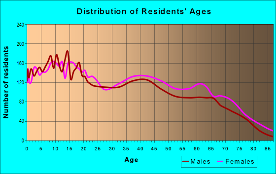
| Males: | 10,833 |
| Females: | 10,948 |
Males:
| This neighborhood: | 37.6 years |
| Whole city: | 34.4 years |
| This neighborhood: | 38.6 years |
| Whole city: | 34.7 years |
Average household size:
| Trinity (Houston Gardens): | 4.5 people |
| Houston: | 2.4 people |
Percentage of family households:
| Trinity (Houston Gardens): | 48.0% |
| Houston: | 43.0% |
| Here: | 27.0% |
| Houston: | 34.7% |
Percentage of married-couple families with children (among all households):
| Trinity (Houston Gardens): | 18.9% |
| Houston: | 23.3% |
Percentage of single-mother households (among all households):
| Trinity (Houston Gardens): | 19.0% |
| Houston: | 13.9% |
Percentage of never married males 15 years old and over:
Percentage of never married females 15 years old and over:
| Trinity (Houston Gardens): | 26.4% |
| Houston: | 22.9% |
Percentage of never married females 15 years old and over:
| Trinity (Houston Gardens): | 22.8% |
| city: | 21.2% |
Percentage of people that speak English not well or not at all:
| Trinity (Houston Gardens): | 13.5% |
| Houston: | 15.9% |
Percentage of people born in this state:
Percentage of people born in another U.S. state:
Percentage of native residents but born outside the U.S.:
Percentage of foreign born residents:
| Here: | 71.4% |
| Houston: | 51.1% |
Percentage of people born in another U.S. state:
| Trinity (Houston Gardens): | 7.9% |
| Houston: | 17.7% |
Percentage of native residents but born outside the U.S.:
| Here: | 0.7% |
| city: | 1.8% |
Percentage of foreign born residents:
| Here: | 20.5% |
| Houston: | 29.4% |

Owner-occupied
Renter-occupied


- Rooms in owner-occupied houses and condos in Trinity <
> - 1761 room
- 432 rooms
- 5283 rooms
- 4554 rooms
- 1,1945 rooms
- 1,5066 rooms
- 4597 rooms
- 3088 rooms
- 2809+ rooms

- Rooms in renter-occupied apartments in Trinity <
> - 3041 room
- 3262 rooms
- 6853 rooms
- 1,2104 rooms
- 1,2545 rooms
- 7616 rooms
- 1,0577 rooms
- 2388 rooms
- 1229+ rooms
Owner-occupied
Renter-occupied

- Bedrooms in owner-occupied houses and condos in Trinity <
> - 176no bedroom
- 2581 bedroom
- 1,1242 bedrooms
- 2,1523 bedrooms
- 6414 bedrooms
- 2925+ bedrooms

- Bedrooms in renter-occupied apartments in Trinity <
> - 304no bedroom
- 1,1901 bedroom
- 1,9182 bedrooms
- 1,0243 bedrooms
- 7634 bedrooms
- 1015+ bedrooms
Average number of cars or other vehicles available in houses/condos:
Average number of cars or other vehicles available in apartments:
| This neighborhood: | 2.2 |
| Houston: | 2.0 |
Average number of cars or other vehicles available in apartments:
| Here: | 1.4 |
| city: | 1.3 |
Percentage of units with a mortgage:
| Trinity (Houston Gardens): | 27.6% |
| Houston: | 50.8% |
Average estimated value of detached houses in 2022 (82.2% of all units):
| Trinity (Houston Gardens): | $149,326 |
| Houston: | $368,067 |

- Year house built in Trinity <
> - 922020 or later
- 4502010 to 2019
- 8892000 to 2009
- 5061990 to 1999
- 6461980 to 1989
- 1,3641970 to 1979
- 1,5941960 to 1969
- 2,6131950 to 1959
- 1,8361940 to 1949
- 6961939 or earlier

City-data.com crime index for city in 2020 (higher means more crime):
| City: | 560.9 |
| U.S. average: | 219.5 |
Travel time to work (commute)
![Travel time to work (commute)]()
- 205Less than 5 minutes
- 4145 to 9 minutes
- 68610 to 14 minutes
- 50715 to 19 minutes
- 1,06920 to 24 minutes
- 35725 to 29 minutes
- 1,66530 to 34 minutes
- 31735 to 39 minutes
- 61140 to 44 minutes
- 90345 to 59 minutes
- 47260 to 89 minutes
- 25490 or more minutes

Means of transportation to work
![Means of transportation to work]()
- 76.5%5,824Drove a car alone
- 17.6%1,340Carpooled
- 6.6%504Bus
- 2.2%165Light rail, streetcar or trolley
- 1.2%89Bicycle
- 6.4%486Walked
- 4.4%333Other means
- 4.8%367Worked at home

Time leaving home to go to work
![Time leaving home to go to work]()
- 1,17312:00 a.m. to 4:59 a.m.
- 3665:00 a.m. to 5:29 a.m.
- 4165:30 a.m. to 5:59 a.m.
- 9126:00 a.m. to 6:29 a.m.
- 3326:30 a.m. to 6:59 a.m.
- 1,4907:00 a.m. to 7:29 a.m.
- 2687:30 a.m. to 7:59 a.m.
- 5978:00 a.m. to 8:29 a.m.
- 618:30 a.m. to 8:59 a.m.
- 4519:00 a.m. to 9:59 a.m.
- 7210:00 a.m. to 10:59 a.m.
- 7811:00 a.m. to 11:59 a.m.
- 48812:00 p.m. to 3:59 p.m.
- 5624:00 p.m. to 11:59 p.m.

Occupations of males:
- Percentage of males in management occupations (except farmers):
Here: 4.2% city: 10.6%
- Percentage of males in business and financial operations occupations:
Here: 1.2% city: 5.4%
- Percentage of males in computer and mathematical occupations:
Here: 1.1% city: 3.9%
- Percentage of males in arts, design, entertainment, sports, and media occupations:
Here: 1.8% city: 1.6%
- Percentage of males in service occupations:
Here: 16.2% city: 12.9%
- Percentage of males in sales and office occupations:
Here: 6.2% city: 13.5%
- Percentage of males in construction, extraction, and maintenance occupations:
Here: 24.2% city: 15.7%
- Percentage of males in production occupations:
Here: 11.9% city: 6.0%
- Percentage of males in transportation occupations:
Here: 10.3% city: 6.1%
- Percentage of males in material moving occupations:
Here: 11.2% city: 5.4%
Occupations of females:
- Percentage of females in management occupations (except farmers):
Here: 1.5% city: 8.6%
- Percentage of females in business and financial operations occupations:
Here: 1.4% city: 6.8%
- Percentage of females in community and social services occupations:
Here: 3.0% city: 1.8%
- Percentage of females in education, training, and library occupations:
Here: 6.6% city: 8.5%
- Percentage of females in arts, design, entertainment, sports, and media occupations:
Here: 1.1% city: 2.0%
- Percentage of females in healthcare practitioners and technical occupations:
Here: 4.2% city: 8.1%
- Percentage of females in service occupations:
Here: 35.2% city: 23.8%
- Percentage of females in sales and office occupations:
Here: 37.6% city: 26.6%
- Percentage of females in construction, extraction, and maintenance occupations:
Here: 2.3% city: 0.7%
- Percentage of females in production occupations:
Here: 1.6% city: 2.6%
- Percentage of females in transportation occupations:
Here: 1.7% city: 1.2%
- Percentage of females in material moving occupations:
Here: 1.8% city: 2.5%
Education in this neighborhood (subdivision or community):
- Percentage of people 3 years and older in K-12 schools:
Trinity (Houston Gardens): 35.0% Houston: 16.6%
- Percentage of people 3 years and older in undergraduate colleges:
Trinity (Houston Gardens): 4.4% Houston: 4.6%
- Percentage of people 3 years and older in grad. or professional schools:
Trinity (Houston Gardens): 2.6% Houston: 1.6%
- Percentage of students K-12 enrolled in private schools:
Trinity (Houston Gardens): 108.4% Houston: 9.0%
Percentage of population below poverty level:
| Trinity (Houston Gardens): | 27.7% |
| Houston: | 20.7% |
Percentage of married-couple families with both working:
| Trinity (Houston Gardens): | 117.3% |
| Houston: | 54.9% |

- 56.9%Electricity
- 36.3%Utility gas
- 2.4%Other fuel
- 2.4%No fuel used
- 2.0%Bottled, tank, or LP gas
Limited-access highways (interstate or state) in this neighborhood:
I- 610 (N Loop Fwy)
Length: 0.71 miles
Direction: E-W
Direction: E-W
Roads and streets:
Homestead Rd
Length: 4.87 miles
Direction: N-S
Address range: 5100 to 9199
Direction: N-S
Address range: 5100 to 9199
Lockwood Dr
Length: 3.61 miles
Directions: N-S, SE-NW
Address range: 5863 to 9399
Directions: N-S, SE-NW
Address range: 5863 to 9399
Laura Koppe Rd
Length: 2.50 miles
Directions: E-W, SE-NW
Address range: 4200 to 7699
Directions: E-W, SE-NW
Address range: 4200 to 7699
Darien St
Length: 2.37 miles
Directions: E-W, N-S, SE-NW, SW-NE
Address range: 6100 to 8899
Directions: E-W, N-S, SE-NW, SW-NE
Address range: 6100 to 8899
Hirsch Rd
Length: 2.35 miles
Directions: N-S, SW-NE
Address range: 5900 to 9399
Directions: N-S, SW-NE
Address range: 5900 to 9399
Bennington St
Length: 2.31 miles
Directions: E-W, SE-NW
Address range: 3800 to 7099
Directions: E-W, SE-NW
Address range: 3800 to 7099
Shreveport Blvd
Length: 2.31 miles
Directions: N-S, SW-NE
Address range: 4604 to 9399
Directions: N-S, SW-NE
Address range: 4604 to 9399
Kelley St
Length: 2.19 miles
Direction: E-W
Address range: 4813 to 5667
Direction: E-W
Address range: 4813 to 5667
Lavender St
Length: 2.18 miles
Direction: N-S
Address range: 5878 to 9399
Direction: N-S
Address range: 5878 to 9399
Peachtree St
Length: 2.09 miles
Direction: N-S
Address range: 6100 to 9399
Direction: N-S
Address range: 6100 to 9399
Elbert St
Length: 2.02 miles
Directions: E-W, N-S, SW-NE
Address range: 6500 to 9299
Directions: E-W, N-S, SW-NE
Address range: 6500 to 9299
Weaver Rd
Length: 1.97 miles
Directions: E-W, SE-NW
Address range: 4052 to 7099
Directions: E-W, SE-NW
Address range: 4052 to 7099
Sandra St
Length: 1.88 miles
Directions: N-S, SW-NE
Address range: 6100 to 9199
Directions: N-S, SW-NE
Address range: 6100 to 9199
Firnat St
Length: 1.87 miles
Directions: E-W, SW-NE
Address range: 4500 to 9299
Directions: E-W, SW-NE
Address range: 4500 to 9299
Kirkpatrick Blvd
Length: 1.83 miles
Direction: N-S
Address range: 5000 to 7599
Direction: N-S
Address range: 5000 to 7599
Shotwell St
Length: 1.65 miles
Directions: N-S, SE-NW
Address range: 6000 to 8799
Directions: N-S, SE-NW
Address range: 6000 to 8799
Hoffman St
Length: 1.63 miles
Directions: N-S, SE-NW
Address range: 6000 to 8799
Directions: N-S, SE-NW
Address range: 6000 to 8799
Wileyvale Rd
Length: 1.62 miles
Direction: N-S
Address range: 6100 to 8799
Direction: N-S
Address range: 6100 to 8799
Denmark Rd (Denmark St)
Length: 1.55 miles
Directions: E-W, N-S, SW-NE
Address range: 4000 to 5699
Directions: E-W, N-S, SW-NE
Address range: 4000 to 5699
Caplin St
Length: 1.55 miles
Directions: E-W, N-S, SE-NW, SW-NE
Address range: 3700 to 5599
Directions: E-W, N-S, SE-NW, SW-NE
Address range: 3700 to 5599
Banyan St
Length: 1.43 miles
Directions: E-W, SE-NW, SW-NE
Address range: 6901 to 7599
Directions: E-W, SE-NW, SW-NE
Address range: 6901 to 7599
Apache St
Length: 1.43 miles
Directions: E-W, SE-NW, SW-NE
Address range: 6901 to 7499
Directions: E-W, SE-NW, SW-NE
Address range: 6901 to 7499
Finch St
Length: 1.24 miles
Directions: E-W, N-S, SE-NW
Address range: 5500 to 7499
Directions: E-W, N-S, SE-NW
Address range: 5500 to 7499
Jay St
Length: 1.20 miles
Direction: E-W
Address range: 6800 to 7599
Direction: E-W
Address range: 6800 to 7599
Carothers St
Length: 1.19 miles
Directions: E-W, SE-NW
Address range: 6800 to 7699
Directions: E-W, SE-NW
Address range: 6800 to 7699
Sayers St
Length: 1.16 miles
Directions: E-W, N-S, SW-NE
Address range: 5900 to 7999
Directions: E-W, N-S, SW-NE
Address range: 5900 to 7999
W Knoll St
Length: 1.14 miles
Directions: E-W, SE-NW
Address range: 6800 to 7699
Directions: E-W, SE-NW
Address range: 6800 to 7699
S Hall St
Length: 1.09 miles
Directions: E-W, SE-NW
Address range: 6900 to 7699
Directions: E-W, SE-NW
Address range: 6900 to 7699
Woodwick St
Length: 1.07 miles
Directions: E-W, N-S, SW-NE
Address range: 7600 to 9299
Directions: E-W, N-S, SW-NE
Address range: 7600 to 9299
Ley Rd
Length: 1.04 miles
Direction: E-W
Address range: 7100 to 7799
Direction: E-W
Address range: 7100 to 7799
Orville St
Length: 1.04 miles
Directions: E-W, SE-NW
Address range: 6700 to 7599
Directions: E-W, SE-NW
Address range: 6700 to 7599
Bonita St
Length: 1.02 miles
Directions: N-S, SE-NW
Address range: 3927 to 8099
Directions: N-S, SE-NW
Address range: 3927 to 8099
Bywood St
Length: 0.98 miles
Directions: E-W, SE-NW
Address range: 7000 to 7699
Directions: E-W, SE-NW
Address range: 7000 to 7699
Touchstone St
Length: 0.98 miles
Directions: E-W, SE-NW
Address range: 7100 to 7699
Directions: E-W, SE-NW
Address range: 7100 to 7699
Weyburn St
Length: 0.93 miles
Directions: E-W, SE-NW
Address range: 6900 to 7698
Directions: E-W, SE-NW
Address range: 6900 to 7698
E Crosstimbers St
Length: 0.92 miles
Directions: E-W, SW-NE
Address range: 3942 to 4627
Directions: E-W, SW-NE
Address range: 3942 to 4627
Spaulding St
Length: 0.91 miles
Directions: E-W, N-S, SW-NE
Address range: 8100 to 9199
Directions: E-W, N-S, SW-NE
Address range: 8100 to 9199
Bertwood St
Length: 0.85 miles
Direction: N-S
Address range: 7900 to 9199
Direction: N-S
Address range: 7900 to 9199
Allwood St
Length: 0.85 miles
Directions: N-S, SE-NW
Address range: 7900 to 9199
Directions: N-S, SE-NW
Address range: 7900 to 9199
Westcott St
Length: 0.85 miles
Direction: SW-NE
Address range: 5200 to 9599
Direction: SW-NE
Address range: 5200 to 9599
Springdale St
Length: 0.84 miles
Directions: E-W, SE-NW
Address range: 7100 to 7699
Directions: E-W, SE-NW
Address range: 7100 to 7699
Los Angeles St
Length: 0.81 miles
Direction: N-S
Address range: 5900 to 7499
Direction: N-S
Address range: 5900 to 7499
Glass St
Length: 0.80 miles
Directions: N-S, SW-NE
Address range: 6700 to 8199
Directions: N-S, SW-NE
Address range: 6700 to 8199
Shady Dr
Length: 0.79 miles
Directions: N-S, SE-NW
Address range: 8200 to 9199
Directions: N-S, SE-NW
Address range: 8200 to 9199
Camway St
Length: 0.77 miles
Directions: N-S, SE-NW, SW-NE
Address range: 6600 to 7599
Directions: N-S, SE-NW, SW-NE
Address range: 6600 to 7599
Drey St
Length: 0.74 miles
Directions: E-W, SE-NW
Directions: E-W, SE-NW
Sundown Dr
Length: 0.74 miles
Directions: E-W, SE-NW
Address range: 7300 to 9199
Directions: E-W, SE-NW
Address range: 7300 to 9199
Lanewood Dr (Lanewood St)
Length: 0.73 miles
Directions: E-W, N-S, SW-NE
Address range: 8300 to 9199
Directions: E-W, N-S, SW-NE
Address range: 8300 to 9199
Kittridge St
Length: 0.72 miles
Directions: E-W, SE-NW
Address range: 5400 to 7099
Directions: E-W, SE-NW
Address range: 5400 to 7099
Baton Rouge St
Length: 0.70 miles
Directions: E-W, N-S, SE-NW, SW-NE
Address range: 4600 to 5299
Directions: E-W, N-S, SE-NW, SW-NE
Address range: 4600 to 5299
Glen Manor Dr
Length: 0.68 miles
Directions: E-W, SE-NW
Address range: 7300 to 7699
Directions: E-W, SE-NW
Address range: 7300 to 7699
Tronewood St
Length: 0.68 miles
Direction: E-W
Address range: 4500 to 5299
Direction: E-W
Address range: 4500 to 5299
Saint Louis St (St Louis St)
Length: 0.67 miles
Directions: E-W, SW-NE
Address range: 7100 to 7599
Directions: E-W, SW-NE
Address range: 7100 to 7599
Cruse Rd
Length: 0.66 miles
Direction: E-W
Address range: 4700 to 6199
Direction: E-W
Address range: 4700 to 6199
Boicewood St
Length: 0.66 miles
Direction: E-W
Address range: 4500 to 5299
Direction: E-W
Address range: 4500 to 5299
Miley St
Length: 0.66 miles
Direction: E-W
Address range: 7100 to 7599
Direction: E-W
Address range: 7100 to 7599
Fitch St
Length: 0.65 miles
Direction: E-W
Address range: 4400 to 5199
Direction: E-W
Address range: 4400 to 5199
Westcott Rd
Length: 0.64 miles
Direction: SW-NE
Address range: 8000 to 8699
Direction: SW-NE
Address range: 8000 to 8699
Camay Dr
Length: 0.63 miles
Directions: N-S, SE-NW
Address range: 8400 to 9199
Directions: N-S, SE-NW
Address range: 8400 to 9199
Earline St
Length: 0.63 miles
Direction: E-W
Address range: 4500 to 5299
Direction: E-W
Address range: 4500 to 5299
Fawnridge Dr
Length: 0.62 miles
Directions: E-W, SE-NW
Address range: 7300 to 7699
Directions: E-W, SE-NW
Address range: 7300 to 7699
Ireland St
Length: 0.61 miles
Direction: E-W
Address range: 4500 to 5299
Direction: E-W
Address range: 4500 to 5299
Compton St
Length: 0.60 miles
Directions: E-W, N-S, SW-NE
Address range: 8300 to 9199
Directions: E-W, N-S, SW-NE
Address range: 8300 to 9199
Momus
Length: 0.59 miles
Directions: E-W, N-S, SW-NE
Directions: E-W, N-S, SW-NE
Ernie Rd
Length: 0.58 miles
Direction: E-W
Address range: 5000 to 5699
Direction: E-W
Address range: 5000 to 5699
Howton St
Length: 0.56 miles
Directions: E-W, SW-NE
Address range: 7100 to 7599
Directions: E-W, SW-NE
Address range: 7100 to 7599
Lynnfield St
Length: 0.56 miles
Direction: E-W
Address range: 3700 to 5499
Direction: E-W
Address range: 3700 to 5499
Peyton St
Length: 0.55 miles
Direction: E-W
Address range: 6800 to 7099
Direction: E-W
Address range: 6800 to 7099
Landor St
Length: 0.54 miles
Directions: E-W, SE-NW
Address range: 5500 to 7099
Directions: E-W, SE-NW
Address range: 5500 to 7099
Dandy St
Length: 0.54 miles
Direction: N-S
Address range: 7800 to 9199
Direction: N-S
Address range: 7800 to 9199
Hanna
Length: 0.50 miles
Direction: E-W
Direction: E-W
Plaag St
Length: 0.49 miles
Direction: E-W
Address range: 4100 to 4797
Direction: E-W
Address range: 4100 to 4797
Crofton St
Length: 0.48 miles
Directions: E-W, SE-NW
Address range: 7400 to 7699
Directions: E-W, SE-NW
Address range: 7400 to 7699
Pointer St
Length: 0.46 miles
Direction: N-S
Address range: 7500 to 8099
Direction: N-S
Address range: 7500 to 8099
Autumn Ln
Length: 0.44 miles
Direction: N-S
Address range: 8100 to 8799
Direction: N-S
Address range: 8100 to 8799
Melbourne St
Length: 0.41 miles
Direction: E-W
Address range: 3800 to 4199
Direction: E-W
Address range: 3800 to 4199
Linder St
Length: 0.41 miles
Direction: E-W
Address range: 3752 to 4199
Direction: E-W
Address range: 3752 to 4199
King St
Length: 0.41 miles
Direction: E-W
Address range: 3812 to 4199
Direction: E-W
Address range: 3812 to 4199
Sparta
Length: 0.40 miles
Directions: E-W, N-S, SW-NE
Directions: E-W, N-S, SW-NE
Tampico St
Length: 0.40 miles
Direction: E-W
Address range: 4200 to 4599
Direction: E-W
Address range: 4200 to 4599
Reid St
Length: 0.40 miles
Direction: E-W
Address range: 3700 to 4199
Direction: E-W
Address range: 3700 to 4199
Fowlie
Length: 0.40 miles
Direction: E-W
Direction: E-W
Heatherside St
Length: 0.39 miles
Direction: N-S
Address range: 8800 to 9399
Direction: N-S
Address range: 8800 to 9399
Larkstone St
Length: 0.39 miles
Directions: E-W, SE-NW
Address range: 6600 to 7098
Directions: E-W, SE-NW
Address range: 6600 to 7098
Creston Dr
Length: 0.37 miles
Direction: E-W
Address range: 4000 to 4199
Direction: E-W
Address range: 4000 to 4199
Tuscon St
Length: 0.35 miles
Direction: N-S
Address range: 5900 to 6499
Direction: N-S
Address range: 5900 to 6499
Corto St
Length: 0.34 miles
Direction: E-W
Address range: 3900 to 4299
Direction: E-W
Address range: 3900 to 4299
Carey St
Length: 0.32 miles
Direction: E-W
Address range: 5300 to 5699
Direction: E-W
Address range: 5300 to 5699
Wayne St
Length: 0.32 miles
Direction: N-S
Address range: 5900 to 6399
Direction: N-S
Address range: 5900 to 6399
Kashmere St
Length: 0.31 miles
Direction: N-S
Address range: 5900 to 6399
Direction: N-S
Address range: 5900 to 6399
June St
Length: 0.30 miles
Directions: E-W, N-S, SE-NW
Address range: 4200 to 4499
Directions: E-W, N-S, SE-NW
Address range: 4200 to 4499
Wipprecht St
Length: 0.30 miles
Direction: N-S
Address range: 5878 to 6299
Direction: N-S
Address range: 5878 to 6299
E Toliver St
Length: 0.30 miles
Direction: E-W
Address range: 4100 to 4399
Direction: E-W
Address range: 4100 to 4399
Grady St
Length: 0.29 miles
Direction: N-S
Address range: 8800 to 9199
Direction: N-S
Address range: 8800 to 9199
Philibert Ln
Length: 0.29 miles
Directions: E-W, N-S, SW-NE
Address range: 7200 to 7399
Directions: E-W, N-S, SW-NE
Address range: 7200 to 7399
Tipton St
Length: 0.29 miles
Direction: N-S
Address range: 7300 to 7699
Direction: N-S
Address range: 7300 to 7699
Keeland St
Length: 0.29 miles
Direction: E-W
Address range: 4600 to 5012
Direction: E-W
Address range: 4600 to 5012
Vance St
Length: 0.28 miles
Direction: E-W
Address range: 3800 to 4199
Direction: E-W
Address range: 3800 to 4199
Sherbourne St
Length: 0.28 miles
Direction: SW-NE
Address range: 8900 to 9199
Direction: SW-NE
Address range: 8900 to 9199
Lavender
Length: 0.28 miles
Direction: N-S
Direction: N-S
Jones St
Length: 0.25 miles
Direction: E-W
Address range: 4700 to 5099
Direction: E-W
Address range: 4700 to 5099
Dorchester St
Length: 0.25 miles
Direction: E-W
Address range: 3900 to 4199
Direction: E-W
Address range: 3900 to 4199
Lumber Ln
Length: 0.25 miles
Direction: E-W
Address range: 3900 to 4199
Direction: E-W
Address range: 3900 to 4199
Vaughn St
Length: 0.23 miles
Direction: E-W
Address range: 3900 to 4199
Direction: E-W
Address range: 3900 to 4199
Kelburn Dr
Length: 0.23 miles
Direction: N-S
Address range: 8800 to 9199
Direction: N-S
Address range: 8800 to 9199
Knoxwood St
Length: 0.23 miles
Direction: N-S
Address range: 8800 to 9099
Direction: N-S
Address range: 8800 to 9099
Sadler St
Length: 0.20 miles
Direction: E-W
Address range: 4800 to 4999
Direction: E-W
Address range: 4800 to 4999
Lundy Rd
Length: 0.20 miles
Direction: N-S
Address range: 9164 to 9298
Direction: N-S
Address range: 9164 to 9298
Bostic St
Length: 0.20 miles
Direction: E-W
Address range: 4700 to 4999
Direction: E-W
Address range: 4700 to 4999
Pembrook St
Length: 0.20 miles
Directions: E-W, SW-NE
Address range: 9100 to 9199
Directions: E-W, SW-NE
Address range: 9100 to 9199
Honus St
Length: 0.20 miles
Direction: E-W
Direction: E-W
Clarington St
Length: 0.19 miles
Direction: N-S
Address range: 8600 to 8799
Direction: N-S
Address range: 8600 to 8799
Roanoke St
Length: 0.19 miles
Directions: N-S, SE-NW
Address range: 6700 to 6899
Directions: N-S, SE-NW
Address range: 6700 to 6899
Delavan Dr
Length: 0.19 miles
Direction: E-W
Address range: 7500 to 7699
Direction: E-W
Address range: 7500 to 7699
Lawnridge St
Length: 0.19 miles
Direction: N-S
Address range: 8600 to 8799
Direction: N-S
Address range: 8600 to 8799
Bellingham Dr
Length: 0.19 miles
Direction: E-W
Address range: 7600 to 7699
Direction: E-W
Address range: 7600 to 7699
Ernie
Length: 0.18 miles
Directions: E-W, SW-NE
Directions: E-W, SW-NE
Teesdale Dr
Length: 0.18 miles
Direction: E-W
Address range: 7600 to 7699
Direction: E-W
Address range: 7600 to 7699
Yorkshire St
Length: 0.17 miles
Direction: E-W
Address range: 4000 to 4199
Direction: E-W
Address range: 4000 to 4199
Glass Cir
Length: 0.17 miles
Directions: E-W, N-S
Address range: 7800 to 7999
Directions: E-W, N-S
Address range: 7800 to 7999
Pickfair St
Length: 0.15 miles
Direction: N-S
Address range: 5880 to 6199
Direction: N-S
Address range: 5880 to 6199
Maldon Ct
Length: 0.15 miles
Directions: E-W, N-S
Address range: 4300 to 4399
Directions: E-W, N-S
Address range: 4300 to 4399
Leighton St
Length: 0.15 miles
Directions: E-W, SE-NW
Address range: 6702 to 6799
Directions: E-W, SE-NW
Address range: 6702 to 6799
Comus St
Length: 0.15 miles
Directions: E-W, SW-NE
Directions: E-W, SW-NE
True Ln
Length: 0.14 miles
Direction: E-W
Address range: 4900 to 4995
Direction: E-W
Address range: 4900 to 4995
S Finch Cir
Length: 0.14 miles
Directions: E-W, N-S
Address range: 7500 to 7599
Directions: E-W, N-S
Address range: 7500 to 7599
Wayne
Length: 0.14 miles
Directions: E-W, N-S
Directions: E-W, N-S
Mariosa St
Length: 0.13 miles
Direction: N-S
Address range: 6700 to 6899
Direction: N-S
Address range: 6700 to 6899
Malesa St
Length: 0.13 miles
Direction: N-S
Address range: 6700 to 6899
Direction: N-S
Address range: 6700 to 6899
N Finch Cir
Length: 0.13 miles
Directions: E-W, N-S
Address range: 7500 to 7599
Directions: E-W, N-S
Address range: 7500 to 7599
Leben St
Length: 0.12 miles
Direction: N-S
Address range: 8100 to 8298
Direction: N-S
Address range: 8100 to 8298
Ralston St
Length: 0.11 miles
Direction: N-S
Address range: 6700 to 6899
Direction: N-S
Address range: 6700 to 6899
Karnauch Dr
Length: 0.11 miles
Directions: E-W, N-S, SW-NE
Address range: 7200 to 7299
Directions: E-W, N-S, SW-NE
Address range: 7200 to 7299
Levering Ln
Length: 0.11 miles
Directions: N-S, SW-NE
Address range: 9200 to 9299
Directions: N-S, SW-NE
Address range: 9200 to 9299
Hanes Rd
Length: 0.11 miles
Direction: N-S
Direction: N-S
Homestead Ct
Length: 0.10 miles
Directions: N-S, SE-NW
Address range: 6600 to 6699
Directions: N-S, SE-NW
Address range: 6600 to 6699
Creston St
Length: 0.10 miles
Direction: E-W
Direction: E-W
Sandradale St
Length: 0.10 miles
Direction: SE-NW
Address range: 7500 to 7699
Direction: SE-NW
Address range: 7500 to 7699
Milliken St
Length: 0.09 miles
Direction: N-S
Address range: 7500 to 7599
Direction: N-S
Address range: 7500 to 7599
Fountaine St
Length: 0.08 miles
Directions: N-S, SE-NW
Address range: 6700 to 6799
Directions: N-S, SE-NW
Address range: 6700 to 6799
Senegal St
Length: 0.07 miles
Direction: N-S
Address range: 6900 to 6999
Direction: N-S
Address range: 6900 to 6999
Glass Ct
Length: 0.07 miles
Direction: E-W
Address range: 4400 to 4499
Direction: E-W
Address range: 4400 to 4499
Keeland
Length: 0.07 miles
Direction: E-W
Direction: E-W
Radcliffe St
Length: 0.07 miles
Direction: E-W
Address range: 5700 to 5899
Direction: E-W
Address range: 5700 to 5899
Senna St
Length: 0.06 miles
Direction: N-S
Address range: 7200 to 7299
Direction: N-S
Address range: 7200 to 7299
Winship St
Length: 0.06 miles
Direction: N-S
Address range: 7800 to 7899
Direction: N-S
Address range: 7800 to 7899
Parkhurst Dr
Length: 0.06 miles
Direction: N-S
Address range: 9100 to 9199
Direction: N-S
Address range: 9100 to 9199
Los Angeles
Length: 0.05 miles
Direction: N-S
Direction: N-S
Jay
Length: 0.03 miles
Direction: E-W
Direction: E-W
Winship
Length: 0.03 miles
Direction: N-S
Direction: N-S
Tuscon
Length: 0.03 miles
Direction: N-S
Direction: N-S
Spaulding
Length: 0.03 miles
Direction: E-W
Direction: E-W
Railroad features:
Houston Belt and Terminal Rlwy
Length: 14.90 miles
Directions: E-W, N-S, SE-NW, SW-NE
Directions: E-W, N-S, SE-NW, SW-NE
Southern Pacific RR
Length: 1.09 miles
Direction: N-S
Direction: N-S
Union Pacific RR
Length: 0.82 miles
Direction: SW-NE
Direction: SW-NE
Other features:
Hunting Byu
Length: 0.90 miles
Directions: E-W, SE-NW
Directions: E-W, SE-NW