The Strip (The Las Vegas Strip) neighborhood in Las Vegas, Nevada (NV), 89102, 89109, 89119 detailed profile
Settings
X

Business Search - 14 Million verified businesses
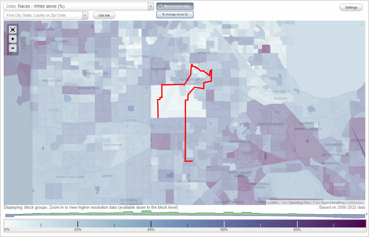
Area: 4.814 square miles
Population: 35,644
Population density:
| The Strip (The Las Vegas Strip): | 7,405 people per square mile |
| Las Vegas: | 5,792 people per square mile |

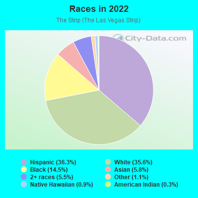
- 13,19336.3%Hispanic or Latino
- 12,96135.6%White
- 5,28214.5%Black
- 2,1185.8%Asian
- 1,9985.5%Two or more races
- 4161.1%Some other race
- 3140.9%Native Hawaiian and Other
Pacific Islander - 1100.3%American Indian
Distribution of median household income
![Distribution of median household income]()
- 2,386Less than $10,000
- 6,807$10,000 to $19,999
- 3,277$20,000 to $29,999
- 1,017$30,000 to $39,999
- 1,421$40,000 to $49,999
- 771$50,000 to $59,999
- 990$60,000 to $74,999
- 1,527$75,000 to $99,999
- 1,740$100,000 to $124,999
- 735$125,000 to $149,999
- 814$150,000 to $199,999
- 1,629$200,000 or more

Distribution of owner-occupied house/condo value
![Distribution of owner-occupied house/condo value]()
- 623Less than $50,000
- 754$50,000 to $99,999
- 1,438$100,000 to $149,999
- 1,846$150,000 to $199,999
- 695$200,000 to $249,999
- 353$250,000 to $299,999
- 1,520$300,000 to $399,999
- 311$400,000 to $499,999
- 1,079$500,000 to $749,999
- 169$750,000 to $999,999
- 970$1,000,000 or more

Distribution of rent paid by renters
![Distribution of rent paid by renters]()
- 575Less than $100
- 4,832$100 to $199
- 1,038$200 to $299
- 1,403$300 to $399
- 860$400 to $499
- 1,548$500 to $599
- 2,800$600 to $699
- 2,422$700 to $799
- 2,318$800 to $899
- 1,658$900 to $999
- 1,424$1,000 to $1,249
- 1,981$1,250 to $1,499
- 1,518$1,500 to $1,999
- 3,135$2,000 or more

Median rent in 2022:
| The Strip (The Las Vegas Strip): | $838 |
| Las Vegas: | $1,277 |
| Males: | 20,301 |
| Females: | 15,342 |
Males:
| This neighborhood: | 39.4 years |
| Whole city: | 38.4 years |
| This neighborhood: | 43.0 years |
| Whole city: | 38.9 years |
Average household size:
| The Strip (The Las Vegas Strip): | 2.1 people |
| Las Vegas: | 2.7 people |
Percentage of family households:
| The Strip (The Las Vegas Strip): | 22.9% |
| Las Vegas: | 45.8% |
| Here: | 20.1% |
| Las Vegas: | 40.9% |
Percentage of married-couple families with children (among all households):
| The Strip (The Las Vegas Strip): | 25.5% |
| Las Vegas: | 23.4% |
Percentage of single-mother households (among all households):
| The Strip (The Las Vegas Strip): | 24.8% |
| Las Vegas: | 10.1% |
Percentage of never married males 15 years old and over:
Percentage of never married females 15 years old and over:
| The Strip (The Las Vegas Strip): | 27.4% |
| Las Vegas: | 19.7% |
Percentage of never married females 15 years old and over:
| The Strip (The Las Vegas Strip): | 19.7% |
| city: | 17.0% |
Percentage of people that speak English not well or not at all:
| The Strip (The Las Vegas Strip): | 13.9% |
| Las Vegas: | 7.0% |
Percentage of people born in this state:
Percentage of people born in another U.S. state:
Percentage of native residents but born outside the U.S.:
Percentage of foreign born residents:
| Here: | 16.0% |
| Las Vegas: | 27.3% |
Percentage of people born in another U.S. state:
| The Strip (The Las Vegas Strip): | 50.8% |
| Las Vegas: | 49.8% |
Percentage of native residents but born outside the U.S.:
| Here: | 3.2% |
| city: | 1.9% |
Percentage of foreign born residents:
| Here: | 30.4% |
| Las Vegas: | 21.0% |
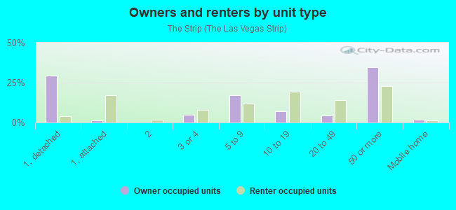
Owner-occupied
Renter-occupied

- Rooms in owner-occupied houses and condos in The Strip <
> - 1771 room
- 1,5662 rooms
- 1,6603 rooms
- 3404 rooms
- 4595 rooms
- 5916 rooms
- 5337 rooms
- 2918 rooms
- 2189+ rooms
- Rooms in renter-occupied apartments in The Strip <
> - 2,2481 room
- 4,8712 rooms
- 3,9843 rooms
- 4,1084 rooms
- 1,8135 rooms
- 2626 rooms
- 4027 rooms
- 5928 rooms
- 3299+ rooms
Owner-occupied
Renter-occupied
- Bedrooms in owner-occupied houses and condos in The Strip <
> - 117no bedroom
- 1,0771 bedroom
- 2,0462 bedrooms
- 8373 bedrooms
- 7884 bedrooms
- 1965+ bedrooms
- Bedrooms in renter-occupied apartments in The Strip <
> - 2,800no bedroom
- 8,8561 bedroom
- 4,5642 bedrooms
- 7173 bedrooms
- 4494 bedrooms
- 3295+ bedrooms
Average number of cars or other vehicles available in houses/condos:
Average number of cars or other vehicles available in apartments:
| This neighborhood: | |
| Las Vegas: |
Average number of cars or other vehicles available in apartments:
| Here: | 0.7 |
| city: | 1.3 |
Percentage of units with a mortgage:
| The Strip (The Las Vegas Strip): | 70.0% |
| Las Vegas: | 69.3% |
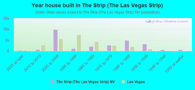
- Year house built in The Strip <
> - 4352020 or later
- 8402010 to 2019
- 9,8542000 to 2009
- 1,2921990 to 1999
- 2,2151980 to 1989
- 2,6991970 to 1979
- 4,9621960 to 1969
- 3,3441950 to 1959
- 7391940 to 1949
- 6751939 or earlier
City-data.com crime index for city in 2020 (higher means more crime):
| City: | 280.7 |
| U.S. average: | 219.5 |
Travel time to work (commute)
![Travel time to work (commute)]()
- 275Less than 5 minutes
- 1,0905 to 9 minutes
- 1,21710 to 14 minutes
- 1,45015 to 19 minutes
- 2,37220 to 24 minutes
- 36625 to 29 minutes
- 62530 to 34 minutes
- 30335 to 39 minutes
- 17440 to 44 minutes
- 53845 to 59 minutes
- 17360 to 89 minutes
- 22990 or more minutes

Means of transportation to work
![Means of transportation to work]()
- 58.7%8,115Drove a car alone
- 13.9%1,921Carpooled
- 10.3%1,421Bus
- 1.6%217Subway or elevated rail
- 0.5%69Long-distance train or commuter rail
- 2.1%294Taxi
- 2.9%396Motorcycle
- 2.2%302Bicycle
- 6.9%956Walked
- 7.0%965Other means
- 11.2%1,544Worked at home

Time leaving home to go to work
![Time leaving home to go to work]()
- 86112:00 a.m. to 4:59 a.m.
- 2875:00 a.m. to 5:29 a.m.
- 2535:30 a.m. to 5:59 a.m.
- 4126:00 a.m. to 6:29 a.m.
- 1986:30 a.m. to 6:59 a.m.
- 8847:00 a.m. to 7:29 a.m.
- 7207:30 a.m. to 7:59 a.m.
- 9078:00 a.m. to 8:29 a.m.
- 8538:30 a.m. to 8:59 a.m.
- 5149:00 a.m. to 9:59 a.m.
- 38910:00 a.m. to 10:59 a.m.
- 7511:00 a.m. to 11:59 a.m.
- 1,26212:00 p.m. to 3:59 p.m.
- 1,2004:00 p.m. to 11:59 p.m.

Occupations of males:
- Percentage of males in management occupations (except farmers):
Here: 13.6% city: 9.6%
- Percentage of males in business and financial operations occupations:
Here: 3.2% city: 3.6%
- Percentage of males in architecture and engineering occupations:
Here: 3.5% city: 1.8%
- Percentage of males in arts, design, entertainment, sports, and media occupations:
Here: 2.2% city: 2.5%
- Percentage of males in healthcare practitioners and technical occupations:
Here: 1.7% city: 3.3%
- Percentage of males in service occupations:
Here: 16.1% city: 23.3%
- Percentage of males in sales and office occupations:
Here: 27.5% city: 16.6%
- Percentage of males in farming, fishing, and forestry occupations:
Here: 1.9% city: 0.3%
- Percentage of males in construction, extraction, and maintenance occupations:
Here: 3.8% city: 10.6%
- Percentage of males in production occupations:
Here: 1.6% city: 3.3%
- Percentage of males in transportation occupations:
Here: 10.0% city: 6.6%
- Percentage of males in material moving occupations:
Here: 4.8% city: 5.4%
Occupations of females:
- Percentage of females in management occupations (except farmers):
Here: 11.0% city: 8.5%
- Percentage of females in business and financial operations occupations:
Here: 2.1% city: 5.7%
- Percentage of females in life, physical, and social science occupations:
Here: 4.4% city: 0.4%
- Percentage of females in education, training, and library occupations:
Here: 9.2% city: 8.0%
- Percentage of females in arts, design, entertainment, sports, and media occupations:
Here: 2.9% city: 1.8%
- Percentage of females in healthcare practitioners and technical occupations:
Here: 6.3% city: 7.4%
- Percentage of females in service occupations:
Here: 34.7% city: 26.5%
- Percentage of females in sales and office occupations:
Here: 17.0% city: 30.5%
- Percentage of females in production occupations:
Here: 2.4% city: 1.8%
- Percentage of females in transportation occupations:
Here: 4.4% city: 1.6%
- Percentage of females in material moving occupations:
Here: 4.4% city: 2.2%
Percentage of people 16-64 in Armed Forces:
| The Strip (The Las Vegas Strip): | 0.0% |
| Las Vegas: | 1.0% |
Education in this neighborhood (subdivision or community):
- Percentage of people 3 years and older in K-12 schools:
The Strip (The Las Vegas Strip): 12.5% Las Vegas: 17.4%
- Percentage of people 3 years and older in undergraduate colleges:
The Strip (The Las Vegas Strip): 6.2% Las Vegas: 4.2%
- Percentage of people 3 years and older in grad. or professional schools:
The Strip (The Las Vegas Strip): 1.5% Las Vegas: 1.0%
- Percentage of students K-12 enrolled in private schools:
The Strip (The Las Vegas Strip): 14.3% Las Vegas: 12.9%
Percentage of population below poverty level:
| The Strip (The Las Vegas Strip): | 27.5% |
| Las Vegas: | 14.1% |
Median year renter moved in (as recorded in 2022):
| The Strip (The Las Vegas Strip): | 2018 |
| Las Vegas: | 2020 |
Percentage of married-couple families with both working:
| The Strip (The Las Vegas Strip): | 53.4% |
| Las Vegas: | 62.0% |
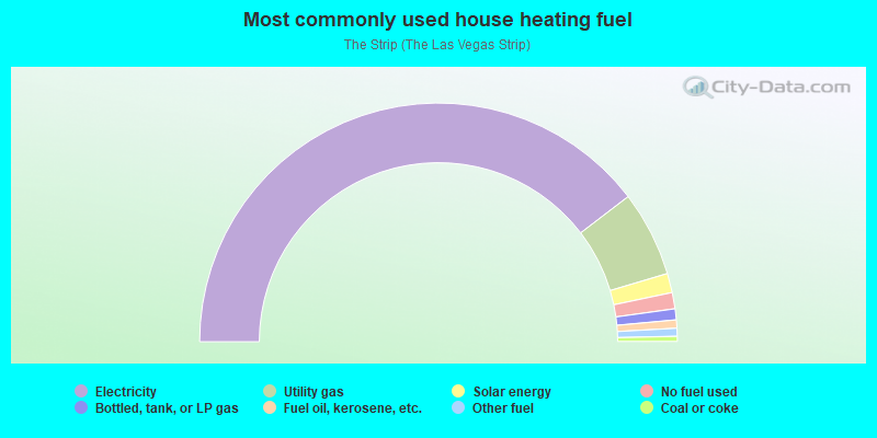
- 79.3%Electricity
- 11.6%Utility gas
- 2.6%Solar energy
- 2.2%No fuel used
- 1.5%Bottled, tank, or LP gas
- 1.1%Fuel oil, kerosene, etc.
- 1.1%Other fuel
- 0.7%Coal or coke
Limited-access highways (interstate or state) in this neighborhood:
Las Vegas Fwy (I- 15)
Length: 3.71 miles
Direction: N-S
Address range: 4300 to 5936
Direction: N-S
Address range: 4300 to 5936
E Desert Inn Rd
Length: 1.47 miles
Directions: E-W, SE-NW
Address range: 2 to 398
Directions: E-W, SE-NW
Address range: 2 to 398
Wilber Clark Di West Rd
Length: 0.59 miles
Direction: E-W
Direction: E-W
Wilber Clark Di East Rd
Length: 0.59 miles
Directions: E-W, SE-NW
Directions: E-W, SE-NW
Highways in this neighborhood:
Las Vegas Blvd S (State Rte 604)
Length: 6.00 miles
Directions: N-S, SW-NE
Address range: 1600 to 6399
Directions: N-S, SW-NE
Address range: 1600 to 6399
Roads and streets:
Frank Sinatra Dr
Length: 2.79 miles
Directions: E-W, N-S, SE-NW, SW-NE
Directions: E-W, N-S, SE-NW, SW-NE
Industrial Rd
Length: 2.64 miles
Direction: SW-NE
Address range: 1604 to 3695
Direction: SW-NE
Address range: 1604 to 3695
Koval Ln
Length: 1.74 miles
Directions: N-S, SW-NE
Address range: 3700 to 5199
Directions: N-S, SW-NE
Address range: 3700 to 5199
Paradise Rd
Length: 1.29 miles
Direction: N-S
Address range: 2500 to 3599
Direction: N-S
Address range: 2500 to 3599
E Reno Ave
Length: 1.10 miles
Directions: E-W, SE-NW, SW-NE
Address range: 1 to 199
Directions: E-W, SE-NW, SW-NE
Address range: 1 to 199
Country Club Ln
Length: 1.09 miles
Directions: E-W, N-S, SW-NE
Address range: 1 to 99
Directions: E-W, N-S, SW-NE
Address range: 1 to 99
Sands Ave
Length: 0.80 miles
Directions: E-W, SE-NW
Address range: 1 to 299
Directions: E-W, SE-NW
Address range: 1 to 299
Convention Center Dr
Length: 0.77 miles
Directions: E-W, SE-NW
Address range: 1 to 425
Directions: E-W, SE-NW
Address range: 1 to 425
Spring Mountain Rd (W Spring Mountain Rd)
Length: 0.69 miles
Directions: E-W, SE-NW
Address range: 1 to 1998
Directions: E-W, SE-NW
Address range: 1 to 1998
Fairfield Ave
Length: 0.63 miles
Directions: E-W, N-S, SE-NW, SW-NE
Address range: 1600 to 2599
Directions: E-W, N-S, SE-NW, SW-NE
Address range: 1600 to 2599
E Tropicana Ave
Length: 0.63 miles
Direction: E-W
Address range: 1 to 199
Direction: E-W
Address range: 1 to 199
W Sahara Ave
Length: 0.63 miles
Direction: E-W
Address range: 1 to 1399
Direction: E-W
Address range: 1 to 1399
E Harmon Ave
Length: 0.62 miles
Direction: E-W
Address range: 1 to 199
Direction: E-W
Address range: 1 to 199
(Ave of the Hiltons)
Length: 0.62 miles
Directions: E-W, N-S, SE-NW, SW-NE
Address range: 3000 to 3099
Directions: E-W, N-S, SE-NW, SW-NE
Address range: 3000 to 3099
E Flamingo Rd
Length: 0.61 miles
Direction: E-W
Address range: 1 to 199
Direction: E-W
Address range: 1 to 199
Dio Dr
Length: 0.60 miles
Directions: E-W, SE-NW
Address range: 33 to 199
Directions: E-W, SE-NW
Address range: 33 to 199
Audrie St
Length: 0.58 miles
Directions: N-S, SW-NE
Address range: 3900 to 4110
Directions: N-S, SW-NE
Address range: 3900 to 4110
W Harmon Ave
Length: 0.54 miles
Directions: E-W, SE-NW, SW-NE
Directions: E-W, SE-NW, SW-NE
Fashion Show
Length: 0.53 miles
Directions: E-W, N-S, SE-NW
Directions: E-W, N-S, SE-NW
Dunes Rd (W Flamingo Rd)
Length: 0.53 miles
Direction: E-W
Address range: 1 to 1599
Direction: E-W
Address range: 1 to 1599
Hacienda
Length: 0.53 miles
Direction: E-W
Direction: E-W
Giles St
Length: 0.52 miles
Directions: N-S, SE-NW, SW-NE
Address range: 3800 to 3999
Directions: N-S, SE-NW, SW-NE
Address range: 3800 to 3999
W Tropicana Ave
Length: 0.52 miles
Direction: E-W
Address range: 3100 to 3129
Direction: E-W
Address range: 3100 to 3129
Stardust Rd
Length: 0.52 miles
Directions: E-W, SE-NW
Address range: 1 to 1598
Directions: E-W, SE-NW
Address range: 1 to 1598
Riviera Blvd
Length: 0.51 miles
Direction: E-W
Address range: 1 to 399
Direction: E-W
Address range: 1 to 399
Rue de Monte Carlo
Length: 0.49 miles
Direction: E-W
Direction: E-W
W Oquendo Rd
Length: 0.47 miles
Direction: E-W
Direction: E-W
Haven St
Length: 0.46 miles
Directions: E-W, N-S, SE-NW
Address range: 5400 to 5699
Directions: E-W, N-S, SE-NW
Address range: 5400 to 5699
W Wyoming Ave
Length: 0.45 miles
Direction: E-W
Address range: 1 to 399
Direction: E-W
Address range: 1 to 399
Circus Circus Dr
Length: 0.45 miles
Directions: E-W, SE-NW
Address range: 1 to 1099
Directions: E-W, SE-NW
Address range: 1 to 1099
W Russell Rd
Length: 0.44 miles
Direction: E-W
Direction: E-W
Tam Dr
Length: 0.42 miles
Directions: E-W, N-S, SE-NW, SW-NE
Address range: 2100 to 2499
Directions: E-W, N-S, SE-NW, SW-NE
Address range: 2100 to 2499
W Cincinnati Ave
Length: 0.41 miles
Directions: E-W, SE-NW
Address range: 100 to 399
Directions: E-W, SE-NW
Address range: 100 to 399
W Cleveland Ave
Length: 0.41 miles
Directions: E-W, SE-NW
Address range: 100 to 399
Directions: E-W, SE-NW
Address range: 100 to 399
W Baltimore Ave
Length: 0.41 miles
Directions: E-W, SE-NW
Address range: 100 to 399
Directions: E-W, SE-NW
Address range: 100 to 399
Fashion Show Dr
Length: 0.40 miles
Directions: E-W, N-S, SE-NW
Directions: E-W, N-S, SE-NW
S Bridge Ln
Length: 0.36 miles
Directions: E-W, SW-NE
Address range: 400 to 499
Directions: E-W, SW-NE
Address range: 400 to 499
W Chicago Ave
Length: 0.35 miles
Direction: E-W
Address range: 100 to 399
Direction: E-W
Address range: 100 to 399
Green Lawn Ln
Length: 0.34 miles
Directions: E-W, N-S, SW-NE
Address range: 1 to 99
Directions: E-W, N-S, SW-NE
Address range: 1 to 99
E Sahara Ave
Length: 0.33 miles
Direction: E-W
Address range: 1 to 399
Direction: E-W
Address range: 1 to 399
E Hacienda Ave
Length: 0.33 miles
Directions: E-W, SE-NW, SW-NE
Address range: 1 to 93
Directions: E-W, SE-NW, SW-NE
Address range: 1 to 93
W New York Ave
Length: 0.32 miles
Direction: E-W
Address range: 100 to 299
Direction: E-W
Address range: 100 to 299
E Diablo Ave
Length: 0.32 miles
Direction: E-W
Address range: 1 to 109
Direction: E-W
Address range: 1 to 109
W Sunset Rd
Length: 0.31 miles
Direction: E-W
Address range: 1000 to 2599
Direction: E-W
Address range: 1000 to 2599
Winnick Ave
Length: 0.31 miles
Directions: E-W, SE-NW
Address range: 1 to 199
Directions: E-W, SE-NW
Address range: 1 to 199
Burbank Ave
Length: 0.30 miles
Directions: E-W, N-S, SE-NW, SW-NE
Address range: 3200 to 3699
Directions: E-W, N-S, SE-NW, SW-NE
Address range: 3200 to 3699
W Philadelphia Ave
Length: 0.30 miles
Direction: E-W
Address range: 100 to 299
Direction: E-W
Address range: 100 to 299
Emerson Ave
Length: 0.29 miles
Directions: E-W, SE-NW
Address range: 1 to 199
Directions: E-W, SE-NW
Address range: 1 to 199
W Post Rd
Length: 0.28 miles
Directions: E-W, N-S, SW-NE
Address range: 1284 to 2999
Directions: E-W, N-S, SW-NE
Address range: 1284 to 2999
Buccaneer Blvd
Length: 0.27 miles
Directions: E-W, N-S, SE-NW, SW-NE
Directions: E-W, N-S, SE-NW, SW-NE
S Main St
Length: 0.27 miles
Direction: N-S
Address range: 1600 to 1999
Direction: N-S
Address range: 1600 to 1999
Albert Ave
Length: 0.27 miles
Direction: E-W
Address range: 100 to 199
Direction: E-W
Address range: 100 to 199
Ida Ave
Length: 0.27 miles
Directions: E-W, SW-NE
Address range: 100 to 199
Directions: E-W, SW-NE
Address range: 100 to 199
Windy Rd (Windy St)
Length: 0.26 miles
Direction: N-S
Address range: 6100 to 6499
Direction: N-S
Address range: 6100 to 6499
W Saint Louis Ave
Length: 0.26 miles
Directions: E-W, SE-NW
Address range: 200 to 399
Directions: E-W, SE-NW
Address range: 200 to 399
W Boston Ave
Length: 0.25 miles
Directions: E-W, SE-NW
Address range: 200 to 399
Directions: E-W, SE-NW
Address range: 200 to 399
Duke Ellington Way
Length: 0.25 miles
Direction: N-S
Address range: 4900 to 5199
Direction: N-S
Address range: 4900 to 5199
Vegas Plaza Dr
Length: 0.25 miles
Directions: E-W, N-S, SE-NW
Address range: 3500 to 3699
Directions: E-W, N-S, SE-NW
Address range: 3500 to 3699
Olympic Blvd
Length: 0.25 miles
Direction: SW-NE
Direction: SW-NE
Ensworth St
Length: 0.24 miles
Directions: N-S, SE-NW
Address range: 6100 to 6499
Directions: N-S, SE-NW
Address range: 6100 to 6499
E Lexington St
Length: 0.23 miles
Direction: N-S
Direction: N-S
E Oakey Blvd
Length: 0.22 miles
Direction: E-W
Address range: 1 to 531
Direction: E-W
Address range: 1 to 531
W Teco Ave
Length: 0.22 miles
Direction: E-W
Address range: 2600 to 2999
Direction: E-W
Address range: 2600 to 2999
S Commerce St
Length: 0.22 miles
Direction: N-S
Address range: 1600 to 1899
Direction: N-S
Address range: 1600 to 1899
Karen Ave
Length: 0.20 miles
Direction: E-W
Address range: 200 to 499
Direction: E-W
Address range: 200 to 499
Channel 8 Dr
Length: 0.18 miles
Direction: N-S
Address range: 3200 to 3299
Direction: N-S
Address range: 3200 to 3299
Bellagio Dr
Length: 0.18 miles
Directions: E-W, SE-NW, SW-NE
Directions: E-W, SE-NW, SW-NE
Debbie Reynolds Dr (Mel Ave)
Length: 0.18 miles
Direction: N-S
Address range: 3100 to 3299
Direction: N-S
Address range: 3100 to 3299
Holmes St
Length: 0.17 miles
Directions: N-S, SW-NE
Address range: 3200 to 3299
Directions: N-S, SW-NE
Address range: 3200 to 3299
E Dewey Dr
Length: 0.16 miles
Direction: E-W
Address range: 1 to 69
Direction: E-W
Address range: 1 to 69
Black Canyon Ave
Length: 0.16 miles
Directions: E-W, SE-NW
Address range: 2200 to 2499
Directions: E-W, SE-NW
Address range: 2200 to 2499
Kishner Dr
Length: 0.16 miles
Directions: N-S, SW-NE
Address range: 3000 to 3199
Directions: N-S, SW-NE
Address range: 3000 to 3199
E Wyoming Ave
Length: 0.15 miles
Direction: E-W
Address range: 1 to 299
Direction: E-W
Address range: 1 to 299
Nile Ct
Length: 0.14 miles
Directions: E-W, N-S, SE-NW, SW-NE
Directions: E-W, N-S, SE-NW, SW-NE
Columbia Dr
Length: 0.13 miles
Directions: E-W, N-S, SE-NW
Directions: E-W, N-S, SE-NW
Pershing Ave (Pershing Ave E)
Length: 0.13 miles
Direction: E-W
Address range: 2200 to 2499
Direction: E-W
Address range: 2200 to 2499
Danville Ln
Length: 0.13 miles
Direction: N-S
Address range: 5300 to 5499
Direction: N-S
Address range: 5300 to 5499
Bethel Ln
Length: 0.12 miles
Direction: N-S
Address range: 5300 to 5399
Direction: N-S
Address range: 5300 to 5399
W Oakey Blvd
Length: 0.10 miles
Direction: E-W
Address range: 1 to 199
Direction: E-W
Address range: 1 to 199
Northbridge St
Length: 0.09 miles
Directions: E-W, SE-NW
Address range: 300 to 499
Directions: E-W, SE-NW
Address range: 300 to 499
Terry Dr
Length: 0.09 miles
Direction: E-W
Direction: E-W
W Russell
Length: 0.09 miles
Direction: E-W
Address range: 2900 to 3049
Direction: E-W
Address range: 2900 to 3049
Western Ave
Length: 0.08 miles
Direction: SW-NE
Address range: 1600 to 1831
Direction: SW-NE
Address range: 1600 to 1831
Cathedral Way
Length: 0.08 miles
Directions: E-W, SE-NW, SW-NE
Address range: 1 to 399
Directions: E-W, SE-NW, SW-NE
Address range: 1 to 399
E Ali Baba Ln (Ali Baba Ln)
Length: 0.08 miles
Direction: E-W
Address range: 1 to 99
Direction: E-W
Address range: 1 to 99
Lyon Dr
Length: 0.08 miles
Direction: N-S
Address range: 3500 to 3699
Direction: N-S
Address range: 3500 to 3699
W Desert Inn Rd
Length: 0.07 miles
Directions: E-W, SE-NW
Directions: E-W, SE-NW
Artic Cir
Length: 0.07 miles
Directions: E-W, N-S, SE-NW, SW-NE
Directions: E-W, N-S, SE-NW, SW-NE
London Dr
Length: 0.06 miles
Directions: E-W, SE-NW
Directions: E-W, SE-NW
S Casino Center Blvd
Length: 0.06 miles
Direction: N-S
Address range: 1600 to 1699
Direction: N-S
Address range: 1600 to 1699
Fashion la
Length: 0.06 miles
Directions: E-W, N-S, SE-NW
Directions: E-W, N-S, SE-NW
Sadie
Length: 0.06 miles
Direction: N-S
Address range: 3000 to 3099
Direction: N-S
Address range: 3000 to 3099
Via del Nord
Length: 0.05 miles
Directions: E-W, N-S, SE-NW
Directions: E-W, N-S, SE-NW
Herbin Ln
Length: 0.05 miles
Direction: SW-NE
Direction: SW-NE
Island Way
Length: 0.05 miles
Direction: N-S
Direction: N-S
Paris Ave
Length: 0.04 miles
Directions: E-W, SE-NW
Directions: E-W, SE-NW
Peru Ln
Length: 0.04 miles
Direction: E-W
Direction: E-W
W Twain Ave
Length: 0.04 miles
Direction: E-W
Direction: E-W
E Mesa Vis
Length: 0.03 miles
Direction: E-W
Address range: 1 to 99
Direction: E-W
Address range: 1 to 99
Railroad features:
Union Pacific RR
Length: 3.04 miles
Directions: E-W, SW-NE
Directions: E-W, SW-NE
Up RR Hend Spur
Length: 0.40 miles
Directions: E-W, SE-NW
Directions: E-W, SE-NW
Up RR
Length: 0.03 miles
Direction: SW-NE
Direction: SW-NE
Other features:
Trop Wash
Length: 1.14 miles
Directions: E-W, N-S, SW-NE
Directions: E-W, N-S, SW-NE