Stapleton neighborhood in Staten Island, New York (NY), 10304, 10301, 10310 detailed profile
Settings
X


Business Search - 14 Million verified businesses
Area: 2.171 square miles
Population: 37,158
Population density:
| Stapleton: | 17,114 people per square mile |
| Staten Island: | 7,588 people per square mile |

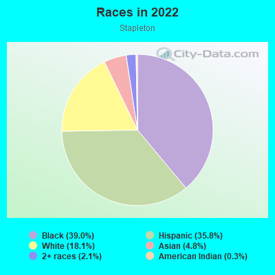
- 14,63439.0%Black
- 13,41735.8%Hispanic or Latino
- 6,77418.1%White
- 1,7924.8%Asian
- 7782.1%Two or more races
- 1080.3%American Indian
Distribution of median household income
![Distribution of median household income]()
- 2,688Less than $10,000
- 4,340$10,000 to $19,999
- 1,621$20,000 to $29,999
- 1,407$30,000 to $39,999
- 3,787$40,000 to $49,999
- 926$50,000 to $59,999
- 1,692$60,000 to $74,999
- 2,174$75,000 to $99,999
- 619$100,000 to $124,999
- 1,197$125,000 to $149,999
- 957$150,000 to $199,999
- 947$200,000 or more

Distribution of owner-occupied house/condo value
![Distribution of owner-occupied house/condo value]()
- 1,929Less than $50,000
- 1,909$50,000 to $99,999
- 360$100,000 to $149,999
- 111$150,000 to $199,999
- 240$200,000 to $249,999
- 673$250,000 to $299,999
- 379$300,000 to $399,999
- 944$400,000 to $499,999
- 1,709$500,000 to $749,999
- 440$750,000 to $999,999
- 996$1,000,000 or more

Distribution of rent paid by renters
![Distribution of rent paid by renters]()
- 566Less than $100
- 4,171$100 to $199
- 5,979$200 to $299
- 1,668$300 to $399
- 2,348$400 to $499
- 678$500 to $599
- 2,019$600 to $699
- 767$700 to $799
- 544$800 to $899
- 441$900 to $999
- 1,233$1,000 to $1,249
- 1,796$1,250 to $1,499
- 2,471$1,500 to $1,999
- 3,083$2,000 or more

| Males: | 17,251 |
| Females: | 19,906 |
| Males: | 38.4 years |
| Females: | 41.1 years |
Average household size:
| Stapleton: | 2.7 people |
| New York: | 2.5 people |
Percentage of family households:
| Stapleton: | 48.0% |
| New York: | 41.3% |
| Here: | 24.7% |
| New York: | 42.3% |
Percentage of married-couple families with children (among all households):
| Stapleton: | 11.2% |
| New York: | 57.0% |
Percentage of single-mother households (among all households):
| Stapleton: | 32.3% |
| New York: | 9.3% |
Percentage of never married males 15 years old and over:
Percentage of never married females 15 years old and over:
| Stapleton: | 26.0% |
| New York: | 19.8% |
Percentage of never married females 15 years old and over:
| Stapleton: | 25.5% |
| New York: | 18.9% |
Percentage of people that speak English not well or not at all:
| Stapleton: | 6.7% |
| New York: | 6.8% |
Percentage of people born in this state:
Percentage of people born in another U.S. state:
Percentage of native residents but born outside the U.S.:
Percentage of foreign born residents:
| Here: | 60.8% |
| New York: | 62.5% |
Percentage of people born in another U.S. state:
| Stapleton: | 8.9% |
| New York: | 12.2% |
Percentage of native residents but born outside the U.S.:
| Here: | 3.9% |
| New York: | 2.6% |
Percentage of foreign born residents:
| Here: | 26.5% |
| New York: | 22.7% |
Owner-occupied
Renter-occupied

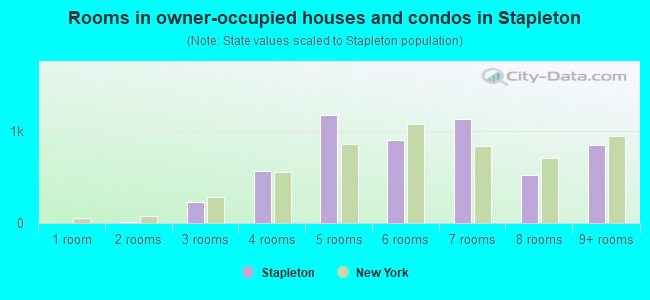
- Rooms in owner-occupied houses and condos in Stapleton
- 01 room
- 132 rooms
- 2293 rooms
- 5644 rooms
- 1,1755 rooms
- 9046 rooms
- 1,1337 rooms
- 5238 rooms
- 8489+ rooms
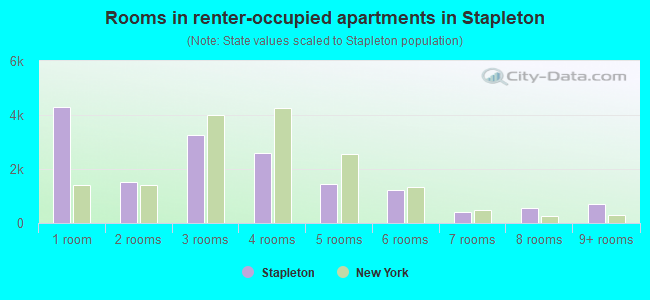
- Rooms in renter-occupied apartments in Stapleton
- 4,3001 room
- 1,5232 rooms
- 3,2663 rooms
- 2,6044 rooms
- 1,4325 rooms
- 1,2336 rooms
- 3907 rooms
- 5558 rooms
- 6869+ rooms
Owner-occupied
Renter-occupied
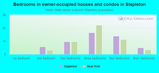
- Bedrooms in owner-occupied houses and condos in Stapleton
- 0no bedroom
- 5671 bedroom
- 9582 bedrooms
- 1,6423 bedrooms
- 1,3934 bedrooms
- 4955+ bedrooms
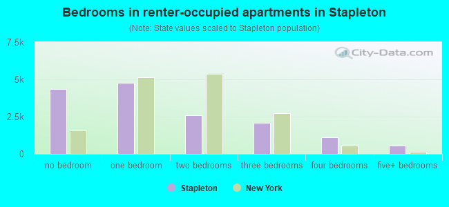
- Bedrooms in renter-occupied apartments in Stapleton
- 4,337no bedroom
- 4,7591 bedroom
- 2,6132 bedrooms
- 2,0863 bedrooms
- 1,1334 bedrooms
- 5445+ bedrooms
Average number of cars or other vehicles available in houses/condos:
Average number of cars or other vehicles available in apartments:
| This neighborhood: | |
| New York: |
Average number of cars or other vehicles available in apartments:
| Here: | 0.7 |
| New York: | 0.7 |
Percentage of units with a mortgage:
| Stapleton: | 52.5% |
| New York: | 58.3% |
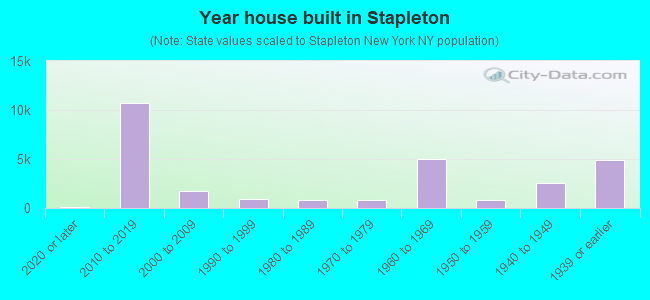
- Year house built in Stapleton
- 1152020 or later
- 10,7102010 to 2019
- 1,7522000 to 2009
- 9491990 to 1999
- 8041980 to 1989
- 7941970 to 1979
- 4,9501960 to 1969
- 8611950 to 1959
- 2,5871940 to 1949
- 4,9311939 or earlier
Travel time to work (commute)
![Travel time to work (commute)]()
- 408Less than 5 minutes
- 6225 to 9 minutes
- 96310 to 14 minutes
- 1,78715 to 19 minutes
- 1,24220 to 24 minutes
- 82425 to 29 minutes
- 1,56330 to 34 minutes
- 6235 to 39 minutes
- 32240 to 44 minutes
- 1,43745 to 59 minutes
- 3,05260 to 89 minutes
- 1,64590 or more minutes

Means of transportation to work
![Means of transportation to work]()
- 36.9%5,542Drove a car alone
- 7.3%1,096Carpooled
- 21.4%3,215Bus
- 9.7%1,450Subway or elevated rail
- 1.6%244Long-distance train or commuter rail
- 11.0%1,650Ferryboat
- 1.6%236Bicycle
- 8.0%1,199Walked
- 13.0%1,950Other means
- 6.3%950Worked at home

Time leaving home to go to work
![Time leaving home to go to work]()
- 16912:00 a.m. to 4:59 a.m.
- 7395:00 a.m. to 5:29 a.m.
- 2425:30 a.m. to 5:59 a.m.
- 1,5216:00 a.m. to 6:29 a.m.
- 1,4966:30 a.m. to 6:59 a.m.
- 1,8067:00 a.m. to 7:29 a.m.
- 2,0307:30 a.m. to 7:59 a.m.
- 1,1468:00 a.m. to 8:29 a.m.
- 9778:30 a.m. to 8:59 a.m.
- 9479:00 a.m. to 9:59 a.m.
- 71110:00 a.m. to 10:59 a.m.
- 61011:00 a.m. to 11:59 a.m.
- 1,52812:00 p.m. to 3:59 p.m.
- 9584:00 p.m. to 11:59 p.m.

Occupations of males:
- Percentage of males in management occupations (except farmers):
Here: 8.6% New York: 11.9%
- Percentage of males in business and financial operations occupations:
Here: 2.8% New York: 5.8%
- Percentage of males in architecture and engineering occupations:
Here: 5.1% New York: 2.6%
- Percentage of males in community and social services occupations:
Here: 2.7% New York: 1.3%
- Percentage of males in education, training, and library occupations:
Here: 1.2% New York: 4.2%
- Percentage of males in arts, design, entertainment, sports, and media occupations:
Here: 2.6% New York: 3.2%
- Percentage of males in service occupations:
Here: 32.8% New York: 16.9%
- Percentage of males in sales and office occupations:
Here: 14.7% New York: 15.2%
- Percentage of males in farming, fishing, and forestry occupations:
Here: 1.6% New York: 0.3%
- Percentage of males in construction, extraction, and maintenance occupations:
Here: 13.1% New York: 8.2%
- Percentage of males in production occupations:
Here: 2.6% New York: 4.6%
- Percentage of males in transportation occupations:
Here: 7.7% New York: 6.7%
- Percentage of males in material moving occupations:
Here: 3.5% New York: 3.7%
Occupations of females:
- Percentage of females in management occupations (except farmers):
Here: 2.7% New York: 9.8%
- Percentage of females in business and financial operations occupations:
Here: 3.8% New York: 6.5%
- Percentage of females in computer and mathematical occupations:
Here: 4.2% New York: 1.6%
- Percentage of females in community and social services occupations:
Here: 3.8% New York: 3.1%
- Percentage of females in education, training, and library occupations:
Here: 7.0% New York: 11.3%
- Percentage of females in arts, design, entertainment, sports, and media occupations:
Here: 2.9% New York: 3.4%
- Percentage of females in healthcare practitioners and technical occupations:
Here: 5.9% New York: 9.7%
- Percentage of females in service occupations:
Here: 40.5% New York: 21.4%
- Percentage of females in sales and office occupations:
Here: 26.1% New York: 24.9%
Percentage of people 16-64 in Armed Forces:
| Stapleton: | 1.2% |
| New York: | 0.2% |
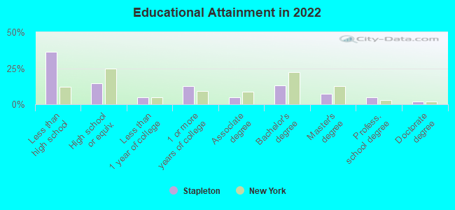
Education in this neighborhood (subdivision or community):
- Percentage of people 3 years and older in K-12 schools:
Stapleton: 22.4% New York: 15.4%
- Percentage of people 3 years and older in undergraduate colleges:
Stapleton: 10.1% New York: 5.3%
- Percentage of people 3 years and older in grad. or professional schools:
Stapleton: 2.6% New York: 1.8%
- Percentage of students K-12 enrolled in private schools:
Stapleton: 33.7% New York: 15.5%
Percentage of population below poverty level:
| Stapleton: | 33.2% |
| New York: | 14.3% |
Percentage of married-couple families with both working:
| Stapleton: | 94.3% |
| New York: | 72.1% |
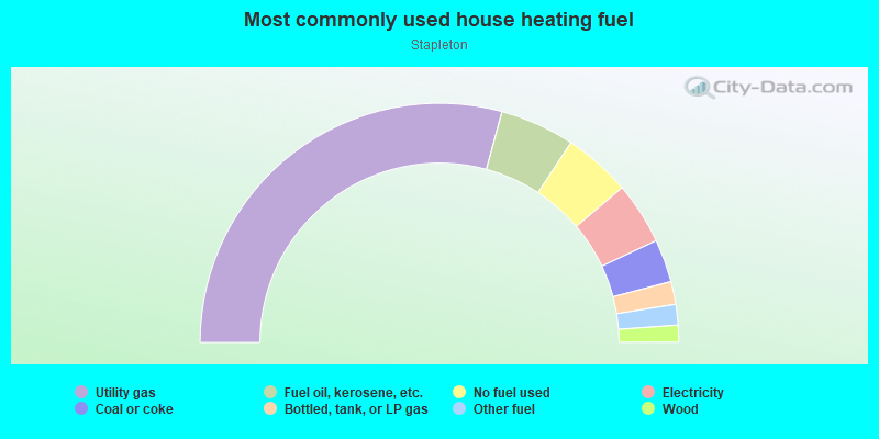
- 58.5%Utility gas
- 10.1%Fuel oil, kerosene, etc.
- 9.1%No fuel used
- 8.4%Electricity
- 5.8%Coal or coke
- 3.1%Bottled, tank, or LP gas
- 2.8%Other fuel
- 2.3%Wood
Roads and streets:
Richmond Ter
Length: 3.64 miles
Directions: E-W, SE-NW, SW-NE
Address range: 170 to 1899
Directions: E-W, SE-NW, SW-NE
Address range: 170 to 1899
Vanderbilt Ave
Length: 1.17 miles
Direction: SW-NE
Address range: 1 to 542
Direction: SW-NE
Address range: 1 to 542
Bay St
Length: 1.15 miles
Directions: N-S, SE-NW, SW-NE
Address range: 181 to 822
Directions: N-S, SE-NW, SW-NE
Address range: 181 to 822
Targee St
Length: 0.77 miles
Direction: N-S
Address range: 41 to 499
Direction: N-S
Address range: 41 to 499
Broad St
Length: 0.63 miles
Direction: E-W
Address range: 1 to 282
Direction: E-W
Address range: 1 to 282
Gordon St
Length: 0.57 miles
Direction: N-S
Address range: 1 to 330
Direction: N-S
Address range: 1 to 330
Edgewater St
Length: 0.56 miles
Directions: E-W, SE-NW
Address range: 2 to 279
Directions: E-W, SE-NW
Address range: 2 to 279
Canal St
Length: 0.56 miles
Directions: E-W, SW-NE
Address range: 1 to 235
Directions: E-W, SW-NE
Address range: 1 to 235
Van Duzer St
Length: 0.55 miles
Directions: N-S, SE-NW, SW-NE
Address range: 100 to 378
Directions: N-S, SE-NW, SW-NE
Address range: 100 to 378
Front St
Length: 0.50 miles
Directions: E-W, N-S
Address range: 298 to 375
Directions: E-W, N-S
Address range: 298 to 375
Murray Hulbert Ave
Length: 0.49 miles
Direction: N-S
Address range: 1 to 28
Direction: N-S
Address range: 1 to 28
Tompkins Ave
Length: 0.36 miles
Direction: SE-NW
Address range: 1 to 189
Direction: SE-NW
Address range: 1 to 189
Beach St
Length: 0.34 miles
Direction: SE-NW
Address range: 1 to 150
Direction: SE-NW
Address range: 1 to 150
Prospect St
Length: 0.34 miles
Directions: E-W, SE-NW
Address range: 1 to 150
Directions: E-W, SE-NW
Address range: 1 to 150
Warren St
Length: 0.30 miles
Directions: N-S, SE-NW, SW-NE
Address range: 1 to 154
Directions: N-S, SE-NW, SW-NE
Address range: 1 to 154
Sands St
Length: 0.29 miles
Directions: E-W, SE-NW
Address range: 2 to 99
Directions: E-W, SE-NW
Address range: 2 to 99
Hannah St
Length: 0.29 miles
Directions: E-W, N-S, SE-NW, SW-NE
Address range: 1 to 58
Directions: E-W, N-S, SE-NW, SW-NE
Address range: 1 to 58
Boyd St
Length: 0.29 miles
Directions: E-W, SW-NE
Address range: 68 to 200
Directions: E-W, SW-NE
Address range: 68 to 200
Osgood Ave
Length: 0.28 miles
Directions: E-W, SE-NW
Address range: 32 to 145
Directions: E-W, SE-NW
Address range: 32 to 145
Hill St
Length: 0.26 miles
Direction: E-W
Address range: 1 to 99
Direction: E-W
Address range: 1 to 99
Tompkins St
Length: 0.25 miles
Direction: E-W
Address range: 1 to 109
Direction: E-W
Address range: 1 to 109
Harrison St
Length: 0.24 miles
Direction: E-W
Address range: 24 to 99
Direction: E-W
Address range: 24 to 99
Thompson St
Length: 0.24 miles
Direction: E-W
Address range: 1 to 99
Direction: E-W
Address range: 1 to 99
Wave St
Length: 0.24 miles
Direction: E-W
Address range: 1 to 99
Direction: E-W
Address range: 1 to 99
Victory Blvd
Length: 0.24 miles
Direction: E-W
Address range: 1 to 19
Direction: E-W
Address range: 1 to 19
Water St
Length: 0.24 miles
Direction: E-W
Address range: 1 to 80
Direction: E-W
Address range: 1 to 80
Laurel Ave
Length: 0.21 miles
Direction: E-W
Address range: 33 to 119
Direction: E-W
Address range: 33 to 119
Bay Street Lndg
Length: 0.21 miles
Directions: E-W, N-S
Address range: 1 to 999
Directions: E-W, N-S
Address range: 1 to 999
Coursen Pl
Length: 0.21 miles
Direction: SW-NE
Address range: 37 to 135
Direction: SW-NE
Address range: 37 to 135
Grant St
Length: 0.20 miles
Direction: E-W
Address range: 1 to 89
Direction: E-W
Address range: 1 to 89
Irving Pl
Length: 0.18 miles
Directions: E-W, SE-NW
Address range: 30 to 108
Directions: E-W, SE-NW
Address range: 30 to 108
Wright St
Length: 0.18 miles
Directions: N-S, SE-NW
Address range: 1 to 73
Directions: N-S, SE-NW
Address range: 1 to 73
Prince St
Length: 0.18 miles
Directions: E-W, SE-NW
Address range: 1 to 75
Directions: E-W, SE-NW
Address range: 1 to 75
Jackson St
Length: 0.18 miles
Direction: SW-NE
Address range: 1 to 98
Direction: SW-NE
Address range: 1 to 98
William St
Length: 0.17 miles
Direction: E-W
Address range: 1 to 79
Direction: E-W
Address range: 1 to 79
South St
Length: 0.17 miles
Direction: E-W
Direction: E-W
Roff St
Length: 0.16 miles
Direction: E-W
Address range: 28 to 108
Direction: E-W
Address range: 28 to 108
Brewster St
Length: 0.16 miles
Direction: SW-NE
Address range: 16 to 137
Direction: SW-NE
Address range: 16 to 137
Margo Loop
Length: 0.16 miles
Directions: E-W, N-S, SE-NW, SW-NE
Address range: 1 to 99
Directions: E-W, N-S, SE-NW, SW-NE
Address range: 1 to 99
Bank St
Length: 0.15 miles
Directions: E-W, SE-NW, SW-NE
Address range: 1 to 99
Directions: E-W, SE-NW, SW-NE
Address range: 1 to 99
Hardy St
Length: 0.15 miles
Direction: SW-NE
Address range: 1 to 62
Direction: SW-NE
Address range: 1 to 62
Clinton St
Length: 0.14 miles
Direction: E-W
Address range: 1 to 59
Direction: E-W
Address range: 1 to 59
Hudson St
Length: 0.14 miles
Direction: E-W
Address range: 1 to 58
Direction: E-W
Address range: 1 to 58
Tappen Ct
Length: 0.13 miles
Direction: SW-NE
Address range: 1 to 76
Direction: SW-NE
Address range: 1 to 76
Waverly Pl
Length: 0.12 miles
Directions: E-W, SE-NW
Address range: 36 to 149
Directions: E-W, SE-NW
Address range: 36 to 149
Minthorne St
Length: 0.12 miles
Directions: E-W, N-S
Address range: 2 to 44
Directions: E-W, N-S
Address range: 2 to 44
Cedar St
Length: 0.12 miles
Direction: SE-NW
Address range: 1 to 53
Direction: SE-NW
Address range: 1 to 53
Congress St
Length: 0.11 miles
Direction: E-W
Address range: 1 to 39
Direction: E-W
Address range: 1 to 39
Quinn St
Length: 0.11 miles
Direction: SE-NW
Address range: 1 to 99
Direction: SE-NW
Address range: 1 to 99
Grove St
Length: 0.10 miles
Directions: E-W, SW-NE
Address range: 1 to 36
Directions: E-W, SW-NE
Address range: 1 to 36
Pine Pl
Length: 0.10 miles
Direction: SE-NW
Address range: 137 to 199
Direction: SE-NW
Address range: 137 to 199
Brownell St
Length: 0.10 miles
Direction: SE-NW
Address range: 1 to 57
Direction: SE-NW
Address range: 1 to 57
Union Pl
Length: 0.08 miles
Direction: E-W
Address range: 1 to 14
Direction: E-W
Address range: 1 to 14
Fulton St
Length: 0.08 miles
Direction: N-S
Address range: 119 to 167
Direction: N-S
Address range: 119 to 167
Bodine St
Length: 0.08 miles
Direction: N-S
Direction: N-S
Baltic St
Length: 0.08 miles
Direction: E-W
Address range: 1 to 100
Direction: E-W
Address range: 1 to 100
Court St
Length: 0.08 miles
Direction: SE-NW
Address range: 1 to 27
Direction: SE-NW
Address range: 1 to 27
Hygeia Pl
Length: 0.08 miles
Direction: SE-NW
Address range: 1 to 38
Direction: SE-NW
Address range: 1 to 38
Cross St
Length: 0.08 miles
Direction: E-W
Address range: 1 to 24
Direction: E-W
Address range: 1 to 24
Gray St
Length: 0.07 miles
Direction: SE-NW
Address range: 1 to 30
Direction: SE-NW
Address range: 1 to 30
Wiederer Pl
Length: 0.07 miles
Direction: N-S
Address range: 2 to 99
Direction: N-S
Address range: 2 to 99
Susan Ct
Length: 0.07 miles
Direction: E-W
Address range: 1 to 45
Direction: E-W
Address range: 1 to 45
Van Duzer St Exn
Length: 0.07 miles
Direction: SW-NE
Direction: SW-NE
Thelma Ct
Length: 0.07 miles
Directions: E-W, SE-NW
Address range: 1 to 33
Directions: E-W, SE-NW
Address range: 1 to 33
St Julian Pl
Length: 0.07 miles
Direction: E-W
Address range: 5 to 20
Direction: E-W
Address range: 5 to 20
Swan St
Length: 0.07 miles
Direction: E-W
Address range: 2 to 44
Direction: E-W
Address range: 2 to 44
Frean St
Length: 0.07 miles
Direction: E-W
Address range: 1 to 28
Direction: E-W
Address range: 1 to 28
Purroy Pl
Length: 0.07 miles
Direction: E-W
Address range: 1 to 29
Direction: E-W
Address range: 1 to 29
Coursen Ct
Length: 0.06 miles
Direction: SE-NW
Address range: 1 to 22
Direction: SE-NW
Address range: 1 to 22
Dock St
Length: 0.06 miles
Directions: E-W, SW-NE
Address range: 21 to 29
Directions: E-W, SW-NE
Address range: 21 to 29
Pleasant Pl
Length: 0.06 miles
Direction: SE-NW
Address range: 1 to 29
Direction: SE-NW
Address range: 1 to 29
Tompkins Pl
Length: 0.05 miles
Direction: SW-NE
Address range: 1 to 31
Direction: SW-NE
Address range: 1 to 31
Delford St
Length: 0.05 miles
Direction: SW-NE
Address range: 1 to 30
Direction: SW-NE
Address range: 1 to 30
Garden St
Length: 0.05 miles
Direction: SW-NE
Address range: 31 to 50
Direction: SW-NE
Address range: 31 to 50
Metcalfe St
Length: 0.05 miles
Direction: E-W
Address range: 61 to 98
Direction: E-W
Address range: 61 to 98
Harbor Rd
Length: 0.05 miles
Direction: N-S
Direction: N-S
Dulancey Ct
Length: 0.05 miles
Directions: E-W, N-S
Address range: 15 to 39
Directions: E-W, N-S
Address range: 15 to 39
Adele Ct
Length: 0.05 miles
Direction: SW-NE
Address range: 2 to 26
Direction: SW-NE
Address range: 2 to 26
Broadway
Length: 0.05 miles
Direction: N-S
Address range: 1 to 39
Direction: N-S
Address range: 1 to 39
Pleasant Ct
Length: 0.04 miles
Direction: SE-NW
Address range: 1 to 23
Direction: SE-NW
Address range: 1 to 23
Dix Pl
Length: 0.04 miles
Direction: SE-NW
Address range: 1 to 22
Direction: SE-NW
Address range: 1 to 22
Mickardan Ct
Length: 0.04 miles
Directions: SE-NW, SW-NE
Address range: 10 to 16
Directions: SE-NW, SW-NE
Address range: 10 to 16
Jersey St
Length: 0.03 miles
Direction: SE-NW
Address range: 13 to 39
Direction: SE-NW
Address range: 13 to 39
Railroad features:
Abandoned RR
Length: 3.28 miles
Directions: E-W, N-S, SE-NW, SW-NE
Directions: E-W, N-S, SE-NW, SW-NE
Sirt
Length: 1.63 miles
Directions: N-S, SE-NW, SW-NE
Directions: N-S, SE-NW, SW-NE
Other features:
Bodine Crk
Length: 0.23 miles
Directions: N-S, SW-NE
Directions: N-S, SW-NE