South Union (Old Spanish Trail) neighborhood in Houston, Texas (TX), 77021 detailed profile
Settings
X


Business Search - 14 Million verified businesses
Area: 4.305 square miles
Population: 18,159
Population density:
| South Union (Old Spanish Trail): | 4,218 people per square mile |
| Houston: | 3,977 people per square mile |

- 12,29463.4%Black
- 4,65824.0%Hispanic or Latino
- 1,1666.0%White
- 5342.8%Two or more races
- 3862.0%Asian
- 2661.4%American Indian
- 780.4%Native Hawaiian and Other
Pacific Islander

Distribution of median household income
![Distribution of median household income]()
- 1,136Less than $10,000
- 1,291$10,000 to $19,999
- 1,377$20,000 to $29,999
- 824$30,000 to $39,999
- 1,005$40,000 to $49,999
- 468$50,000 to $59,999
- 1,069$60,000 to $74,999
- 579$75,000 to $99,999
- 612$100,000 to $124,999
- 338$125,000 to $149,999
- 530$150,000 to $199,999
- 447$200,000 or more

Distribution of owner-occupied house/condo value
![Distribution of owner-occupied house/condo value]()
- 3,692Less than $50,000
- 2,442$50,000 to $99,999
- 1,181$100,000 to $149,999
- 1,342$150,000 to $199,999
- 215$200,000 to $249,999
- 476$250,000 to $299,999
- 359$300,000 to $399,999
- 433$400,000 to $499,999
- 997$500,000 to $749,999
- 87$750,000 to $999,999
- 76$1,000,000 or more

Distribution of rent paid by renters
![Distribution of rent paid by renters]()
- 551Less than $100
- 493$100 to $199
- 402$200 to $299
- 649$300 to $399
- 783$400 to $499
- 783$500 to $599
- 1,133$600 to $699
- 1,248$700 to $799
- 529$800 to $899
- 652$900 to $999
- 867$1,000 to $1,249
- 588$1,250 to $1,499
- 630$1,500 to $1,999
- 636$2,000 or more

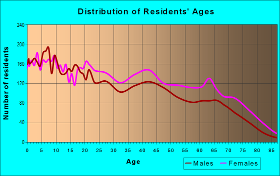
| Males: | 8,248 |
| Females: | 9,910 |
Males:
| This neighborhood: | 36.4 years |
| Whole city: | 34.4 years |
| This neighborhood: | 33.8 years |
| Whole city: | 34.7 years |
Average household size:
| South Union (Old Spanish Trail): | 9.5 people |
| Houston: | 2.4 people |
Percentage of family households:
| South Union (Old Spanish Trail): | 36.9% |
| Houston: | 43.0% |
| Here: | 22.1% |
| Houston: | 34.7% |
Percentage of married-couple families with children (among all households):
| South Union (Old Spanish Trail): | 29.7% |
| Houston: | 23.3% |
Percentage of single-mother households (among all households):
| South Union (Old Spanish Trail): | 15.7% |
| Houston: | 13.9% |
Percentage of never married males 15 years old and over:
Percentage of never married females 15 years old and over:
| South Union (Old Spanish Trail): | 20.0% |
| Houston: | 22.9% |
Percentage of never married females 15 years old and over:
| South Union (Old Spanish Trail): | 27.6% |
| city: | 21.2% |
Percentage of people that speak English not well or not at all:
| South Union (Old Spanish Trail): | 4.5% |
| Houston: | 15.9% |
Percentage of people born in this state:
Percentage of people born in another U.S. state:
Percentage of native residents but born outside the U.S.:
Percentage of foreign born residents:
| Here: | 70.7% |
| Houston: | 51.1% |
Percentage of people born in another U.S. state:
| South Union (Old Spanish Trail): | 17.4% |
| Houston: | 17.7% |
Percentage of native residents but born outside the U.S.:
| Here: | 0.8% |
| city: | 1.8% |
Percentage of foreign born residents:
| Here: | 11.3% |
| Houston: | 29.4% |

Owner-occupied
Renter-occupied


- Rooms in owner-occupied houses and condos in South Union <
> - 2941 room
- 02 rooms
- 1713 rooms
- 4844 rooms
- 1,0085 rooms
- 1,2276 rooms
- 5177 rooms
- 6638 rooms
- 2889+ rooms

- Rooms in renter-occupied apartments in South Union <
> - 7071 room
- 3832 rooms
- 1,3773 rooms
- 1,1614 rooms
- 9015 rooms
- 5966 rooms
- 5517 rooms
- 2028 rooms
- 09+ rooms
Owner-occupied
Renter-occupied

- Bedrooms in owner-occupied houses and condos in South Union <
> - 294no bedroom
- 2001 bedroom
- 8912 bedrooms
- 2,3053 bedrooms
- 5404 bedrooms
- 2065+ bedrooms

- Bedrooms in renter-occupied apartments in South Union <
> - 707no bedroom
- 1,3021 bedroom
- 1,6302 bedrooms
- 1,1253 bedrooms
- 4624 bedrooms
- 2205+ bedrooms
Average number of cars or other vehicles available in houses/condos:
Average number of cars or other vehicles available in apartments:
| This neighborhood: | 2.0 |
| Houston: | 2.0 |
Average number of cars or other vehicles available in apartments:
| Here: | 1.0 |
| city: | 1.3 |
Percentage of units with a mortgage:
| South Union (Old Spanish Trail): | 42.0% |
| Houston: | 50.8% |
Average estimated value of detached houses in 2022 (64.3% of all units):
| South Union (Old Spanish Trail): | $129,613 |
| Houston: | $368,067 |

- Year house built in South Union <
> - 8312020 or later
- 6102010 to 2019
- 1,1072000 to 2009
- 4971990 to 1999
- 7901980 to 1989
- 7151970 to 1979
- 1,1421960 to 1969
- 2,8301950 to 1959
- 1,9081940 to 1949
- 6291939 or earlier

City-data.com crime index for city in 2020 (higher means more crime):
| City: | 560.9 |
| U.S. average: | 219.5 |
Travel time to work (commute)
![Travel time to work (commute)]()
- 139Less than 5 minutes
- 1905 to 9 minutes
- 65910 to 14 minutes
- 1,17015 to 19 minutes
- 1,07820 to 24 minutes
- 24625 to 29 minutes
- 2,51930 to 34 minutes
- 11335 to 39 minutes
- 23440 to 44 minutes
- 57645 to 59 minutes
- 36460 to 89 minutes
- 43390 or more minutes

Means of transportation to work
![Means of transportation to work]()
- 69.4%5,024Drove a car alone
- 16.6%1,202Carpooled
- 8.4%608Bus
- 5.7%415Long-distance train or commuter rail
- 13.1%949Light rail, streetcar or trolley
- 1.2%90Motorcycle
- 1.0%74Bicycle
- 2.7%195Walked
- 4.1%297Other means
- 19.2%1,392Worked at home

Time leaving home to go to work
![Time leaving home to go to work]()
- 56312:00 a.m. to 4:59 a.m.
- 3495:00 a.m. to 5:29 a.m.
- 6445:30 a.m. to 5:59 a.m.
- 3436:00 a.m. to 6:29 a.m.
- 6806:30 a.m. to 6:59 a.m.
- 1,5287:00 a.m. to 7:29 a.m.
- 7497:30 a.m. to 7:59 a.m.
- 6818:00 a.m. to 8:29 a.m.
- 4088:30 a.m. to 8:59 a.m.
- 4579:00 a.m. to 9:59 a.m.
- 24610:00 a.m. to 10:59 a.m.
- 18811:00 a.m. to 11:59 a.m.
- 64912:00 p.m. to 3:59 p.m.
- 6254:00 p.m. to 11:59 p.m.

Occupations of males:
- Percentage of males in management occupations (except farmers):
Here: 10.0% city: 10.6%
- Percentage of males in business and financial operations occupations:
Here: 2.3% city: 5.4%
- Percentage of males in computer and mathematical occupations:
Here: 1.4% city: 3.9%
- Percentage of males in architecture and engineering occupations:
Here: 1.3% city: 4.0%
- Percentage of males in community and social services occupations:
Here: 2.7% city: 0.7%
- Percentage of males in education, training, and library occupations:
Here: 7.5% city: 3.1%
- Percentage of males in healthcare practitioners and technical occupations:
Here: 1.3% city: 2.7%
- Percentage of males in service occupations:
Here: 14.8% city: 12.9%
- Percentage of males in sales and office occupations:
Here: 18.3% city: 13.5%
- Percentage of males in construction, extraction, and maintenance occupations:
Here: 12.9% city: 15.7%
- Percentage of males in production occupations:
Here: 7.9% city: 6.0%
- Percentage of males in transportation occupations:
Here: 7.7% city: 6.1%
- Percentage of males in material moving occupations:
Here: 7.5% city: 5.4%
Occupations of females:
- Percentage of females in management occupations (except farmers):
Here: 2.5% city: 8.6%
- Percentage of females in business and financial operations occupations:
Here: 6.3% city: 6.8%
- Percentage of females in computer and mathematical occupations:
Here: 1.9% city: 1.7%
- Percentage of females in life, physical, and social science occupations:
Here: 2.2% city: 1.4%
- Percentage of females in community and social services occupations:
Here: 2.3% city: 1.8%
- Percentage of females in legal occupations:
Here: 3.4% city: 2.0%
- Percentage of females in education, training, and library occupations:
Here: 9.8% city: 8.5%
- Percentage of females in healthcare practitioners and technical occupations:
Here: 11.3% city: 8.1%
- Percentage of females in service occupations:
Here: 25.7% city: 23.8%
- Percentage of females in sales and office occupations:
Here: 30.5% city: 26.6%
- Percentage of females in material moving occupations:
Here: 2.7% city: 2.5%
Education in this neighborhood (subdivision or community):
- Percentage of people 3 years and older in K-12 schools:
South Union (Old Spanish Trail): 35.7% Houston: 16.6%
- Percentage of people 3 years and older in undergraduate colleges:
South Union (Old Spanish Trail): 10.0% Houston: 4.6%
- Percentage of people 3 years and older in grad. or professional schools:
South Union (Old Spanish Trail): 7.6% Houston: 1.6%
- Percentage of students K-12 enrolled in private schools:
South Union (Old Spanish Trail): 51.5% Houston: 9.0%
Percentage of population below poverty level:
| South Union (Old Spanish Trail): | 31.8% |
| Houston: | 20.7% |
Median year owner moved in (as recorded in 2022):
| South Union (Old Spanish Trail): | 2000 |
| Houston: | 2010 |
Percentage of married-couple families with both working:
| South Union (Old Spanish Trail): | 74.2% |
| Houston: | 54.9% |

- 58.4%Electricity
- 35.6%Utility gas
- 2.1%Bottled, tank, or LP gas
- 1.9%Coal or coke
- 1.9%No fuel used
Limited-access highways (interstate or state) in this neighborhood:
I- 610 (S Loop Fwy)
Length: 2.69 miles
Directions: E-W, SW-NE
Directions: E-W, SW-NE
Highways in this neighborhood:
US Hwy 90 Alt (Old Spanish Trl)
Length: 2.29 miles
Directions: E-W, SW-NE
Address range: 4116 to 4221
Directions: E-W, SW-NE
Address range: 4116 to 4221
State Hwy 288 (South Fwy)
Length: 0.57 miles
Direction: N-S
Direction: N-S
Roads and streets:
FM 865 N (Cullen Blvd, Co Rd 865)
Length: 3.19 miles
Directions: N-S, SW-NE
Address range: 5813 to 7333
Directions: N-S, SW-NE
Address range: 5813 to 7333
Yellowstone Blvd
Length: 2.50 miles
Direction: E-W
Address range: 3300 to 5199
Direction: E-W
Address range: 3300 to 5199
Martin Luther King Jr Blvd
Length: 2.13 miles
Directions: N-S, SE-NW, SW-NE
Address range: 4813 to 6400
Directions: N-S, SE-NW, SW-NE
Address range: 4813 to 6400
Cosby St
Length: 2.12 miles
Directions: E-W, SE-NW
Address range: 3600 to 5299
Directions: E-W, SE-NW
Address range: 3600 to 5299
Idaho St
Length: 2.04 miles
Directions: E-W, N-S, SW-NE
Address range: 3300 to 5199
Directions: E-W, N-S, SW-NE
Address range: 3300 to 5199
Ward St
Length: 1.91 miles
Directions: E-W, N-S, SE-NW
Address range: 3300 to 5099
Directions: E-W, N-S, SE-NW
Address range: 3300 to 5099
Griggs Rd
Length: 1.81 miles
Direction: E-W
Address range: 4190 to 5799
Direction: E-W
Address range: 4190 to 5799
Beekman Rd
Length: 1.59 miles
Directions: E-W, N-S, SE-NW, SW-NE
Address range: 4900 to 6599
Directions: E-W, N-S, SE-NW, SW-NE
Address range: 4900 to 6599
Perry St
Length: 1.57 miles
Directions: E-W, SE-NW
Address range: 3900 to 5299
Directions: E-W, SE-NW
Address range: 3900 to 5299
Scott St
Length: 1.57 miles
Directions: N-S, SW-NE
Address range: 6109 to 7598
Directions: N-S, SW-NE
Address range: 6109 to 7598
England St
Length: 1.56 miles
Directions: N-S, SW-NE
Address range: 5794 to 7399
Directions: N-S, SW-NE
Address range: 5794 to 7399
Balkin St
Length: 1.55 miles
Directions: E-W, N-S, SE-NW
Address range: 3900 to 5299
Directions: E-W, N-S, SE-NW
Address range: 3900 to 5299
Tierwester St
Length: 1.53 miles
Directions: N-S, SW-NE
Address range: 6424 to 7849
Directions: N-S, SW-NE
Address range: 6424 to 7849
Conley St
Length: 1.52 miles
Direction: N-S
Address range: 5800 to 7399
Direction: N-S
Address range: 5800 to 7399
Calhoun Rd (Calhoun St)
Length: 1.52 miles
Directions: N-S, SW-NE
Address range: 5425 to 6999
Directions: N-S, SW-NE
Address range: 5425 to 6999
Saint Augustine St
Length: 1.49 miles
Directions: N-S, SW-NE
Address range: 5800 to 7399
Directions: N-S, SW-NE
Address range: 5800 to 7399
Milart St
Length: 1.36 miles
Directions: N-S, SE-NW, SW-NE
Address range: 5000 to 6999
Directions: N-S, SE-NW, SW-NE
Address range: 5000 to 6999
Alice St
Length: 1.31 miles
Directions: E-W, SE-NW
Address range: 3310 to 4499
Directions: E-W, SE-NW
Address range: 3310 to 4499
Hull St
Length: 1.30 miles
Direction: E-W
Address range: 3900 to 5199
Direction: E-W
Address range: 3900 to 5199
Goforth St
Length: 1.23 miles
Direction: N-S
Address range: 5116 to 7199
Direction: N-S
Address range: 5116 to 7199
Foster St
Length: 1.23 miles
Directions: N-S, SW-NE
Address range: 5800 to 7199
Directions: N-S, SW-NE
Address range: 5800 to 7199
la Salette St
Length: 1.23 miles
Directions: N-S, SW-NE
Address range: 6202 to 7799
Directions: N-S, SW-NE
Address range: 6202 to 7799
Sidney St
Length: 1.23 miles
Directions: N-S, SW-NE
Address range: 5800 to 7199
Directions: N-S, SW-NE
Address range: 5800 to 7199
Corder Ave (Corder St)
Length: 1.17 miles
Directions: E-W, SE-NW
Address range: 3400 to 4015
Directions: E-W, SE-NW
Address range: 3400 to 4015
Eastwood St
Length: 1.09 miles
Directions: N-S, SW-NE
Address range: 5800 to 7199
Directions: N-S, SW-NE
Address range: 5800 to 7199
Faulkner St
Length: 1.05 miles
Directions: E-W, N-S, SE-NW
Address range: 3700 to 4499
Directions: E-W, N-S, SE-NW
Address range: 3700 to 4499
Dreyfus St
Length: 1.04 miles
Directions: E-W, N-S
Address range: 3500 to 4499
Directions: E-W, N-S
Address range: 3500 to 4499
Mainer St
Length: 1.02 miles
Directions: E-W, SE-NW, SW-NE
Address range: 3300 to 4299
Directions: E-W, SE-NW, SW-NE
Address range: 3300 to 4299
Daphne St
Length: 1.01 miles
Direction: E-W
Address range: 3300 to 3999
Direction: E-W
Address range: 3300 to 3999
Luca St
Length: 0.95 miles
Direction: E-W
Address range: 3300 to 3999
Direction: E-W
Address range: 3300 to 3999
Sherwood Dr
Length: 0.95 miles
Directions: N-S, SW-NE
Address range: 6100 to 7199
Directions: N-S, SW-NE
Address range: 6100 to 7199
Keystone St
Length: 0.90 miles
Directions: E-W, SE-NW
Address range: 4500 to 5399
Directions: E-W, SE-NW
Address range: 4500 to 5399
Dewberry St
Length: 0.90 miles
Directions: E-W, SE-NW
Address range: 4500 to 5399
Directions: E-W, SE-NW
Address range: 4500 to 5399
Mount Pleasant St
Length: 0.89 miles
Direction: E-W
Address range: 3400 to 3999
Direction: E-W
Address range: 3400 to 3999
Peerless St
Length: 0.88 miles
Directions: E-W, N-S, SW-NE
Address range: 6608 to 7216
Directions: E-W, N-S, SW-NE
Address range: 6608 to 7216
Kingsbury St
Length: 0.87 miles
Directions: E-W, SE-NW
Address range: 4500 to 5399
Directions: E-W, SE-NW
Address range: 4500 to 5399
New York St
Length: 0.85 miles
Directions: N-S, SW-NE
Address range: 6300 to 7099
Directions: N-S, SW-NE
Address range: 6300 to 7099
London St
Length: 0.84 miles
Directions: N-S, SW-NE
Address range: 6300 to 7199
Directions: N-S, SW-NE
Address range: 6300 to 7199
Holmes Rd
Length: 0.84 miles
Directions: E-W, SW-NE
Address range: 4200 to 4699
Directions: E-W, SW-NE
Address range: 4200 to 4699
Seabrook St
Length: 0.83 miles
Direction: E-W
Address range: 3400 to 3999
Direction: E-W
Address range: 3400 to 3999
Lydia St
Length: 0.83 miles
Directions: E-W, SE-NW
Address range: 3400 to 3899
Directions: E-W, SE-NW
Address range: 3400 to 3899
Good Hope St
Length: 0.82 miles
Direction: E-W
Address range: 3400 to 3899
Direction: E-W
Address range: 3400 to 3899
Noah St
Length: 0.82 miles
Direction: E-W
Address range: 3400 to 3899
Direction: E-W
Address range: 3400 to 3899
Rebecca St
Length: 0.78 miles
Directions: E-W, SE-NW
Address range: 3400 to 3899
Directions: E-W, SE-NW
Address range: 3400 to 3899
Zephyr St
Length: 0.78 miles
Directions: E-W, SE-NW
Address range: 3400 to 3999
Directions: E-W, SE-NW
Address range: 3400 to 3999
Arvilla Ln
Length: 0.77 miles
Direction: E-W
Address range: 4700 to 5199
Direction: E-W
Address range: 4700 to 5199
Liverpool St
Length: 0.72 miles
Directions: N-S, SW-NE
Address range: 6300 to 6999
Directions: N-S, SW-NE
Address range: 6300 to 6999
Paris St
Length: 0.72 miles
Directions: N-S, SW-NE
Address range: 6300 to 6999
Directions: N-S, SW-NE
Address range: 6300 to 6999
Dumble St
Length: 0.72 miles
Directions: N-S, SW-NE
Address range: 6300 to 7099
Directions: N-S, SW-NE
Address range: 6300 to 7099
Winnetka Ave (Winnetka St)
Length: 0.71 miles
Direction: E-W
Address range: 4700 to 5199
Direction: E-W
Address range: 4700 to 5199
Marietta Ln
Length: 0.70 miles
Direction: E-W
Address range: 4700 to 5099
Direction: E-W
Address range: 4700 to 5099
Winton St
Length: 0.67 miles
Directions: N-S, SW-NE
Address range: 6600 to 7099
Directions: N-S, SW-NE
Address range: 6600 to 7099
Madrid St
Length: 0.66 miles
Direction: N-S
Address range: 6300 to 6999
Direction: N-S
Address range: 6300 to 6999
Burkett St
Length: 0.66 miles
Direction: N-S
Address range: 6600 to 7199
Direction: N-S
Address range: 6600 to 7199
Weston St
Length: 0.65 miles
Directions: N-S, SW-NE
Address range: 6300 to 7099
Directions: N-S, SW-NE
Address range: 6300 to 7099
Nathaniel Brown St
Length: 0.64 miles
Direction: E-W
Address range: 3400 to 3799
Direction: E-W
Address range: 3400 to 3799
Enyart St
Length: 0.64 miles
Directions: E-W, SE-NW
Address range: 4900 to 5299
Directions: E-W, SE-NW
Address range: 4900 to 5299
del Rio St
Length: 0.63 miles
Directions: N-S, SW-NE
Address range: 6607 to 7199
Directions: N-S, SW-NE
Address range: 6607 to 7199
Dixie Dr
Length: 0.63 miles
Direction: E-W
Address range: 4000 to 4599
Direction: E-W
Address range: 4000 to 4599
Lozier St
Length: 0.63 miles
Direction: N-S
Address range: 6601 to 7099
Direction: N-S
Address range: 6601 to 7099
Grace Ln
Length: 0.62 miles
Directions: N-S, SW-NE
Address range: 5500 to 6299
Directions: N-S, SW-NE
Address range: 5500 to 6299
Nassau Rd
Length: 0.62 miles
Directions: E-W, N-S, SE-NW
Address range: 5000 to 5599
Directions: E-W, N-S, SE-NW
Address range: 5000 to 5599
Amos St
Length: 0.62 miles
Directions: E-W, N-S
Address range: 3500 to 3899
Directions: E-W, N-S
Address range: 3500 to 3899
Stearns St
Length: 0.59 miles
Directions: N-S, SW-NE
Address range: 6600 to 7099
Directions: N-S, SW-NE
Address range: 6600 to 7099
Southlawn St
Length: 0.59 miles
Directions: E-W, SE-NW
Address range: 3700 to 3999
Directions: E-W, SE-NW
Address range: 3700 to 3999
Cadillac St
Length: 0.59 miles
Direction: N-S
Address range: 6600 to 7099
Direction: N-S
Address range: 6600 to 7099
Springhill St
Length: 0.57 miles
Directions: N-S, SW-NE
Address range: 7100 to 7799
Directions: N-S, SW-NE
Address range: 7100 to 7799
Florinda St
Length: 0.55 miles
Direction: E-W
Address range: 3600 to 3999
Direction: E-W
Address range: 3600 to 3999
Alberta St
Length: 0.55 miles
Direction: E-W
Address range: 3600 to 3999
Direction: E-W
Address range: 3600 to 3999
Kelso St
Length: 0.55 miles
Directions: E-W, SE-NW
Address range: 4900 to 5299
Directions: E-W, SE-NW
Address range: 4900 to 5299
Alsace St
Length: 0.55 miles
Direction: E-W
Address range: 3600 to 3999
Direction: E-W
Address range: 3600 to 3999
Lehall St
Length: 0.55 miles
Direction: E-W
Address range: 3600 to 3899
Direction: E-W
Address range: 3600 to 3899
Porter Ave
Length: 0.52 miles
Directions: E-W, SE-NW
Address range: 3900 to 4411
Directions: E-W, SE-NW
Address range: 3900 to 4411
Browncroft St
Length: 0.48 miles
Direction: E-W
Address range: 5100 to 5399
Direction: E-W
Address range: 5100 to 5399
Cavanaugh St
Length: 0.47 miles
Directions: N-S, SE-NW, SW-NE
Address range: 5600 to 6199
Directions: N-S, SE-NW, SW-NE
Address range: 5600 to 6199
Ventura Ln
Length: 0.46 miles
Directions: E-W, SE-NW, SW-NE
Address range: 4800 to 5099
Directions: E-W, SE-NW, SW-NE
Address range: 4800 to 5099
Eppes St
Length: 0.44 miles
Directions: E-W, SW-NE
Address range: 4700 to 4999
Directions: E-W, SW-NE
Address range: 4700 to 4999
du Pont St
Length: 0.42 miles
Direction: E-W
Address range: 4000 to 4499
Direction: E-W
Address range: 4000 to 4499
Winfree Dr
Length: 0.42 miles
Direction: E-W
Address range: 4700 to 4999
Direction: E-W
Address range: 4700 to 4999
Bacon St
Length: 0.40 miles
Directions: E-W, SW-NE
Address range: 3400 to 3599
Directions: E-W, SW-NE
Address range: 3400 to 3599
Cortelyou Ln
Length: 0.39 miles
Direction: E-W
Address range: 5100 to 5399
Direction: E-W
Address range: 5100 to 5399
Stuyvesant Ln
Length: 0.39 miles
Direction: E-W
Address range: 5100 to 5399
Direction: E-W
Address range: 5100 to 5399
Culmore Dr
Length: 0.39 miles
Directions: E-W, SW-NE
Address range: 4800 to 4973
Directions: E-W, SW-NE
Address range: 4800 to 4973
Belvedere
Length: 0.37 miles
Directions: N-S, SE-NW, SW-NE
Address range: 4816 to 5799
Directions: N-S, SE-NW, SW-NE
Address range: 4816 to 5799
Dickens Rd
Length: 0.36 miles
Directions: N-S, SE-NW
Address range: 4900 to 5199
Directions: N-S, SE-NW
Address range: 4900 to 5199
Gren St
Length: 0.34 miles
Directions: E-W, N-S, SE-NW
Address range: 4900 to 5199
Directions: E-W, N-S, SE-NW
Address range: 4900 to 5199
Schroeder Rd
Length: 0.34 miles
Directions: N-S, SW-NE
Address range: 5800 to 6099
Directions: N-S, SW-NE
Address range: 5800 to 6099
Branch
Length: 0.32 miles
Direction: E-W
Address range: 4501 to 4799
Direction: E-W
Address range: 4501 to 4799
Wayland Dr (Wayland St)
Length: 0.32 miles
Directions: N-S, SE-NW
Address range: 5800 to 6299
Directions: N-S, SE-NW
Address range: 5800 to 6299
SE Tc Three Dr
Length: 0.29 miles
Directions: E-W, SE-NW, SW-NE
Directions: E-W, SE-NW, SW-NE
Gammage St
Length: 0.29 miles
Directions: E-W, SE-NW
Address range: 4900 to 5199
Directions: E-W, SE-NW
Address range: 4900 to 5199
Brookhaven St
Length: 0.28 miles
Directions: E-W, SE-NW, SW-NE
Address range: 4300 to 4499
Directions: E-W, SE-NW, SW-NE
Address range: 4300 to 4499
Pomander Rd
Length: 0.28 miles
Directions: E-W, N-S, SW-NE
Address range: 5201 to 5399
Directions: E-W, N-S, SW-NE
Address range: 5201 to 5399
Allegheny St
Length: 0.27 miles
Direction: N-S
Address range: 6652 to 6899
Direction: N-S
Address range: 6652 to 6899
Driftwood St
Length: 0.27 miles
Directions: N-S, SW-NE
Address range: 6700 to 6999
Directions: N-S, SW-NE
Address range: 6700 to 6999
Tristan St
Length: 0.27 miles
Direction: E-W
Address range: 3700 to 3999
Direction: E-W
Address range: 3700 to 3999
Newkirk Ln
Length: 0.25 miles
Directions: E-W, SE-NW
Address range: 5200 to 5499
Directions: E-W, SE-NW
Address range: 5200 to 5499
Yosemite St
Length: 0.24 miles
Direction: E-W
Address range: 3600 to 3799
Direction: E-W
Address range: 3600 to 3799
Alice
Length: 0.24 miles
Direction: E-W
Direction: E-W
Wyoming St
Length: 0.24 miles
Direction: E-W
Address range: 3600 to 3799
Direction: E-W
Address range: 3600 to 3799
Andrea St
Length: 0.24 miles
Direction: E-W
Address range: 4900 to 5099
Direction: E-W
Address range: 4900 to 5099
Weingarten St
Length: 0.22 miles
Direction: E-W
Address range: 4500 to 4599
Direction: E-W
Address range: 4500 to 4599
Lisa Ln
Length: 0.22 miles
Direction: N-S
Address range: 6000 to 6099
Direction: N-S
Address range: 6000 to 6099
Normandy Way
Length: 0.21 miles
Direction: E-W
Address range: 4500 to 4599
Direction: E-W
Address range: 4500 to 4599
Willowbrook Blvd
Length: 0.21 miles
Direction: E-W
Address range: 4500 to 4599
Direction: E-W
Address range: 4500 to 4599
Short St
Length: 0.21 miles
Direction: E-W
Address range: 4000 to 4299
Direction: E-W
Address range: 4000 to 4299
Albemarle Ln
Length: 0.21 miles
Directions: E-W, SE-NW
Address range: 5150 to 5299
Directions: E-W, SE-NW
Address range: 5150 to 5299
Tallow Ln
Length: 0.19 miles
Direction: N-S
Address range: 5300 to 5699
Direction: N-S
Address range: 5300 to 5699
Carol Ln
Length: 0.19 miles
Directions: E-W, N-S
Address range: 5800 to 6199
Directions: E-W, N-S
Address range: 5800 to 6199
Madalyn Ln
Length: 0.19 miles
Direction: E-W
Address range: 5000 to 5099
Direction: E-W
Address range: 5000 to 5099
Lydia
Length: 0.19 miles
Direction: E-W
Direction: E-W
Stearns
Length: 0.18 miles
Directions: N-S, SW-NE
Directions: N-S, SW-NE
Mykawa Rd
Length: 0.18 miles
Direction: N-S
Direction: N-S
Saint Benedict St
Length: 0.18 miles
Direction: E-W
Address range: 3400 to 3499
Direction: E-W
Address range: 3400 to 3499
Sunrise Rd
Length: 0.17 miles
Directions: N-S, SW-NE
Address range: 5300 to 5799
Directions: N-S, SW-NE
Address range: 5300 to 5799
Idaho
Length: 0.17 miles
Direction: E-W
Direction: E-W
Scottcrest Dr
Length: 0.17 miles
Directions: E-W, N-S, SW-NE
Address range: 6008 to 6299
Directions: E-W, N-S, SW-NE
Address range: 6008 to 6299
Tolnay Ave (Tolnay St)
Length: 0.16 miles
Directions: E-W, SE-NW
Address range: 3900 to 3999
Directions: E-W, SE-NW
Address range: 3900 to 3999
Beachwood St
Length: 0.16 miles
Directions: N-S, SW-NE
Address range: 6800 to 6999
Directions: N-S, SW-NE
Address range: 6800 to 6999
Mount Pleasant Cir
Length: 0.16 miles
Directions: E-W, N-S, SE-NW, SW-NE
Address range: 3901 to 3999
Directions: E-W, N-S, SE-NW, SW-NE
Address range: 3901 to 3999
Swanson St
Length: 0.16 miles
Direction: E-W
Address range: 4500 to 4599
Direction: E-W
Address range: 4500 to 4599
Blythewood St
Length: 0.15 miles
Directions: E-W, N-S, SE-NW
Address range: 5612 to 5799
Directions: E-W, N-S, SE-NW
Address range: 5612 to 5799
Lehall
Length: 0.14 miles
Directions: E-W, SE-NW
Directions: E-W, SE-NW
Faulkner
Length: 0.13 miles
Direction: E-W
Direction: E-W
Tierwester Village St
Length: 0.13 miles
Direction: E-W
Direction: E-W
Wayland
Length: 0.12 miles
Direction: N-S
Direction: N-S
Penfield Ln
Length: 0.11 miles
Direction: E-W
Address range: 5200 to 5299
Direction: E-W
Address range: 5200 to 5299
Lady St
Length: 0.11 miles
Direction: N-S
Address range: 7600 to 7699
Direction: N-S
Address range: 7600 to 7699
Royal Palms St (Royal Palms Dr)
Length: 0.11 miles
Direction: SW-NE
Address range: 5600 to 5799
Direction: SW-NE
Address range: 5600 to 5799
Holly Hall St
Length: 0.10 miles
Direction: E-W
Address range: 3300 to 3399
Direction: E-W
Address range: 3300 to 3399
Radial St
Length: 0.10 miles
Directions: E-W, SE-NW
Address range: 4900 to 4999
Directions: E-W, SE-NW
Address range: 4900 to 4999
Luca
Length: 0.10 miles
Direction: E-W
Direction: E-W
Mosside St
Length: 0.09 miles
Direction: N-S
Address range: 7600 to 7699
Direction: N-S
Address range: 7600 to 7699
S Loop Fwy (Brookhaven St)
Length: 0.09 miles
Direction: E-W
Direction: E-W
Sidney
Length: 0.09 miles
Direction: N-S
Direction: N-S
Raymond St
Length: 0.09 miles
Direction: N-S
Address range: 7100 to 7199
Direction: N-S
Address range: 7100 to 7199
Niagara St
Length: 0.08 miles
Direction: N-S
Address range: 900 to 999
Direction: N-S
Address range: 900 to 999
Ditmas Ln
Length: 0.08 miles
Direction: E-W
Address range: 5100 to 5199
Direction: E-W
Address range: 5100 to 5199
Mainer
Length: 0.07 miles
Direction: E-W
Direction: E-W
Calais Rd
Length: 0.06 miles
Directions: N-S, SE-NW
Directions: N-S, SE-NW
Mt Pleasant St
Length: 0.05 miles
Direction: SE-NW
Direction: SE-NW
Long Dr
Length: 0.05 miles
Direction: E-W
Direction: E-W
Lozier
Length: 0.05 miles
Direction: N-S
Direction: N-S
Cadillac
Length: 0.05 miles
Direction: N-S
Direction: N-S
Nassau Ct
Length: 0.03 miles
Direction: SW-NE
Address range: 5100 to 5199
Direction: SW-NE
Address range: 5100 to 5199
Crestmont Rd
Length: 0.02 miles
Direction: SE-NW
Direction: SE-NW
Railroad features:
Southern Pacific RR
Length: 2.78 miles
Directions: E-W, N-S, SW-NE
Directions: E-W, N-S, SW-NE