Richfield neighborhood in Clifton, New Jersey (NJ), 07012, 07013 detailed profile
Settings
X


Business Search - 14 Million verified businesses
Area: 1.446 square miles
Population: 10,355
Population density:
| Richfield: | 7,160 people per square mile |
| Clifton: | 7,855 people per square mile |

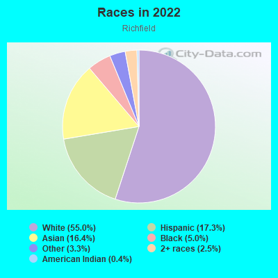
- 6,05455.0%White
- 1,90317.3%Hispanic or Latino
- 1,80616.4%Asian
- 5545.0%Black
- 3633.3%Some other race
- 2742.5%Two or more races
- 480.4%American Indian
Distribution of median household income
![Distribution of median household income]()
- 233Less than $10,000
- 629$10,000 to $19,999
- 388$20,000 to $29,999
- 251$30,000 to $39,999
- 318$40,000 to $49,999
- 402$50,000 to $59,999
- 537$60,000 to $74,999
- 665$75,000 to $99,999
- 340$100,000 to $124,999
- 344$125,000 to $149,999
- 712$150,000 to $199,999
- 976$200,000 or more

Distribution of owner-occupied house/condo value
![Distribution of owner-occupied house/condo value]()
- 373Less than $50,000
- 416$50,000 to $99,999
- 679$100,000 to $149,999
- 993$150,000 to $199,999
- 203$200,000 to $249,999
- 105$250,000 to $299,999
- 561$300,000 to $399,999
- 1,009$400,000 to $499,999
- 654$500,000 to $749,999
- 299$750,000 to $999,999
- 97$1,000,000 or more

Distribution of rent paid by renters
![Distribution of rent paid by renters]()
- 115Less than $100
- 73$100 to $199
- 133$200 to $299
- 47$300 to $399
- 53$400 to $499
- 211$500 to $599
- 276$600 to $699
- 58$700 to $799
- 380$800 to $899
- 478$900 to $999
- 351$1,000 to $1,249
- 684$1,250 to $1,499
- 1,463$1,500 to $1,999
- 999$2,000 or more

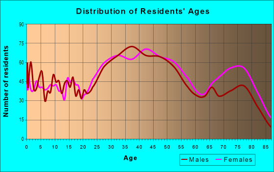
| Males: | 5,019 |
| Females: | 5,336 |
Males:
| This neighborhood: | 44.2 years |
| Whole city: | 39.2 years |
| This neighborhood: | 46.1 years |
| Whole city: | 40.5 years |
Average household size:
| Richfield: | 2.4 people |
| Clifton: | 2.5 people |
Percentage of family households:
| Richfield: | 45.1% |
| Clifton: | 45.4% |
| Here: | 48.8% |
| Clifton: | 46.6% |
Percentage of married-couple families with children (among all households):
| Richfield: | 38.3% |
| Clifton: | 30.6% |
Percentage of single-mother households (among all households):
| Richfield: | 8.8% |
| Clifton: | 5.7% |
Percentage of never married males 15 years old and over:
Percentage of never married females 15 years old and over:
| Richfield: | 16.5% |
| Clifton: | 18.6% |
Percentage of never married females 15 years old and over:
| Richfield: | 17.0% |
| city: | 16.0% |
Percentage of people that speak English not well or not at all:
| Richfield: | 4.7% |
| Clifton: | 8.4% |
Percentage of people born in this state:
Percentage of people born in another U.S. state:
Percentage of native residents but born outside the U.S.:
Percentage of foreign born residents:
| Here: | 52.7% |
| Clifton: | 47.6% |
Percentage of people born in another U.S. state:
| Richfield: | 18.1% |
| Clifton: | 14.4% |
Percentage of native residents but born outside the U.S.:
| Here: | 2.1% |
| city: | 4.9% |
Percentage of foreign born residents:
| Here: | 27.1% |
| Clifton: | 33.1% |
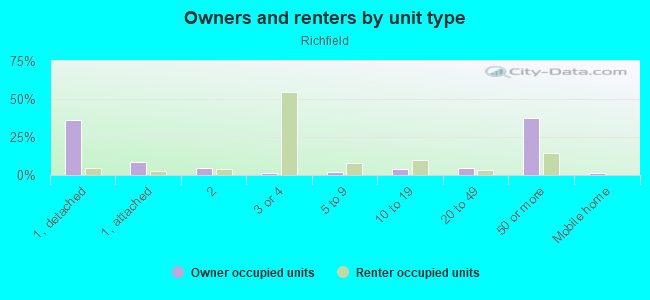
Owner-occupied
Renter-occupied

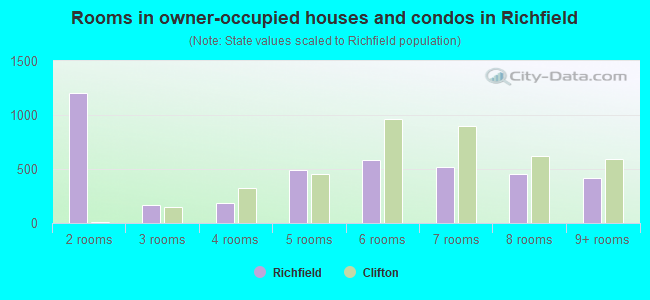
- Rooms in owner-occupied houses and condos in Richfield
- 01 room
- 1,2012 rooms
- 1653 rooms
- 1844 rooms
- 4925 rooms
- 5816 rooms
- 5167 rooms
- 4558 rooms
- 4189+ rooms
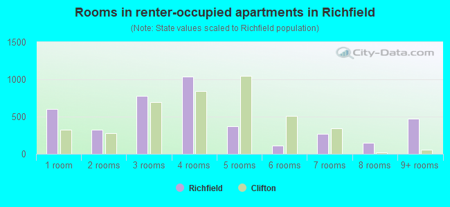
- Rooms in renter-occupied apartments in Richfield
- 6001 room
- 3272 rooms
- 7803 rooms
- 1,0354 rooms
- 3705 rooms
- 1136 rooms
- 2727 rooms
- 1498 rooms
- 4749+ rooms
Owner-occupied
Renter-occupied
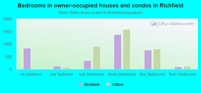
- Bedrooms in owner-occupied houses and condos in Richfield
- 834no bedroom
- 1241 bedroom
- 3402 bedrooms
- 1,3823 bedrooms
- 7644 bedrooms
- 1005+ bedrooms
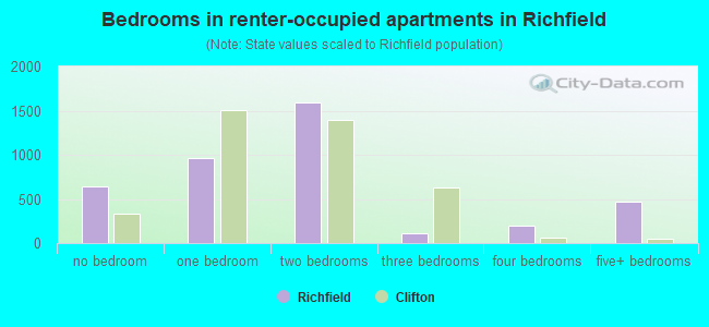
- Bedrooms in renter-occupied apartments in Richfield
- 640no bedroom
- 9651 bedroom
- 1,5982 bedrooms
- 1113 bedrooms
- 1964 bedrooms
- 4745+ bedrooms
Average number of cars or other vehicles available in houses/condos:
Average number of cars or other vehicles available in apartments:
| This neighborhood: | 2.0 |
| Clifton: | 2.0 |
Average number of cars or other vehicles available in apartments:
| Here: | |
| city: |
Percentage of units with a mortgage:
| Richfield: | 58.3% |
| Clifton: | 62.1% |
Average estimated value of detached houses in 2022 (53.3% of all units):
| Richfield: | $463,842 |
| Clifton: | $403,256 |
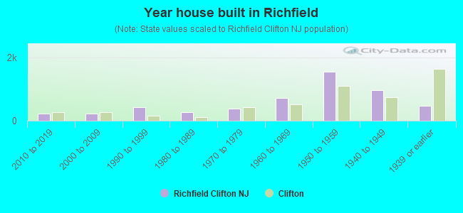
- Year house built in Richfield
- 02020 or later
- 2152010 to 2019
- 2212000 to 2009
- 4371990 to 1999
- 2681980 to 1989
- 3881970 to 1979
- 7271960 to 1969
- 1,5521950 to 1959
- 9581940 to 1949
- 4721939 or earlier
City-data.com crime index for city in 2020 (higher means more crime):
| City: | 98.9 |
| U.S. average: | 219.5 |
Travel time to work (commute)
![Travel time to work (commute)]()
- 177Less than 5 minutes
- 3145 to 9 minutes
- 73810 to 14 minutes
- 59815 to 19 minutes
- 66220 to 24 minutes
- 27325 to 29 minutes
- 84330 to 34 minutes
- 11435 to 39 minutes
- 19140 to 44 minutes
- 60245 to 59 minutes
- 54360 to 89 minutes
- 15590 or more minutes

Means of transportation to work
![Means of transportation to work]()
- 72.2%4,107Drove a car alone
- 6.7%379Carpooled
- 7.8%443Bus
- 4.9%277Subway or elevated rail
- 4.5%255Long-distance train or commuter rail
- 0.4%24Taxi
- 0.6%36Bicycle
- 9.1%519Walked
- 2.4%137Other means
- 8.5%484Worked at home

Time leaving home to go to work
![Time leaving home to go to work]()
- 14312:00 a.m. to 4:59 a.m.
- 1155:00 a.m. to 5:29 a.m.
- 1355:30 a.m. to 5:59 a.m.
- 3016:00 a.m. to 6:29 a.m.
- 3886:30 a.m. to 6:59 a.m.
- 8357:00 a.m. to 7:29 a.m.
- 6307:30 a.m. to 7:59 a.m.
- 7998:00 a.m. to 8:29 a.m.
- 4528:30 a.m. to 8:59 a.m.
- 5819:00 a.m. to 9:59 a.m.
- 13910:00 a.m. to 10:59 a.m.
- 4711:00 a.m. to 11:59 a.m.
- 35112:00 p.m. to 3:59 p.m.
- 2294:00 p.m. to 11:59 p.m.

Occupations of males:
- Percentage of males in management occupations (except farmers):
Here: 17.1% city: 11.9%
- Percentage of males in business and financial operations occupations:
Here: 7.4% city: 5.1%
- Percentage of males in computer and mathematical occupations:
Here: 11.2% city: 4.7%
- Percentage of males in architecture and engineering occupations:
Here: 4.8% city: 4.0%
- Percentage of males in life, physical, and social science occupations:
Here: 1.8% city: 1.3%
- Percentage of males in education, training, and library occupations:
Here: 3.1% city: 3.9%
- Percentage of males in arts, design, entertainment, sports, and media occupations:
Here: 2.0% city: 1.8%
- Percentage of males in healthcare practitioners and technical occupations:
Here: 5.5% city: 2.7%
- Percentage of males in service occupations:
Here: 9.4% city: 12.4%
- Percentage of males in sales and office occupations:
Here: 13.9% city: 15.0%
- Percentage of males in construction, extraction, and maintenance occupations:
Here: 6.6% city: 6.5%
- Percentage of males in production occupations:
Here: 5.1% city: 9.1%
- Percentage of males in transportation occupations:
Here: 2.0% city: 8.9%
- Percentage of males in material moving occupations:
Here: 4.6% city: 4.3%
Occupations of females:
- Percentage of females in management occupations (except farmers):
Here: 13.0% city: 8.6%
- Percentage of females in business and financial operations occupations:
Here: 8.3% city: 7.8%
- Percentage of females in computer and mathematical occupations:
Here: 1.4% city: 1.1%
- Percentage of females in life, physical, and social science occupations:
Here: 2.0% city: 1.6%
- Percentage of females in community and social services occupations:
Here: 1.1% city: 1.9%
- Percentage of females in legal occupations:
Here: 3.2% city: 1.7%
- Percentage of females in education, training, and library occupations:
Here: 7.1% city: 9.8%
- Percentage of females in arts, design, entertainment, sports, and media occupations:
Here: 2.8% city: 2.1%
- Percentage of females in healthcare practitioners and technical occupations:
Here: 15.9% city: 8.5%
- Percentage of females in service occupations:
Here: 12.3% city: 17.9%
- Percentage of females in sales and office occupations:
Here: 29.6% city: 28.5%
- Percentage of females in material moving occupations:
Here: 1.8% city: 2.4%
Education in this neighborhood (subdivision or community):
- Percentage of people 3 years and older in K-12 schools:
Richfield: 19.9% Clifton: 14.4%
- Percentage of people 3 years and older in undergraduate colleges:
Richfield: 7.1% Clifton: 6.2%
- Percentage of people 3 years and older in grad. or professional schools:
Richfield: 4.9% Clifton: 2.0%
- Percentage of students K-12 enrolled in private schools:
Richfield: 82.7% Clifton: 20.0%
Percentage of population below poverty level:
| Richfield: | 6.8% |
| Clifton: | 5.4% |
Median year owner moved in (as recorded in 2022):
| Richfield: | 2004 |
| Clifton: | 2009 |
Percentage of married-couple families with both working:
| Richfield: | 89.0% |
| Clifton: | 72.6% |
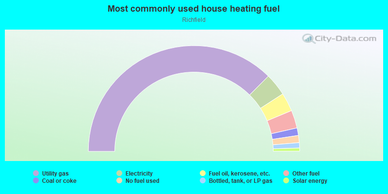
- 74.9%Utility gas
- 6.9%Electricity
- 5.7%Fuel oil, kerosene, etc.
- 5.5%Other fuel
- 2.3%Coal or coke
- 2.2%No fuel used
- 1.6%Bottled, tank, or LP gas
- 1.0%Solar energy
Highways in this neighborhood:
State Rte 3
Length: 2.97 miles
Directions: N-S, SE-NW
Address range: 1691 to 1699
Directions: N-S, SE-NW
Address range: 1691 to 1699
Garden State Pkwy
Length: 2.51 miles
Directions: N-S, SW-NE
Directions: N-S, SW-NE
Broad St (State Rte 509)
Length: 2.01 miles
Directions: N-S, SE-NW, SW-NE
Address range: 417 to 1208
Directions: N-S, SE-NW, SW-NE
Address range: 417 to 1208
Clifton Ave (State Rte 161)
Length: 1.39 miles
Directions: E-W, N-S, SE-NW, SW-NE
Address range: 903 to 1399
Directions: E-W, N-S, SE-NW, SW-NE
Address range: 903 to 1399
US Hwy 46
Length: 0.54 miles
Direction: E-W
Direction: E-W
Roads and streets:
Van Houten Ave (Passaic County 614)
Length: 1.40 miles
Directions: E-W, SE-NW
Address range: 839 to 1346
Directions: E-W, SE-NW
Address range: 839 to 1346
Mount Prospect Ave
Length: 1.25 miles
Direction: SW-NE
Address range: 139 to 613
Direction: SW-NE
Address range: 139 to 613
Grove St
Length: 1.01 miles
Direction: SW-NE
Address range: 90 to 548
Direction: SW-NE
Address range: 90 to 548
Pershing Rd
Length: 0.87 miles
Direction: SW-NE
Address range: 20 to 335
Direction: SW-NE
Address range: 20 to 335
Passaic County 602 (Allwood Rd)
Length: 0.86 miles
Direction: SE-NW
Address range: 870 to 1060
Direction: SE-NW
Address range: 870 to 1060
Urma Ave
Length: 0.78 miles
Directions: N-S, SE-NW, SW-NE
Address range: 1 to 299
Directions: N-S, SE-NW, SW-NE
Address range: 1 to 299
Starmond Ave
Length: 0.68 miles
Directions: E-W, SW-NE
Address range: 1 to 252
Directions: E-W, SW-NE
Address range: 1 to 252
Highview Dr
Length: 0.59 miles
Directions: E-W, N-S, SE-NW, SW-NE
Address range: 18 to 248
Directions: E-W, N-S, SE-NW, SW-NE
Address range: 18 to 248
Notch Rd
Length: 0.58 miles
Direction: SE-NW
Address range: 1 to 208
Direction: SE-NW
Address range: 1 to 208
Saint Andrews Blvd
Length: 0.57 miles
Directions: E-W, SE-NW
Address range: 1 to 199
Directions: E-W, SE-NW
Address range: 1 to 199
Oakridge Rd
Length: 0.54 miles
Directions: E-W, N-S, SE-NW, SW-NE
Address range: 1 to 199
Directions: E-W, N-S, SE-NW, SW-NE
Address range: 1 to 199
Friar Ln
Length: 0.53 miles
Directions: E-W, N-S, SE-NW, SW-NE
Address range: 1 to 218
Directions: E-W, N-S, SE-NW, SW-NE
Address range: 1 to 218
Doherty Dr
Length: 0.49 miles
Directions: E-W, N-S, SE-NW, SW-NE
Address range: 1 to 198
Directions: E-W, N-S, SE-NW, SW-NE
Address range: 1 to 198
Huemmer Ter
Length: 0.45 miles
Directions: E-W, N-S, SE-NW, SW-NE
Address range: 1 to 162
Directions: E-W, N-S, SE-NW, SW-NE
Address range: 1 to 162
Staudtmauer Dr
Length: 0.44 miles
Directions: E-W, N-S, SE-NW, SW-NE
Address range: 1 to 121
Directions: E-W, N-S, SE-NW, SW-NE
Address range: 1 to 121
Broadale Rd (Broadale Ave)
Length: 0.44 miles
Directions: E-W, SW-NE
Address range: 1 to 117
Directions: E-W, SW-NE
Address range: 1 to 117
Avondale Ave
Length: 0.43 miles
Directions: E-W, N-S, SE-NW, SW-NE
Address range: 3 to 162
Directions: E-W, N-S, SE-NW, SW-NE
Address range: 3 to 162
Brookwood Rd
Length: 0.42 miles
Direction: SW-NE
Address range: 1 to 162
Direction: SW-NE
Address range: 1 to 162
Greenlawn Ave
Length: 0.40 miles
Direction: SE-NW
Address range: 1 to 151
Direction: SE-NW
Address range: 1 to 151
Richfield Ter
Length: 0.38 miles
Direction: SW-NE
Address range: 1 to 242
Direction: SW-NE
Address range: 1 to 242
Barnsdale Rd
Length: 0.38 miles
Directions: N-S, SE-NW, SW-NE
Address range: 1 to 103
Directions: N-S, SE-NW, SW-NE
Address range: 1 to 103
Greg Lawn Dr
Length: 0.36 miles
Direction: SE-NW
Address range: 1 to 146
Direction: SE-NW
Address range: 1 to 146
Thanksgiving Ln
Length: 0.34 miles
Directions: E-W, SE-NW, SW-NE
Address range: 1 to 137
Directions: E-W, SE-NW, SW-NE
Address range: 1 to 137
St James Pl
Length: 0.34 miles
Direction: SE-NW
Address range: 1 to 85
Direction: SE-NW
Address range: 1 to 85
Field Rd
Length: 0.33 miles
Directions: E-W, SE-NW, SW-NE
Address range: 1 to 117
Directions: E-W, SE-NW, SW-NE
Address range: 1 to 117
Sycamore Rd
Length: 0.30 miles
Directions: E-W, SE-NW, SW-NE
Address range: 1 to 148
Directions: E-W, SE-NW, SW-NE
Address range: 1 to 148
Larkspur Ln
Length: 0.29 miles
Directions: N-S, SE-NW, SW-NE
Address range: 1 to 107
Directions: N-S, SE-NW, SW-NE
Address range: 1 to 107
Hutton Rd
Length: 0.29 miles
Directions: E-W, N-S, SE-NW, SW-NE
Address range: 31 to 133
Directions: E-W, N-S, SE-NW, SW-NE
Address range: 31 to 133
Pilgrim Dr
Length: 0.28 miles
Directions: E-W, SE-NW, SW-NE
Address range: 1 to 120
Directions: E-W, SE-NW, SW-NE
Address range: 1 to 120
Donna Dr
Length: 0.27 miles
Directions: E-W, N-S, SW-NE
Address range: 1 to 99
Directions: E-W, N-S, SW-NE
Address range: 1 to 99
Luisser St
Length: 0.27 miles
Directions: N-S, SW-NE
Address range: 1 to 112
Directions: N-S, SW-NE
Address range: 1 to 112
Village Rd
Length: 0.27 miles
Directions: E-W, SE-NW, SW-NE
Address range: 1 to 98
Directions: E-W, SE-NW, SW-NE
Address range: 1 to 98
Karen Dr
Length: 0.27 miles
Directions: E-W, N-S, SE-NW
Address range: 1 to 85
Directions: E-W, N-S, SE-NW
Address range: 1 to 85
Addison Pl
Length: 0.27 miles
Directions: N-S, SE-NW, SW-NE
Address range: 1 to 104
Directions: N-S, SE-NW, SW-NE
Address range: 1 to 104
Hemlock St
Length: 0.27 miles
Directions: E-W, SE-NW
Address range: 1 to 125
Directions: E-W, SE-NW
Address range: 1 to 125
Standish Dr
Length: 0.27 miles
Directions: E-W, N-S, SE-NW, SW-NE
Address range: 1 to 99
Directions: E-W, N-S, SE-NW, SW-NE
Address range: 1 to 99
Dalewood Rd
Length: 0.26 miles
Directions: E-W, SE-NW
Address range: 1 to 99
Directions: E-W, SE-NW
Address range: 1 to 99
Hepburn Rd
Length: 0.26 miles
Directions: E-W, SW-NE
Address range: 1 to 95
Directions: E-W, SW-NE
Address range: 1 to 95
Greendale Rd
Length: 0.24 miles
Direction: SE-NW
Address range: 1 to 99
Direction: SE-NW
Address range: 1 to 99
Richfield Ct
Length: 0.24 miles
Directions: E-W, SW-NE
Directions: E-W, SW-NE
Priscilla St
Length: 0.24 miles
Direction: SW-NE
Address range: 1 to 99
Direction: SW-NE
Address range: 1 to 99
Runyon Rd
Length: 0.24 miles
Directions: N-S, SE-NW, SW-NE
Address range: 1 to 99
Directions: N-S, SE-NW, SW-NE
Address range: 1 to 99
Braun Pl
Length: 0.23 miles
Direction: E-W
Address range: 8 to 98
Direction: E-W
Address range: 8 to 98
Brookside Dr
Length: 0.23 miles
Directions: E-W, SE-NW
Address range: 1 to 76
Directions: E-W, SE-NW
Address range: 1 to 76
Forest Way
Length: 0.22 miles
Direction: SE-NW
Address range: 1 to 87
Direction: SE-NW
Address range: 1 to 87
Doremus Pl
Length: 0.21 miles
Direction: SE-NW
Address range: 1 to 114
Direction: SE-NW
Address range: 1 to 114
Bennington Ct
Length: 0.21 miles
Directions: N-S, SE-NW, SW-NE
Address range: 173 to 258
Directions: N-S, SE-NW, SW-NE
Address range: 173 to 258
Martindale Rd
Length: 0.21 miles
Directions: E-W, SW-NE
Address range: 1 to 77
Directions: E-W, SW-NE
Address range: 1 to 77
Olga B Ter
Length: 0.20 miles
Direction: SE-NW
Address range: 1 to 68
Direction: SE-NW
Address range: 1 to 68
Hackberry Pl
Length: 0.19 miles
Direction: SE-NW
Address range: 24 to 99
Direction: SE-NW
Address range: 24 to 99
Rosedale Ave
Length: 0.19 miles
Direction: SE-NW
Address range: 1 to 72
Direction: SE-NW
Address range: 1 to 72
Sunnycrest Ave
Length: 0.19 miles
Directions: E-W, SE-NW
Address range: 1 to 66
Directions: E-W, SE-NW
Address range: 1 to 66
Lockwood Pl
Length: 0.19 miles
Directions: E-W, N-S, SE-NW
Address range: 1 to 87
Directions: E-W, N-S, SE-NW
Address range: 1 to 87
Lennon Pl
Length: 0.18 miles
Directions: N-S, SE-NW, SW-NE
Address range: 1 to 80
Directions: N-S, SE-NW, SW-NE
Address range: 1 to 80
John Alden St
Length: 0.17 miles
Directions: N-S, SE-NW, SW-NE
Address range: 1 to 64
Directions: N-S, SE-NW, SW-NE
Address range: 1 to 64
Springdale Ct
Length: 0.16 miles
Directions: N-S, SE-NW, SW-NE
Address range: 1 to 56
Directions: N-S, SE-NW, SW-NE
Address range: 1 to 56
Springdale Ave
Length: 0.16 miles
Direction: SE-NW
Address range: 1 to 62
Direction: SE-NW
Address range: 1 to 62
Mayflower St
Length: 0.16 miles
Directions: N-S, SE-NW, SW-NE
Address range: 1 to 56
Directions: N-S, SE-NW, SW-NE
Address range: 1 to 56
Kowal St
Length: 0.15 miles
Directions: SE-NW, SW-NE
Directions: SE-NW, SW-NE
Graydon Ter
Length: 0.15 miles
Direction: SW-NE
Address range: 1 to 53
Direction: SW-NE
Address range: 1 to 53
Hooyman Dr
Length: 0.15 miles
Direction: SW-NE
Address range: 25 to 85
Direction: SW-NE
Address range: 25 to 85
Doherty Dr E
Length: 0.15 miles
Directions: N-S, SE-NW, SW-NE
Address range: 1 to 66
Directions: N-S, SE-NW, SW-NE
Address range: 1 to 66
Dianne Ct
Length: 0.15 miles
Directions: N-S, SE-NW
Address range: 1 to 65
Directions: N-S, SE-NW
Address range: 1 to 65
Hamas St
Length: 0.14 miles
Direction: SE-NW
Address range: 1 to 44
Direction: SE-NW
Address range: 1 to 44
Holly St
Length: 0.14 miles
Direction: SE-NW
Address range: 1 to 45
Direction: SE-NW
Address range: 1 to 45
Barberry Ln
Length: 0.14 miles
Direction: SW-NE
Address range: 1 to 56
Direction: SW-NE
Address range: 1 to 56
Joan Pl
Length: 0.13 miles
Directions: E-W, SE-NW
Address range: 1 to 58
Directions: E-W, SE-NW
Address range: 1 to 58
Lawrence Ct
Length: 0.13 miles
Direction: SE-NW
Direction: SE-NW
Godwin Pl
Length: 0.13 miles
Direction: SE-NW
Address range: 1 to 56
Direction: SE-NW
Address range: 1 to 56
Plymouth Rd
Length: 0.13 miles
Directions: E-W, SE-NW
Address range: 1 to 47
Directions: E-W, SE-NW
Address range: 1 to 47
Van Vliet Ct
Length: 0.13 miles
Direction: SW-NE
Address range: 2 to 56
Direction: SW-NE
Address range: 2 to 56
Landis Pl
Length: 0.12 miles
Direction: SE-NW
Address range: 1 to 50
Direction: SE-NW
Address range: 1 to 50
Jani Ct
Length: 0.12 miles
Direction: SE-NW
Address range: 1 to 47
Direction: SE-NW
Address range: 1 to 47
Richland Ct
Length: 0.12 miles
Direction: E-W
Address range: 1 to 53
Direction: E-W
Address range: 1 to 53
Duane Rd
Length: 0.12 miles
Directions: E-W, SE-NW
Address range: 1 to 42
Directions: E-W, SE-NW
Address range: 1 to 42
Knox Pl
Length: 0.11 miles
Direction: SE-NW
Address range: 1 to 44
Direction: SE-NW
Address range: 1 to 44
Hickory St
Length: 0.11 miles
Direction: SW-NE
Address range: 29 to 76
Direction: SW-NE
Address range: 29 to 76
Passaic County 602 N
Length: 0.11 miles
Direction: SE-NW
Direction: SE-NW
Saint Michaels Pl
Length: 0.11 miles
Direction: SE-NW
Address range: 1 to 26
Direction: SE-NW
Address range: 1 to 26
Lynn Dr
Length: 0.10 miles
Directions: E-W, SE-NW, SW-NE
Address range: 1 to 34
Directions: E-W, SE-NW, SW-NE
Address range: 1 to 34
Lindale Ct
Length: 0.09 miles
Direction: SW-NE
Address range: 2 to 68
Direction: SW-NE
Address range: 2 to 68
Thornton Pl
Length: 0.09 miles
Direction: SW-NE
Address range: 1 to 40
Direction: SW-NE
Address range: 1 to 40
Chanda Ct
Length: 0.09 miles
Direction: SW-NE
Address range: 1 to 40
Direction: SW-NE
Address range: 1 to 40
Weeks Ct
Length: 0.09 miles
Direction: SW-NE
Address range: 1 to 44
Direction: SW-NE
Address range: 1 to 44
Dwight Ter
Length: 0.08 miles
Direction: SE-NW
Address range: 1 to 34
Direction: SE-NW
Address range: 1 to 34
Albury Rd
Length: 0.07 miles
Direction: SW-NE
Address range: 1 to 18
Direction: SW-NE
Address range: 1 to 18
Barbara Dr
Length: 0.07 miles
Direction: SW-NE
Address range: 1 to 31
Direction: SW-NE
Address range: 1 to 31
Tulip Ct
Length: 0.07 miles
Direction: SE-NW
Address range: 1 to 36
Direction: SE-NW
Address range: 1 to 36
Zeim Dr
Length: 0.07 miles
Direction: SW-NE
Direction: SW-NE
Hadrys Ct
Length: 0.06 miles
Direction: SE-NW
Address range: 1 to 35
Direction: SE-NW
Address range: 1 to 35
Breezy Hill Ct
Length: 0.06 miles
Directions: N-S, SE-NW, SW-NE
Address range: 1 to 44
Directions: N-S, SE-NW, SW-NE
Address range: 1 to 44
Margery Ct
Length: 0.06 miles
Direction: SE-NW
Address range: 1 to 22
Direction: SE-NW
Address range: 1 to 22
Joyce Ln
Length: 0.06 miles
Direction: E-W
Address range: 1 to 19
Direction: E-W
Address range: 1 to 19
Scharg Ct
Length: 0.06 miles
Direction: SE-NW
Address range: 1 to 25
Direction: SE-NW
Address range: 1 to 25
Ferncliff Ave (Ferncliff St)
Length: 0.05 miles
Direction: SW-NE
Address range: 1 to 27
Direction: SW-NE
Address range: 1 to 27
Frost Ct
Length: 0.05 miles
Direction: SE-NW
Address range: 1 to 30
Direction: SE-NW
Address range: 1 to 30
Champlin Ct
Length: 0.05 miles
Directions: N-S, SW-NE
Address range: 1 to 99
Directions: N-S, SW-NE
Address range: 1 to 99
Glenwood St
Length: 0.05 miles
Direction: SW-NE
Address range: 1 to 27
Direction: SW-NE
Address range: 1 to 27
Lowry Ct
Length: 0.05 miles
Direction: E-W
Address range: 1 to 48
Direction: E-W
Address range: 1 to 48
Cross St
Length: 0.05 miles
Direction: E-W
Direction: E-W
Pond St
Length: 0.05 miles
Direction: N-S
Address range: 1 to 46
Direction: N-S
Address range: 1 to 46
Marie Pl
Length: 0.05 miles
Direction: SE-NW
Address range: 1 to 24
Direction: SE-NW
Address range: 1 to 24
Arcadia Ln
Length: 0.05 miles
Direction: SE-NW
Address range: 1 to 25
Direction: SE-NW
Address range: 1 to 25
Sedeyen Ct
Length: 0.05 miles
Directions: N-S, SW-NE
Address range: 1 to 20
Directions: N-S, SW-NE
Address range: 1 to 20
Roy Ct
Length: 0.05 miles
Directions: N-S, SW-NE
Address range: 1 to 99
Directions: N-S, SW-NE
Address range: 1 to 99
Oakwood Ct
Length: 0.04 miles
Direction: SE-NW
Address range: 1 to 15
Direction: SE-NW
Address range: 1 to 15
Gail Ct
Length: 0.03 miles
Direction: SW-NE
Address range: 1 to 39
Direction: SW-NE
Address range: 1 to 39
Coyle Ct
Length: 0.03 miles
Direction: SW-NE
Address range: 1 to 24
Direction: SW-NE
Address range: 1 to 24
North Ct
Length: 0.03 miles
Direction: N-S
Direction: N-S
South Ct
Length: 0.03 miles
Direction: SW-NE
Address range: 1 to 99
Direction: SW-NE
Address range: 1 to 99
Sundown Ln
Length: 0.02 miles
Directions: N-S, SW-NE
Address range: 1 to 23
Directions: N-S, SW-NE
Address range: 1 to 23
Railroad features:
Conrail RR
Length: 0.13 miles
Directions: N-S, SE-NW
Directions: N-S, SE-NW
Other features:
Weasel Brk
Length: 0.05 miles
Direction: E-W
Direction: E-W