New Portage neighborhood in Barberton, Ohio (OH), 44203 detailed profile
Settings
X


Business Search - 14 Million verified businesses
Area: 1.534 square miles
Population: 4,912
Population density:
| New Portage: | 3,203 people per square mile |
| Barberton: | 2,792 people per square mile |

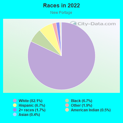
- 4,33282.1%White
- 3556.7%Black
- 3536.7%Hispanic or Latino
- 981.9%Some other race
- 891.7%Two or more races
- 240.5%American Indian
- 230.4%Asian
Median household income in 2022:
| New Portage: | $60,822 |
| Barberton: | $49,289 |
Distribution of median household income
![Distribution of median household income]()
- 72Less than $10,000
- 199$10,000 to $19,999
- 412$20,000 to $29,999
- 353$30,000 to $39,999
- 201$40,000 to $49,999
- 233$50,000 to $59,999
- 331$60,000 to $74,999
- 263$75,000 to $99,999
- 175$100,000 to $124,999
- 87$125,000 to $149,999
- 71$150,000 to $199,999
- 110$200,000 or more

Distribution of owner-occupied house/condo value
![Distribution of owner-occupied house/condo value]()
- 460Less than $50,000
- 1,161$50,000 to $99,999
- 486$100,000 to $149,999
- 169$150,000 to $199,999
- 28$200,000 to $249,999
- 41$250,000 to $299,999
- 148$300,000 to $399,999
- 29$400,000 to $499,999
- 11$500,000 to $749,999

Distribution of rent paid by renters
![Distribution of rent paid by renters]()
- 68Less than $100
- 122$100 to $199
- 195$200 to $299
- 249$300 to $399
- 260$400 to $499
- 343$500 to $599
- 261$600 to $699
- 232$700 to $799
- 122$800 to $899
- 95$900 to $999
- 15$1,000 to $1,249
- 6$1,250 to $1,499
- 46$2,000 or more

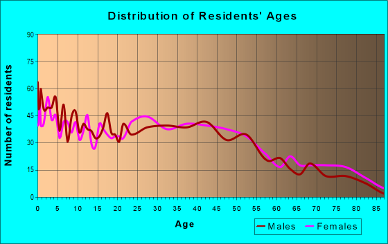
| Males: | 2,271 |
| Females: | 2,640 |
Males:
| This neighborhood: | 38.2 years |
| Whole city: | 39.3 years |
| This neighborhood: | 42.9 years |
| Whole city: | 41.6 years |
Average household size:
| New Portage: | 4.6 people |
| Barberton: | 2.3 people |
Percentage of family households:
| New Portage: | 43.0% |
| Barberton: | 40.8% |
| Here: | 45.2% |
| Barberton: | 35.4% |
Percentage of married-couple families with children (among all households):
| New Portage: | 28.9% |
| Barberton: | 23.2% |
Percentage of single-mother households (among all households):
| New Portage: | 12.7% |
| Barberton: | 17.5% |
Percentage of never married males 15 years old and over:
Percentage of never married females 15 years old and over:
| New Portage: | 18.5% |
| Barberton: | 17.9% |
Percentage of never married females 15 years old and over:
| New Portage: | 14.5% |
| city: | 14.9% |
Percentage of people that speak English not well or not at all:
| New Portage: | 0.6% |
| Barberton: | 0.7% |
Percentage of people born in this state:
Percentage of people born in another U.S. state:
Percentage of native residents but born outside the U.S.:
Percentage of foreign born residents:
| Here: | 86.1% |
| Barberton: | 84.2% |
Percentage of people born in another U.S. state:
| New Portage: | 12.2% |
| Barberton: | 13.9% |
Percentage of native residents but born outside the U.S.:
| Here: | 0.2% |
| city: | 0.5% |
Percentage of foreign born residents:
| Here: | 1.7% |
| Barberton: | 1.4% |
Owner-occupied
Renter-occupied


- Rooms in owner-occupied houses and condos in New Portage
- 01 room
- 92 rooms
- 103 rooms
- 744 rooms
- 3055 rooms
- 4856 rooms
- 2847 rooms
- 1208 rooms
- 899+ rooms
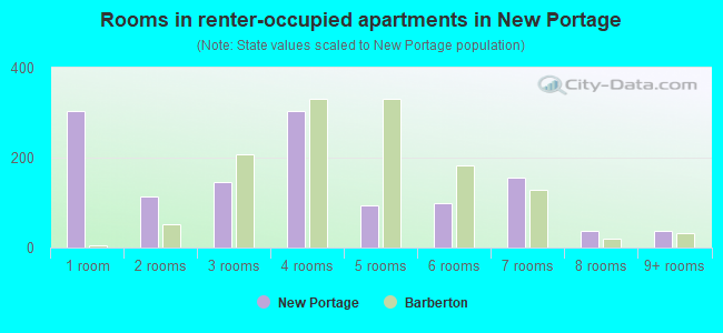
- Rooms in renter-occupied apartments in New Portage
- 3041 room
- 1132 rooms
- 1463 rooms
- 3044 rooms
- 955 rooms
- 1006 rooms
- 1557 rooms
- 368 rooms
- 389+ rooms
Owner-occupied
Renter-occupied
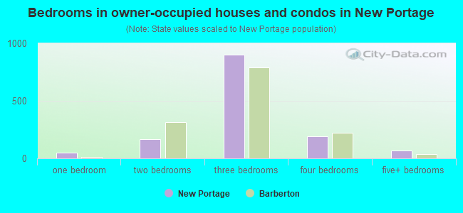
- Bedrooms in owner-occupied houses and condos in New Portage
- 0no bedroom
- 511 bedroom
- 1692 bedrooms
- 9003 bedrooms
- 1924 bedrooms
- 685+ bedrooms
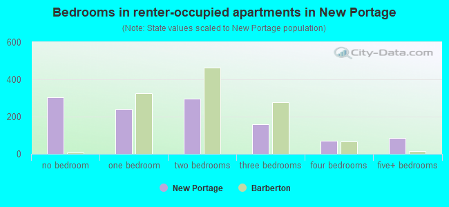
- Bedrooms in renter-occupied apartments in New Portage
- 304no bedroom
- 2401 bedroom
- 2972 bedrooms
- 1593 bedrooms
- 694 bedrooms
- 855+ bedrooms
Average number of cars or other vehicles available in houses/condos:
Average number of cars or other vehicles available in apartments:
| This neighborhood: | 1.9 |
| Barberton: | 1.8 |
Average number of cars or other vehicles available in apartments:
| Here: | 1.4 |
| city: | 1.2 |
Percentage of units with a mortgage:
| New Portage: | 55.4% |
| Barberton: | 60.5% |
Average estimated value of detached houses in 2022 (85.0% of all units):
| New Portage: | $124,542 |
| Ohio: | $254,366 |
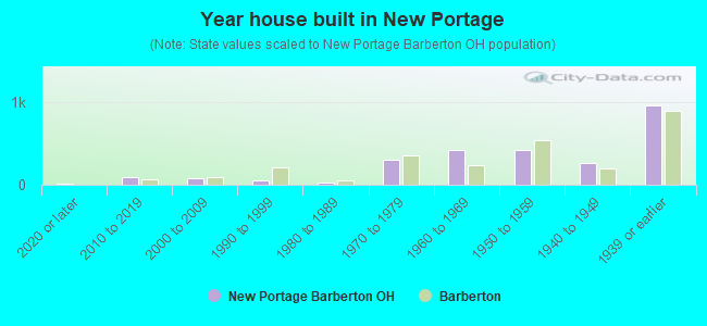
- Year house built in New Portage
- 192020 or later
- 872010 to 2019
- 752000 to 2009
- 501990 to 1999
- 301980 to 1989
- 3051970 to 1979
- 4141960 to 1969
- 4211950 to 1959
- 2691940 to 1949
- 9541939 or earlier
City-data.com crime index for city in 2020 (higher means more crime):
| City: | 231.1 |
| U.S. average: | 219.5 |
Travel time to work (commute)
![Travel time to work (commute)]()
- 110Less than 5 minutes
- 4135 to 9 minutes
- 22610 to 14 minutes
- 27215 to 19 minutes
- 37920 to 24 minutes
- 13925 to 29 minutes
- 17430 to 34 minutes
- 2435 to 39 minutes
- 4640 to 44 minutes
- 11645 to 59 minutes
- 2860 to 89 minutes
- 4090 or more minutes

Means of transportation to work
![Means of transportation to work]()
- 86.5%1,872Drove a car alone
- 8.3%179Carpooled
- 0.0%1Bus
- 5.7%124Taxi
- 1.6%34Motorcycle
- 3.6%77Walked
- 3.8%82Other means
- 5.6%121Worked at home

Time leaving home to go to work
![Time leaving home to go to work]()
- 12112:00 a.m. to 4:59 a.m.
- 285:00 a.m. to 5:29 a.m.
- 945:30 a.m. to 5:59 a.m.
- 1206:00 a.m. to 6:29 a.m.
- 2546:30 a.m. to 6:59 a.m.
- 3437:00 a.m. to 7:29 a.m.
- 1707:30 a.m. to 7:59 a.m.
- 1518:00 a.m. to 8:29 a.m.
- 598:30 a.m. to 8:59 a.m.
- 1449:00 a.m. to 9:59 a.m.
- 3610:00 a.m. to 10:59 a.m.
- 3811:00 a.m. to 11:59 a.m.
- 19012:00 p.m. to 3:59 p.m.
- 2164:00 p.m. to 11:59 p.m.

Occupations of males:
- Percentage of males in management occupations (except farmers):
Here: 6.1% city: 7.6%
- Percentage of males in business and financial operations occupations:
Here: 4.8% city: 4.1%
- Percentage of males in computer and mathematical occupations:
Here: 3.2% city: 3.3%
- Percentage of males in architecture and engineering occupations:
Here: 2.4% city: 1.5%
- Percentage of males in community and social services occupations:
Here: 3.2% city: 0.6%
- Percentage of males in arts, design, entertainment, sports, and media occupations:
Here: 1.4% city: 2.6%
- Percentage of males in healthcare practitioners and technical occupations:
Here: 2.9% city: 2.4%
- Percentage of males in service occupations:
Here: 15.4% city: 11.8%
- Percentage of males in sales and office occupations:
Here: 8.4% city: 17.2%
- Percentage of males in construction, extraction, and maintenance occupations:
Here: 11.3% city: 10.2%
- Percentage of males in production occupations:
Here: 9.4% city: 15.5%
- Percentage of males in transportation occupations:
Here: 9.0% city: 5.4%
- Percentage of males in material moving occupations:
Here: 9.2% city: 7.3%
Occupations of females:
- Percentage of females in management occupations (except farmers):
Here: 5.2% city: 5.1%
- Percentage of females in business and financial operations occupations:
Here: 5.0% city: 4.9%
- Percentage of females in computer and mathematical occupations:
Here: 1.2% city: 0.3%
- Percentage of females in community and social services occupations:
Here: 10.2% city: 2.1%
- Percentage of females in education, training, and library occupations:
Here: 16.0% city: 6.5%
- Percentage of females in healthcare practitioners and technical occupations:
Here: 9.5% city: 9.0%
- Percentage of females in service occupations:
Here: 15.2% city: 23.9%
- Percentage of females in sales and office occupations:
Here: 27.1% city: 35.0%
- Percentage of females in production occupations:
Here: 4.3% city: 5.4%
- Percentage of females in transportation occupations:
Here: 1.3% city: 1.2%
- Percentage of females in material moving occupations:
Here: 3.9% city: 3.6%
Percentage of people 16-64 in Armed Forces:
| New Portage: | 0.5% |
| Barberton: | 0.5% |
Education in this neighborhood (subdivision or community):
- Percentage of people 3 years and older in K-12 schools:
New Portage: 29.2% Barberton: 16.6%
- Percentage of people 3 years and older in undergraduate colleges:
New Portage: 4.3% Barberton: 3.4%
- Percentage of people 3 years and older in grad. or professional schools:
New Portage: 1.9% Barberton: 0.5%
- Percentage of students K-12 enrolled in private schools:
New Portage: 45.7% Barberton: 5.5%
Percentage of population below poverty level:
| New Portage: | 10.8% |
| Barberton: | 16.1% |
Percentage of married-couple families with both working:
| New Portage: | 69.6% |
| Barberton: | 72.5% |
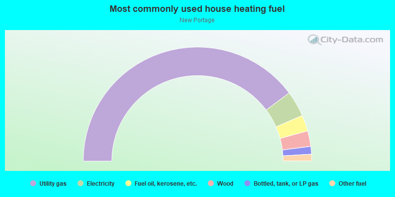
- 79.7%Utility gas
- 7.3%Electricity
- 4.6%Fuel oil, kerosene, etc.
- 4.4%Wood
- 2.2%Bottled, tank, or LP gas
- 1.9%Other fuel
Limited-access highways (interstate or state) in this neighborhood:
US Hwy 224 (I- 76)
Length: 3.20 miles
Directions: E-W, SE-NW
Directions: E-W, SE-NW
Highways in this neighborhood:
W State St (State Rte 619)
Length: 0.83 miles
Directions: N-S, SE-NW, SW-NE
Address range: 44 to 399
Directions: N-S, SE-NW, SW-NE
Address range: 44 to 399
State Rte 619 (E State St)
Length: 0.06 miles
Direction: SE-NW
Address range: 1 to 24
Direction: SE-NW
Address range: 1 to 24
Roads and streets:
N Wooster Rd
Length: 1.69 miles
Directions: E-W, SW-NE
Address range: 492 to 1236
Directions: E-W, SW-NE
Address range: 492 to 1236
Morgan St
Length: 1.10 miles
Direction: E-W
Address range: 100 to 547
Direction: E-W
Address range: 100 to 547
Coventry Rd
Length: 1.08 miles
Direction: SW-NE
Address range: 654 to 1249
Direction: SW-NE
Address range: 654 to 1249
Norton Ave
Length: 1.07 miles
Directions: E-W, SW-NE
Address range: 100 to 532
Directions: E-W, SW-NE
Address range: 100 to 532
W Summit St
Length: 1.02 miles
Directions: E-W, SW-NE
Address range: 14 to 453
Directions: E-W, SW-NE
Address range: 14 to 453
Glenn St
Length: 1.02 miles
Directions: E-W, SE-NW
Address range: 75 to 511
Directions: E-W, SE-NW
Address range: 75 to 511
Barber Rd
Length: 0.92 miles
Direction: N-S
Address range: 3122 to 3499
Direction: N-S
Address range: 3122 to 3499
Orchard Ave
Length: 0.83 miles
Directions: N-S, SW-NE
Address range: 500 to 926
Directions: N-S, SW-NE
Address range: 500 to 926
Newton Ave (Newton St)
Length: 0.80 miles
Directions: E-W, N-S, SE-NW
Address range: 600 to 2006
Directions: E-W, N-S, SE-NW
Address range: 600 to 2006
Hazelwood Ave (Hazelwood St)
Length: 0.71 miles
Directions: E-W, N-S, SE-NW
Address range: 47 to 2999
Directions: E-W, N-S, SE-NW
Address range: 47 to 2999
Romig Ave
Length: 0.62 miles
Direction: SW-NE
Address range: 900 to 1225
Direction: SW-NE
Address range: 900 to 1225
Caroline Ave
Length: 0.56 miles
Direction: E-W
Address range: 1800 to 2021
Direction: E-W
Address range: 1800 to 2021
N Summit St
Length: 0.55 miles
Directions: N-S, SE-NW
Address range: 639 to 999
Directions: N-S, SE-NW
Address range: 639 to 999
Yonker St
Length: 0.55 miles
Directions: E-W, N-S, SE-NW
Address range: 51 to 281
Directions: E-W, N-S, SE-NW
Address range: 51 to 281
Connect Rd
Length: 0.54 miles
Direction: E-W
Address range: 376 to 2099
Direction: E-W
Address range: 376 to 2099
Elmwood St (Elmwood Ave)
Length: 0.53 miles
Directions: E-W, SE-NW
Address range: 1 to 252
Directions: E-W, SE-NW
Address range: 1 to 252
Wesleyan Ave
Length: 0.51 miles
Directions: E-W, N-S, SW-NE
Address range: 500 to 779
Directions: E-W, N-S, SW-NE
Address range: 500 to 779
Hermann St
Length: 0.50 miles
Direction: E-W
Address range: 64 to 284
Direction: E-W
Address range: 64 to 284
Hiram St W
Length: 0.49 miles
Direction: E-W
Address range: 1 to 208
Direction: E-W
Address range: 1 to 208
Evergreen St
Length: 0.47 miles
Direction: E-W
Address range: 80 to 285
Direction: E-W
Address range: 80 to 285
St Clair Ave
Length: 0.44 miles
Directions: N-S, SE-NW
Address range: 654 to 901
Directions: N-S, SE-NW
Address range: 654 to 901
Norwood St
Length: 0.42 miles
Directions: E-W, SE-NW
Address range: 25 to 176
Directions: E-W, SE-NW
Address range: 25 to 176
Madison Ave
Length: 0.41 miles
Directions: N-S, SE-NW
Address range: 600 to 933
Directions: N-S, SE-NW
Address range: 600 to 933
Mitchell St
Length: 0.36 miles
Direction: E-W
Address range: 47 to 206
Direction: E-W
Address range: 47 to 206
Fernwood Ave (Fernwood St)
Length: 0.34 miles
Directions: E-W, SE-NW
Address range: 31 to 184
Directions: E-W, SE-NW
Address range: 31 to 184
Huntsberger Dr (Huntsberger St)
Length: 0.32 miles
Directions: E-W, SE-NW
Address range: 3300 to 3699
Directions: E-W, SE-NW
Address range: 3300 to 3699
N Way St
Length: 0.32 miles
Directions: E-W, N-S, SW-NE
Address range: 619 to 776
Directions: E-W, N-S, SW-NE
Address range: 619 to 776
Lloyd St
Length: 0.31 miles
Directions: N-S, SE-NW
Address range: 444 to 606
Directions: N-S, SE-NW
Address range: 444 to 606
Oakwood St
Length: 0.29 miles
Direction: E-W
Address range: 61 to 199
Direction: E-W
Address range: 61 to 199
W Way St
Length: 0.29 miles
Direction: E-W
Address range: 140 to 259
Direction: E-W
Address range: 140 to 259
Charles Ave
Length: 0.27 miles
Directions: E-W, N-S, SW-NE
Address range: 600 to 747
Directions: E-W, N-S, SW-NE
Address range: 600 to 747
Central Ave
Length: 0.26 miles
Direction: SW-NE
Address range: 1083 to 1215
Direction: SW-NE
Address range: 1083 to 1215
Newell St
Length: 0.24 miles
Direction: N-S
Address range: 369 to 499
Direction: N-S
Address range: 369 to 499
Burt St
Length: 0.24 miles
Directions: N-S, SE-NW, SW-NE
Address range: 551 to 641
Directions: N-S, SE-NW, SW-NE
Address range: 551 to 641
3rd St NW
Length: 0.24 miles
Direction: N-S
Address range: 367 to 499
Direction: N-S
Address range: 367 to 499
St John St
Length: 0.22 miles
Direction: E-W
Address range: 100 to 173
Direction: E-W
Address range: 100 to 173
Summit Rd
Length: 0.22 miles
Directions: N-S, SE-NW
Address range: 4201 to 4399
Directions: N-S, SE-NW
Address range: 4201 to 4399
Erie St
Length: 0.21 miles
Directions: E-W, N-S, SE-NW
Address range: 400 to 499
Directions: E-W, N-S, SE-NW
Address range: 400 to 499
Keller St
Length: 0.21 miles
Directions: E-W, SE-NW
Address range: 550 to 659
Directions: E-W, SE-NW
Address range: 550 to 659
Parkview Ave
Length: 0.19 miles
Direction: N-S
Address range: 500 to 607
Direction: N-S
Address range: 500 to 607
Hiram St E
Length: 0.19 miles
Directions: E-W, SE-NW
Address range: 1 to 99
Directions: E-W, SE-NW
Address range: 1 to 99
Princeton Ave
Length: 0.19 miles
Direction: N-S
Address range: 500 to 599
Direction: N-S
Address range: 500 to 599
Miami Ave
Length: 0.18 miles
Direction: N-S
Address range: 500 to 626
Direction: N-S
Address range: 500 to 626
Young Ave
Length: 0.18 miles
Directions: E-W, N-S, SE-NW, SW-NE
Address range: 941 to 999
Directions: E-W, N-S, SE-NW, SW-NE
Address range: 941 to 999
W Waterloo Rd
Length: 0.18 miles
Directions: E-W, SE-NW
Address range: 1513 to 1599
Directions: E-W, SE-NW
Address range: 1513 to 1599
Horn St
Length: 0.18 miles
Direction: E-W
Address range: 200 to 299
Direction: E-W
Address range: 200 to 299
Paul Pl (Lloyd Ave)
Length: 0.14 miles
Directions: E-W, SE-NW, SW-NE
Address range: 546 to 599
Directions: E-W, SE-NW, SW-NE
Address range: 546 to 599
Swigart St
Length: 0.13 miles
Direction: E-W
Address range: 2 to 49
Direction: E-W
Address range: 2 to 49
Graceland Ave (Graceland St)
Length: 0.13 miles
Direction: N-S
Address range: 700 to 899
Direction: N-S
Address range: 700 to 899
Brady Ave
Length: 0.13 miles
Direction: E-W
Address range: 471 to 521
Direction: E-W
Address range: 471 to 521
Parker Ave
Length: 0.12 miles
Direction: N-S
Address range: 500 to 572
Direction: N-S
Address range: 500 to 572
Harvard Ave
Length: 0.12 miles
Direction: N-S
Address range: 500 to 572
Direction: N-S
Address range: 500 to 572
Yale Ave
Length: 0.12 miles
Direction: N-S
Address range: 500 to 572
Direction: N-S
Address range: 500 to 572
Otterbein Ave
Length: 0.12 miles
Direction: N-S
Address range: 500 to 571
Direction: N-S
Address range: 500 to 571
New St
Length: 0.12 miles
Directions: E-W, SE-NW, SW-NE
Directions: E-W, SE-NW, SW-NE
Ontario St
Length: 0.11 miles
Direction: E-W
Address range: 247 to 283
Direction: E-W
Address range: 247 to 283
Ashland Ct
Length: 0.10 miles
Directions: N-S, SE-NW, SW-NE
Address range: 800 to 853
Directions: N-S, SE-NW, SW-NE
Address range: 800 to 853
Crawford Ave
Length: 0.10 miles
Direction: N-S
Address range: 600 to 657
Direction: N-S
Address range: 600 to 657
Huron St
Length: 0.09 miles
Direction: SW-NE
Address range: 230 to 277
Direction: SW-NE
Address range: 230 to 277
Camp St
Length: 0.09 miles
Direction: SE-NW
Direction: SE-NW
Borden St
Length: 0.08 miles
Direction: SE-NW
Address range: 1 to 54
Direction: SE-NW
Address range: 1 to 54
May St (May Ave)
Length: 0.08 miles
Direction: SE-NW
Address range: 1 to 99
Direction: SE-NW
Address range: 1 to 99
Fairview Ave
Length: 0.07 miles
Direction: SE-NW
Address range: 1 to 204
Direction: SE-NW
Address range: 1 to 204
Audrey St
Length: 0.07 miles
Direction: E-W
Address range: 176 to 220
Direction: E-W
Address range: 176 to 220
Fritz St
Length: 0.07 miles
Directions: E-W, SW-NE
Address range: 113 to 153
Directions: E-W, SW-NE
Address range: 113 to 153
Case Ave
Length: 0.06 miles
Direction: E-W
Address range: 400 to 453
Direction: E-W
Address range: 400 to 453
Beech St
Length: 0.06 miles
Direction: SE-NW
Address range: 100 to 199
Direction: SE-NW
Address range: 100 to 199
Wunderlich Ave
Length: 0.06 miles
Direction: N-S
Address range: 368 to 413
Direction: N-S
Address range: 368 to 413
Dunn St (Dunn Ave)
Length: 0.05 miles
Direction: N-S
Address range: 200 to 252
Direction: N-S
Address range: 200 to 252
Gum St
Length: 0.05 miles
Directions: N-S, SE-NW
Address range: 100 to 142
Directions: N-S, SE-NW
Address range: 100 to 142
Mack St
Length: 0.05 miles
Directions: E-W, SE-NW
Address range: 514 to 555
Directions: E-W, SE-NW
Address range: 514 to 555
Portage St
Length: 0.05 miles
Directions: E-W, SE-NW
Address range: 590 to 618
Directions: E-W, SE-NW
Address range: 590 to 618
Fuller St
Length: 0.04 miles
Direction: E-W
Address range: 500 to 519
Direction: E-W
Address range: 500 to 519
High St
Length: 0.04 miles
Directions: N-S, SW-NE
Directions: N-S, SW-NE
Railroad features:
Csx RR
Length: 1.37 miles
Direction: SW-NE
Direction: SW-NE
Akron & Barberton Cluster RR
Length: 1.10 miles
Directions: E-W, SW-NE
Directions: E-W, SW-NE
Other features:
Ohio Cnl
Length: 0.46 miles
Direction: SW-NE
Direction: SW-NE
Other features:
Tuscarawas Riv
Length: 0.44 miles
Direction: SW-NE
Direction: SW-NE
Wolf Crk
Length: 0.38 miles
Direction: SW-NE
Direction: SW-NE
Mud Run
Length: 0.23 miles
Directions: N-S, SW-NE
Directions: N-S, SW-NE