Los Altos neighborhood in Long Beach, California (CA), 90815 detailed profile
Settings
X


Business Search - 14 Million verified businesses
Area: 2.447 square miles
Population: 18,894
Population density:
| Los Altos: | 7,721 people per square mile |
| Long Beach: | 8,948 people per square mile |

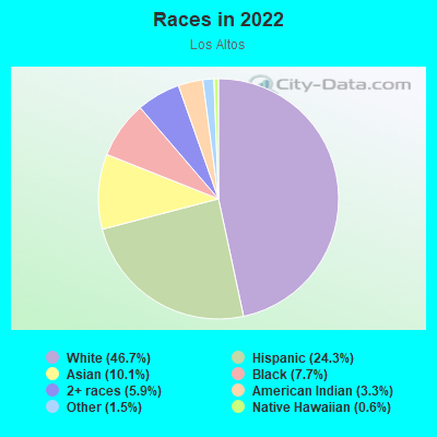
- 9,42246.7%White
- 4,90224.3%Hispanic or Latino
- 2,04010.1%Asian
- 1,5457.7%Black
- 1,1815.9%Two or more races
- 6663.3%American Indian
- 3091.5%Some other race
- 1210.6%Native Hawaiian and Other
Pacific Islander
Median household income in 2022:
| Los Altos: | $111,257 |
| Long Beach: | $80,493 |
Distribution of median household income
![Distribution of median household income]()
- 457Less than $10,000
- 523$10,000 to $19,999
- 524$20,000 to $29,999
- 386$30,000 to $39,999
- 536$40,000 to $49,999
- 530$50,000 to $59,999
- 619$60,000 to $74,999
- 673$75,000 to $99,999
- 906$100,000 to $124,999
- 806$125,000 to $149,999
- 927$150,000 to $199,999
- 1,611$200,000 or more

Distribution of owner-occupied house/condo value
![Distribution of owner-occupied house/condo value]()
- 262Less than $50,000
- 610$50,000 to $99,999
- 325$100,000 to $149,999
- 28$150,000 to $199,999
- 12$200,000 to $249,999
- 112$250,000 to $299,999
- 1,169$300,000 to $399,999
- 264$400,000 to $499,999
- 1,289$500,000 to $749,999
- 2,645$750,000 to $999,999
- 1,385$1,000,000 or more

Distribution of rent paid by renters
![Distribution of rent paid by renters]()
- 303$200 to $299
- 39$300 to $399
- 77$500 to $599
- 127$700 to $799
- 146$800 to $899
- 72$900 to $999
- 608$1,000 to $1,249
- 603$1,250 to $1,499
- 817$1,500 to $1,999
- 2,684$2,000 or more

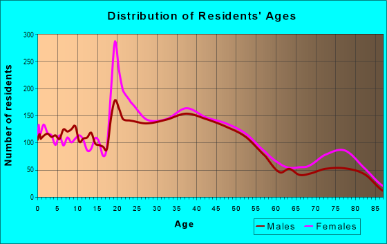
| Males: | 9,558 |
| Females: | 9,335 |
Males:
| This neighborhood: | 38.8 years |
| Whole city: | 35.5 years |
| This neighborhood: | 41.2 years |
| Whole city: | 37.7 years |
Average household size:
| Los Altos: | 3.5 people |
| Long Beach: | 2.6 people |
Percentage of family households:
| Los Altos: | 52.0% |
| Long Beach: | 43.1% |
| Here: | 53.5% |
| Long Beach: | 35.6% |
Percentage of married-couple families with children (among all households):
| Los Altos: | 29.7% |
| Long Beach: | 21.4% |
Percentage of single-mother households (among all households):
| Los Altos: | 9.3% |
| Long Beach: | 12.6% |
Percentage of never married males 15 years old and over:
Percentage of never married females 15 years old and over:
| Los Altos: | 18.8% |
| Long Beach: | 24.6% |
Percentage of never married females 15 years old and over:
| Los Altos: | 18.8% |
| city: | 23.9% |
Percentage of people that speak English not well or not at all:
| Los Altos: | 2.0% |
| Long Beach: | 7.4% |
Percentage of people born in this state:
Percentage of people born in another U.S. state:
Percentage of native residents but born outside the U.S.:
Percentage of foreign born residents:
| Here: | 68.4% |
| Long Beach: | 62.4% |
Percentage of people born in another U.S. state:
| Los Altos: | 17.2% |
| Long Beach: | 12.5% |
Percentage of native residents but born outside the U.S.:
| Here: | 1.3% |
| city: | 1.4% |
Percentage of foreign born residents:
| Here: | 13.1% |
| Long Beach: | 23.7% |
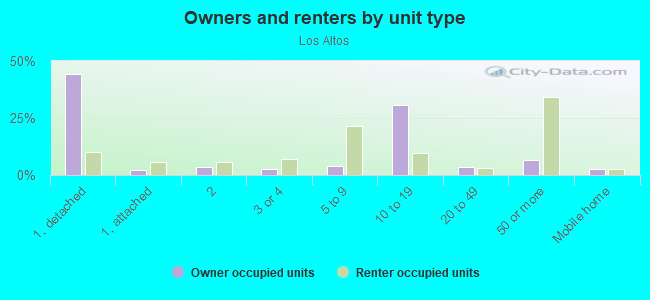
Owner-occupied
Renter-occupied

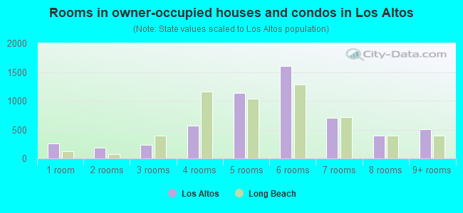
- Rooms in owner-occupied houses and condos in Los Altos
- 2571 room
- 1802 rooms
- 2333 rooms
- 5704 rooms
- 1,1345 rooms
- 1,5996 rooms
- 7077 rooms
- 3968 rooms
- 5119+ rooms
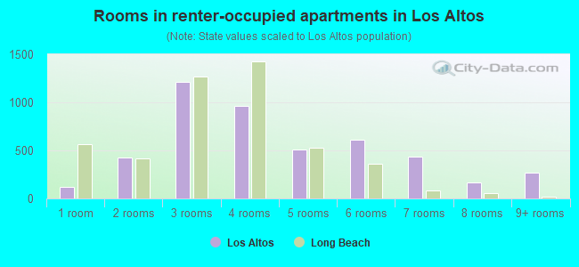
- Rooms in renter-occupied apartments in Los Altos
- 1161 room
- 4282 rooms
- 1,2093 rooms
- 9594 rooms
- 5135 rooms
- 6136 rooms
- 4347 rooms
- 1708 rooms
- 2719+ rooms
Owner-occupied
Renter-occupied
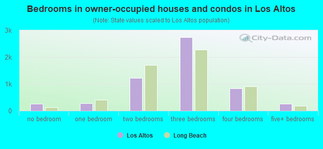
- Bedrooms in owner-occupied houses and condos in Los Altos
- 257no bedroom
- 2691 bedroom
- 1,2172 bedrooms
- 2,7463 bedrooms
- 8394 bedrooms
- 2595+ bedrooms
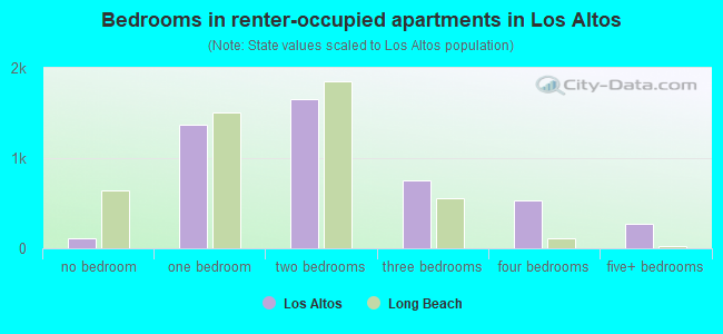
- Bedrooms in renter-occupied apartments in Los Altos
- 116no bedroom
- 1,3741 bedroom
- 1,6492 bedrooms
- 7533 bedrooms
- 5274 bedrooms
- 2775+ bedrooms
Average number of cars or other vehicles available in houses/condos:
Average number of cars or other vehicles available in apartments:
| This neighborhood: | |
| Long Beach: |
Average number of cars or other vehicles available in apartments:
| Here: | 2.2 |
| city: | 1.4 |
Percentage of units with a mortgage:
| Los Altos: | 74.1% |
| Long Beach: | 70.2% |
Average estimated value of detached houses in 2022 (78.9% of all units):
| Los Altos: | $448,713 |
| Long Beach: | $840,606 |
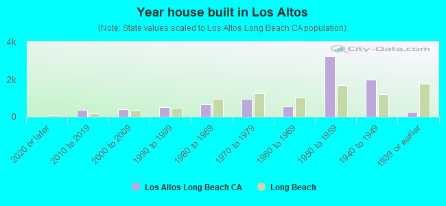
- Year house built in Los Altos
- 02020 or later
- 3752010 to 2019
- 4092000 to 2009
- 5221990 to 1999
- 6571980 to 1989
- 9381970 to 1979
- 5671960 to 1969
- 3,2361950 to 1959
- 1,9951940 to 1949
- 2701939 or earlier
City-data.com crime index for city in 2020 (higher means more crime):
| City: | 312.7 |
| U.S. average: | 219.5 |
Travel time to work (commute)
![Travel time to work (commute)]()
- 106Less than 5 minutes
- 4395 to 9 minutes
- 80010 to 14 minutes
- 87515 to 19 minutes
- 1,20120 to 24 minutes
- 34825 to 29 minutes
- 1,48730 to 34 minutes
- 24435 to 39 minutes
- 27540 to 44 minutes
- 99445 to 59 minutes
- 56360 to 89 minutes
- 18790 or more minutes

Means of transportation to work
![Means of transportation to work]()
- 76.8%7,239Drove a car alone
- 6.8%643Carpooled
- 3.6%339Bus
- 2.4%225Subway or elevated rail
- 2.2%205Long-distance train or commuter rail
- 3.8%361Light rail, streetcar or trolley
- 1.3%127Taxi
- 3.2%299Motorcycle
- 2.9%273Bicycle
- 2.9%275Walked
- 4.9%458Other means
- 14.0%1,321Worked at home

Time leaving home to go to work
![Time leaving home to go to work]()
- 30712:00 a.m. to 4:59 a.m.
- 1735:00 a.m. to 5:29 a.m.
- 2615:30 a.m. to 5:59 a.m.
- 6366:00 a.m. to 6:29 a.m.
- 5886:30 a.m. to 6:59 a.m.
- 1,3427:00 a.m. to 7:29 a.m.
- 5937:30 a.m. to 7:59 a.m.
- 1,6208:00 a.m. to 8:29 a.m.
- 4478:30 a.m. to 8:59 a.m.
- 4349:00 a.m. to 9:59 a.m.
- 15510:00 a.m. to 10:59 a.m.
- 13011:00 a.m. to 11:59 a.m.
- 38012:00 p.m. to 3:59 p.m.
- 2344:00 p.m. to 11:59 p.m.

Occupations of males:
- Percentage of males in management occupations (except farmers):
Here: 14.1% city: 10.3%
- Percentage of males in business and financial operations occupations:
Here: 9.0% city: 5.1%
- Percentage of males in computer and mathematical occupations:
Here: 4.0% city: 4.1%
- Percentage of males in architecture and engineering occupations:
Here: 4.6% city: 3.2%
- Percentage of males in community and social services occupations:
Here: 2.7% city: 1.0%
- Percentage of males in legal occupations:
Here: 7.5% city: 1.1%
- Percentage of males in education, training, and library occupations:
Here: 4.7% city: 3.8%
- Percentage of males in arts, design, entertainment, sports, and media occupations:
Here: 5.4% city: 4.0%
- Percentage of males in healthcare practitioners and technical occupations:
Here: 2.5% city: 3.0%
- Percentage of males in service occupations:
Here: 7.7% city: 16.3%
- Percentage of males in sales and office occupations:
Here: 15.0% city: 15.7%
- Percentage of males in construction, extraction, and maintenance occupations:
Here: 6.1% city: 7.8%
- Percentage of males in production occupations:
Here: 4.9% city: 6.4%
- Percentage of males in transportation occupations:
Here: 4.9% city: 6.8%
- Percentage of males in material moving occupations:
Here: 3.0% city: 5.9%
Occupations of females:
- Percentage of females in management occupations (except farmers):
Here: 8.9% city: 9.5%
- Percentage of females in business and financial operations occupations:
Here: 16.2% city: 6.5%
- Percentage of females in computer and mathematical occupations:
Here: 1.0% city: 1.7%
- Percentage of females in architecture and engineering occupations:
Here: 1.8% city: 1.0%
- Percentage of females in life, physical, and social science occupations:
Here: 1.5% city: 1.0%
- Percentage of females in community and social services occupations:
Here: 3.5% city: 3.3%
- Percentage of females in education, training, and library occupations:
Here: 12.3% city: 8.3%
- Percentage of females in arts, design, entertainment, sports, and media occupations:
Here: 7.8% city: 3.2%
- Percentage of females in healthcare practitioners and technical occupations:
Here: 9.5% city: 7.4%
- Percentage of females in service occupations:
Here: 12.4% city: 21.6%
- Percentage of females in sales and office occupations:
Here: 20.5% city: 27.8%
- Percentage of females in transportation occupations:
Here: 1.7% city: 1.4%
Percentage of people 16-64 in Armed Forces:
| Los Altos: | 0.1% |
| Long Beach: | 0.2% |
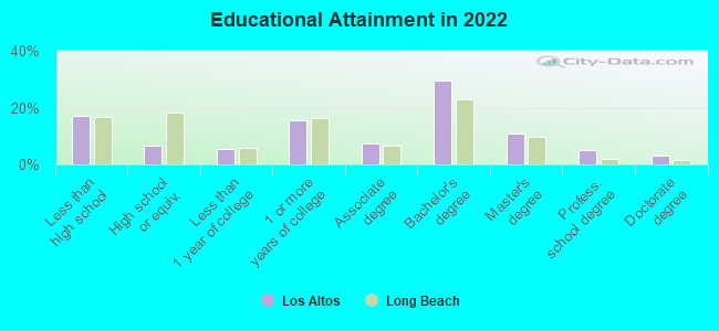
Education in this neighborhood (subdivision or community):
- Percentage of people 3 years and older in K-12 schools:
Los Altos: 22.2% Long Beach: 15.8%
- Percentage of people 3 years and older in undergraduate colleges:
Los Altos: 11.8% Long Beach: 7.2%
- Percentage of people 3 years and older in grad. or professional schools:
Los Altos: 3.9% Long Beach: 1.4%
- Percentage of students K-12 enrolled in private schools:
Los Altos: 50.5% Long Beach: 4.5%
Percentage of population below poverty level:
| Los Altos: | 10.4% |
| Long Beach: | 13.8% |
Percentage of married-couple families with both working:
| Los Altos: | 100.4% |
| Long Beach: | 68.2% |
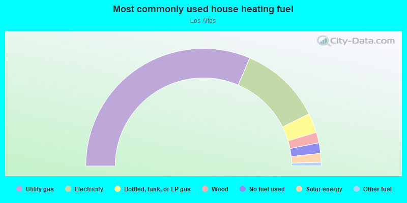
- 62.9%Utility gas
- 22.5%Electricity
- 5.4%Bottled, tank, or LP gas
- 2.9%Wood
- 2.9%No fuel used
- 2.4%Solar energy
- 1.0%Other fuel
Limited-access highways (interstate or state) in this neighborhood:
I- 405 (San Diego Fwy)
Length: 0.75 miles
Directions: E-W, SE-NW
Directions: E-W, SE-NW
Highways in this neighborhood:
N Lakewood Blvd (State Rte 19)
Length: 0.56 miles
Direction: N-S
Address range: 1900 to 2299
Direction: N-S
Address range: 1900 to 2299
Roads and streets:
Stearns St
Length: 2.02 miles
Direction: E-W
Address range: 5026 to 6438
Direction: E-W
Address range: 5026 to 6438
E 23rd St
Length: 1.72 miles
Directions: E-W, SW-NE
Address range: 3800 to 6199
Directions: E-W, SW-NE
Address range: 3800 to 6199
E Los Santos Dr
Length: 1.39 miles
Directions: E-W, N-S, SE-NW, SW-NE
Address range: 5600 to 6599
Directions: E-W, N-S, SE-NW, SW-NE
Address range: 5600 to 6599
E Los Coyotes Diagonal
Length: 1.33 miles
Directions: E-W, SW-NE
Address range: 4500 to 5599
Directions: E-W, SW-NE
Address range: 4500 to 5599
Clark Ave
Length: 1.27 miles
Directions: E-W, N-S
Address range: 1416 to 5199
Directions: E-W, N-S
Address range: 1416 to 5199
E Vernon St
Length: 1.22 miles
Directions: E-W, N-S, SE-NW, SW-NE
Address range: 3950 to 5799
Directions: E-W, N-S, SE-NW, SW-NE
Address range: 3950 to 5799
E Atherton St
Length: 1.10 miles
Directions: E-W, SE-NW
Address range: 4500 to 6899
Directions: E-W, SE-NW
Address range: 4500 to 6899
E Marita St
Length: 1.07 miles
Direction: E-W
Address range: 5800 to 6599
Direction: E-W
Address range: 5800 to 6599
E Fairbrook St
Length: 1.00 miles
Directions: E-W, SE-NW
Address range: 5200 to 6499
Directions: E-W, SE-NW
Address range: 5200 to 6499
Woodruff Ave
Length: 0.98 miles
Directions: E-W, N-S, SE-NW
Directions: E-W, N-S, SE-NW
E Stearns St
Length: 0.97 miles
Direction: E-W
Address range: 3760 to 5099
Direction: E-W
Address range: 3760 to 5099
E Garford St
Length: 0.88 miles
Directions: E-W, SE-NW
Address range: 4800 to 5999
Directions: E-W, SE-NW
Address range: 4800 to 5999
San Anseline Ave
Length: 0.78 miles
Directions: N-S, SE-NW, SW-NE
Address range: 1900 to 2499
Directions: N-S, SE-NW, SW-NE
Address range: 1900 to 2499
E Daggett St
Length: 0.73 miles
Directions: E-W, N-S, SW-NE
Address range: 5200 to 5699
Directions: E-W, N-S, SW-NE
Address range: 5200 to 5699
N Bellflower Blvd
Length: 0.73 miles
Direction: N-S
Address range: 2000 to 2499
Direction: N-S
Address range: 2000 to 2499
N Ocana Ave
Length: 0.71 miles
Directions: N-S, SE-NW
Address range: 2000 to 2499
Directions: N-S, SE-NW
Address range: 2000 to 2499
N Park Ave
Length: 0.71 miles
Directions: N-S, SE-NW, SW-NE
Address range: 1535 to 2513
Directions: N-S, SE-NW, SW-NE
Address range: 1535 to 2513
E Los Arcos St
Length: 0.70 miles
Directions: E-W, SE-NW, SW-NE
Address range: 5600 to 6199
Directions: E-W, SE-NW, SW-NE
Address range: 5600 to 6199
Palo Verde Ave
Length: 0.69 miles
Direction: N-S
Address range: 1600 to 2250
Direction: N-S
Address range: 1600 to 2250
Ximeno Ave
Length: 0.65 miles
Directions: N-S, SE-NW
Address range: 1800 to 2599
Directions: N-S, SE-NW
Address range: 1800 to 2599
Stearnlee Ave
Length: 0.64 miles
Directions: E-W, N-S, SE-NW, SW-NE
Address range: 2100 to 2499
Directions: E-W, N-S, SE-NW, SW-NE
Address range: 2100 to 2499
Vuelte Grande Ave
Length: 0.62 miles
Directions: N-S, SE-NW, SW-NE
Address range: 1300 to 1999
Directions: N-S, SE-NW, SW-NE
Address range: 1300 to 1999
Fanwood Ave
Length: 0.62 miles
Direction: N-S
Address range: 1900 to 2499
Direction: N-S
Address range: 1900 to 2499
N San Vicente Ave
Length: 0.62 miles
Direction: N-S
Address range: 1900 to 2399
Direction: N-S
Address range: 1900 to 2399
Albury Ave
Length: 0.62 miles
Directions: N-S, SE-NW
Address range: 2000 to 2499
Directions: N-S, SE-NW
Address range: 2000 to 2499
Tulane Ave
Length: 0.57 miles
Directions: N-S, SE-NW, SW-NE
Address range: 2100 to 2399
Directions: N-S, SE-NW, SW-NE
Address range: 2100 to 2399
McNab Ave
Length: 0.57 miles
Direction: N-S
Address range: 1900 to 2299
Direction: N-S
Address range: 1900 to 2299
E el Paseo St
Length: 0.56 miles
Directions: E-W, SE-NW
Address range: 5600 to 6499
Directions: E-W, SE-NW
Address range: 5600 to 6499
Iroquois Ave
Length: 0.56 miles
Directions: N-S, SE-NW
Address range: 1350 to 2099
Directions: N-S, SE-NW
Address range: 1350 to 2099
Hackett Ave
Length: 0.55 miles
Direction: N-S
Address range: 1200 to 1899
Direction: N-S
Address range: 1200 to 1899
Montair Ave
Length: 0.54 miles
Directions: N-S, SE-NW, SW-NE
Address range: 2100 to 2499
Directions: N-S, SE-NW, SW-NE
Address range: 2100 to 2499
Stanbridge Ave
Length: 0.53 miles
Directions: N-S, SE-NW
Address range: 2100 to 2399
Directions: N-S, SE-NW
Address range: 2100 to 2399
Josie Ave
Length: 0.52 miles
Directions: N-S, SE-NW
Address range: 1300 to 2099
Directions: N-S, SE-NW
Address range: 1300 to 2099
Faust Ave
Length: 0.51 miles
Direction: N-S
Address range: 1900 to 2399
Direction: N-S
Address range: 1900 to 2399
Belmont Ave
Length: 0.49 miles
Direction: N-S
Address range: 2100 to 2555
Direction: N-S
Address range: 2100 to 2555
E Eagle St
Length: 0.48 miles
Directions: E-W, SW-NE
Address range: 5100 to 5399
Directions: E-W, SW-NE
Address range: 5100 to 5399
Knoxville Ave
Length: 0.48 miles
Directions: N-S, SE-NW
Address range: 1200 to 2099
Directions: N-S, SE-NW
Address range: 1200 to 2099
N Termino Ave
Length: 0.46 miles
Direction: N-S
Address range: 2200 to 2599
Direction: N-S
Address range: 2200 to 2599
Gondar Ave
Length: 0.45 miles
Directions: N-S, SW-NE
Address range: 2000 to 2299
Directions: N-S, SW-NE
Address range: 2000 to 2299
N Pepperwood Ave
Length: 0.45 miles
Directions: E-W, N-S, SE-NW, SW-NE
Address range: 2200 to 2511
Directions: E-W, N-S, SE-NW, SW-NE
Address range: 2200 to 2511
Senasac Ave
Length: 0.45 miles
Direction: N-S
Address range: 1900 to 2299
Direction: N-S
Address range: 1900 to 2299
N Roswell Ave
Length: 0.45 miles
Directions: E-W, N-S, SE-NW, SW-NE
Address range: 2200 to 2499
Directions: E-W, N-S, SE-NW, SW-NE
Address range: 2200 to 2499
Argonne Ave
Length: 0.44 miles
Direction: N-S
Address range: 2200 to 2499
Direction: N-S
Address range: 2200 to 2499
N Granada Ave
Length: 0.44 miles
Directions: N-S, SE-NW
Address range: 2200 to 2499
Directions: N-S, SE-NW
Address range: 2200 to 2499
N Radnor Ave
Length: 0.42 miles
Directions: E-W, N-S, SE-NW
Address range: 2000 to 2299
Directions: E-W, N-S, SE-NW
Address range: 2000 to 2299
Carfax Ave
Length: 0.42 miles
Directions: E-W, N-S, SE-NW, SW-NE
Address range: 1853 to 2349
Directions: E-W, N-S, SE-NW, SW-NE
Address range: 1853 to 2349
N Studebaker Rd
Length: 0.42 miles
Directions: N-S, SW-NE
Address range: 1302 to 1733
Directions: N-S, SW-NE
Address range: 1302 to 1733
N Marwick Ave
Length: 0.42 miles
Directions: N-S, SE-NW
Address range: 2200 to 2499
Directions: N-S, SE-NW
Address range: 2200 to 2499
N Lomina Ave
Length: 0.40 miles
Directions: N-S, SE-NW, SW-NE
Address range: 2000 to 2299
Directions: N-S, SE-NW, SW-NE
Address range: 2000 to 2299
Miramar Ave
Length: 0.40 miles
Directions: E-W, N-S, SE-NW, SW-NE
Address range: 2200 to 2599
Directions: E-W, N-S, SE-NW, SW-NE
Address range: 2200 to 2599
E Abbeyfield St
Length: 0.40 miles
Directions: E-W, SW-NE
Address range: 5300 to 5499
Directions: E-W, SW-NE
Address range: 5300 to 5499
Conquista Ave
Length: 0.39 miles
Directions: N-S, SE-NW, SW-NE
Address range: 1900 to 2299
Directions: N-S, SE-NW, SW-NE
Address range: 1900 to 2299
Petaluma Ave
Length: 0.39 miles
Directions: E-W, N-S, SE-NW, SW-NE
Address range: 1600 to 1899
Directions: E-W, N-S, SE-NW, SW-NE
Address range: 1600 to 1899
N Hidden Ln
Length: 0.39 miles
Directions: N-S, SE-NW
Address range: 1900 to 2099
Directions: N-S, SE-NW
Address range: 1900 to 2099
E Burnett St
Length: 0.38 miles
Directions: E-W, SW-NE
Address range: 4500 to 5299
Directions: E-W, SW-NE
Address range: 4500 to 5299
Tevis Ave
Length: 0.37 miles
Directions: E-W, N-S, SW-NE
Address range: 2000 to 2299
Directions: E-W, N-S, SW-NE
Address range: 2000 to 2299
Snowden Ave
Length: 0.35 miles
Directions: N-S, SW-NE
Address range: 1900 to 2399
Directions: N-S, SW-NE
Address range: 1900 to 2399
N Rutgers Ave
Length: 0.35 miles
Directions: N-S, SE-NW
Address range: 2000 to 2399
Directions: N-S, SE-NW
Address range: 2000 to 2399
N Heather Ave
Length: 0.34 miles
Directions: E-W, SE-NW
Address range: 2300 to 2499
Directions: E-W, SE-NW
Address range: 2300 to 2499
N Greenbrier Rd
Length: 0.33 miles
Direction: N-S
Address range: 1900 to 2199
Direction: N-S
Address range: 1900 to 2199
E Calderwood St
Length: 0.33 miles
Directions: E-W, SW-NE
Address range: 5100 to 5399
Directions: E-W, SW-NE
Address range: 5100 to 5399
E Bayard St
Length: 0.32 miles
Directions: E-W, SE-NW
Address range: 5100 to 6499
Directions: E-W, SE-NW
Address range: 5100 to 6499
Fidler Ave
Length: 0.32 miles
Directions: E-W, N-S, SW-NE
Address range: 2000 to 2199
Directions: E-W, N-S, SW-NE
Address range: 2000 to 2199
E Hill St
Length: 0.31 miles
Direction: E-W
Address range: 5000 to 5499
Direction: E-W
Address range: 5000 to 5499
E de Ora Way
Length: 0.30 miles
Directions: E-W, N-S, SW-NE
Address range: 4300 to 4599
Directions: E-W, N-S, SW-NE
Address range: 4300 to 4599
Marber Ave
Length: 0.30 miles
Direction: N-S
Address range: 2000 to 2499
Direction: N-S
Address range: 2000 to 2499
E Ferro St
Length: 0.30 miles
Directions: E-W, SE-NW, SW-NE
Address range: 4900 to 4999
Directions: E-W, SE-NW, SW-NE
Address range: 4900 to 4999
Chatwin Ave
Length: 0.29 miles
Directions: N-S, SE-NW
Address range: 1831 to 2099
Directions: N-S, SE-NW
Address range: 1831 to 2099
E Patero Way
Length: 0.28 miles
Directions: E-W, N-S, SE-NW, SW-NE
Address range: 4000 to 4399
Directions: E-W, N-S, SE-NW, SW-NE
Address range: 4000 to 4399
E Galeano St
Length: 0.28 miles
Directions: E-W, SE-NW
Address range: 4300 to 4599
Directions: E-W, SE-NW
Address range: 4300 to 4599
E Anaheim Rd
Length: 0.27 miles
Direction: E-W
Address range: 6416 to 6619
Direction: E-W
Address range: 6416 to 6619
E Driscoll St
Length: 0.27 miles
Directions: E-W, SE-NW
Address range: 6500 to 6799
Directions: E-W, SE-NW
Address range: 6500 to 6799
N Litchfield Ave
Length: 0.26 miles
Directions: E-W, SE-NW
Address range: 1900 to 2099
Directions: E-W, SE-NW
Address range: 1900 to 2099
S Charlemagne Ave
Length: 0.25 miles
Directions: E-W, N-S, SE-NW
Address range: 2300 to 2499
Directions: E-W, N-S, SE-NW
Address range: 2300 to 2499
Charlemagne Ave
Length: 0.25 miles
Directions: N-S, SE-NW
Address range: 2000 to 2199
Directions: N-S, SE-NW
Address range: 2000 to 2199
Grand Ave
Length: 0.25 miles
Direction: N-S
Address range: 2200 to 2299
Direction: N-S
Address range: 2200 to 2299
E Britton Dr
Length: 0.25 miles
Directions: E-W, SE-NW
Address range: 5500 to 5699
Directions: E-W, SE-NW
Address range: 5500 to 5699
E la Cara St
Length: 0.25 miles
Directions: E-W, SE-NW
Address range: 4300 to 4699
Directions: E-W, SE-NW
Address range: 4300 to 4699
E Rendina St
Length: 0.25 miles
Direction: E-W
Address range: 6400 to 6599
Direction: E-W
Address range: 6400 to 6599
Nipomo Ave
Length: 0.24 miles
Directions: N-S, SW-NE
Address range: 1800 to 1999
Directions: N-S, SW-NE
Address range: 1800 to 1999
E 25th St
Length: 0.23 miles
Directions: E-W, SW-NE
Address range: 5200 to 5299
Directions: E-W, SW-NE
Address range: 5200 to 5299
E Espanita St
Length: 0.23 miles
Directions: E-W, SE-NW
Address range: 6500 to 6799
Directions: E-W, SE-NW
Address range: 6500 to 6799
Canehill Ave
Length: 0.23 miles
Directions: N-S, SW-NE
Address range: 2200 to 2349
Directions: N-S, SW-NE
Address range: 2200 to 2349
E Rosada St
Length: 0.23 miles
Directions: E-W, SE-NW
Address range: 4300 to 4599
Directions: E-W, SE-NW
Address range: 4300 to 4599
E Lavante St
Length: 0.23 miles
Directions: E-W, SE-NW
Address range: 4400 to 4699
Directions: E-W, SE-NW
Address range: 4400 to 4699
Outer Traffic Cir
Length: 0.21 miles
Directions: E-W, N-S, SE-NW
Address range: 1800 to 4519
Directions: E-W, N-S, SE-NW
Address range: 1800 to 4519
N Britton Dr
Length: 0.21 miles
Direction: SE-NW
Address range: 1900 to 2099
Direction: SE-NW
Address range: 1900 to 2099
E el Roble St
Length: 0.21 miles
Direction: E-W
Address range: 6400 to 6599
Direction: E-W
Address range: 6400 to 6599
E Deleon St
Length: 0.20 miles
Direction: E-W
Address range: 6426 to 6599
Direction: E-W
Address range: 6426 to 6599
E Mantova St
Length: 0.20 miles
Direction: E-W
Address range: 6400 to 6599
Direction: E-W
Address range: 6400 to 6599
E el Jardin St
Length: 0.20 miles
Direction: E-W
Address range: 6400 to 6656
Direction: E-W
Address range: 6400 to 6656
E Cervato St
Length: 0.20 miles
Direction: SE-NW
Address range: 4500 to 4799
Direction: SE-NW
Address range: 4500 to 4799
N Zandia Ave
Length: 0.20 miles
Direction: N-S
Address range: 2100 to 2599
Direction: N-S
Address range: 2100 to 2599
St Joseph Ave
Length: 0.19 miles
Direction: N-S
Address range: 2300 to 2499
Direction: N-S
Address range: 2300 to 2499
E Dayman St
Length: 0.18 miles
Direction: E-W
Address range: 6200 to 6399
Direction: E-W
Address range: 6200 to 6399
N Beverly Plz
Length: 0.18 miles
Directions: N-S, SE-NW, SW-NE
Address range: 2000 to 2099
Directions: N-S, SE-NW, SW-NE
Address range: 2000 to 2099
E la Plaza St
Length: 0.17 miles
Directions: SE-NW, SW-NE
Address range: 2201 to 2299
Directions: SE-NW, SW-NE
Address range: 2201 to 2299
Ashbrook Ave
Length: 0.16 miles
Directions: N-S, SW-NE
Address range: 1800 to 1899
Directions: N-S, SW-NE
Address range: 1800 to 1899
N Farolito Ave
Length: 0.16 miles
Directions: N-S, SW-NE
Address range: 2200 to 2299
Directions: N-S, SW-NE
Address range: 2200 to 2299
E Rolanda St
Length: 0.15 miles
Direction: E-W
Address range: 5500 to 5699
Direction: E-W
Address range: 5500 to 5699
N Terraine Ave
Length: 0.15 miles
Directions: E-W, N-S, SE-NW
Address range: 2400 to 2499
Directions: E-W, N-S, SE-NW
Address range: 2400 to 2499
Quincy Ave
Length: 0.13 miles
Direction: N-S
Address range: 2400 to 2599
Direction: N-S
Address range: 2400 to 2599
E Madera St
Length: 0.13 miles
Directions: E-W, SE-NW
Address range: 6400 to 6499
Directions: E-W, SE-NW
Address range: 6400 to 6499
E Bacarro St
Length: 0.13 miles
Directions: E-W, SE-NW
Address range: 6500 to 6799
Directions: E-W, SE-NW
Address range: 6500 to 6799
E Belice St
Length: 0.13 miles
Directions: E-W, SW-NE
Address range: 5800 to 5999
Directions: E-W, SW-NE
Address range: 5800 to 5999
Lave Ave
Length: 0.12 miles
Directions: N-S, SE-NW, SW-NE
Address range: 1901 to 2099
Directions: N-S, SE-NW, SW-NE
Address range: 1901 to 2099
Roycroft Ave
Length: 0.10 miles
Direction: N-S
Address range: 2300 to 2399
Direction: N-S
Address range: 2300 to 2399
N Chatwin Ave
Length: 0.09 miles
Direction: N-S
Address range: 2300 to 2499
Direction: N-S
Address range: 2300 to 2499
Ostrom Ave
Length: 0.07 miles
Directions: N-S, SW-NE
Address range: 1800 to 2009
Directions: N-S, SW-NE
Address range: 1800 to 2009
Gish Ave
Length: 0.07 miles
Directions: N-S, SW-NE
Address range: 1600 to 1699
Directions: N-S, SW-NE
Address range: 1600 to 1699
E Malta St
Length: 0.07 miles
Direction: SE-NW
Address range: 4700 to 4799
Direction: SE-NW
Address range: 4700 to 4799
E Ulen St
Length: 0.06 miles
Direction: E-W
Address range: 5500 to 5599
Direction: E-W
Address range: 5500 to 5599
E el Paseo Ct
Length: 0.05 miles
Directions: N-S, SW-NE
Address range: 6300 to 6399
Directions: N-S, SW-NE
Address range: 6300 to 6399
N Los Coyotes Diagonal
Length: 0.05 miles
Directions: E-W, SW-NE
Directions: E-W, SW-NE
E el Cedral St
Length: 0.05 miles
Direction: E-W
Address range: 6400 to 6499
Direction: E-W
Address range: 6400 to 6499
Vuelta Grande Ave
Length: 0.04 miles
Directions: SE-NW, SW-NE
Address range: 1950 to 1999
Directions: SE-NW, SW-NE
Address range: 1950 to 1999
Almada St
Length: 0.03 miles
Direction: E-W
Address range: 6700 to 6749
Direction: E-W
Address range: 6700 to 6749
Ferro Ct
Length: 0.03 miles
Direction: N-S
Direction: N-S
N San Vincente Ave
Length: 0.03 miles
Direction: E-W
Direction: E-W
Other features:
Los Cerritos Chnnl
Length: 0.80 miles
Direction: N-S
Direction: N-S