Kentfield neighborhood in Stockton, California (CA), 95207, 95210 detailed profile
Settings
X


Business Search - 14 Million verified businesses
Area: 0.665 square miles
Population: 3,801
Population density:
| Kentfield: | 5,718 people per square mile |
| Stockton: | 5,882 people per square mile |

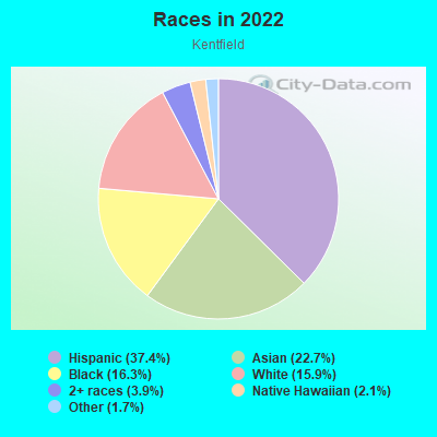
- 1,48637.4%Hispanic or Latino
- 90222.7%Asian
- 64616.3%Black
- 63415.9%White
- 1563.9%Two or more races
- 832.1%Native Hawaiian and Other
Pacific Islander - 661.7%Some other race
- 20.05%American Indian
Median household income in 2022:
| Kentfield: | $61,610 |
| Stockton: | $76,231 |
Distribution of median household income
![Distribution of median household income]()
- 181Less than $10,000
- 80$10,000 to $19,999
- 141$20,000 to $29,999
- 125$30,000 to $39,999
- 127$40,000 to $49,999
- 81$50,000 to $59,999
- 91$60,000 to $74,999
- 193$75,000 to $99,999
- 76$100,000 to $124,999
- 42$125,000 to $149,999
- 143$150,000 to $199,999
- 63$200,000 or more

Distribution of owner-occupied house/condo value
![Distribution of owner-occupied house/condo value]()
- 128Less than $50,000
- 68$50,000 to $99,999
- 157$100,000 to $149,999
- 47$150,000 to $199,999
- 63$200,000 to $249,999
- 153$250,000 to $299,999
- 223$300,000 to $399,999
- 145$400,000 to $499,999
- 76$500,000 to $749,999
- 26$1,000,000 or more

Distribution of rent paid by renters
![Distribution of rent paid by renters]()
- 26$100 to $199
- 21$200 to $299
- 53$300 to $399
- 97$400 to $499
- 13$500 to $599
- 36$600 to $699
- 55$700 to $799
- 43$800 to $899
- 57$900 to $999
- 237$1,000 to $1,249
- 94$1,250 to $1,499
- 101$1,500 to $1,999
- 48$2,000 or more

Median rent in 2022:
| Kentfield: | $1,138 |
| Stockton: | $1,215 |
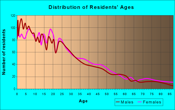
| Males: | 1,661 |
| Females: | 2,140 |
Males:
| This neighborhood: | 29.2 years |
| Whole city: | 33.4 years |
| This neighborhood: | 36.5 years |
| Whole city: | 35.2 years |
Average household size:
| Kentfield: | 14.3 people |
| Stockton: | 3.2 people |
Percentage of family households:
| Kentfield: | 46.8% |
| Stockton: | 51.0% |
| Here: | 36.0% |
| Stockton: | 42.0% |
Percentage of married-couple families with children (among all households):
| Kentfield: | 21.3% |
| Stockton: | 19.2% |
Percentage of single-mother households (among all households):
| Kentfield: | 10.6% |
| Stockton: | 9.1% |
Percentage of never married males 15 years old and over:
Percentage of never married females 15 years old and over:
| Kentfield: | 15.6% |
| Stockton: | 21.6% |
Percentage of never married females 15 years old and over:
| Kentfield: | 24.9% |
| city: | 19.3% |
Percentage of people that speak English not well or not at all:
| Kentfield: | 4.6% |
| Stockton: | 12.0% |
Percentage of people born in this state:
Percentage of people born in another U.S. state:
Percentage of native residents but born outside the U.S.:
Percentage of foreign born residents:
| Here: | 67.1% |
| Stockton: | 66.1% |
Percentage of people born in another U.S. state:
| Kentfield: | 11.6% |
| Stockton: | 7.2% |
Percentage of native residents but born outside the U.S.:
| Here: | 1.4% |
| city: | 1.5% |
Percentage of foreign born residents:
| Here: | 19.9% |
| Stockton: | 25.2% |
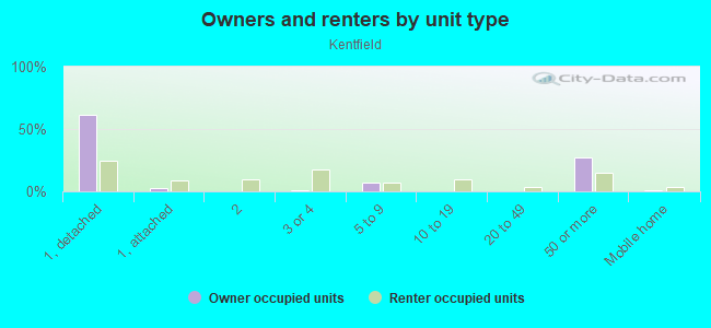
Owner-occupied
Renter-occupied

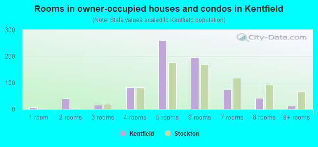
- Rooms in owner-occupied houses and condos in Kentfield
- 71 room
- 402 rooms
- 173 rooms
- 844 rooms
- 2615 rooms
- 1966 rooms
- 747 rooms
- 428 rooms
- 139+ rooms
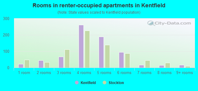
- Rooms in renter-occupied apartments in Kentfield
- 231 room
- 452 rooms
- 673 rooms
- 2614 rooms
- 1895 rooms
- 956 rooms
- 177 rooms
- 158 rooms
- 179+ rooms
Owner-occupied
Renter-occupied
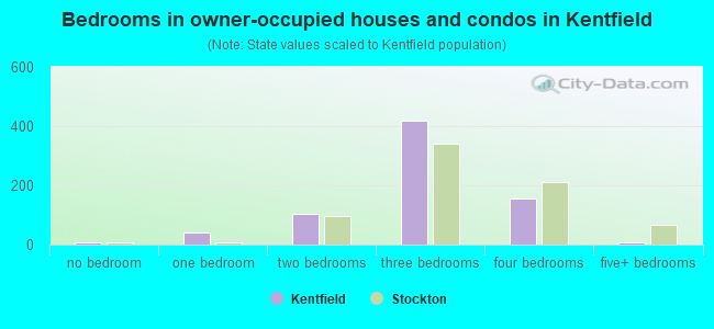
- Bedrooms in owner-occupied houses and condos in Kentfield
- 7no bedroom
- 391 bedroom
- 1022 bedrooms
- 4183 bedrooms
- 1544 bedrooms
- 95+ bedrooms
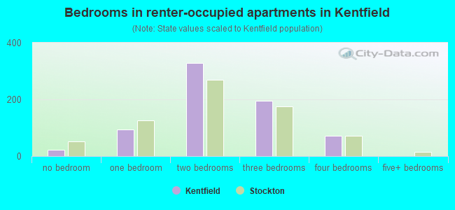
- Bedrooms in renter-occupied apartments in Kentfield
- 23no bedroom
- 941 bedroom
- 3282 bedrooms
- 1943 bedrooms
- 714 bedrooms
- 05+ bedrooms
Average number of cars or other vehicles available in houses/condos:
Average number of cars or other vehicles available in apartments:
| This neighborhood: | 1.8 |
| Stockton: | 2.3 |
Average number of cars or other vehicles available in apartments:
| Here: | 1.6 |
| city: | 1.6 |
Percentage of units with a mortgage:
| Kentfield: | 67.7% |
| Stockton: | 70.5% |
Average estimated value of detached houses in 2022 (58.3% of all units):
| Kentfield: | $320,806 |
| California: | $988,808 |
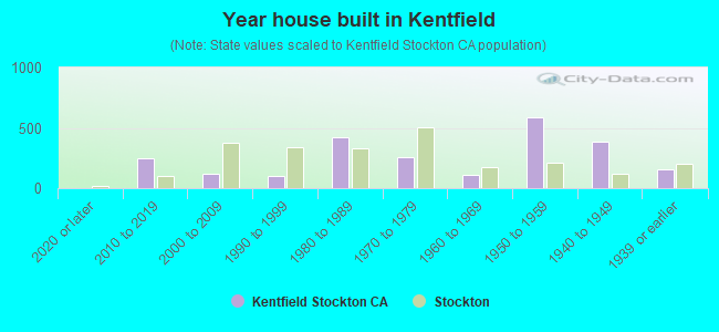
- Year house built in Kentfield
- 02020 or later
- 2482010 to 2019
- 1182000 to 2009
- 1031990 to 1999
- 4251980 to 1989
- 2591970 to 1979
- 1091960 to 1969
- 5861950 to 1959
- 3821940 to 1949
- 1531939 or earlier
City-data.com crime index for city in 2020 (higher means more crime):
| City: | 505.2 |
| U.S. average: | 219.5 |
Travel time to work (commute)
![Travel time to work (commute)]()
- 17Less than 5 minutes
- 1515 to 9 minutes
- 22210 to 14 minutes
- 22215 to 19 minutes
- 15520 to 24 minutes
- 8225 to 29 minutes
- 9630 to 34 minutes
- 2335 to 39 minutes
- 1740 to 44 minutes
- 8845 to 59 minutes
- 11960 to 89 minutes
- 10790 or more minutes

Means of transportation to work
![Means of transportation to work]()
- 78.2%1,157Drove a car alone
- 12.4%183Carpooled
- 0.9%14Bus
- 1.7%25Long-distance train or commuter rail
- 0.5%8Bicycle
- 1.5%22Walked
- 2.0%29Other means
- 6.8%100Worked at home

Time leaving home to go to work
![Time leaving home to go to work]()
- 17012:00 a.m. to 4:59 a.m.
- 375:00 a.m. to 5:29 a.m.
- 725:30 a.m. to 5:59 a.m.
- 966:00 a.m. to 6:29 a.m.
- 1016:30 a.m. to 6:59 a.m.
- 1607:00 a.m. to 7:29 a.m.
- 1637:30 a.m. to 7:59 a.m.
- 1098:00 a.m. to 8:29 a.m.
- 228:30 a.m. to 8:59 a.m.
- 869:00 a.m. to 9:59 a.m.
- 7810:00 a.m. to 10:59 a.m.
- 4611:00 a.m. to 11:59 a.m.
- 10812:00 p.m. to 3:59 p.m.
- 1204:00 p.m. to 11:59 p.m.

Occupations of males:
- Percentage of males in management occupations (except farmers):
Here: 4.6% city: 6.6%
- Percentage of males in business and financial operations occupations:
Here: 4.8% city: 2.1%
- Percentage of males in computer and mathematical occupations:
Here: 4.2% city: 2.1%
- Percentage of males in community and social services occupations:
Here: 1.7% city: 1.2%
- Percentage of males in education, training, and library occupations:
Here: 10.5% city: 2.3%
- Percentage of males in healthcare practitioners and technical occupations:
Here: 5.6% city: 2.7%
- Percentage of males in service occupations:
Here: 15.9% city: 16.9%
- Percentage of males in sales and office occupations:
Here: 7.2% city: 13.8%
- Percentage of males in farming, fishing, and forestry occupations:
Here: 3.3% city: 4.6%
- Percentage of males in construction, extraction, and maintenance occupations:
Here: 17.1% city: 10.5%
- Percentage of males in production occupations:
Here: 5.5% city: 8.0%
- Percentage of males in transportation occupations:
Here: 8.9% city: 9.6%
- Percentage of males in material moving occupations:
Here: 6.0% city: 10.7%
Occupations of females:
- Percentage of females in management occupations (except farmers):
Here: 6.2% city: 5.9%
- Percentage of females in business and financial operations occupations:
Here: 4.7% city: 5.2%
- Percentage of females in computer and mathematical occupations:
Here: 5.2% city: 1.0%
- Percentage of females in community and social services occupations:
Here: 4.1% city: 2.9%
- Percentage of females in education, training, and library occupations:
Here: 4.7% city: 7.8%
- Percentage of females in healthcare practitioners and technical occupations:
Here: 4.4% city: 8.3%
- Percentage of females in service occupations:
Here: 29.9% city: 24.4%
- Percentage of females in sales and office occupations:
Here: 25.7% city: 26.5%
- Percentage of females in material moving occupations:
Here: 12.3% city: 6.3%
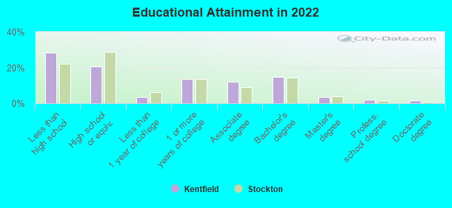
Education in this neighborhood (subdivision or community):
- Percentage of people 3 years and older in K-12 schools:
Kentfield: 17.0% Stockton: 20.8%
- Percentage of people 3 years and older in undergraduate colleges:
Kentfield: 7.5% Stockton: 5.2%
- Percentage of people 3 years and older in grad. or professional schools:
Kentfield: 5.3% Stockton: 1.3%
- Percentage of students K-12 enrolled in private schools:
Kentfield: 22.0% Stockton: 4.2%
Percentage of population below poverty level:
| Kentfield: | 22.0% |
| Stockton: | 14.8% |
Median year owner moved in (as recorded in 2022):
Median year renter moved in (as recorded in 2022):
| Kentfield: | 2007 |
| Stockton: | 2011 |
Median year renter moved in (as recorded in 2022):
| Kentfield: | 2016 |
| Stockton: | 2018 |
Percentage of married-couple families with both working:
| Kentfield: | 43.8% |
| Stockton: | 67.8% |
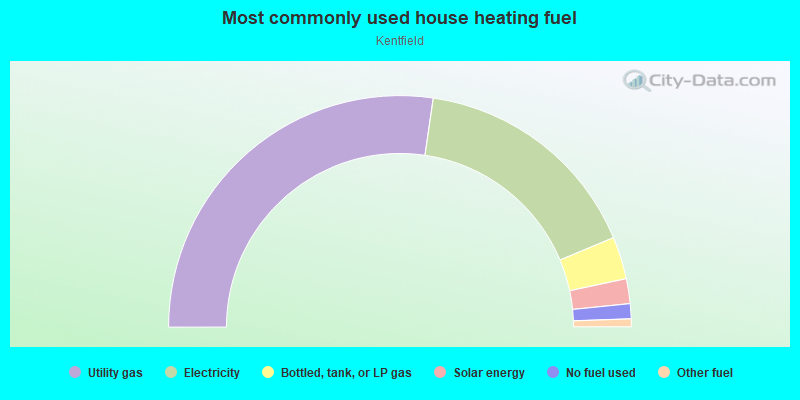
- 54.6%Utility gas
- 32.8%Electricity
- 5.9%Bottled, tank, or LP gas
- 3.5%Solar energy
- 2.1%No fuel used
- 1.1%Other fuel
Roads and streets:
E Bianchi Rd
Length: 1.13 miles
Directions: E-W, SW-NE
Address range: 1 to 1299
Directions: E-W, SW-NE
Address range: 1 to 1299
E March Ln
Length: 1.11 miles
Directions: E-W, SW-NE
Address range: 1 to 1299
Directions: E-W, SW-NE
Address range: 1 to 1299
West Ln
Length: 0.89 miles
Directions: N-S, SE-NW
Address range: 4300 to 5098
Directions: N-S, SE-NW
Address range: 4300 to 5098
Kentfield Rd
Length: 0.39 miles
Direction: SE-NW
Address range: 4500 to 4999
Direction: SE-NW
Address range: 4500 to 4999
Coventry Dr
Length: 0.39 miles
Directions: E-W, SW-NE
Address range: 200 to 699
Directions: E-W, SW-NE
Address range: 200 to 699
Hillsboro Way
Length: 0.35 miles
Directions: N-S, SE-NW, SW-NE
Address range: 4500 to 5099
Directions: N-S, SE-NW, SW-NE
Address range: 4500 to 5099
N el Dorado St
Length: 0.35 miles
Directions: N-S, SE-NW
Address range: 4400 to 4499
Directions: N-S, SE-NW
Address range: 4400 to 4499
Burnham Cir
Length: 0.31 miles
Directions: E-W, N-S, SE-NW, SW-NE
Address range: 4500 to 4699
Directions: E-W, N-S, SE-NW, SW-NE
Address range: 4500 to 4699
Greensboro Way
Length: 0.29 miles
Directions: E-W, N-S, SW-NE
Address range: 4500 to 4999
Directions: E-W, N-S, SW-NE
Address range: 4500 to 4999
Claremont Ave
Length: 0.29 miles
Direction: SE-NW
Address range: 4500 to 4899
Direction: SE-NW
Address range: 4500 to 4899
Cambridge Dr
Length: 0.27 miles
Directions: E-W, SW-NE
Address range: 600 to 899
Directions: E-W, SW-NE
Address range: 600 to 899
Clowes St
Length: 0.27 miles
Directions: E-W, N-S, SW-NE
Address range: 4700 to 4999
Directions: E-W, N-S, SW-NE
Address range: 4700 to 4999
W March Ln
Length: 0.27 miles
Direction: SW-NE
Address range: 1 to 199
Direction: SW-NE
Address range: 1 to 199
Dorset St
Length: 0.25 miles
Directions: E-W, N-S, SE-NW, SW-NE
Address range: 4400 to 4699
Directions: E-W, N-S, SE-NW, SW-NE
Address range: 4400 to 4699
Berkshire Ln
Length: 0.22 miles
Direction: SW-NE
Address range: 200 to 346
Direction: SW-NE
Address range: 200 to 346
W Pardee Ln
Length: 0.21 miles
Directions: E-W, N-S, SW-NE
Address range: 2 to 99
Directions: E-W, N-S, SW-NE
Address range: 2 to 99
Gold Run Pl
Length: 0.20 miles
Directions: E-W, N-S, SE-NW, SW-NE
Address range: 1 to 59
Directions: E-W, N-S, SE-NW, SW-NE
Address range: 1 to 59
Townehome Dr
Length: 0.20 miles
Directions: N-S, SE-NW
Address range: 4400 to 4499
Directions: N-S, SE-NW
Address range: 4400 to 4499
Birmingham Way
Length: 0.19 miles
Directions: N-S, SE-NW
Address range: 4600 to 4939
Directions: N-S, SE-NW
Address range: 4600 to 4939
Calandria St
Length: 0.18 miles
Directions: N-S, SE-NW
Address range: 4400 to 4499
Directions: N-S, SE-NW
Address range: 4400 to 4499
Huntington Ln
Length: 0.18 miles
Directions: E-W, N-S, SE-NW, SW-NE
Address range: 4718 to 4999
Directions: E-W, N-S, SE-NW, SW-NE
Address range: 4718 to 4999
Clowes Ct
Length: 0.18 miles
Direction: E-W
Direction: E-W
Woodvale
Length: 0.17 miles
Direction: E-W
Direction: E-W
Tanglewood Ln
Length: 0.17 miles
Directions: E-W, N-S, SE-NW
Address range: 4700 to 4999
Directions: E-W, N-S, SE-NW
Address range: 4700 to 4999
Woodbine
Length: 0.16 miles
Directions: E-W, N-S, SE-NW
Directions: E-W, N-S, SE-NW
W Jamestown St
Length: 0.16 miles
Directions: E-W, SW-NE
Address range: 1 to 99
Directions: E-W, SW-NE
Address range: 1 to 99
Denby Ln
Length: 0.16 miles
Directions: E-W, N-S, SE-NW, SW-NE
Address range: 4400 to 4499
Directions: E-W, N-S, SE-NW, SW-NE
Address range: 4400 to 4499
Jamestown St
Length: 0.16 miles
Directions: E-W, SW-NE
Address range: 50 to 199
Directions: E-W, SW-NE
Address range: 50 to 199
Pickwood Ln
Length: 0.16 miles
Directions: E-W, SW-NE
Address range: 300 to 499
Directions: E-W, SW-NE
Address range: 300 to 499
la Cresta Way
Length: 0.15 miles
Directions: E-W, N-S, SE-NW, SW-NE
Address range: 4400 to 4483
Directions: E-W, N-S, SE-NW, SW-NE
Address range: 4400 to 4483
Hemingway Dr
Length: 0.15 miles
Directions: E-W, SW-NE
Address range: 700 to 899
Directions: E-W, SW-NE
Address range: 700 to 899
Caribrook Way
Length: 0.14 miles
Direction: E-W
Address range: 400 to 599
Direction: E-W
Address range: 400 to 599
Willow Oak
Length: 0.13 miles
Direction: E-W
Direction: E-W
Gateway Ct
Length: 0.13 miles
Directions: N-S, SW-NE
Address range: 1 to 199
Directions: N-S, SW-NE
Address range: 1 to 199
Surrey Ln
Length: 0.13 miles
Directions: E-W, SW-NE
Address range: 200 to 299
Directions: E-W, SW-NE
Address range: 200 to 299
Sousa St
Length: 0.13 miles
Direction: SE-NW
Address range: 4500 to 5598
Direction: SE-NW
Address range: 4500 to 5598
Oakfield
Length: 0.12 miles
Directions: E-W, N-S
Directions: E-W, N-S
Colebrook Way
Length: 0.11 miles
Directions: N-S, SE-NW, SW-NE
Address range: 4800 to 4961
Directions: N-S, SE-NW, SW-NE
Address range: 4800 to 4961
Westwood Ln
Length: 0.11 miles
Directions: N-S, SW-NE
Address range: 301 to 417
Directions: N-S, SW-NE
Address range: 301 to 417
W Bianchi Rd
Length: 0.11 miles
Directions: E-W, SW-NE
Address range: 1 to 84
Directions: E-W, SW-NE
Address range: 1 to 84
Orchard
Length: 0.11 miles
Direction: E-W
Direction: E-W
Palm Plaza Dr
Length: 0.08 miles
Direction: N-S
Direction: N-S
Huntington Ct
Length: 0.08 miles
Direction: SW-NE
Address range: 300 to 399
Direction: SW-NE
Address range: 300 to 399
E Jamestown St
Length: 0.07 miles
Direction: E-W
Address range: 1 to 65
Direction: E-W
Address range: 1 to 65
Hemingway Ct
Length: 0.07 miles
Directions: N-S, SE-NW
Address range: 4500 to 4599
Directions: N-S, SE-NW
Address range: 4500 to 4599
Cotton Ct
Length: 0.07 miles
Directions: N-S, SE-NW
Address range: 4400 to 4499
Directions: N-S, SE-NW
Address range: 4400 to 4499
Westwood Ct
Length: 0.05 miles
Direction: SE-NW
Address range: 4700 to 4734
Direction: SE-NW
Address range: 4700 to 4734
Birmingham Ct
Length: 0.05 miles
Direction: E-W
Address range: 800 to 831
Direction: E-W
Address range: 800 to 831
Tanglewood Ct
Length: 0.05 miles
Directions: N-S, SE-NW
Directions: N-S, SE-NW
Shelley Ct
Length: 0.05 miles
Direction: N-S
Address range: 4500 to 4699
Direction: N-S
Address range: 4500 to 4699
Parkvale
Length: 0.05 miles
Direction: N-S
Direction: N-S
Greensboro Ct
Length: 0.04 miles
Direction: E-W
Address range: 900 to 999
Direction: E-W
Address range: 900 to 999
Pardee Ln
Length: 0.04 miles
Directions: N-S, SE-NW
Address range: 1 to 4
Directions: N-S, SE-NW
Address range: 1 to 4
Burnham Ct
Length: 0.04 miles
Direction: E-W
Address range: 600 to 622
Direction: E-W
Address range: 600 to 622
Northpark Ct
Length: 0.03 miles
Direction: E-W
Direction: E-W
Willow Oak Ct
Length: 0.02 miles
Direction: N-S
Direction: N-S
Railroad features:
Union Pacific RR
Length: 0.59 miles
Direction: N-S
Direction: N-S
Other features:
Mokelumne Aqueduct
Length: 0.64 miles
Direction: SW-NE
Direction: SW-NE
Woodbridge Irrigation District Cnl
Length: 0.15 miles
Direction: N-S
Direction: N-S
Other features:
Calaveras Riv
Length: 0.06 miles
Direction: E-W
Direction: E-W