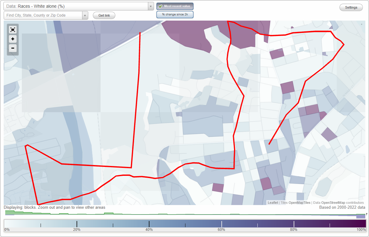
Keenan Terrace neighborhood in Columbia, South Carolina (SC), 29203 detailed profile
Settings
X

Business Search - 14 Million verified businesses
Area: 3.079 square miles
Population: 5,876
Population density:
| Keenan Terrace: | 1,908 people per square mile |
| Columbia: | 1,113 people per square mile |

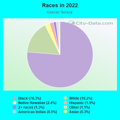
- 4,73876.3%Black
- 1,00516.2%White
- 1502.4%Native Hawaiian and Other
Pacific Islander - 1201.9%Hispanic or Latino
- 791.3%Two or more races
- 671.1%Some other race
- 340.5%American Indian
- 190.3%Asian
Distribution of median household income
![Distribution of median household income]()
- 296Less than $10,000
- 274$10,000 to $19,999
- 276$20,000 to $29,999
- 344$30,000 to $39,999
- 217$40,000 to $49,999
- 163$50,000 to $59,999
- 280$60,000 to $74,999
- 340$75,000 to $99,999
- 137$100,000 to $124,999
- 237$125,000 to $149,999
- 103$150,000 to $199,999
- 65$200,000 or more

Distribution of owner-occupied house/condo value
![Distribution of owner-occupied house/condo value]()
- 416Less than $50,000
- 643$50,000 to $99,999
- 289$100,000 to $149,999
- 259$150,000 to $199,999
- 254$200,000 to $249,999
- 107$250,000 to $299,999
- 204$300,000 to $399,999
- 49$400,000 to $499,999
- 34$500,000 to $749,999
- 42$750,000 to $999,999
- 114$1,000,000 or more

Distribution of rent paid by renters
![Distribution of rent paid by renters]()
- 110Less than $100
- 210$100 to $199
- 419$200 to $299
- 133$300 to $399
- 221$400 to $499
- 282$500 to $599
- 387$600 to $699
- 347$700 to $799
- 139$800 to $899
- 128$900 to $999
- 61$1,000 to $1,249
- 151$1,250 to $1,499
- 90$1,500 to $1,999
- 42$2,000 or more

Median rent in 2022:
| Keenan Terrace: | $729 |
| Columbia: | $975 |
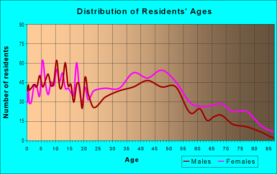
| Males: | 3,053 |
| Females: | 2,822 |
Males:
| This neighborhood: | 35.9 years |
| Whole city: | 27.5 years |
| This neighborhood: | 38.6 years |
| Whole city: | 29.3 years |
Average household size:
| Keenan Terrace: | 5.8 people |
| Columbia: | 2.1 people |
Percentage of family households:
| Keenan Terrace: | 41.8% |
| Columbia: | 35.2% |
| Here: | 19.5% |
| Columbia: | 27.5% |
Percentage of married-couple families with children (among all households):
| Keenan Terrace: | 14.0% |
| Columbia: | 23.7% |
Percentage of single-mother households (among all households):
| Keenan Terrace: | 30.0% |
| Columbia: | 12.1% |
Percentage of never married males 15 years old and over:
Percentage of never married females 15 years old and over:
| Keenan Terrace: | 28.2% |
| Columbia: | 31.8% |
Percentage of never married females 15 years old and over:
| Keenan Terrace: | 25.6% |
| city: | 26.3% |
Percentage of people that speak English not well or not at all:
| Keenan Terrace: | 1.6% |
| Columbia: | 0.6% |
Percentage of people born in this state:
Percentage of people born in another U.S. state:
Percentage of native residents but born outside the U.S.:
Percentage of foreign born residents:
| Here: | 73.0% |
| Columbia: | 53.1% |
Percentage of people born in another U.S. state:
| Keenan Terrace: | 24.6% |
| Columbia: | 40.1% |
Percentage of native residents but born outside the U.S.:
| Here: | 1.3% |
| city: | 2.2% |
Percentage of foreign born residents:
| Here: | 1.9% |
| Columbia: | 4.6% |
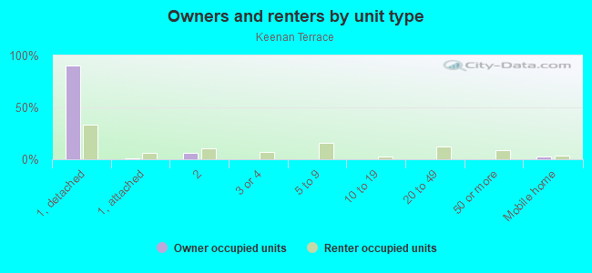
Owner-occupied
Renter-occupied

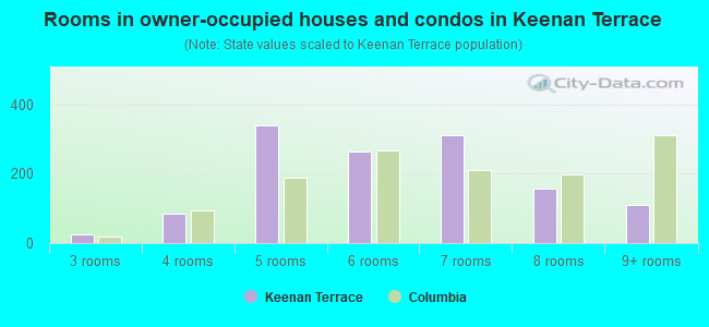
- Rooms in owner-occupied houses and condos in Keenan Terrace
- 01 room
- 02 rooms
- 243 rooms
- 844 rooms
- 3395 rooms
- 2646 rooms
- 3127 rooms
- 1588 rooms
- 1109+ rooms
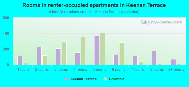
- Rooms in renter-occupied apartments in Keenan Terrace
- 1141 room
- 2292 rooms
- 2073 rooms
- 1564 rooms
- 3725 rooms
- 1336 rooms
- 1137 rooms
- 1768 rooms
- 719+ rooms
Owner-occupied
Renter-occupied
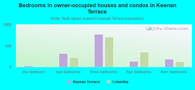
- Bedrooms in owner-occupied houses and condos in Keenan Terrace
- 0no bedroom
- 251 bedroom
- 3222 bedrooms
- 7713 bedrooms
- 1334 bedrooms
- 1845+ bedrooms
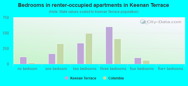
- Bedrooms in renter-occupied apartments in Keenan Terrace
- 114no bedroom
- 1671 bedroom
- 3372 bedrooms
- 6033 bedrooms
- 1024 bedrooms
- 05+ bedrooms
Average number of cars or other vehicles available in houses/condos:
Average number of cars or other vehicles available in apartments:
| This neighborhood: | 1.7 |
| Columbia: | 1.8 |
Average number of cars or other vehicles available in apartments:
| Here: | 1.1 |
| city: | 1.3 |
Percentage of units with a mortgage:
| Keenan Terrace: | 63.4% |
| Columbia: | 67.5% |
Average estimated value of detached houses in 2022 (78.1% of all units):
| Keenan Terrace: | $153,260 |
| Columbia: | $305,357 |

- Year house built in Keenan Terrace
- 422020 or later
- 4492010 to 2019
- 2732000 to 2009
- 1811990 to 1999
- 751980 to 1989
- 3781970 to 1979
- 5251960 to 1969
- 7631950 to 1959
- 2401940 to 1949
- 3621939 or earlier
City-data.com crime index for city in 2020 (higher means more crime):
| City: | 446.0 |
| U.S. average: | 219.5 |
Travel time to work (commute)
![Travel time to work (commute)]()
- 70Less than 5 minutes
- 2935 to 9 minutes
- 34410 to 14 minutes
- 86615 to 19 minutes
- 43020 to 24 minutes
- 7025 to 29 minutes
- 15830 to 34 minutes
- 17635 to 39 minutes
- 32340 to 44 minutes
- 23545 to 59 minutes
- 3860 to 89 minutes
- 5090 or more minutes

Means of transportation to work
![Means of transportation to work]()
- 74.8%1,994Drove a car alone
- 10.4%277Carpooled
- 8.0%214Bus
- 7.7%205Long-distance train or commuter rail
- 15.4%412Taxi
- 3.7%98Bicycle
- 1.3%35Walked
- 4.6%122Other means
- 18.9%505Worked at home

Time leaving home to go to work
![Time leaving home to go to work]()
- 7312:00 a.m. to 4:59 a.m.
- 625:00 a.m. to 5:29 a.m.
- 705:30 a.m. to 5:59 a.m.
- 936:00 a.m. to 6:29 a.m.
- 2466:30 a.m. to 6:59 a.m.
- 2067:00 a.m. to 7:29 a.m.
- 2557:30 a.m. to 7:59 a.m.
- 3738:00 a.m. to 8:29 a.m.
- 1748:30 a.m. to 8:59 a.m.
- 4739:00 a.m. to 9:59 a.m.
- 20910:00 a.m. to 10:59 a.m.
- 9111:00 a.m. to 11:59 a.m.
- 17812:00 p.m. to 3:59 p.m.
- 1414:00 p.m. to 11:59 p.m.

Occupations of males:
- Percentage of males in management occupations (except farmers):
Here: 17.3% city: 12.3%
- Percentage of males in business and financial operations occupations:
Here: 3.3% city: 4.6%
- Percentage of males in arts, design, entertainment, sports, and media occupations:
Here: 1.5% city: 2.0%
- Percentage of males in healthcare practitioners and technical occupations:
Here: 1.4% city: 4.6%
- Percentage of males in service occupations:
Here: 20.3% city: 18.4%
- Percentage of males in sales and office occupations:
Here: 20.1% city: 16.6%
- Percentage of males in farming, fishing, and forestry occupations:
Here: 1.1% city: 0.7%
- Percentage of males in construction, extraction, and maintenance occupations:
Here: 2.7% city: 4.8%
- Percentage of males in production occupations:
Here: 10.8% city: 3.9%
- Percentage of males in transportation occupations:
Here: 6.9% city: 4.1%
- Percentage of males in material moving occupations:
Here: 6.8% city: 5.8%
Occupations of females:
- Percentage of females in management occupations (except farmers):
Here: 7.3% city: 8.8%
- Percentage of females in business and financial operations occupations:
Here: 3.1% city: 6.4%
- Percentage of females in architecture and engineering occupations:
Here: 1.0% city: 0.8%
- Percentage of females in community and social services occupations:
Here: 6.7% city: 2.6%
- Percentage of females in education, training, and library occupations:
Here: 4.7% city: 11.5%
- Percentage of females in arts, design, entertainment, sports, and media occupations:
Here: 1.2% city: 2.6%
- Percentage of females in healthcare practitioners and technical occupations:
Here: 9.5% city: 8.7%
- Percentage of females in service occupations:
Here: 19.6% city: 20.2%
- Percentage of females in sales and office occupations:
Here: 30.9% city: 26.9%
- Percentage of females in farming, fishing, and forestry occupations:
Here: 1.4% city: 0.1%
- Percentage of females in production occupations:
Here: 9.5% city: 3.3%
- Percentage of females in material moving occupations:
Here: 3.3% city: 1.7%
Percentage of people 16-64 in Armed Forces:
| Keenan Terrace: | 0.0% |
| Columbia: | 7.2% |
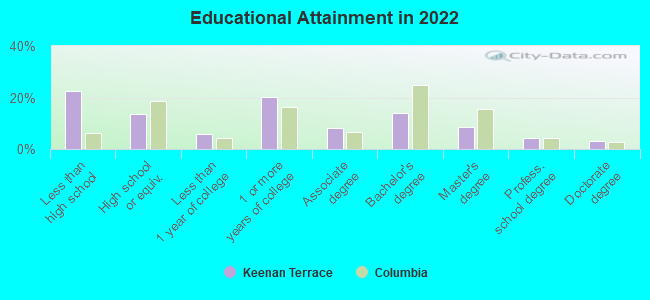
Education in this neighborhood (subdivision or community):
- Percentage of people 3 years and older in K-12 schools:
Keenan Terrace: 19.5% Columbia: 12.2%
- Percentage of people 3 years and older in undergraduate colleges:
Keenan Terrace: 6.6% Columbia: 16.2%
- Percentage of people 3 years and older in grad. or professional schools:
Keenan Terrace: 5.0% Columbia: 3.5%
- Percentage of students K-12 enrolled in private schools:
Keenan Terrace: 48.3% Columbia: 24.2%
Percentage of population below poverty level:
| Keenan Terrace: | 31.1% |
| Columbia: | 20.7% |
Median year owner moved in (as recorded in 2022):
Median year renter moved in (as recorded in 2022):
| Keenan Terrace: | 2002 |
| Columbia: | 2013 |
Median year renter moved in (as recorded in 2022):
| Keenan Terrace: | 2017 |
| Columbia: | 2022 |
Percentage of married-couple families with both working:
| Keenan Terrace: | 176.3% |
| Columbia: | 72.3% |
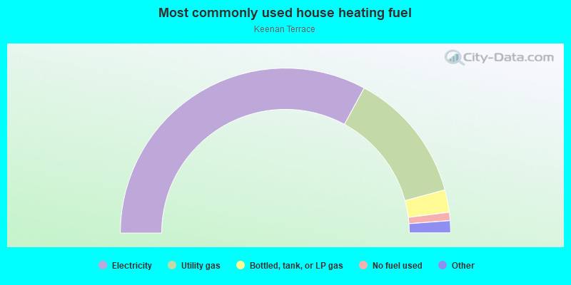
- 65.8%Electricity
- 25.8%Utility gas
- 4.4%Bottled, tank, or LP gas
- 1.6%No fuel used
- 1.0%Fuel oil, kerosene, etc.
- 0.8%Wood
- 0.6%Other fuel
Limited-access highways (interstate or state) in this neighborhood:
I- 20
Length: 1.29 miles
Directions: E-W, SW-NE
Directions: E-W, SW-NE
Highways in this neighborhood:
Monticello Rd (State Hwy 215)
Length: 2.02 miles
Directions: E-W, N-S, SE-NW, SW-NE
Address range: 3900 to 5821
Directions: E-W, N-S, SE-NW, SW-NE
Address range: 3900 to 5821
River Dr (US Hwy 176)
Length: 0.96 miles
Directions: E-W, SE-NW, SW-NE
Address range: 3600 to 4205
Directions: E-W, SE-NW, SW-NE
Address range: 3600 to 4205
State Hwy 215 (US Hwy 321, N Main St, US Hwy 21)
Length: 0.50 miles
Directions: N-S, SE-NW, SW-NE
Address range: 3500 to 3907
Directions: N-S, SE-NW, SW-NE
Address range: 3500 to 3907
US Hwy 176 (Broad River Rd)
Length: 0.03 miles
Direction: E-W
Address range: 400 to 406
Direction: E-W
Address range: 400 to 406
Roads and streets:
Ridgewood Ave
Length: 1.29 miles
Directions: N-S, SE-NW
Address range: 1500 to 5099
Directions: N-S, SE-NW
Address range: 1500 to 5099
Duke Ave
Length: 1.11 miles
Direction: E-W
Address range: 1 to 999
Direction: E-W
Address range: 1 to 999
Palmetto Ave
Length: 1.07 miles
Directions: E-W, N-S, SE-NW, SW-NE
Address range: 3400 to 4499
Directions: E-W, N-S, SE-NW, SW-NE
Address range: 3400 to 4499
Hillcrest Ave
Length: 1.03 miles
Directions: E-W, SE-NW
Address range: 1 to 799
Directions: E-W, SE-NW
Address range: 1 to 799
Abingdon Rd
Length: 0.98 miles
Directions: N-S, SW-NE
Address range: 3300 to 4499
Directions: N-S, SW-NE
Address range: 3300 to 4499
Brickyard Rd
Length: 0.96 miles
Directions: E-W, SE-NW
Address range: 100 to 5299
Directions: E-W, SE-NW
Address range: 100 to 5299
Clement Rd
Length: 0.93 miles
Directions: E-W, N-S, SE-NW, SW-NE
Address range: 3600 to 4099
Directions: E-W, N-S, SE-NW, SW-NE
Address range: 3600 to 4099
Summerlea Dr
Length: 0.86 miles
Directions: E-W, N-S, SE-NW
Address range: 100 to 699
Directions: E-W, N-S, SE-NW
Address range: 100 to 699
Sunset Dr
Length: 0.86 miles
Directions: E-W, SE-NW, SW-NE
Address range: 300 to 1199
Directions: E-W, SE-NW, SW-NE
Address range: 300 to 1199
Mountain Dr
Length: 0.76 miles
Directions: E-W, N-S, SE-NW, SW-NE
Address range: 3900 to 4499
Directions: E-W, N-S, SE-NW, SW-NE
Address range: 3900 to 4499
Williamsburg Dr
Length: 0.75 miles
Directions: E-W, N-S, SE-NW, SW-NE
Address range: 4000 to 4599
Directions: E-W, N-S, SE-NW, SW-NE
Address range: 4000 to 4599
Pineneedle Rd
Length: 0.71 miles
Direction: E-W
Address range: 200 to 499
Direction: E-W
Address range: 200 to 499
Westwood Ave
Length: 0.69 miles
Directions: E-W, SW-NE
Address range: 101 to 499
Directions: E-W, SW-NE
Address range: 101 to 499
Avondale Dr
Length: 0.68 miles
Directions: E-W, SE-NW
Address range: 400 to 1199
Directions: E-W, SE-NW
Address range: 400 to 1199
Margrave Rd
Length: 0.68 miles
Directions: N-S, SE-NW
Address range: 3300 to 4099
Directions: N-S, SE-NW
Address range: 3300 to 4099
Lakeside Ave
Length: 0.66 miles
Direction: E-W
Address range: 100 to 599
Direction: E-W
Address range: 100 to 599
Knightner St
Length: 0.63 miles
Directions: E-W, N-S, SE-NW, SW-NE
Address range: 5401 to 5799
Directions: E-W, N-S, SE-NW, SW-NE
Address range: 5401 to 5799
Johnson Ave
Length: 0.61 miles
Direction: E-W
Address range: 500 to 1099
Direction: E-W
Address range: 500 to 1099
W Miriam Ave
Length: 0.60 miles
Directions: E-W, N-S, SW-NE
Address range: 100 to 599
Directions: E-W, N-S, SW-NE
Address range: 100 to 599
Pond View Rd
Length: 0.57 miles
Directions: E-W, N-S, SW-NE
Directions: E-W, N-S, SW-NE
Wildwood Ave
Length: 0.54 miles
Direction: E-W
Address range: 300 to 699
Direction: E-W
Address range: 300 to 699
W Lakeside Ave
Length: 0.53 miles
Directions: E-W, N-S, SE-NW, SW-NE
Address range: 100 to 499
Directions: E-W, N-S, SE-NW, SW-NE
Address range: 100 to 499
Ardincaple Dr
Length: 0.52 miles
Directions: E-W, N-S, SE-NW, SW-NE
Address range: 3600 to 3999
Directions: E-W, N-S, SE-NW, SW-NE
Address range: 3600 to 3999
Rugby St
Length: 0.52 miles
Directions: E-W, N-S, SE-NW, SW-NE
Address range: 4800 to 5099
Directions: E-W, N-S, SE-NW, SW-NE
Address range: 4800 to 5099
Wildsmere Ave
Length: 0.52 miles
Directions: E-W, SE-NW
Address range: 100 to 599
Directions: E-W, SE-NW
Address range: 100 to 599
Jackson Ave
Length: 0.50 miles
Direction: E-W
Address range: 500 to 999
Direction: E-W
Address range: 500 to 999
McRae St
Length: 0.46 miles
Directions: E-W, SE-NW, SW-NE
Address range: 2 to 3709
Directions: E-W, SE-NW, SW-NE
Address range: 2 to 3709
Ridgewood Camp Rd
Length: 0.45 miles
Directions: E-W, N-S, SE-NW
Address range: 628 to 5499
Directions: E-W, N-S, SE-NW
Address range: 628 to 5499
Lamar St
Length: 0.44 miles
Direction: N-S
Address range: 3700 to 4099
Direction: N-S
Address range: 3700 to 4099
Ryan St
Length: 0.41 miles
Directions: E-W, N-S, SW-NE
Address range: 4300 to 4799
Directions: E-W, N-S, SW-NE
Address range: 4300 to 4799
Hart St
Length: 0.41 miles
Directions: E-W, N-S, SW-NE
Address range: 1 to 399
Directions: E-W, N-S, SW-NE
Address range: 1 to 399
Falling Springs Rd
Length: 0.40 miles
Directions: E-W, SE-NW
Address range: 3600 to 3799
Directions: E-W, SE-NW
Address range: 3600 to 3799
Barrington Dr
Length: 0.39 miles
Directions: E-W, N-S, SE-NW, SW-NE
Address range: 4800 to 5099
Directions: E-W, N-S, SE-NW, SW-NE
Address range: 4800 to 5099
McQueen St
Length: 0.38 miles
Directions: E-W, N-S, SE-NW, SW-NE
Directions: E-W, N-S, SE-NW, SW-NE
Richcreek Rd
Length: 0.36 miles
Directions: E-W, N-S, SE-NW
Address range: 100 to 499
Directions: E-W, N-S, SE-NW
Address range: 100 to 499
Kensington Rd
Length: 0.36 miles
Directions: E-W, N-S, SW-NE
Address range: 100 to 3599
Directions: E-W, N-S, SW-NE
Address range: 100 to 3599
Hanover Ave
Length: 0.35 miles
Direction: E-W
Address range: 100 to 364
Direction: E-W
Address range: 100 to 364
Woodridge Dr
Length: 0.34 miles
Directions: N-S, SE-NW
Address range: 4100 to 4399
Directions: N-S, SE-NW
Address range: 4100 to 4399
S-40-1206 (Myles Ave)
Length: 0.33 miles
Directions: E-W, SW-NE
Address range: 300 to 499
Directions: E-W, SW-NE
Address range: 300 to 499
Brookridge Dr
Length: 0.32 miles
Directions: E-W, N-S, SE-NW, SW-NE
Address range: 4300 to 4379
Directions: E-W, N-S, SE-NW, SW-NE
Address range: 4300 to 4379
Pearl St
Length: 0.31 miles
Directions: N-S, SE-NW
Address range: 3700 to 3999
Directions: N-S, SE-NW
Address range: 3700 to 3999
Chesterfield Dr
Length: 0.31 miles
Directions: E-W, SE-NW
Address range: 4100 to 4299
Directions: E-W, SE-NW
Address range: 4100 to 4299
Belle Claire Dr
Length: 0.31 miles
Direction: E-W
Address range: 400 to 699
Direction: E-W
Address range: 400 to 699
Kortright St
Length: 0.30 miles
Direction: E-W
Address range: 600 to 1199
Direction: E-W
Address range: 600 to 1199
Mildred Ave
Length: 0.30 miles
Direction: N-S
Address range: 4000 to 4302
Direction: N-S
Address range: 4000 to 4302
Club Rd
Length: 0.29 miles
Direction: E-W
Address range: 300 to 599
Direction: E-W
Address range: 300 to 599
Barony Dr
Length: 0.28 miles
Directions: N-S, SE-NW, SW-NE
Address range: 4700 to 5099
Directions: N-S, SE-NW, SW-NE
Address range: 4700 to 5099
Brewer St (S-40-909)
Length: 0.28 miles
Directions: E-W, N-S, SE-NW
Address range: 3800 to 3943
Directions: E-W, N-S, SE-NW
Address range: 3800 to 3943
Hulda Ave
Length: 0.28 miles
Directions: N-S, SE-NW, SW-NE
Address range: 4300 to 4699
Directions: N-S, SE-NW, SW-NE
Address range: 4300 to 4699
Catherine Ave
Length: 0.27 miles
Direction: N-S
Address range: 4300 to 4699
Direction: N-S
Address range: 4300 to 4699
Hawthorne Ave
Length: 0.26 miles
Directions: N-S, SW-NE
Address range: 4400 to 4699
Directions: N-S, SW-NE
Address range: 4400 to 4699
Gibson St
Length: 0.25 miles
Directions: N-S, SE-NW
Address range: 3800 to 3999
Directions: N-S, SE-NW
Address range: 3800 to 3999
Byrd Ave
Length: 0.25 miles
Direction: E-W
Address range: 500 to 1110
Direction: E-W
Address range: 500 to 1110
Glenn Ave
Length: 0.23 miles
Direction: E-W
Address range: 300 to 399
Direction: E-W
Address range: 300 to 399
Lewis St
Length: 0.23 miles
Directions: E-W, SE-NW, SW-NE
Address range: 400 to 699
Directions: E-W, SE-NW, SW-NE
Address range: 400 to 699
Coronado Dr
Length: 0.23 miles
Directions: E-W, SW-NE
Address range: 4000 to 4199
Directions: E-W, SW-NE
Address range: 4000 to 4199
Hazelhurst Rd
Length: 0.23 miles
Direction: N-S
Address range: 3400 to 3599
Direction: N-S
Address range: 3400 to 3599
Miriam Ave
Length: 0.23 miles
Direction: E-W
Address range: 100 to 299
Direction: E-W
Address range: 100 to 299
Aberdeen Ave
Length: 0.22 miles
Directions: E-W, SE-NW, SW-NE
Address range: 101 to 199
Directions: E-W, SE-NW, SW-NE
Address range: 101 to 199
Cumberland Dr
Length: 0.22 miles
Direction: E-W
Address range: 300 to 499
Direction: E-W
Address range: 300 to 499
Dundee Ln
Length: 0.22 miles
Directions: E-W, N-S, SE-NW
Address range: 1 to 199
Directions: E-W, N-S, SE-NW
Address range: 1 to 199
Baine St
Length: 0.22 miles
Directions: N-S, SE-NW, SW-NE
Address range: 4900 to 5099
Directions: N-S, SE-NW, SW-NE
Address range: 4900 to 5099
Clairton St
Length: 0.22 miles
Directions: E-W, N-S, SE-NW
Address range: 4300 to 4499
Directions: E-W, N-S, SE-NW
Address range: 4300 to 4499
Wellesley Dr
Length: 0.22 miles
Direction: N-S
Address range: 3800 to 3999
Direction: N-S
Address range: 3800 to 3999
Joan St
Length: 0.21 miles
Direction: E-W
Address range: 600 to 699
Direction: E-W
Address range: 600 to 699
W Hanover Ave
Length: 0.21 miles
Direction: E-W
Address range: 100 to 299
Direction: E-W
Address range: 100 to 299
Bellingham Rd
Length: 0.21 miles
Direction: N-S
Address range: 3400 to 3599
Direction: N-S
Address range: 3400 to 3599
Fern Ave
Length: 0.19 miles
Directions: N-S, SE-NW
Address range: 1100 to 3802
Directions: N-S, SE-NW
Address range: 1100 to 3802
Muller Ave
Length: 0.19 miles
Direction: E-W
Address range: 600 to 699
Direction: E-W
Address range: 600 to 699
Suffolk St
Length: 0.17 miles
Direction: E-W
Address range: 500 to 599
Direction: E-W
Address range: 500 to 599
Gonzales Ave
Length: 0.16 miles
Direction: N-S
Address range: 3900 to 4099
Direction: N-S
Address range: 3900 to 4099
Eunice Ave
Length: 0.15 miles
Directions: E-W, SW-NE
Address range: 4400 to 4599
Directions: E-W, SW-NE
Address range: 4400 to 4599
Ayrshire Ave
Length: 0.15 miles
Directions: N-S, SE-NW
Address range: 3800 to 3899
Directions: N-S, SE-NW
Address range: 3800 to 3899
Toal St
Length: 0.14 miles
Directions: E-W, SE-NW
Address range: 400 to 499
Directions: E-W, SE-NW
Address range: 400 to 499
Elk Hill Rd
Length: 0.13 miles
Directions: E-W, N-S, SE-NW
Address range: 100 to 199
Directions: E-W, N-S, SE-NW
Address range: 100 to 199
Hamby St
Length: 0.13 miles
Direction: E-W
Address range: 4800 to 4899
Direction: E-W
Address range: 4800 to 4899
Revelstoke Dr
Length: 0.13 miles
Direction: N-S
Address range: 4300 to 4420
Direction: N-S
Address range: 4300 to 4420
Coles Rd
Length: 0.13 miles
Direction: N-S
Address range: 3400 to 3499
Direction: N-S
Address range: 3400 to 3499
Fair St
Length: 0.13 miles
Direction: N-S
Address range: 4400 to 4499
Direction: N-S
Address range: 4400 to 4499
Elliott Ave
Length: 0.13 miles
Direction: E-W
Address range: 500 to 599
Direction: E-W
Address range: 500 to 599
Steadham Rd
Length: 0.13 miles
Direction: E-W
Direction: E-W
Steadham Ave
Length: 0.13 miles
Direction: E-W
Address range: 400 to 499
Direction: E-W
Address range: 400 to 499
Elmhurst Rd
Length: 0.13 miles
Directions: N-S, SE-NW
Address range: 3400 to 3499
Directions: N-S, SE-NW
Address range: 3400 to 3499
Brooks-Palmer Pl
Length: 0.12 miles
Direction: SE-NW
Address range: 1 to 99
Direction: SE-NW
Address range: 1 to 99
Melbourne Dr
Length: 0.12 miles
Directions: E-W, SE-NW
Address range: 4200 to 4299
Directions: E-W, SE-NW
Address range: 4200 to 4299
Timberline Ln
Length: 0.11 miles
Direction: N-S
Address range: 4500 to 4599
Direction: N-S
Address range: 4500 to 4599
Montlake Ave
Length: 0.11 miles
Directions: E-W, N-S, SE-NW, SW-NE
Address range: 601 to 4699
Directions: E-W, N-S, SE-NW, SW-NE
Address range: 601 to 4699
Summit Ave
Length: 0.11 miles
Direction: E-W
Address range: 500 to 599
Direction: E-W
Address range: 500 to 599
Ronnie St
Length: 0.10 miles
Direction: N-S
Address range: 4000 to 4099
Direction: N-S
Address range: 4000 to 4099
Miller Ave
Length: 0.10 miles
Direction: E-W
Address range: 1100 to 1199
Direction: E-W
Address range: 1100 to 1199
Court Ridge St
Length: 0.10 miles
Direction: N-S
Address range: 4100 to 4299
Direction: N-S
Address range: 4100 to 4299
Knightner Cir
Length: 0.09 miles
Directions: E-W, SE-NW
Address range: 5400 to 5753
Directions: E-W, SE-NW
Address range: 5400 to 5753
Charlotte St
Length: 0.09 miles
Direction: N-S
Address range: 4800 to 4899
Direction: N-S
Address range: 4800 to 4899
S-40-1434 (Clairton Ct)
Length: 0.07 miles
Directions: E-W, SE-NW, SW-NE
Address range: 1 to 199
Directions: E-W, SE-NW, SW-NE
Address range: 1 to 199
Pine Ct
Length: 0.07 miles
Directions: E-W, SW-NE
Directions: E-W, SW-NE
New Ellen Dr
Length: 0.07 miles
Direction: SW-NE
Direction: SW-NE
Miriam Ct
Length: 0.07 miles
Directions: E-W, SE-NW, SW-NE
Address range: 1 to 21
Directions: E-W, SE-NW, SW-NE
Address range: 1 to 21
Falling Springs Ct
Length: 0.06 miles
Directions: SE-NW, SW-NE
Directions: SE-NW, SW-NE
Barony Cir
Length: 0.06 miles
Directions: E-W, N-S, SW-NE
Directions: E-W, N-S, SW-NE
Stokie Dr
Length: 0.06 miles
Direction: N-S
Direction: N-S
Barony Ct
Length: 0.06 miles
Directions: E-W, N-S
Directions: E-W, N-S
Wright St
Length: 0.06 miles
Directions: N-S, SW-NE
Address range: 5400 to 5499
Directions: N-S, SW-NE
Address range: 5400 to 5499
McQueen Dr
Length: 0.06 miles
Directions: N-S, SE-NW
Directions: N-S, SE-NW
Styron Ct
Length: 0.05 miles
Directions: N-S, SE-NW
Address range: 1 to 199
Directions: N-S, SE-NW
Address range: 1 to 199
Dartmouth Ave
Length: 0.05 miles
Direction: E-W
Address range: 500 to 599
Direction: E-W
Address range: 500 to 599
Euclid Ave
Length: 0.05 miles
Direction: N-S
Address range: 4300 to 4399
Direction: N-S
Address range: 4300 to 4399
I-20
Length: 0.04 miles
Direction: SW-NE
Direction: SW-NE
Hilltop Pl
Length: 0.04 miles
Direction: N-S
Address range: 300 to 399
Direction: N-S
Address range: 300 to 399
Bauer Cir
Length: 0.04 miles
Directions: N-S, SE-NW
Address range: 4800 to 4899
Directions: N-S, SE-NW
Address range: 4800 to 4899
Railroad features:
Southern RR
Length: 1.66 miles
Directions: N-S, SE-NW
Directions: N-S, SE-NW
Other features:
Smith Br
Length: 1.89 miles
Directions: E-W, N-S, SE-NW, SW-NE
Directions: E-W, N-S, SE-NW, SW-NE
Crane Crk
Length: 1.25 miles
Directions: E-W, N-S, SE-NW, SW-NE
Directions: E-W, N-S, SE-NW, SW-NE
Diversion Dam
Length: 0.06 miles
Directions: E-W, SW-NE
Directions: E-W, SW-NE