Hilldale neighborhood in Haverhill, Massachusetts (MA), 01832 detailed profile
Settings
X


Business Search - 14 Million verified businesses
Area: 0.897 square miles
Population: 5,137
Population density:
| Hilldale: | 5,729 people per square mile |
| Haverhill: | 2,015 people per square mile |

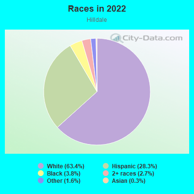
- 3,29663.4%White
- 1,47028.3%Hispanic or Latino
- 1993.8%Black
- 1382.7%Two or more races
- 811.6%Some other race
- 140.3%Asian
Median household income in 2022:
| Hilldale: | $72,868 |
| Haverhill: | $85,561 |
Distribution of median household income
![Distribution of median household income]()
- 136Less than $10,000
- 245$10,000 to $19,999
- 146$20,000 to $29,999
- 92$30,000 to $39,999
- 338$40,000 to $49,999
- 66$50,000 to $59,999
- 229$60,000 to $74,999
- 203$75,000 to $99,999
- 143$100,000 to $124,999
- 187$125,000 to $149,999
- 225$150,000 to $199,999
- 106$200,000 or more

Distribution of owner-occupied house/condo value
![Distribution of owner-occupied house/condo value]()
- 275Less than $50,000
- 23$50,000 to $99,999
- 314$100,000 to $149,999
- 54$150,000 to $199,999
- 44$200,000 to $249,999
- 80$250,000 to $299,999
- 356$300,000 to $399,999
- 213$400,000 to $499,999
- 155$500,000 to $749,999
- 40$750,000 to $999,999
- 46$1,000,000 or more

Distribution of rent paid by renters
![Distribution of rent paid by renters]()
- 252Less than $100
- 278$100 to $199
- 412$200 to $299
- 170$300 to $399
- 169$400 to $499
- 128$500 to $599
- 117$600 to $699
- 118$700 to $799
- 32$800 to $899
- 29$900 to $999
- 163$1,000 to $1,249
- 207$1,250 to $1,499
- 244$1,500 to $1,999
- 215$2,000 or more

| Males: | 2,665 |
| Females: | 2,471 |
Males:
| This neighborhood: | 31.2 years |
| Whole city: | 36.5 years |
| This neighborhood: | 33.0 years |
| Whole city: | 39.2 years |
Average household size:
| Hilldale: | 2.7 people |
| Haverhill: | 2.6 people |
Percentage of family households:
| Hilldale: | 62.2% |
| Haverhill: | 47.7% |
| Here: | 40.5% |
| Haverhill: | 40.3% |
Percentage of married-couple families with children (among all households):
| Hilldale: | 13.6% |
| Haverhill: | 27.0% |
Percentage of single-mother households (among all households):
| Hilldale: | 15.6% |
| Haverhill: | 4.7% |
Percentage of never married males 15 years old and over:
Percentage of never married females 15 years old and over:
| Hilldale: | 25.0% |
| Haverhill: | 19.6% |
Percentage of never married females 15 years old and over:
| Hilldale: | 19.3% |
| city: | 18.8% |
Percentage of people that speak English not well or not at all:
| Hilldale: | 1.7% |
| Haverhill: | 3.7% |
Percentage of people born in this state:
Percentage of people born in another U.S. state:
Percentage of native residents but born outside the U.S.:
Percentage of foreign born residents:
| Here: | 75.0% |
| Haverhill: | 65.4% |
Percentage of people born in another U.S. state:
| Hilldale: | 11.2% |
| Haverhill: | 14.2% |
Percentage of native residents but born outside the U.S.:
| Here: | 3.6% |
| city: | 3.9% |
Percentage of foreign born residents:
| Here: | 10.2% |
| Haverhill: | 16.6% |
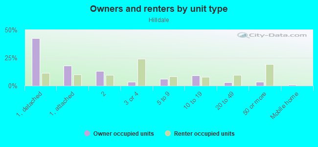
Owner-occupied
Renter-occupied

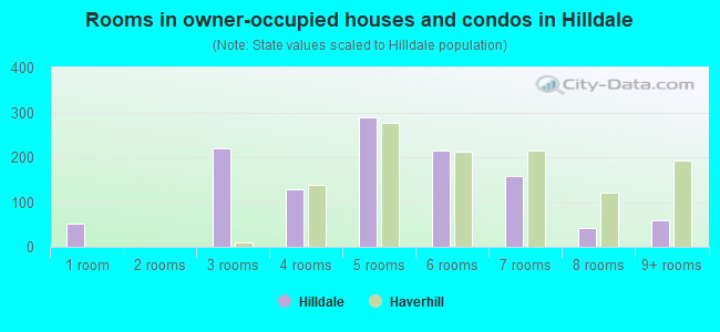
- Rooms in owner-occupied houses and condos in Hilldale
- 531 room
- 02 rooms
- 2203 rooms
- 1294 rooms
- 2895 rooms
- 2166 rooms
- 1587 rooms
- 438 rooms
- 609+ rooms
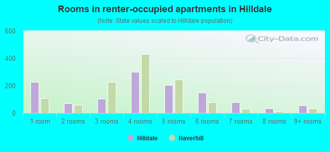
- Rooms in renter-occupied apartments in Hilldale
- 2251 room
- 712 rooms
- 1023 rooms
- 3004 rooms
- 2055 rooms
- 1506 rooms
- 797 rooms
- 358 rooms
- 549+ rooms
Owner-occupied
Renter-occupied
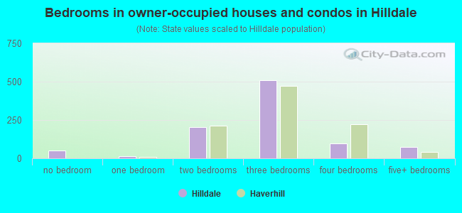
- Bedrooms in owner-occupied houses and condos in Hilldale
- 53no bedroom
- 161 bedroom
- 2042 bedrooms
- 5103 bedrooms
- 984 bedrooms
- 735+ bedrooms
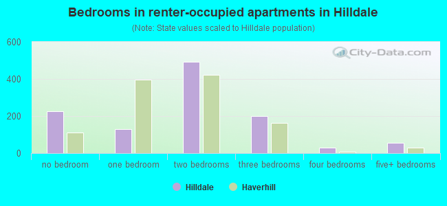
- Bedrooms in renter-occupied apartments in Hilldale
- 226no bedroom
- 1301 bedroom
- 4912 bedrooms
- 1993 bedrooms
- 314 bedrooms
- 545+ bedrooms
Average number of cars or other vehicles available in houses/condos:
Average number of cars or other vehicles available in apartments:
| This neighborhood: | |
| Haverhill: |
Average number of cars or other vehicles available in apartments:
| Here: | 1.3 |
| city: | 1.3 |
Percentage of units with a mortgage:
| Hilldale: | 80.3% |
| Haverhill: | 74.7% |
Average estimated value of detached houses in 2022 (35.0% of all units):
| Hilldale: | $275,275 |
| Haverhill: | $502,054 |
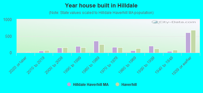
- Year house built in Hilldale
- 02020 or later
- 552010 to 2019
- 1462000 to 2009
- 2001990 to 1999
- 3541980 to 1989
- 1711970 to 1979
- 641960 to 1969
- 2031950 to 1959
- 461940 to 1949
- 6071939 or earlier
City-data.com crime index for city in 2020 (higher means more crime):
| City: | 165.7 |
| U.S. average: | 219.5 |
Travel time to work (commute)
![Travel time to work (commute)]()
- 18Less than 5 minutes
- 1735 to 9 minutes
- 31510 to 14 minutes
- 30315 to 19 minutes
- 22420 to 24 minutes
- 9425 to 29 minutes
- 33830 to 34 minutes
- 18035 to 39 minutes
- 18840 to 44 minutes
- 18845 to 59 minutes
- 22160 to 89 minutes
- 2590 or more minutes

Means of transportation to work
![Means of transportation to work]()
- 84.1%1,998Drove a car alone
- 9.4%223Carpooled
- 17.0%403Bus
- 1.1%26Subway or elevated rail
- 0.5%11Long-distance train or commuter rail
- 3.2%76Taxi
- 0.5%12Bicycle
- 1.8%43Walked
- 5.2%124Other means
- 4.4%104Worked at home

Time leaving home to go to work
![Time leaving home to go to work]()
- 4712:00 a.m. to 4:59 a.m.
- 1505:00 a.m. to 5:29 a.m.
- 1755:30 a.m. to 5:59 a.m.
- 2156:00 a.m. to 6:29 a.m.
- 2216:30 a.m. to 6:59 a.m.
- 2257:00 a.m. to 7:29 a.m.
- 2567:30 a.m. to 7:59 a.m.
- 3488:00 a.m. to 8:29 a.m.
- 288:30 a.m. to 8:59 a.m.
- 849:00 a.m. to 9:59 a.m.
- 2510:00 a.m. to 10:59 a.m.
- 3611:00 a.m. to 11:59 a.m.
- 23412:00 p.m. to 3:59 p.m.
- 2224:00 p.m. to 11:59 p.m.

Occupations of males:
- Percentage of males in management occupations (except farmers):
Here: 13.1% city: 11.9%
- Percentage of males in business and financial operations occupations:
Here: 5.5% city: 6.0%
- Percentage of males in architecture and engineering occupations:
Here: 6.4% city: 3.7%
- Percentage of males in community and social services occupations:
Here: 1.8% city: 1.4%
- Percentage of males in education, training, and library occupations:
Here: 3.4% city: 2.4%
- Percentage of males in healthcare practitioners and technical occupations:
Here: 1.3% city: 2.3%
- Percentage of males in service occupations:
Here: 13.4% city: 14.4%
- Percentage of males in sales and office occupations:
Here: 9.4% city: 15.0%
- Percentage of males in construction, extraction, and maintenance occupations:
Here: 12.2% city: 11.1%
- Percentage of males in production occupations:
Here: 18.5% city: 8.4%
- Percentage of males in transportation occupations:
Here: 3.3% city: 6.4%
- Percentage of males in material moving occupations:
Here: 6.7% city: 2.9%
Occupations of females:
- Percentage of females in management occupations (except farmers):
Here: 9.0% city: 11.6%
- Percentage of females in business and financial operations occupations:
Here: 2.7% city: 5.9%
- Percentage of females in education, training, and library occupations:
Here: 17.7% city: 10.7%
- Percentage of females in healthcare practitioners and technical occupations:
Here: 15.4% city: 8.2%
- Percentage of females in service occupations:
Here: 21.4% city: 23.0%
- Percentage of females in sales and office occupations:
Here: 17.1% city: 22.8%
- Percentage of females in construction, extraction, and maintenance occupations:
Here: 1.9% city: 0.7%
- Percentage of females in production occupations:
Here: 9.6% city: 4.5%
- Percentage of females in transportation occupations:
Here: 1.6% city: 2.0%
- Percentage of females in material moving occupations:
Here: 2.9% city: 2.1%
Percentage of people 16-64 in Armed Forces:
| Hilldale: | 0.0% |
| Haverhill: | 0.1% |
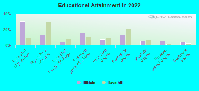
Education in this neighborhood (subdivision or community):
- Percentage of people 3 years and older in K-12 schools:
Hilldale: 21.7% Haverhill: 14.8%
- Percentage of people 3 years and older in undergraduate colleges:
Hilldale: 4.2% Haverhill: 5.7%
- Percentage of people 3 years and older in grad. or professional schools:
Hilldale: 1.0% Haverhill: 0.5%
- Percentage of students K-12 enrolled in private schools:
Hilldale: 30.4% Haverhill: 16.2%
Percentage of population below poverty level:
| Hilldale: | 15.2% |
| Haverhill: | 14.4% |
Percentage of married-couple families with both working:
| Hilldale: | 90.8% |
| Haverhill: | 77.5% |
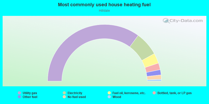
- 70.1%Utility gas
- 13.7%Electricity
- 5.8%Fuel oil, kerosene, etc.
- 3.8%Bottled, tank, or LP gas
- 3.0%Other fuel
- 2.5%No fuel used
- 1.0%Wood
Limited-access highways (interstate or state) in this neighborhood:
Blue Star Memorial Hwy (I- 495)
Length: 0.42 miles
Direction: SW-NE
Direction: SW-NE
Highways in this neighborhood:
State Hwy 97 (Broadway)
Length: 0.52 miles
Directions: E-W, SE-NW
Address range: 4 to 225
Directions: E-W, SE-NW
Address range: 4 to 225
Winter St (State Hwy 97)
Length: 0.12 miles
Directions: E-W, SE-NW
Address range: 292 to 295
Directions: E-W, SE-NW
Address range: 292 to 295
State Hwy 97 (Lafayette Sq)
Length: 0.04 miles
Direction: SE-NW
Address range: 72 to 299
Direction: SE-NW
Address range: 72 to 299
Roads and streets:
Hilldale Ave
Length: 1.60 miles
Directions: E-W, N-S, SE-NW, SW-NE
Address range: 1 to 556
Directions: E-W, N-S, SE-NW, SW-NE
Address range: 1 to 556
Brook St
Length: 0.94 miles
Directions: E-W, SE-NW
Address range: 1 to 280
Directions: E-W, SE-NW
Address range: 1 to 280
Pilgrim Rd
Length: 0.64 miles
Directions: N-S, SE-NW
Address range: 1 to 299
Directions: N-S, SE-NW
Address range: 1 to 299
Bennington St
Length: 0.50 miles
Direction: E-W
Address range: 1 to 199
Direction: E-W
Address range: 1 to 199
Cogswell St
Length: 0.48 miles
Direction: E-W
Address range: 1 to 199
Direction: E-W
Address range: 1 to 199
Monument St
Length: 0.46 miles
Direction: SW-NE
Address range: 100 to 251
Direction: SW-NE
Address range: 100 to 251
Atlanta St
Length: 0.44 miles
Directions: E-W, SE-NW, SW-NE
Address range: 1 to 111
Directions: E-W, SE-NW, SW-NE
Address range: 1 to 111
Emily St
Length: 0.43 miles
Directions: E-W, SE-NW, SW-NE
Address range: 1 to 61
Directions: E-W, SE-NW, SW-NE
Address range: 1 to 61
Eudora St
Length: 0.40 miles
Directions: E-W, SW-NE
Address range: 1 to 99
Directions: E-W, SW-NE
Address range: 1 to 99
Bateman St
Length: 0.39 miles
Directions: E-W, SW-NE
Address range: 1 to 99
Directions: E-W, SW-NE
Address range: 1 to 99
Standish Rd
Length: 0.37 miles
Directions: N-S, SE-NW, SW-NE
Address range: 1 to 99
Directions: N-S, SE-NW, SW-NE
Address range: 1 to 99
Hanover St
Length: 0.28 miles
Directions: E-W, SW-NE
Address range: 1 to 99
Directions: E-W, SW-NE
Address range: 1 to 99
Brandon Rd
Length: 0.28 miles
Directions: E-W, N-S, SE-NW, SW-NE
Address range: 1 to 99
Directions: E-W, N-S, SE-NW, SW-NE
Address range: 1 to 99
Vincent Ave
Length: 0.27 miles
Directions: E-W, SW-NE
Address range: 22 to 61
Directions: E-W, SW-NE
Address range: 22 to 61
Greenough St
Length: 0.27 miles
Direction: SW-NE
Address range: 49 to 99
Direction: SW-NE
Address range: 49 to 99
Acorn St
Length: 0.27 miles
Directions: E-W, SW-NE
Address range: 1 to 99
Directions: E-W, SW-NE
Address range: 1 to 99
Marlon St
Length: 0.26 miles
Direction: SW-NE
Address range: 1 to 99
Direction: SW-NE
Address range: 1 to 99
Willie St
Length: 0.26 miles
Directions: E-W, SW-NE
Address range: 1 to 99
Directions: E-W, SW-NE
Address range: 1 to 99
Taylor St
Length: 0.26 miles
Directions: E-W, SE-NW
Address range: 1 to 99
Directions: E-W, SE-NW
Address range: 1 to 99
Pine Ave
Length: 0.25 miles
Direction: SE-NW
Address range: 1 to 99
Direction: SE-NW
Address range: 1 to 99
Hannah Dustin St
Length: 0.24 miles
Direction: SE-NW
Address range: 1 to 99
Direction: SE-NW
Address range: 1 to 99
Orange St
Length: 0.23 miles
Directions: E-W, SW-NE
Address range: 1 to 99
Directions: E-W, SW-NE
Address range: 1 to 99
Sherman Ave
Length: 0.22 miles
Direction: SE-NW
Address range: 1 to 99
Direction: SE-NW
Address range: 1 to 99
Titcomb St
Length: 0.20 miles
Direction: E-W
Address range: 2 to 21
Direction: E-W
Address range: 2 to 21
Albert Ave
Length: 0.20 miles
Direction: SE-NW
Address range: 1 to 71
Direction: SE-NW
Address range: 1 to 71
Mount Dustin Ave
Length: 0.20 miles
Direction: SE-NW
Address range: 1 to 99
Direction: SE-NW
Address range: 1 to 99
Dartmouth St
Length: 0.19 miles
Directions: N-S, SE-NW
Address range: 1 to 99
Directions: N-S, SE-NW
Address range: 1 to 99
Kathy Dr
Length: 0.19 miles
Directions: N-S, SE-NW, SW-NE
Address range: 1 to 77
Directions: N-S, SE-NW, SW-NE
Address range: 1 to 77
Jefferey Ln
Length: 0.19 miles
Directions: E-W, SW-NE
Address range: 1 to 99
Directions: E-W, SW-NE
Address range: 1 to 99
Brookdale Ln
Length: 0.18 miles
Directions: E-W, N-S, SE-NW, SW-NE
Address range: 1 to 99
Directions: E-W, N-S, SE-NW, SW-NE
Address range: 1 to 99
Lafayette St
Length: 0.18 miles
Direction: E-W
Address range: 1 to 99
Direction: E-W
Address range: 1 to 99
Priscilla Rd
Length: 0.17 miles
Directions: E-W, SE-NW
Directions: E-W, SE-NW
Arthur St
Length: 0.17 miles
Direction: E-W
Address range: 1 to 99
Direction: E-W
Address range: 1 to 99
Bonin Dr
Length: 0.16 miles
Directions: E-W, N-S, SE-NW
Address range: 1 to 99
Directions: E-W, N-S, SE-NW
Address range: 1 to 99
W Acorn St
Length: 0.16 miles
Directions: E-W, SW-NE
Address range: 1 to 21
Directions: E-W, SW-NE
Address range: 1 to 21
Whitney St
Length: 0.15 miles
Directions: E-W, SW-NE
Address range: 1 to 99
Directions: E-W, SW-NE
Address range: 1 to 99
Greenhill Farm Rd
Length: 0.15 miles
Directions: E-W, SW-NE
Address range: 2 to 99
Directions: E-W, SW-NE
Address range: 2 to 99
Altamont St
Length: 0.14 miles
Direction: N-S
Address range: 27 to 99
Direction: N-S
Address range: 27 to 99
Woodcock Ave
Length: 0.14 miles
Direction: N-S
Address range: 1 to 99
Direction: N-S
Address range: 1 to 99
Boscowan St
Length: 0.14 miles
Direction: SE-NW
Address range: 1 to 99
Direction: SE-NW
Address range: 1 to 99
Gerson Way
Length: 0.14 miles
Direction: E-W
Direction: E-W
Federal St
Length: 0.13 miles
Direction: E-W
Address range: 1 to 99
Direction: E-W
Address range: 1 to 99
Maurice St
Length: 0.13 miles
Direction: N-S
Address range: 1 to 99
Direction: N-S
Address range: 1 to 99
W Marlon St
Length: 0.12 miles
Direction: E-W
Address range: 1 to 21
Direction: E-W
Address range: 1 to 21
Edward St
Length: 0.11 miles
Direction: E-W
Direction: E-W
Sotirios Ct
Length: 0.11 miles
Directions: N-S, SW-NE
Address range: 1 to 99
Directions: N-S, SW-NE
Address range: 1 to 99
Angel Ave
Length: 0.11 miles
Direction: SE-NW
Address range: 1 to 99
Direction: SE-NW
Address range: 1 to 99
Bernard St
Length: 0.11 miles
Direction: E-W
Direction: E-W
Albert St
Length: 0.11 miles
Directions: N-S, SE-NW
Address range: 1 to 99
Directions: N-S, SE-NW
Address range: 1 to 99
Hannah St
Length: 0.11 miles
Direction: SW-NE
Direction: SW-NE
Thorndike St
Length: 0.09 miles
Direction: N-S
Address range: 1 to 99
Direction: N-S
Address range: 1 to 99
Johnathan Dustin Ln
Length: 0.09 miles
Directions: E-W, SE-NW, SW-NE
Address range: 1 to 99
Directions: E-W, SE-NW, SW-NE
Address range: 1 to 99
Lapierre St
Length: 0.09 miles
Direction: N-S
Address range: 1 to 99
Direction: N-S
Address range: 1 to 99
Hale St
Length: 0.08 miles
Direction: N-S
Address range: 58 to 102
Direction: N-S
Address range: 58 to 102
Leblanc St
Length: 0.08 miles
Direction: E-W
Address range: 1 to 99
Direction: E-W
Address range: 1 to 99
Little River St
Length: 0.08 miles
Direction: E-W
Address range: 1 to 99
Direction: E-W
Address range: 1 to 99
Whitcomb St
Length: 0.07 miles
Direction: N-S
Address range: 1 to 99
Direction: N-S
Address range: 1 to 99
Willow St
Length: 0.07 miles
Direction: SE-NW
Direction: SE-NW
Dustin Ave
Length: 0.07 miles
Direction: E-W
Address range: 2 to 99
Direction: E-W
Address range: 2 to 99
Benjamin St
Length: 0.07 miles
Direction: E-W
Address range: 1 to 21
Direction: E-W
Address range: 1 to 21
Ball St
Length: 0.06 miles
Directions: N-S, SW-NE
Address range: 1 to 99
Directions: N-S, SW-NE
Address range: 1 to 99
Smith St
Length: 0.06 miles
Direction: SW-NE
Direction: SW-NE
Apple St
Length: 0.06 miles
Direction: E-W
Address range: 1 to 99
Direction: E-W
Address range: 1 to 99
Newton St
Length: 0.06 miles
Directions: E-W, SW-NE
Address range: 1 to 99
Directions: E-W, SW-NE
Address range: 1 to 99
Tyler Ave
Length: 0.06 miles
Directions: E-W, N-S
Address range: 2 to 99
Directions: E-W, N-S
Address range: 2 to 99
Granville Ct
Length: 0.06 miles
Directions: SE-NW, SW-NE
Address range: 1 to 99
Directions: SE-NW, SW-NE
Address range: 1 to 99
Gove Ave
Length: 0.06 miles
Directions: N-S, SE-NW
Address range: 1 to 99
Directions: N-S, SE-NW
Address range: 1 to 99
Wingate Ave
Length: 0.06 miles
Directions: N-S, SW-NE
Address range: 1 to 99
Directions: N-S, SW-NE
Address range: 1 to 99
Cliff St
Length: 0.05 miles
Direction: E-W
Address range: 1 to 99
Direction: E-W
Address range: 1 to 99
Whittier Pl
Length: 0.05 miles
Directions: N-S, SE-NW
Address range: 1 to 99
Directions: N-S, SE-NW
Address range: 1 to 99
Foster St
Length: 0.05 miles
Direction: E-W
Direction: E-W
St Lawrence St
Length: 0.05 miles
Directions: N-S, SE-NW
Address range: 1 to 21
Directions: N-S, SE-NW
Address range: 1 to 21
Olive St
Length: 0.05 miles
Direction: E-W
Address range: 2 to 6
Direction: E-W
Address range: 2 to 6
Dupree St
Length: 0.04 miles
Direction: N-S
Address range: 1 to 99
Direction: N-S
Address range: 1 to 99
Anna St
Length: 0.04 miles
Direction: SE-NW
Address range: 1 to 99
Direction: SE-NW
Address range: 1 to 99
St Botolph St
Length: 0.04 miles
Direction: SW-NE
Address range: 1 to 99
Direction: SW-NE
Address range: 1 to 99
Railroad features:
Boston and Maine RR
Length: 1.21 miles
Direction: SE-NW
Direction: SE-NW
Other features:
Little Riv
Length: 0.03 miles
Direction: SE-NW
Direction: SE-NW