Greenspoint neighborhood in Houston, Texas (TX), 77037, 77038, 77060, 77067 detailed profile
Settings
X


Business Search - 14 Million verified businesses
Area: 7.086 square miles
Population: 12,994
Population density:
| Greenspoint: | 1,834 people per square mile |
| Houston: | 3,977 people per square mile |

- 7,22643.1%Hispanic or Latino
- 4,52127.0%Two or more races
- 3,54321.2%Black
- 8625.1%Asian
- 4632.8%White
- 830.5%American Indian
- 330.2%Some other race
- 170.1%Native Hawaiian and Other
Pacific Islander

Median household income in 2022:
| Greenspoint: | $41,856 |
| Houston: | $60,426 |
Distribution of median household income
![Distribution of median household income]()
- 1,109Less than $10,000
- 482$10,000 to $19,999
- 942$20,000 to $29,999
- 756$30,000 to $39,999
- 673$40,000 to $49,999
- 651$50,000 to $59,999
- 481$60,000 to $74,999
- 162$75,000 to $99,999
- 433$100,000 to $124,999
- 852$125,000 to $149,999
- 466$150,000 to $199,999
- 499$200,000 or more

Distribution of owner-occupied house/condo value
![Distribution of owner-occupied house/condo value]()
- 654Less than $50,000
- 966$50,000 to $99,999
- 5,587$100,000 to $149,999
- 1,069$150,000 to $199,999
- 774$200,000 to $249,999
- 189$250,000 to $299,999
- 82$300,000 to $399,999
- 283$400,000 to $499,999
- 63$500,000 to $749,999

Distribution of rent paid by renters
![Distribution of rent paid by renters]()
- 77Less than $100
- 636$100 to $199
- 84$200 to $299
- 55$400 to $499
- 319$500 to $599
- 780$600 to $699
- 980$700 to $799
- 1,516$800 to $899
- 422$900 to $999
- 736$1,000 to $1,249
- 542$1,250 to $1,499
- 141$1,500 to $1,999
- 107$2,000 or more

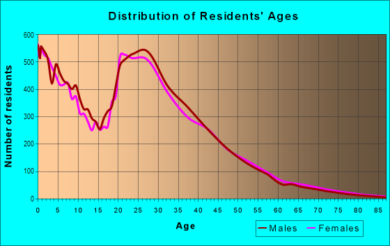
| Males: | 5,976 |
| Females: | 7,018 |
Males:
| This neighborhood: | 31.6 years |
| Whole city: | 34.4 years |
| This neighborhood: | 35.2 years |
| Whole city: | 34.7 years |
Average household size:
| Greenspoint: | 2.8 people |
| Houston: | 2.4 people |
Percentage of family households:
| Greenspoint: | 38.0% |
| Houston: | 43.0% |
| Here: | 25.1% |
| Houston: | 34.7% |
Percentage of married-couple families with children (among all households):
| Greenspoint: | 15.6% |
| Houston: | 23.3% |
Percentage of single-mother households (among all households):
| Greenspoint: | 51.9% |
| Houston: | 13.9% |
Percentage of never married males 15 years old and over:
Percentage of never married females 15 years old and over:
| Greenspoint: | 22.4% |
| Houston: | 22.9% |
Percentage of never married females 15 years old and over:
| Greenspoint: | 24.1% |
| city: | 21.2% |
Percentage of people that speak English not well or not at all:
| Greenspoint: | 13.9% |
| Houston: | 15.9% |
Percentage of people born in this state:
Percentage of people born in another U.S. state:
Percentage of native residents but born outside the U.S.:
Percentage of foreign born residents:
| Here: | 52.7% |
| Houston: | 51.1% |
Percentage of people born in another U.S. state:
| Greenspoint: | 15.2% |
| Houston: | 17.7% |
Percentage of native residents but born outside the U.S.:
| Here: | 1.3% |
| city: | 1.8% |
Percentage of foreign born residents:
| Here: | 30.9% |
| Houston: | 29.4% |

Owner-occupied
Renter-occupied


- Rooms in owner-occupied houses and condos in Greenspoint
- 01 room
- 522 rooms
- 3493 rooms
- 1154 rooms
- 3,5945 rooms
- 3,8576 rooms
- 4757 rooms
- 2838 rooms
- 3769+ rooms

- Rooms in renter-occupied apartments in Greenspoint
- 2591 room
- 6652 rooms
- 1,7463 rooms
- 1,4334 rooms
- 7665 rooms
- 9976 rooms
- 1927 rooms
- 1068 rooms
- 959+ rooms
Owner-occupied
Renter-occupied

- Bedrooms in owner-occupied houses and condos in Greenspoint
- 52no bedroom
- 01 bedroom
- 5822 bedrooms
- 5,9583 bedrooms
- 1,2444 bedrooms
- 815+ bedrooms

- Bedrooms in renter-occupied apartments in Greenspoint
- 259no bedroom
- 3,1101 bedroom
- 8832 bedrooms
- 1,0333 bedrooms
- 1324 bedrooms
- 895+ bedrooms
Average number of cars or other vehicles available in houses/condos:
Average number of cars or other vehicles available in apartments:
| This neighborhood: | |
| Houston: |
Average number of cars or other vehicles available in apartments:
| Here: | 1.3 |
| city: | 1.3 |
Percentage of units with a mortgage:
| Greenspoint: | 40.6% |
| Houston: | 50.8% |

- Year house built in Greenspoint
- 02020 or later
- 4102010 to 2019
- 2422000 to 2009
- 5881990 to 1999
- 3,1491980 to 1989
- 1,1111970 to 1979
- 7051960 to 1969
- 1,0471950 to 1959
- 1291940 to 1949
- 2201939 or earlier

City-data.com crime index for city in 2020 (higher means more crime):
| City: | 560.9 |
| U.S. average: | 219.5 |
Travel time to work (commute)
![Travel time to work (commute)]()
- 432Less than 5 minutes
- 7285 to 9 minutes
- 1,06810 to 14 minutes
- 1,74415 to 19 minutes
- 1,43320 to 24 minutes
- 63225 to 29 minutes
- 3,04430 to 34 minutes
- 52135 to 39 minutes
- 49340 to 44 minutes
- 72745 to 59 minutes
- 90760 to 89 minutes
- 49890 or more minutes

Means of transportation to work
![Means of transportation to work]()
- 86.2%4,591Drove a car alone
- 7.1%380Carpooled
- 6.2%332Bus
- 3.6%190Taxi
- 8.6%456Other means
- 5.7%303Worked at home

Time leaving home to go to work
![Time leaving home to go to work]()
- 56912:00 a.m. to 4:59 a.m.
- 8685:00 a.m. to 5:29 a.m.
- 1,0855:30 a.m. to 5:59 a.m.
- 1,5816:00 a.m. to 6:29 a.m.
- 1,0266:30 a.m. to 6:59 a.m.
- 2,1477:00 a.m. to 7:29 a.m.
- 6327:30 a.m. to 7:59 a.m.
- 1,2808:00 a.m. to 8:29 a.m.
- 4268:30 a.m. to 8:59 a.m.
- 9389:00 a.m. to 9:59 a.m.
- 18810:00 a.m. to 10:59 a.m.
- 18011:00 a.m. to 11:59 a.m.
- 90412:00 p.m. to 3:59 p.m.
- 9064:00 p.m. to 11:59 p.m.

Occupations of males:
- Percentage of males in management occupations (except farmers):
Here: 3.7% city: 10.6%
- Percentage of males in business and financial operations occupations:
Here: 3.0% city: 5.4%
- Percentage of males in healthcare practitioners and technical occupations:
Here: 3.3% city: 2.7%
- Percentage of males in service occupations:
Here: 19.2% city: 12.9%
- Percentage of males in sales and office occupations:
Here: 12.5% city: 13.5%
- Percentage of males in construction, extraction, and maintenance occupations:
Here: 17.7% city: 15.7%
- Percentage of males in production occupations:
Here: 15.4% city: 6.0%
- Percentage of males in transportation occupations:
Here: 11.7% city: 6.1%
- Percentage of males in material moving occupations:
Here: 5.8% city: 5.4%
Occupations of females:
- Percentage of females in management occupations (except farmers):
Here: 2.3% city: 8.6%
- Percentage of females in life, physical, and social science occupations:
Here: 1.3% city: 1.4%
- Percentage of females in community and social services occupations:
Here: 2.5% city: 1.8%
- Percentage of females in education, training, and library occupations:
Here: 8.8% city: 8.5%
- Percentage of females in service occupations:
Here: 33.6% city: 23.8%
- Percentage of females in sales and office occupations:
Here: 43.8% city: 26.6%
- Percentage of females in construction, extraction, and maintenance occupations:
Here: 1.7% city: 0.7%
- Percentage of females in production occupations:
Here: 7.6% city: 2.6%
- Percentage of females in transportation occupations:
Here: 6.0% city: 1.2%
Education in this neighborhood (subdivision or community):
- Percentage of people 3 years and older in K-12 schools:
Greenspoint: 46.2% Houston: 16.6%
- Percentage of people 3 years and older in undergraduate colleges:
Greenspoint: 5.1% Houston: 4.6%
- Percentage of people 3 years and older in grad. or professional schools:
Greenspoint: 4.7% Houston: 1.6%
- Percentage of students K-12 enrolled in private schools:
Greenspoint: 24.4% Houston: 9.0%
Percentage of population below poverty level:
| Greenspoint: | 24.4% |
| Houston: | 20.7% |
Percentage of married-couple families with both working:
| Greenspoint: | 133.1% |
| Houston: | 54.9% |

- 70.3%Electricity
- 27.4%Utility gas
- 1.9%No fuel used
Limited-access highways (interstate or state) in this neighborhood:
Ih 45-Hov Fwy (I- 45)
Length: 13.39 miles
Directions: N-S, SE-NW
Address range: 9388 to 14125
Directions: N-S, SE-NW
Address range: 9388 to 14125
Highways in this neighborhood:
Sam Houston Pkwy (Beltway 8, State Loop 8)
Length: 7.18 miles
Direction: E-W
Direction: E-W
W Mount Houston Rd (State Hwy 249)
Length: 1.00 miles
Directions: E-W, SE-NW
Address range: 487 to 5511
Directions: E-W, SE-NW
Address range: 487 to 5511
Roads and streets:
Greens Pkwy
Length: 3.09 miles
Directions: E-W, N-S, SE-NW, SW-NE
Address range: 500 to 1420
Directions: E-W, N-S, SE-NW, SW-NE
Address range: 500 to 1420
Imperial Valley Dr
Length: 2.99 miles
Directions: E-W, N-S, SE-NW, SW-NE
Address range: 14900 to 18233
Directions: E-W, N-S, SE-NW, SW-NE
Address range: 14900 to 18233
FM 525 (Aldine Bender Rd)
Length: 1.98 miles
Direction: E-W
Address range: 1 to 854
Direction: E-W
Address range: 1 to 854
Kuykendahl Rd
Length: 1.62 miles
Directions: E-W, N-S, SE-NW, SW-NE
Address range: 12500 to 12599
Directions: E-W, N-S, SE-NW, SW-NE
Address range: 12500 to 12599
Airline Dr
Length: 1.61 miles
Directions: E-W, N-S, SE-NW
Address range: 11000 to 12099
Directions: E-W, N-S, SE-NW
Address range: 11000 to 12099
Benmar Dr
Length: 1.61 miles
Directions: E-W, SW-NE
Address range: 200 to 799
Directions: E-W, SW-NE
Address range: 200 to 799
Gears Rd
Length: 1.58 miles
Direction: E-W
Address range: 400 to 820
Direction: E-W
Address range: 400 to 820
W Hardy Rd
Length: 1.52 miles
Directions: N-S, SE-NW
Address range: 15401 to 16299
Directions: N-S, SE-NW
Address range: 15401 to 16299
Greens Rd
Length: 1.26 miles
Direction: E-W
Address range: 3 to 1054
Direction: E-W
Address range: 3 to 1054
Northborough Dr
Length: 1.20 miles
Directions: N-S, SE-NW
Address range: 12400 to 13599
Directions: N-S, SE-NW
Address range: 12400 to 13599
Ella Blvd
Length: 1.17 miles
Directions: N-S, SE-NW
Address range: 13500 to 13802
Directions: N-S, SE-NW
Address range: 13500 to 13802
West Rd
Length: 1.16 miles
Directions: E-W, SW-NE
Address range: 120 to 1199
Directions: E-W, SW-NE
Address range: 120 to 1199
Northchase Dr
Length: 1.16 miles
Directions: N-S, SE-NW
Address range: 16400 to 17063
Directions: N-S, SE-NW
Address range: 16400 to 17063
Old Creek Rd
Length: 1.04 miles
Directions: E-W, N-S, SE-NW
Address range: 14900 to 15999
Directions: E-W, N-S, SE-NW
Address range: 14900 to 15999
W Greens Rd (Gears Loop)
Length: 1.03 miles
Directions: E-W, N-S
Address range: 100 to 834
Directions: E-W, N-S
Address range: 100 to 834
W Rankin Rd
Length: 1.00 miles
Direction: E-W
Address range: 100 to 1073
Direction: E-W
Address range: 100 to 1073
Coach Lamp Ln
Length: 0.99 miles
Directions: E-W, N-S, SW-NE
Address range: 100 to 699
Directions: E-W, N-S, SW-NE
Address range: 100 to 699
Greenspoint Dr
Length: 0.91 miles
Directions: N-S, SE-NW
Address range: 11800 to 12329
Directions: N-S, SE-NW
Address range: 11800 to 12329
County Fair Dr
Length: 0.91 miles
Directions: E-W, SE-NW, SW-NE
Address range: 100 to 699
Directions: E-W, SE-NW, SW-NE
Address range: 100 to 699
Grand Plaza Dr
Length: 0.87 miles
Directions: E-W, N-S, SE-NW, SW-NE
Directions: E-W, N-S, SE-NW, SW-NE
Chipman Ln
Length: 0.83 miles
Directions: E-W, N-S, SE-NW
Address range: 14800 to 15499
Directions: E-W, N-S, SE-NW
Address range: 14800 to 15499
Cotillion Dr
Length: 0.78 miles
Directions: E-W, N-S, SE-NW
Address range: 1600 to 16299
Directions: E-W, N-S, SE-NW
Address range: 1600 to 16299
Seminar Dr
Length: 0.77 miles
Directions: E-W, N-S, SW-NE
Address range: 500 to 899
Directions: E-W, N-S, SW-NE
Address range: 500 to 899
Goodson Dr
Length: 0.77 miles
Directions: E-W, SE-NW, SW-NE
Address range: 1 to 299
Directions: E-W, SE-NW, SW-NE
Address range: 1 to 299
Dogwood Tree St
Length: 0.77 miles
Directions: E-W, N-S, SE-NW, SW-NE
Address range: 14801 to 15299
Directions: E-W, N-S, SE-NW, SW-NE
Address range: 14801 to 15299
Coach Rd
Length: 0.74 miles
Directions: E-W, N-S, SE-NW
Address range: 100 to 599
Directions: E-W, N-S, SE-NW
Address range: 100 to 599
Rushcreek Dr
Length: 0.74 miles
Directions: E-W, SW-NE
Address range: 600 to 698
Directions: E-W, SW-NE
Address range: 600 to 698
Buckboard Dr
Length: 0.68 miles
Directions: E-W, SE-NW
Address range: 1 to 299
Directions: E-W, SE-NW
Address range: 1 to 299
la Fonda Dr
Length: 0.65 miles
Directions: E-W, N-S, SW-NE
Address range: 200 to 399
Directions: E-W, N-S, SW-NE
Address range: 200 to 399
Casa Grande Dr
Length: 0.64 miles
Directions: E-W, SW-NE
Address range: 1 to 399
Directions: E-W, SW-NE
Address range: 1 to 399
Northpoint Dr
Length: 0.64 miles
Direction: E-W
Address range: 1 to 299
Direction: E-W
Address range: 1 to 299
Hardwicke Rd
Length: 0.64 miles
Directions: E-W, N-S, SW-NE
Address range: 100 to 299
Directions: E-W, N-S, SW-NE
Address range: 100 to 299
Greens Crossing Blvd
Length: 0.63 miles
Direction: N-S
Direction: N-S
Sulky Trail St
Length: 0.63 miles
Direction: E-W
Address range: 200 to 499
Direction: E-W
Address range: 200 to 499
Wayforest Dr
Length: 0.61 miles
Directions: E-W, N-S
Address range: 17603 to 17699
Directions: E-W, N-S
Address range: 17603 to 17699
Greensmark Dr
Length: 0.57 miles
Directions: E-W, N-S, SW-NE
Address range: 1400 to 1599
Directions: E-W, N-S, SW-NE
Address range: 1400 to 1599
Atrium Dr
Length: 0.56 miles
Directions: E-W, N-S, SE-NW
Directions: E-W, N-S, SE-NW
Langwick Dr
Length: 0.48 miles
Directions: E-W, N-S
Address range: 800 to 1199
Directions: E-W, N-S
Address range: 800 to 1199
Glazebrook Dr
Length: 0.48 miles
Directions: E-W, SE-NW, SW-NE
Address range: 100 to 399
Directions: E-W, SE-NW, SW-NE
Address range: 100 to 399
Mill Stream Ln
Length: 0.47 miles
Directions: E-W, SE-NW
Address range: 100 to 399
Directions: E-W, SE-NW
Address range: 100 to 399
Hedgecroft Dr
Length: 0.46 miles
Directions: N-S, SW-NE
Address range: 16500 to 16899
Directions: N-S, SW-NE
Address range: 16500 to 16899
Briarwillow St
Length: 0.46 miles
Direction: E-W
Address range: 816 to 899
Direction: E-W
Address range: 816 to 899
Spence Rd
Length: 0.45 miles
Direction: N-S
Address range: 15400 to 16299
Direction: N-S
Address range: 15400 to 16299
Woodson Rd
Length: 0.44 miles
Directions: E-W, SW-NE
Address range: 200 to 599
Directions: E-W, SW-NE
Address range: 200 to 599
San Fernando Dr
Length: 0.44 miles
Directions: E-W, SW-NE
Address range: 200 to 399
Directions: E-W, SW-NE
Address range: 200 to 399
San Miguel Ln
Length: 0.44 miles
Directions: E-W, SE-NW
Address range: 200 to 1199
Directions: E-W, SE-NW
Address range: 200 to 1199
W Greens Rd
Length: 0.40 miles
Directions: E-W, SW-NE
Directions: E-W, SW-NE
Demontrond St
Length: 0.39 miles
Directions: E-W, SW-NE
Directions: E-W, SW-NE
Kaler Rd
Length: 0.39 miles
Directions: E-W, N-S, SE-NW, SW-NE
Address range: 14800 to 15199
Directions: E-W, N-S, SE-NW, SW-NE
Address range: 14800 to 15199
Fallbrook Dr
Length: 0.38 miles
Directions: E-W, SW-NE
Directions: E-W, SW-NE
la Jolla Ln
Length: 0.37 miles
Directions: E-W, SE-NW
Address range: 15100 to 15499
Directions: E-W, SE-NW
Address range: 15100 to 15499
Wagon Rd
Length: 0.36 miles
Directions: N-S, SW-NE
Address range: 15600 to 15999
Directions: N-S, SW-NE
Address range: 15600 to 15999
Plaza Verde Dr
Length: 0.36 miles
Direction: E-W
Address range: 100 to 299
Direction: E-W
Address range: 100 to 299
Mc Leod Dr
Length: 0.36 miles
Directions: N-S, SE-NW
Address range: 14800 to 15199
Directions: N-S, SE-NW
Address range: 14800 to 15199
Kenrick Dr
Length: 0.35 miles
Direction: E-W
Address range: 600 to 799
Direction: E-W
Address range: 600 to 799
Dyna Dr
Length: 0.34 miles
Directions: E-W, SW-NE
Address range: 100 to 299
Directions: E-W, SW-NE
Address range: 100 to 299
Merritt Ln
Length: 0.34 miles
Directions: N-S, SE-NW, SW-NE
Address range: 14800 to 15399
Directions: N-S, SE-NW, SW-NE
Address range: 14800 to 15399
W Dyna Dr
Length: 0.30 miles
Direction: E-W
Address range: 101 to 199
Direction: E-W
Address range: 101 to 199
Glenborough Dr
Length: 0.30 miles
Direction: E-W
Address range: 100 to 399
Direction: E-W
Address range: 100 to 399
Elkins Rd
Length: 0.29 miles
Directions: N-S, SE-NW
Address range: 14800 to 15199
Directions: N-S, SE-NW
Address range: 14800 to 15199
Wellman Ln
Length: 0.29 miles
Directions: N-S, SW-NE
Address range: 14900 to 15199
Directions: N-S, SW-NE
Address range: 14900 to 15199
Saddlehorn Dr
Length: 0.28 miles
Directions: E-W, N-S, SE-NW, SW-NE
Address range: 200 to 499
Directions: E-W, N-S, SE-NW, SW-NE
Address range: 200 to 499
Meadowfern Dr
Length: 0.28 miles
Directions: E-W, SW-NE
Address range: 200 to 398
Directions: E-W, SW-NE
Address range: 200 to 398
Weil Pl
Length: 0.27 miles
Directions: N-S, SE-NW
Address range: 14800 to 15199
Directions: N-S, SE-NW
Address range: 14800 to 15199
Ronan Rd
Length: 0.27 miles
Direction: N-S
Direction: N-S
Rankin Rd
Length: 0.27 miles
Direction: E-W
Address range: 100 to 298
Direction: E-W
Address range: 100 to 298
Kirkfield Ln
Length: 0.25 miles
Directions: N-S, SW-NE
Address range: 14900 to 15399
Directions: N-S, SW-NE
Address range: 14900 to 15399
Jove St
Length: 0.25 miles
Direction: N-S
Address range: 15700 to 15999
Direction: N-S
Address range: 15700 to 15999
Partridge Ln
Length: 0.24 miles
Directions: E-W, N-S, SE-NW, SW-NE
Address range: 300 to 499
Directions: E-W, N-S, SE-NW, SW-NE
Address range: 300 to 499
Whitehall Dr
Length: 0.24 miles
Directions: E-W, N-S, SE-NW, SW-NE
Address range: 100 to 299
Directions: E-W, N-S, SE-NW, SW-NE
Address range: 100 to 299
W Goodson Dr
Length: 0.22 miles
Direction: E-W
Address range: 100 to 199
Direction: E-W
Address range: 100 to 199
Estrellita Dr
Length: 0.21 miles
Direction: N-S
Address range: 14800 to 14999
Direction: N-S
Address range: 14800 to 14999
Bradfield Rd
Length: 0.21 miles
Direction: E-W
Address range: 700 to 799
Direction: E-W
Address range: 700 to 799
Sharmon Rd
Length: 0.20 miles
Directions: N-S, SE-NW
Address range: 10800 to 10899
Directions: N-S, SE-NW
Address range: 10800 to 10899
Green Plaza Dr
Length: 0.19 miles
Directions: N-S, SE-NW
Address range: 11400 to 11506
Directions: N-S, SE-NW
Address range: 11400 to 11506
Little Fox Ln
Length: 0.19 miles
Directions: E-W, SW-NE
Directions: E-W, SW-NE
Carl Ave
Length: 0.19 miles
Directions: N-S, SE-NW
Address range: 16800 to 16899
Directions: N-S, SE-NW
Address range: 16800 to 16899
Greenbriar Plaza Dr
Length: 0.19 miles
Direction: N-S
Address range: 16600 to 16699
Direction: N-S
Address range: 16600 to 16699
Nickerson Ln
Length: 0.18 miles
Directions: N-S, SW-NE
Address range: 14900 to 15399
Directions: N-S, SW-NE
Address range: 14900 to 15399
Crown Park Dr
Length: 0.17 miles
Directions: N-S, SE-NW
Address range: 11200 to 11283
Directions: N-S, SE-NW
Address range: 11200 to 11283
Rock House Rd
Length: 0.17 miles
Directions: N-S, SE-NW
Address range: 15600 to 15699
Directions: N-S, SE-NW
Address range: 15600 to 15699
Mynor Wood Ln
Length: 0.16 miles
Directions: E-W, N-S, SE-NW
Address range: 17000 to 17199
Directions: E-W, N-S, SE-NW
Address range: 17000 to 17199
Turney Dr
Length: 0.16 miles
Direction: E-W
Address range: 700 to 799
Direction: E-W
Address range: 700 to 799
Eldon St
Length: 0.16 miles
Directions: E-W, SW-NE
Address range: 201 to 299
Directions: E-W, SW-NE
Address range: 201 to 299
Buckle Ln
Length: 0.16 miles
Directions: N-S, SE-NW, SW-NE
Address range: 15100 to 15399
Directions: N-S, SE-NW, SW-NE
Address range: 15100 to 15399
Sunnywood Dr
Length: 0.16 miles
Direction: N-S
Address range: 9332 to 9499
Direction: N-S
Address range: 9332 to 9499
Ivy Creek Ln
Length: 0.16 miles
Directions: E-W, N-S, SE-NW, SW-NE
Directions: E-W, N-S, SE-NW, SW-NE
Donna Dr
Length: 0.15 miles
Direction: N-S
Address range: 12400 to 12599
Direction: N-S
Address range: 12400 to 12599
Oakhurst Green Dr
Length: 0.15 miles
Direction: E-W
Direction: E-W
Greensgate Dr
Length: 0.15 miles
Direction: N-S
Direction: N-S
Flowerfield Ln
Length: 0.14 miles
Direction: N-S
Address range: 17000 to 17124
Direction: N-S
Address range: 17000 to 17124
Gillispie
Length: 0.14 miles
Direction: E-W
Direction: E-W
Dawn Rd
Length: 0.14 miles
Direction: N-S
Address range: 12400 to 12599
Direction: N-S
Address range: 12400 to 12599
Dewgrass Dr
Length: 0.14 miles
Direction: N-S
Address range: 17000 to 17199
Direction: N-S
Address range: 17000 to 17199
Ronan Park Pl
Length: 0.12 miles
Direction: E-W
Direction: E-W
Greenlow Dr
Length: 0.12 miles
Direction: N-S
Direction: N-S
Rose Arbor Ln
Length: 0.11 miles
Direction: E-W
Address range: 400 to 499
Direction: E-W
Address range: 400 to 499
Benmar St
Length: 0.11 miles
Directions: E-W, SW-NE
Directions: E-W, SW-NE
Imperial Plaza Dr
Length: 0.11 miles
Direction: E-W
Direction: E-W
Greenbend
Length: 0.11 miles
Direction: N-S
Direction: N-S
Tonya Dr
Length: 0.11 miles
Directions: N-S, SE-NW, SW-NE
Address range: 15300 to 15399
Directions: N-S, SE-NW, SW-NE
Address range: 15300 to 15399
Lyngrove Dr
Length: 0.10 miles
Direction: E-W
Address range: 800 to 899
Direction: E-W
Address range: 800 to 899
Loch Raven Ln
Length: 0.10 miles
Direction: N-S
Address range: 17000 to 17199
Direction: N-S
Address range: 17000 to 17199
Westbrook Dr
Length: 0.10 miles
Directions: E-W, SW-NE
Address range: 500 to 599
Directions: E-W, SW-NE
Address range: 500 to 599
Sunshine Bay Dr
Length: 0.09 miles
Directions: N-S, SE-NW
Address range: 17100 to 17199
Directions: N-S, SE-NW
Address range: 17100 to 17199
Forest Edge Dr
Length: 0.09 miles
Direction: E-W
Direction: E-W
la Jolla Cir
Length: 0.09 miles
Direction: SW-NE
Address range: 300 to 399
Direction: SW-NE
Address range: 300 to 399
Imperial Valley Ct
Length: 0.09 miles
Direction: N-S
Address range: 14800 to 14899
Direction: N-S
Address range: 14800 to 14899
Greenspoint Park Dr
Length: 0.08 miles
Direction: N-S
Address range: 16700 to 16899
Direction: N-S
Address range: 16700 to 16899
Frazer Ln
Length: 0.08 miles
Direction: E-W
Address range: 800 to 899
Direction: E-W
Address range: 800 to 899
Knobcrest Dr
Length: 0.07 miles
Direction: E-W
Direction: E-W
Blue Ash Dr
Length: 0.06 miles
Direction: N-S
Address range: 14100 to 14127
Direction: N-S
Address range: 14100 to 14127
Sweetwater Ln
Length: 0.06 miles
Direction: N-S
Address range: 9383 to 9399
Direction: N-S
Address range: 9383 to 9399
Rexford Dr
Length: 0.06 miles
Direction: N-S
Direction: N-S
Kenlea Ln
Length: 0.06 miles
Direction: SE-NW
Address range: 14900 to 14999
Direction: SE-NW
Address range: 14900 to 14999
Ellan Blvd
Length: 0.06 miles
Direction: N-S
Direction: N-S
Fall Lake Rd
Length: 0.05 miles
Direction: N-S
Direction: N-S
Lillja Rd
Length: 0.05 miles
Direction: N-S
Direction: N-S
Helms Rd
Length: 0.04 miles
Direction: E-W
Address range: 500 to 561
Direction: E-W
Address range: 500 to 561
Sulky Trail Ct
Length: 0.03 miles
Direction: SE-NW
Address range: 15800 to 15899
Direction: SE-NW
Address range: 15800 to 15899
Coach Lamp Ct
Length: 0.03 miles
Direction: SE-NW
Address range: 200 to 299
Direction: SE-NW
Address range: 200 to 299
Sunshine Bay Ct
Length: 0.03 miles
Direction: E-W
Direction: E-W
Railroad features:
Union Pacific RR
Length: 0.43 miles
Direction: N-S
Direction: N-S
Other features:
Greens Byu
Length: 3.06 miles
Directions: E-W, N-S, SE-NW, SW-NE
Directions: E-W, N-S, SE-NW, SW-NE
Halls Byu
Length: 0.29 miles
Directions: E-W, N-S, SE-NW, SW-NE
Directions: E-W, N-S, SE-NW, SW-NE
North Fork Greens Ba
Length: 0.28 miles
Directions: E-W, N-S, SE-NW
Directions: E-W, N-S, SE-NW
North Fork Greens Byu
Length: 0.12 miles
Directions: E-W, N-S, SE-NW
Directions: E-W, N-S, SE-NW