Franklinton neighborhood in Columbus, Ohio (OH), 43223, 43215, 43222 detailed profile
Settings
X


Business Search - 14 Million verified businesses
Area: 2.524 square miles
Population: 4,924
Population density:
| Franklinton: | 1,951 people per square mile |
| Columbus: | 4,320 people per square mile |

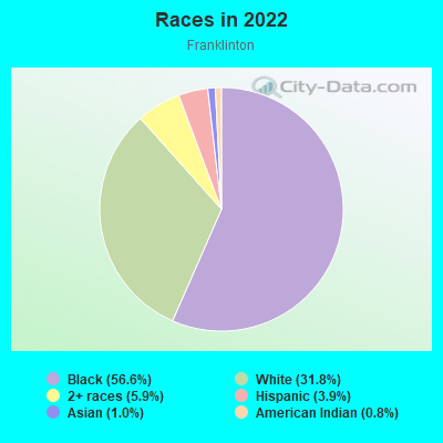
- 2,88756.6%Black
- 1,62531.8%White
- 3015.9%Two or more races
- 1983.9%Hispanic or Latino
- 521.0%Asian
- 410.8%American Indian
Median household income in 2022:
| Franklinton: | $34,616 |
| Columbus: | $61,727 |
Distribution of median household income
![Distribution of median household income]()
- 465Less than $10,000
- 572$10,000 to $19,999
- 181$20,000 to $29,999
- 169$30,000 to $39,999
- 222$40,000 to $49,999
- 73$50,000 to $59,999
- 134$60,000 to $74,999
- 519$75,000 to $99,999
- 56$100,000 to $124,999
- 241$125,000 to $149,999
- 139$150,000 to $199,999
- 102$200,000 or more

Distribution of owner-occupied house/condo value
![Distribution of owner-occupied house/condo value]()
- 418Less than $50,000
- 1,122$50,000 to $99,999
- 120$100,000 to $149,999
- 118$150,000 to $199,999
- 126$200,000 to $249,999
- 24$250,000 to $299,999
- 89$300,000 to $399,999
- 7$500,000 to $749,999
- 42$750,000 to $999,999

Distribution of rent paid by renters
![Distribution of rent paid by renters]()
- 66Less than $100
- 326$100 to $199
- 378$200 to $299
- 217$300 to $399
- 106$400 to $499
- 150$500 to $599
- 353$600 to $699
- 233$700 to $799
- 194$800 to $899
- 225$900 to $999
- 319$1,000 to $1,249
- 478$1,250 to $1,499
- 669$1,500 to $1,999
- 118$2,000 or more

Median rent in 2022:
| Franklinton: | $747 |
| Columbus: | $1,005 |
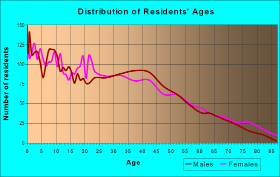
| Males: | 2,266 |
| Females: | 2,658 |
Males:
| This neighborhood: | 29.6 years |
| Whole city: | 32.9 years |
| This neighborhood: | 30.4 years |
| Whole city: | 33.7 years |
Average household size:
| Franklinton: | 2.5 people |
| Columbus: | 2.3 people |
Percentage of family households:
| Franklinton: | 40.7% |
| Columbus: | 40.8% |
| Here: | 7.9% |
| Columbus: | 30.8% |
Percentage of married-couple families with children (among all households):
| Franklinton: | 5.8% |
| Columbus: | 23.7% |
Percentage of single-mother households (among all households):
| Franklinton: | 36.8% |
| Columbus: | 15.7% |
Percentage of never married males 15 years old and over:
Percentage of never married females 15 years old and over:
| Franklinton: | 30.6% |
| Columbus: | 24.6% |
Percentage of never married females 15 years old and over:
| Franklinton: | 28.7% |
| city: | 21.9% |
Percentage of people that speak English not well or not at all:
| Franklinton: | 4.7% |
| Columbus: | 3.5% |
Percentage of people born in this state:
Percentage of people born in another U.S. state:
Percentage of native residents but born outside the U.S.:
Percentage of foreign born residents:
| Here: | 61.3% |
| Columbus: | 61.6% |
Percentage of people born in another U.S. state:
| Franklinton: | 30.3% |
| Columbus: | 22.4% |
Percentage of native residents but born outside the U.S.:
| Here: | 0.9% |
| city: | 1.3% |
Percentage of foreign born residents:
| Here: | 8.0% |
| Columbus: | 14.7% |

Owner-occupied
Renter-occupied

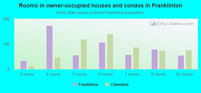
- Rooms in owner-occupied houses and condos in Franklinton
- 01 room
- 02 rooms
- 353 rooms
- 1744 rooms
- 575 rooms
- 1076 rooms
- 587 rooms
- 798 rooms
- 559+ rooms
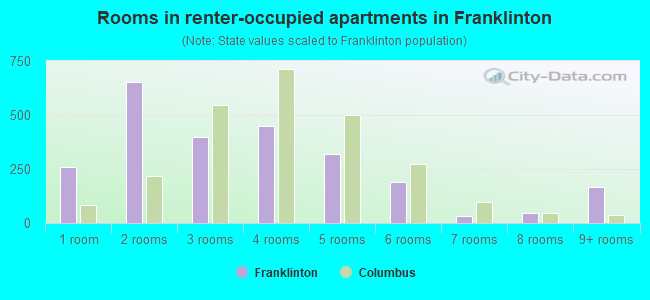
- Rooms in renter-occupied apartments in Franklinton
- 2571 room
- 6522 rooms
- 3993 rooms
- 4474 rooms
- 3215 rooms
- 1906 rooms
- 337 rooms
- 488 rooms
- 1669+ rooms
Owner-occupied
Renter-occupied
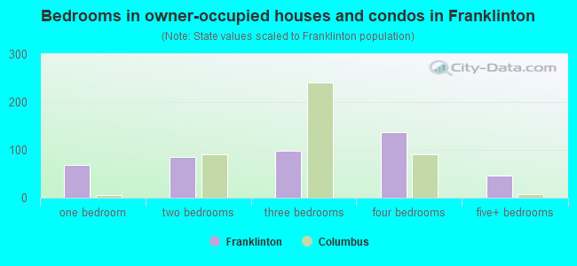
- Bedrooms in owner-occupied houses and condos in Franklinton
- 0no bedroom
- 681 bedroom
- 852 bedrooms
- 983 bedrooms
- 1374 bedrooms
- 465+ bedrooms
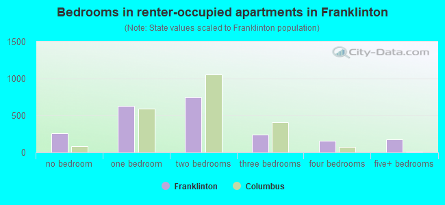
- Bedrooms in renter-occupied apartments in Franklinton
- 257no bedroom
- 6291 bedroom
- 7532 bedrooms
- 2413 bedrooms
- 1584 bedrooms
- 1795+ bedrooms
Average number of cars or other vehicles available in houses/condos:
Average number of cars or other vehicles available in apartments:
| This neighborhood: | 4.4 |
| Columbus: | 1.8 |
Average number of cars or other vehicles available in apartments:
| Here: | 1.0 |
| city: | 1.3 |
Percentage of units with a mortgage:
| Franklinton: | 18.2% |
| Columbus: | 69.3% |
Average estimated value of detached houses in 2022 (27.3% of all units):
| Franklinton: | $238,331 |
| Columbus: | $262,671 |
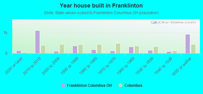
- Year house built in Franklinton
- 1322020 or later
- 1,1022010 to 2019
- 1032000 to 2009
- 3661990 to 1999
- 1791980 to 1989
- 1181970 to 1979
- 3121960 to 1969
- 1571950 to 1959
- 951940 to 1949
- 9271939 or earlier
City-data.com crime index for city in 2020 (higher means more crime):
| City: | 376.1 |
| U.S. average: | 219.5 |
Travel time to work (commute)
![Travel time to work (commute)]()
- 47Less than 5 minutes
- 2545 to 9 minutes
- 21910 to 14 minutes
- 31615 to 19 minutes
- 24520 to 24 minutes
- 6825 to 29 minutes
- 15030 to 34 minutes
- 9735 to 39 minutes
- 3940 to 44 minutes
- 7645 to 59 minutes
- 5860 to 89 minutes
- 9490 or more minutes

Means of transportation to work
![Means of transportation to work]()
- 66.8%1,003Drove a car alone
- 9.2%138Carpooled
- 6.9%104Bus
- 0.3%5Bicycle
- 6.3%95Walked
- 4.0%60Other means
- 13.2%198Worked at home

Time leaving home to go to work
![Time leaving home to go to work]()
- 5312:00 a.m. to 4:59 a.m.
- 515:00 a.m. to 5:29 a.m.
- 675:30 a.m. to 5:59 a.m.
- 536:00 a.m. to 6:29 a.m.
- 806:30 a.m. to 6:59 a.m.
- 1317:00 a.m. to 7:29 a.m.
- 587:30 a.m. to 7:59 a.m.
- 2488:00 a.m. to 8:29 a.m.
- 838:30 a.m. to 8:59 a.m.
- 999:00 a.m. to 9:59 a.m.
- 7710:00 a.m. to 10:59 a.m.
- 12011:00 a.m. to 11:59 a.m.
- 11612:00 p.m. to 3:59 p.m.
- 1794:00 p.m. to 11:59 p.m.

Occupations of males:
- Percentage of males in management occupations (except farmers):
Here: 8.8% city: 10.2%
- Percentage of males in business and financial operations occupations:
Here: 11.9% city: 6.2%
- Percentage of males in computer and mathematical occupations:
Here: 3.0% city: 7.7%
- Percentage of males in life, physical, and social science occupations:
Here: 2.4% city: 1.1%
- Percentage of males in education, training, and library occupations:
Here: 3.2% city: 3.8%
- Percentage of males in arts, design, entertainment, sports, and media occupations:
Here: 5.0% city: 2.1%
- Percentage of males in healthcare practitioners and technical occupations:
Here: 6.0% city: 2.9%
- Percentage of males in service occupations:
Here: 20.8% city: 13.8%
- Percentage of males in sales and office occupations:
Here: 16.9% city: 17.0%
- Percentage of males in construction, extraction, and maintenance occupations:
Here: 2.2% city: 5.2%
- Percentage of males in production occupations:
Here: 3.8% city: 6.5%
- Percentage of males in transportation occupations:
Here: 2.4% city: 6.4%
- Percentage of males in material moving occupations:
Here: 10.8% city: 7.9%
Occupations of females:
- Percentage of females in management occupations (except farmers):
Here: 10.8% city: 10.0%
- Percentage of females in business and financial operations occupations:
Here: 6.4% city: 8.2%
- Percentage of females in computer and mathematical occupations:
Here: 1.8% city: 2.6%
- Percentage of females in life, physical, and social science occupations:
Here: 2.9% city: 1.2%
- Percentage of females in legal occupations:
Here: 5.0% city: 1.3%
- Percentage of females in education, training, and library occupations:
Here: 3.2% city: 7.9%
- Percentage of females in healthcare practitioners and technical occupations:
Here: 4.2% city: 10.2%
- Percentage of females in service occupations:
Here: 33.0% city: 19.3%
- Percentage of females in sales and office occupations:
Here: 15.4% city: 25.0%
- Percentage of females in production occupations:
Here: 10.1% city: 3.0%
- Percentage of females in transportation occupations:
Here: 4.3% city: 1.3%
- Percentage of females in material moving occupations:
Here: 1.5% city: 3.7%
Education in this neighborhood (subdivision or community):
- Percentage of people 3 years and older in K-12 schools:
Franklinton: 27.9% Columbus: 15.2%
- Percentage of people 3 years and older in undergraduate colleges:
Franklinton: 8.5% Columbus: 6.7%
- Percentage of people 3 years and older in grad. or professional schools:
Franklinton: 6.4% Columbus: 2.4%
- Percentage of students K-12 enrolled in private schools:
Franklinton: 43.7% Columbus: 13.8%
Percentage of population below poverty level:
| Franklinton: | 53.5% |
| Columbus: | 18.1% |
Percentage of married-couple families with both working:
| Franklinton: | 151.9% |
| Columbus: | 75.5% |

- 55.1%Utility gas
- 35.8%Electricity
- 4.9%No fuel used
- 2.7%Other fuel
- 0.9%Bottled, tank, or LP gas
- 0.7%Fuel oil, kerosene, etc.
Limited-access highways (interstate or state) in this neighborhood:
I- 70 (West Fwy)
Length: 5.14 miles
Directions: E-W, SE-NW, SW-NE
Directions: E-W, SE-NW, SW-NE
I- 71 (South Fwy)
Length: 1.10 miles
Directions: E-W, N-S, SE-NW, SW-NE
Directions: E-W, N-S, SE-NW, SW-NE
I- 670
Length: 0.14 miles
Direction: E-W
Direction: E-W
Highways in this neighborhood:
W Broad St (National Rd SW, US Hwy 40)
Length: 2.28 miles
Direction: E-W
Address range: 419 to 1650
Direction: E-W
Address range: 419 to 1650
W Innerbelt (State Rte 315)
Length: 1.23 miles
Direction: N-S
Address range: 529 to 1197
Direction: N-S
Address range: 529 to 1197
S Central Ave (US Hwy 62, State Rte 3)
Length: 0.84 miles
Directions: N-S, SE-NW
Address range: 1 to 575
Directions: N-S, SE-NW
Address range: 1 to 575
Roads and streets:
Mc Kinley Ave
Length: 2.55 miles
Directions: E-W, N-S, SE-NW
Address range: 793 to 2160
Directions: E-W, N-S, SE-NW
Address range: 793 to 2160
W Town St
Length: 1.94 miles
Direction: E-W
Address range: 393 to 1499
Direction: E-W
Address range: 393 to 1499
W Rich St
Length: 1.82 miles
Direction: E-W
Address range: 380 to 1499
Direction: E-W
Address range: 380 to 1499
W State St
Length: 1.72 miles
Direction: E-W
Address range: 387 to 1410
Direction: E-W
Address range: 387 to 1410
Sullivant Ave
Length: 1.63 miles
Direction: E-W
Address range: 560 to 1450
Direction: E-W
Address range: 560 to 1450
W Mound St
Length: 1.21 miles
Directions: E-W, N-S, SE-NW
Address range: 743 to 1414
Directions: E-W, N-S, SE-NW
Address range: 743 to 1414
W Gay St
Length: 1.06 miles
Direction: E-W
Address range: 457 to 1122
Direction: E-W
Address range: 457 to 1122
Thomas Ave
Length: 1.06 miles
Directions: E-W, SW-NE
Address range: 729 to 1318
Directions: E-W, SW-NE
Address range: 729 to 1318
Campbell Ave
Length: 1.06 miles
Directions: E-W, N-S
Address range: 701 to 1326
Directions: E-W, N-S
Address range: 701 to 1326
W Capital St
Length: 1.04 miles
Direction: E-W
Address range: 787 to 1408
Direction: E-W
Address range: 787 to 1408
W Park Ave
Length: 0.98 miles
Directions: E-W, N-S, SW-NE
Address range: 30 to 375
Directions: E-W, N-S, SW-NE
Address range: 30 to 375
Scott St
Length: 0.97 miles
Direction: E-W
Address range: 541 to 1130
Direction: E-W
Address range: 541 to 1130
S Souder Ave
Length: 0.93 miles
Directions: N-S, SE-NW
Address range: 1 to 755
Directions: N-S, SE-NW
Address range: 1 to 755
Bellows Ave
Length: 0.90 miles
Directions: E-W, SW-NE
Address range: 700 to 1210
Directions: E-W, SW-NE
Address range: 700 to 1210
Dakota Ave
Length: 0.86 miles
Directions: N-S, SE-NW
Address range: 1 to 449
Directions: N-S, SE-NW
Address range: 1 to 449
S Glenwood Ave
Length: 0.76 miles
Direction: N-S
Address range: 1 to 531
Direction: N-S
Address range: 1 to 531
S Cypress Ave
Length: 0.75 miles
Direction: N-S
Address range: 1 to 521
Direction: N-S
Address range: 1 to 521
Martin Ave
Length: 0.73 miles
Direction: N-S
Address range: 1 to 312
Direction: N-S
Address range: 1 to 312
Brehl Ave
Length: 0.73 miles
Directions: N-S, SE-NW
Address range: 1 to 557
Directions: N-S, SE-NW
Address range: 1 to 557
Harmon Ave
Length: 0.71 miles
Directions: E-W, N-S, SE-NW
Address range: 468 to 959
Directions: E-W, N-S, SE-NW
Address range: 468 to 959
Avondale Ave
Length: 0.67 miles
Direction: N-S
Address range: 1 to 548
Direction: N-S
Address range: 1 to 548
Hawkes Ave
Length: 0.66 miles
Direction: N-S
Address range: 1 to 440
Direction: N-S
Address range: 1 to 440
S Yale Ave
Length: 0.66 miles
Direction: N-S
Address range: 1 to 461
Direction: N-S
Address range: 1 to 461
Dana Ave
Length: 0.64 miles
Direction: N-S
Address range: 1 to 549
Direction: N-S
Address range: 1 to 549
Cable Ave
Length: 0.63 miles
Directions: E-W, SW-NE
Address range: 1000 to 1412
Directions: E-W, SW-NE
Address range: 1000 to 1412
S Princeton Ave
Length: 0.58 miles
Direction: N-S
Address range: 1 to 541
Direction: N-S
Address range: 1 to 541
Grandview Ave
Length: 0.56 miles
Directions: E-W, N-S, SE-NW, SW-NE
Address range: 301 to 378
Directions: E-W, N-S, SE-NW, SW-NE
Address range: 301 to 378
W Walnut St
Length: 0.55 miles
Direction: E-W
Address range: 442 to 924
Direction: E-W
Address range: 442 to 924
S Davis Ave
Length: 0.55 miles
Direction: N-S
Address range: 1 to 426
Direction: N-S
Address range: 1 to 426
W Chapel St
Length: 0.48 miles
Direction: E-W
Address range: 429 to 738
Direction: E-W
Address range: 429 to 738
Plain Aly
Length: 0.43 miles
Direction: E-W
Address range: 701 to 942
Direction: E-W
Address range: 701 to 942
N Central Ave
Length: 0.42 miles
Directions: N-S, SE-NW
Address range: 1 to 299
Directions: N-S, SE-NW
Address range: 1 to 299
S Grubb St
Length: 0.42 miles
Direction: N-S
Address range: 1 to 299
Direction: N-S
Address range: 1 to 299
S Gift St
Length: 0.42 miles
Direction: N-S
Address range: 1 to 299
Direction: N-S
Address range: 1 to 299
Cherry Aly
Length: 0.41 miles
Direction: E-W
Address range: 701 to 942
Direction: E-W
Address range: 701 to 942
Mc Dowell St
Length: 0.38 miles
Direction: N-S
Address range: 1 to 298
Direction: N-S
Address range: 1 to 298
S Skidmore St
Length: 0.37 miles
Direction: N-S
Address range: 1 to 299
Direction: N-S
Address range: 1 to 299
Mount Calvary Ave
Length: 0.35 miles
Directions: N-S, SE-NW
Address range: 518 to 735
Directions: N-S, SE-NW
Address range: 518 to 735
Schultz Ave
Length: 0.35 miles
Direction: N-S
Address range: 1 to 247
Direction: N-S
Address range: 1 to 247
Van Buren Dr
Length: 0.35 miles
Directions: E-W, N-S, SE-NW, SW-NE
Address range: 548 to 667
Directions: E-W, N-S, SE-NW, SW-NE
Address range: 548 to 667
N Yale Ave
Length: 0.34 miles
Direction: N-S
Address range: 1 to 246
Direction: N-S
Address range: 1 to 246
Stevens Ave
Length: 0.34 miles
Direction: N-S
Address range: 1 to 233
Direction: N-S
Address range: 1 to 233
River St
Length: 0.33 miles
Direction: E-W
Address range: 677 to 1424
Direction: E-W
Address range: 677 to 1424
N Guilford Ave
Length: 0.33 miles
Directions: E-W, N-S, SE-NW
Address range: 1 to 222
Directions: E-W, N-S, SE-NW
Address range: 1 to 222
Renick St
Length: 0.33 miles
Direction: E-W
Address range: 700 to 899
Direction: E-W
Address range: 700 to 899
Hayden Ave
Length: 0.32 miles
Direction: N-S
Address range: 1 to 275
Direction: N-S
Address range: 1 to 275
Greenfield Dr
Length: 0.31 miles
Directions: N-S, SE-NW, SW-NE
Address range: 739 to 934
Directions: N-S, SE-NW, SW-NE
Address range: 739 to 934
N Princeton Ave
Length: 0.31 miles
Direction: N-S
Address range: 1 to 266
Direction: N-S
Address range: 1 to 266
Rodgers Ave
Length: 0.29 miles
Direction: N-S
Address range: 1 to 199
Direction: N-S
Address range: 1 to 199
S Green St
Length: 0.29 miles
Direction: N-S
Address range: 43 to 300
Direction: N-S
Address range: 43 to 300
John St
Length: 0.29 miles
Direction: E-W
Address range: 800 to 999
Direction: E-W
Address range: 800 to 999
Scioto Blvd
Length: 0.28 miles
Directions: N-S, SW-NE
Address range: 289 to 425
Directions: N-S, SW-NE
Address range: 289 to 425
Griggs Ave
Length: 0.27 miles
Direction: E-W
Address range: 695 to 848
Direction: E-W
Address range: 695 to 848
Chicago Ave
Length: 0.27 miles
Direction: N-S
Address range: 1 to 199
Direction: N-S
Address range: 1 to 199
Wisconsin Ave
Length: 0.26 miles
Direction: N-S
Address range: 1 to 182
Direction: N-S
Address range: 1 to 182
Coolidge Dr
Length: 0.25 miles
Directions: E-W, N-S
Address range: 722 to 896
Directions: E-W, N-S
Address range: 722 to 896
Wharton Ave
Length: 0.25 miles
Direction: E-W
Address range: 462 to 673
Direction: E-W
Address range: 462 to 673
S Hartford Ave
Length: 0.24 miles
Direction: N-S
Address range: 1 to 169
Direction: N-S
Address range: 1 to 169
Miner Ave
Length: 0.24 miles
Directions: E-W, N-S, SW-NE
Address range: 568 to 660
Directions: E-W, N-S, SW-NE
Address range: 568 to 660
Buchanan Dr
Length: 0.24 miles
Directions: E-W, SW-NE
Address range: 722 to 849
Directions: E-W, SW-NE
Address range: 722 to 849
Union Ave
Length: 0.23 miles
Directions: E-W, SW-NE
Address range: 1266 to 1399
Directions: E-W, SW-NE
Address range: 1266 to 1399
N Hartford Ave
Length: 0.22 miles
Directions: N-S, SE-NW
Address range: 1 to 180
Directions: N-S, SE-NW
Address range: 1 to 180
Culbertson St
Length: 0.22 miles
Direction: E-W
Address range: 541 to 687
Direction: E-W
Address range: 541 to 687
N Souder Ave
Length: 0.22 miles
Direction: N-S
Address range: 1 to 169
Direction: N-S
Address range: 1 to 169
Pierce Dr
Length: 0.22 miles
Direction: E-W
Address range: 637 to 820
Direction: E-W
Address range: 637 to 820
Cherry Dr
Length: 0.21 miles
Directions: E-W, N-S
Address range: 385 to 499
Directions: E-W, N-S
Address range: 385 to 499
Minard Aly
Length: 0.21 miles
Direction: E-W
Address range: 557 to 674
Direction: E-W
Address range: 557 to 674
S Mill St
Length: 0.19 miles
Direction: N-S
Address range: 1 to 133
Direction: N-S
Address range: 1 to 133
Jones Ave
Length: 0.19 miles
Direction: N-S
Address range: 1 to 180
Direction: N-S
Address range: 1 to 180
Lucas St
Length: 0.19 miles
Direction: N-S
Address range: 94 to 224
Direction: N-S
Address range: 94 to 224
Mead Aly
Length: 0.19 miles
Direction: N-S
Address range: 93 to 160
Direction: N-S
Address range: 93 to 160
Meek Ave
Length: 0.18 miles
Direction: N-S
Address range: 1 to 124
Direction: N-S
Address range: 1 to 124
Plato Dr
Length: 0.18 miles
Directions: N-S, SE-NW
Address range: 1 to 225
Directions: N-S, SE-NW
Address range: 1 to 225
N Glenwood Ave
Length: 0.17 miles
Directions: N-S, SW-NE
Address range: 1 to 113
Directions: N-S, SW-NE
Address range: 1 to 113
S May Ave
Length: 0.14 miles
Direction: N-S
Address range: 1 to 99
Direction: N-S
Address range: 1 to 99
Shepherd St
Length: 0.14 miles
Direction: E-W
Address range: 561 to 636
Direction: E-W
Address range: 561 to 636
Souder Ave
Length: 0.12 miles
Directions: N-S, SE-NW
Directions: N-S, SE-NW
N Green St
Length: 0.12 miles
Direction: N-S
Address range: 1 to 99
Direction: N-S
Address range: 1 to 99
Wendell Ave
Length: 0.12 miles
Direction: E-W
Address range: 1413 to 1478
Direction: E-W
Address range: 1413 to 1478
Merrimac Ave
Length: 0.12 miles
Direction: E-W
Address range: 1413 to 1483
Direction: E-W
Address range: 1413 to 1483
Kirby Ave
Length: 0.12 miles
Directions: N-S, SE-NW
Address range: 877 to 990
Directions: N-S, SE-NW
Address range: 877 to 990
N Grubb St
Length: 0.12 miles
Direction: N-S
Address range: 1 to 94
Direction: N-S
Address range: 1 to 94
Nace Ave
Length: 0.11 miles
Directions: N-S, SW-NE
Address range: 382 to 465
Directions: N-S, SW-NE
Address range: 382 to 465
N Gift St
Length: 0.10 miles
Direction: N-S
Address range: 1 to 62
Direction: N-S
Address range: 1 to 62
N Skidmore St
Length: 0.10 miles
Direction: N-S
Address range: 1 to 62
Direction: N-S
Address range: 1 to 62
N Mill St
Length: 0.10 miles
Direction: N-S
Address range: 1 to 60
Direction: N-S
Address range: 1 to 60
Foos St
Length: 0.10 miles
Direction: N-S
Address range: 1 to 61
Direction: N-S
Address range: 1 to 61
Princeton Ave
Length: 0.10 miles
Directions: N-S, SE-NW, SW-NE
Directions: N-S, SE-NW, SW-NE
Doyle St
Length: 0.09 miles
Directions: E-W, SE-NW
Address range: 739 to 786
Directions: E-W, SE-NW
Address range: 739 to 786
Mount Carmel Mall (W Capital St)
Length: 0.09 miles
Direction: E-W
Address range: 737 to 786
Direction: E-W
Address range: 737 to 786
Holton Ave
Length: 0.09 miles
Direction: N-S
Address range: 428 to 499
Direction: N-S
Address range: 428 to 499
Mt Carmel Mall
Length: 0.09 miles
Direction: E-W
Direction: E-W
Rickenbacher St
Length: 0.09 miles
Direction: E-W
Address range: 1400 to 1454
Direction: E-W
Address range: 1400 to 1454
Green St
Length: 0.09 miles
Directions: N-S, SE-NW
Directions: N-S, SE-NW
N Cypress Ave
Length: 0.09 miles
Direction: N-S
Address range: 146 to 204
Direction: N-S
Address range: 146 to 204
N Davis Ave
Length: 0.09 miles
Directions: N-S, SE-NW
Address range: 1 to 155
Directions: N-S, SE-NW
Address range: 1 to 155
Sandusky St
Length: 0.08 miles
Direction: N-S
Address range: 169 to 222
Direction: N-S
Address range: 169 to 222
Irene Pl
Length: 0.08 miles
Direction: E-W
Direction: E-W
Broderick St
Length: 0.08 miles
Direction: E-W
Address range: 477 to 538
Direction: E-W
Address range: 477 to 538
W Cherry St
Length: 0.08 miles
Direction: E-W
Address range: 515 to 559
Direction: E-W
Address range: 515 to 559
N May Ave
Length: 0.07 miles
Direction: N-S
Address range: 1 to 50
Direction: N-S
Address range: 1 to 50
Anson St
Length: 0.07 miles
Direction: N-S
Address range: 1 to 44
Direction: N-S
Address range: 1 to 44
Polk Dr
Length: 0.07 miles
Directions: N-S, SE-NW
Address range: 470 to 531
Directions: N-S, SE-NW
Address range: 470 to 531
Eaton Ave
Length: 0.06 miles
Direction: N-S
Address range: 876 to 959
Direction: N-S
Address range: 876 to 959
S Guilford Ave
Length: 0.06 miles
Direction: N-S
Address range: 300 to 382
Direction: N-S
Address range: 300 to 382
Plateau St
Length: 0.06 miles
Direction: N-S
Direction: N-S
May Ave
Length: 0.05 miles
Direction: N-S
Address range: 225 to 261
Direction: N-S
Address range: 225 to 261
Griggs Ct
Length: 0.04 miles
Direction: N-S
Address range: 700 to 798
Direction: N-S
Address range: 700 to 798
Harper Rd
Length: 0.04 miles
Directions: E-W, SW-NE
Address range: 2089 to 2118
Directions: E-W, SW-NE
Address range: 2089 to 2118
Rich St
Length: 0.04 miles
Direction: E-W
Direction: E-W
Capital St
Length: 0.04 miles
Direction: E-W
Direction: E-W
Yale Ave
Length: 0.03 miles
Direction: N-S
Direction: N-S
Railroad features:
Norfolk Southern Rlwy (Conrail RR)
Length: 6.10 miles
Directions: E-W, N-S, SE-NW, SW-NE
Directions: E-W, N-S, SE-NW, SW-NE
Baltimore and Ohio RR
Length: 1.08 miles
Directions: N-S, SW-NE
Directions: N-S, SW-NE
Chesapeake and Ohio Rlwy
Length: 0.62 miles
Directions: E-W, N-S, SE-NW
Directions: E-W, N-S, SE-NW
Other features:
Dry Run
Length: 0.05 miles
Direction: SW-NE
Direction: SW-NE